Tropical Storm Isaias
+31
Bkdude
sabamfa
SkiSeadooJoe
obsessedwithweather
essexcountypete
Grselig
New Yorker 234
Radz
docstox12
larryrock72
Vinnydula
dkodgis
rb924119
SoulSingMG
aiannone
sroc4
brownie
GreyBeard
Zhukov1945
HectorO
dsvinos
Sanchize06
amugs
weatherwatchermom
Dunnzoo
billg315
jmanley32
mwilli
frank 638
Sparky Sparticles
Frank_Wx
35 posters
Page 5 of 13
Page 5 of 13 •  1, 2, 3, 4, 5, 6 ... 11, 12, 13
 Re: Tropical Storm Isaias
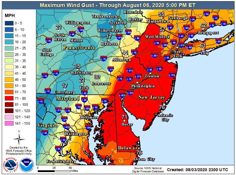
Upton just hasn’t updated their product yet (you can see clearly the CWA ‘border’ lol). They will if models hold.
SoulSingMG- Senior Enthusiast

- Posts : 2853
Join date : 2013-12-11
 Re: Tropical Storm Isaias
Does upton have this same map soul? I cannot find it people are asking about CT. you can also see that south of delaware didnt update, cuz how are they lower than all of jersey.SoulSingMG wrote:
Upton just hasn’t updated their product yet (you can see clearly the CWA ‘border’ lol). They will if models hold.
Last edited by jmanley32 on Mon Aug 03, 2020 11:37 pm; edited 1 time in total
jmanley32- Senior Enthusiast

- Posts : 20535
Join date : 2013-12-12
 Re: Tropical Storm Isaias
Alex Staarmann pro met wrote
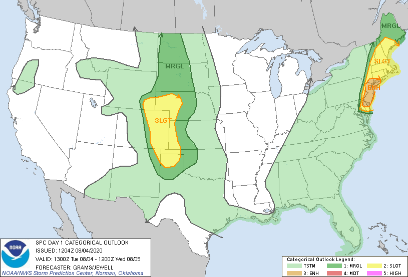
Cannot stress enough how severe #Isaias is likely to be for the I-95 east coast corridor. Damaging winds and flash flooding will cause significant impacts to the region. I just hope folks are taking this storm seriously, especially well inland.
Cannot stress enough how severe #Isaias is likely to be for the I-95 east coast corridor. Damaging winds and flash flooding will cause significant impacts to the region. I just hope folks are taking this storm seriously, especially well inland.
_________________
Mugs
AKA:King: Snow Weenie
Self Proclaimed
WINTER 2014-15 : 55.12" +.02 for 6 coatings (avg. 35")
WINTER 2015-16 Total - 29.8" (Avg 35")
WINTER 2016-17 : 39.5" so far

amugs- Advanced Forecaster - Mod

- Posts : 15095
Reputation : 213
Join date : 2013-01-07
Age : 54
Location : Hillsdale,NJ
 Re: Tropical Storm Isaias
Mugs where did you find that NJ wind map? I am trying to find it so i can see it updated for my area.

jmanley32- Senior Enthusiast

- Posts : 20535
Reputation : 108
Join date : 2013-12-12
Age : 43
Location : Yonkers, NY

SoulSingMG- Senior Enthusiast

- Posts : 2853
Reputation : 74
Join date : 2013-12-11
Location : Long Island City, NY
 Re: Tropical Storm Isaias
Last edited by Frank_Wx on Mon Aug 03, 2020 11:47 pm; edited 1 time in total
_________________
_______________________________________________________________________________________________________
CLICK HERE to view NJ Strong Snowstorm Classifications
 Re: Tropical Storm Isaias
Now lets see just how much he weakens, that will determine what happens up here, time is coming up quick we are still basically on schedule.

jmanley32- Senior Enthusiast

- Posts : 20535
Reputation : 108
Join date : 2013-12-12
Age : 43
Location : Yonkers, NY
 Re: Tropical Storm Isaias
jmanley32 wrote:Now lets see just how much he weakens, that will determine what happens up here, time is coming up quick we are still basically on schedule.
Actually, not entirely. Its interaction with the jet stream will help to enhance the winds up this way as it transitions to extra-tropical.
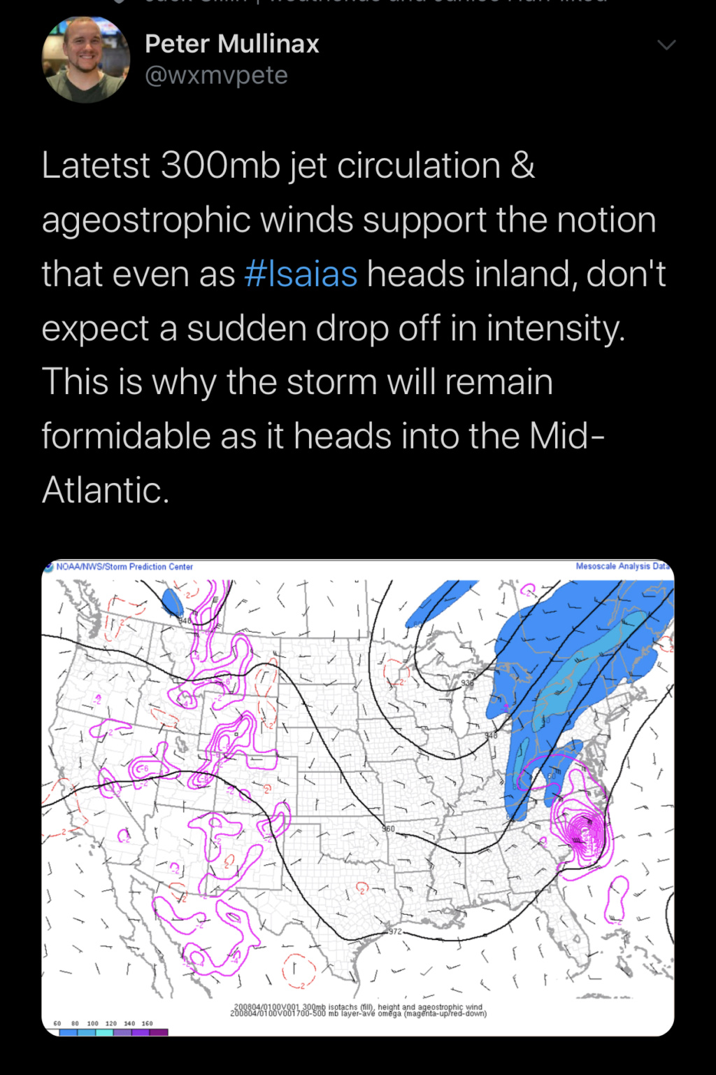
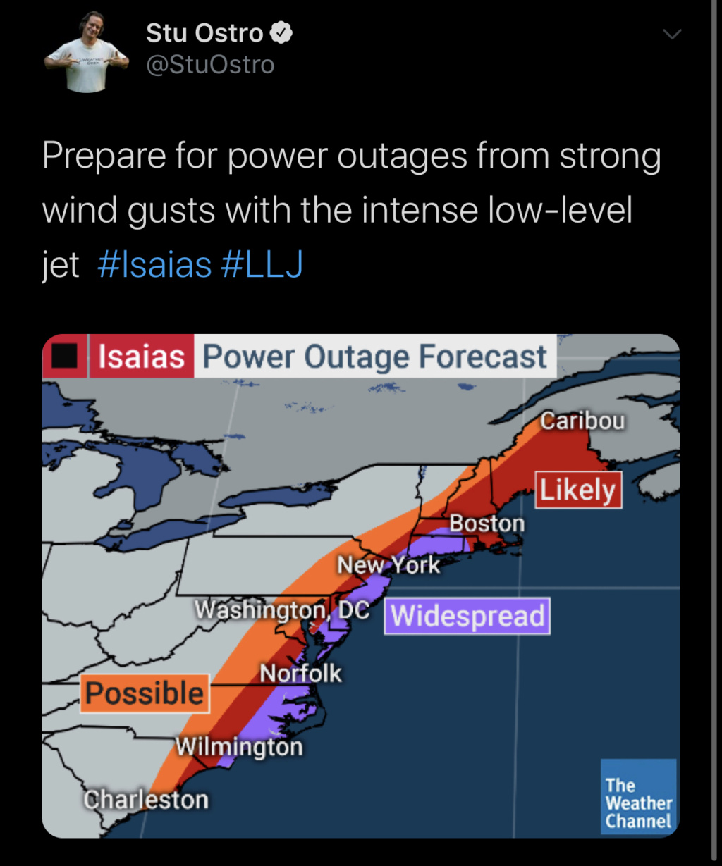
Also. I don’t like “them” but have much respect for Stu. Not often you see us in the “widespread outage” coloring.

SoulSingMG- Senior Enthusiast

- Posts : 2853
Reputation : 74
Join date : 2013-12-11
Location : Long Island City, NY
 Re: Tropical Storm Isaias
Wow, yes I know about the jet streak but his weakening before getting with that completely might play a part too. Yeah widespread not good, prolly go be watch transformers popping off like lightning tomorrow. Did you get a chance to get that updated NJ wind map for upton? I found something similar but it was nowhere near as high, still 70mph gusts (i think it COULD be higher) is bad enough. Sandys winds were only 70mph gusts here in my area and we got trashed. What was good about Sandy is it was fall, if we lose power for days its go be miserable no AC no fans no nothing.SoulSingMG wrote:jmanley32 wrote:Now lets see just how much he weakens, that will determine what happens up here, time is coming up quick we are still basically on schedule.
Actually, not entirely. Its interaction with the jet stream will help to enhance the winds up this way as it transitions to extra-tropical.
Also. I don’t like “them” but have much respect for Stu. Not often you see us in the “widespread outage” coloring.

jmanley32- Senior Enthusiast

- Posts : 20535
Reputation : 108
Join date : 2013-12-12
Age : 43
Location : Yonkers, NY
 Re: Tropical Storm Isaias
Here's a NWS impact map for winds
https://www.weather.gov/okx/tropical
https://www.weather.gov/okx/tropical
_________________
Janet
Snowfall winter of 2023-2024 17.5"
Snowfall winter of 2022-2023 6.0"
Snowfall winter of 2021-2022 17.6" 1" sleet 2/25/22
Snowfall winter of 2020-2021 51.1"
Snowfall winter of 2019-2020 8.5"
Snowfall winter of 2018-2019 25.1"
Snowfall winter of 2017-2018 51.9"
Snowfall winter of 2016-2017 45.6"
Snowfall winter of 2015-2016 29.5"
Snowfall winter of 2014-2015 50.55"
Snowfall winter of 2013-2014 66.5"
Dunnzoo- Senior Enthusiast - Mod

- Posts : 4904
Reputation : 68
Join date : 2013-01-11
Age : 62
Location : Westwood, NJ
 Re: Tropical Storm Isaias
Wow check out this cutoff! Portions of western NJ and EPA are going to flood with 4”+ rain while majority of us may never even see an inch out of it
https://radar.weather.gov/Conus/northeast_loop.php
https://radar.weather.gov/Conus/northeast_loop.php
_________________
_______________________________________________________________________________________________________
CLICK HERE to view NJ Strong Snowstorm Classifications
 Re: Tropical Storm Isaias

_________________
_______________________________________________________________________________________________________
CLICK HERE to view NJ Strong Snowstorm Classifications
 Re: Tropical Storm Isaias
Tornado watch up until 4pm
Sanchize06- Senior Enthusiast

- Posts : 1041
Reputation : 21
Join date : 2013-02-05
Location : Union Beach, NJ
 Re: Tropical Storm Isaias
Crazy with al lthat rain but nada for central NJ east wow, and his windfield is tiny is it supposed to expand cuz taking a even further west track now i do not see how out to cape cod sees TS conditions.

jmanley32- Senior Enthusiast

- Posts : 20535
Reputation : 108
Join date : 2013-12-12
Age : 43
Location : Yonkers, NY
 Re: Tropical Storm Isaias
I haven’t been able to post meaningfully because of work and family, but first and foremost I’d like to quickly say that my preliminary outlook for this storm was half and half. The bad-half was my track, as I was about 100 miles too Far East. While my ideas of a deeper trough verified, the eastward progression did not. I’ll have to go back and see why later. The good-half of my outlook was the intensity; this system pretty much remained steady-state after the initial strengthening occurred upon exiting the islands (fluctuated around a mean high-end tropical storm).
That said, I am really not seeing the reason for a lot of the excitement for these big winds up this way. I think it’s pretty much going be the rain that becomes the story with this system. Wind-wise, I don’t think it’s anything to write home about. You’re not dealing with the type/degree of baroclinicity that you need in order to generate the kinds of wind speeds some of the models are printing out. The dynamics aloft are impressive, no doubt, which is why you’re seeing all the rain across PA. But the problem is that’s largely not going to translate all the way to the surface, in my opinion, because of how the dynamics are being distributed. I think those of us along and east of the track see some 50-60 kt gusts, but no more than that. I’m on LBI, so I’ll be the first to say I was wrong, though lol
That said, I am really not seeing the reason for a lot of the excitement for these big winds up this way. I think it’s pretty much going be the rain that becomes the story with this system. Wind-wise, I don’t think it’s anything to write home about. You’re not dealing with the type/degree of baroclinicity that you need in order to generate the kinds of wind speeds some of the models are printing out. The dynamics aloft are impressive, no doubt, which is why you’re seeing all the rain across PA. But the problem is that’s largely not going to translate all the way to the surface, in my opinion, because of how the dynamics are being distributed. I think those of us along and east of the track see some 50-60 kt gusts, but no more than that. I’m on LBI, so I’ll be the first to say I was wrong, though lol
rb924119- Meteorologist

- Posts : 6928
Reputation : 194
Join date : 2013-02-06
Age : 32
Location : Greentown, Pa
 Re: Tropical Storm Isaias
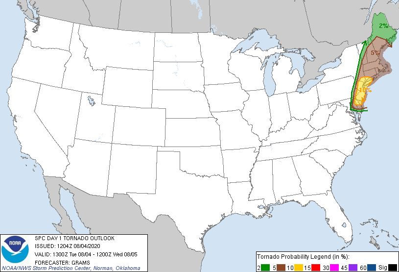
Wow im a bit nervous about the tornado threat, theres currently 7 tornado warnings south of here one already n PA!

jmanley32- Senior Enthusiast

- Posts : 20535
Reputation : 108
Join date : 2013-12-12
Age : 43
Location : Yonkers, NY
 Re: Tropical Storm Isaias
Ray I did not realize you moved to LI
_________________
_______________________________________________________________________________________________________
CLICK HERE to view NJ Strong Snowstorm Classifications
 Re: Tropical Storm Isaias
I completely agree that gusts in the 55 to 65mph range are probaby the most likely, and I think we all pretty much have debunked the Euro NAM UKMET etc. but i guess its always possible, the tornado threat seems real though, the lack of rain east of the storm though would seem to make bringing winds down much harder, do you see the wind field growing east at all or is there no warrant for TS warnings so far east into Cape cod and NE, as the field sits now no way it reaches past central eastern CT.rb924119 wrote:I haven’t been able to post meaningfully because of work and family, but first and foremost I’d like to quickly say that my preliminary outlook for this storm was half and half. The bad-half was my track, as I was about 100 miles too Far East. While my ideas of a deeper trough verified, the eastward progression did not. I’ll have to go back and see why later. The good-half of my outlook was the intensity; this system pretty much remained steady-state after the initial strengthening occurred upon exiting the islands (fluctuated around a mean high-end tropical storm).
That said, I am really not seeing the reason for a lot of the excitement for these big winds up this way. I think it’s pretty much going be the rain that becomes the story with this system. Wind-wise, I don’t think it’s anything to write home about. You’re not dealing with the type/degree of baroclinicity that you need in order to generate the kinds of wind speeds some of the models are printing out. The dynamics aloft are impressive, no doubt, which is why you’re seeing all the rain across PA. But the problem is that’s largely not going to translate all the way to the surface, in my opinion, because of how the dynamics are being distributed. I think those of us along and east of the track see some 50-60 kt gusts, but no more than that. I’m on LBI, so I’ll be the first to say I was wrong, though lol

jmanley32- Senior Enthusiast

- Posts : 20535
Reputation : 108
Join date : 2013-12-12
Age : 43
Location : Yonkers, NY
 Re: Tropical Storm Isaias
Frank_Wx wrote:Ray I did not realize you moved to LI
Not Long Island, Long Beach* Island, NJ haha and I’m only down here on account of the virus. My office is still closed in Fishkill, and with gyms still closed with no sign of opening I had to get out lol so I’ve been seeking refuge down here since Memorial Day, set my old weight set up in the garage......it’s been good haha
rb924119- Meteorologist

- Posts : 6928
Reputation : 194
Join date : 2013-02-06
Age : 32
Location : Greentown, Pa
 Re: Tropical Storm Isaias
jmanley32 wrote:I completely agree that gusts in the 55 to 65mph range are probaby the most likely, and I think we all pretty much have debunked the Euro NAM UKMET etc. but i guess its always possible, the tornado threat seems real though, the lack of rain east of the storm though would seem to make bringing winds down much harder, do you see the wind field growing east at all or is there no warrant for TS warnings so far east into Cape cod and NE, as the field sits now no way it reaches past central eastern CT.rb924119 wrote:I haven’t been able to post meaningfully because of work and family, but first and foremost I’d like to quickly say that my preliminary outlook for this storm was half and half. The bad-half was my track, as I was about 100 miles too Far East. While my ideas of a deeper trough verified, the eastward progression did not. I’ll have to go back and see why later. The good-half of my outlook was the intensity; this system pretty much remained steady-state after the initial strengthening occurred upon exiting the islands (fluctuated around a mean high-end tropical storm).
That said, I am really not seeing the reason for a lot of the excitement for these big winds up this way. I think it’s pretty much going be the rain that becomes the story with this system. Wind-wise, I don’t think it’s anything to write home about. You’re not dealing with the type/degree of baroclinicity that you need in order to generate the kinds of wind speeds some of the models are printing out. The dynamics aloft are impressive, no doubt, which is why you’re seeing all the rain across PA. But the problem is that’s largely not going to translate all the way to the surface, in my opinion, because of how the dynamics are being distributed. I think those of us along and east of the track see some 50-60 kt gusts, but no more than that. I’m on LBI, so I’ll be the first to say I was wrong, though lol
No, I don’t think it grows. It’s going to decrease in intensity and elongate along the frontal structure. as it lifts northward. But remember, they changed the conventions for tropical storm/hurricane advisory criteria........it no longer matters how the storm is classified in order to issue those, so that’s why they go far along the coast.
rb924119- Meteorologist

- Posts : 6928
Reputation : 194
Join date : 2013-02-06
Age : 32
Location : Greentown, Pa
 Re: Tropical Storm Isaias
Wel ray the TS warning still has me gusting to 70-75mph at some pt today, so we will see. To me 70mph is pretty intense, and certainly enough to cause a lot of issues here as we have a lot of full trees. Couled with the tornado threat which im guessing comes mainly fro mthat arcing band off the water should make for a interesting day.
Last edited by jmanley32 on Tue Aug 04, 2020 8:10 am; edited 1 time in total

jmanley32- Senior Enthusiast

- Posts : 20535
Reputation : 108
Join date : 2013-12-12
Age : 43
Location : Yonkers, NY
 Re: Tropical Storm Isaias
So it doesnt grow but the wind coverage area will increae whats the difference, lol sorry yes since sandy they changed it if impacts are the same they put up TS issuances.rb924119 wrote:jmanley32 wrote:I completely agree that gusts in the 55 to 65mph range are probaby the most likely, and I think we all pretty much have debunked the Euro NAM UKMET etc. but i guess its always possible, the tornado threat seems real though, the lack of rain east of the storm though would seem to make bringing winds down much harder, do you see the wind field growing east at all or is there no warrant for TS warnings so far east into Cape cod and NE, as the field sits now no way it reaches past central eastern CT.rb924119 wrote:I haven’t been able to post meaningfully because of work and family, but first and foremost I’d like to quickly say that my preliminary outlook for this storm was half and half. The bad-half was my track, as I was about 100 miles too Far East. While my ideas of a deeper trough verified, the eastward progression did not. I’ll have to go back and see why later. The good-half of my outlook was the intensity; this system pretty much remained steady-state after the initial strengthening occurred upon exiting the islands (fluctuated around a mean high-end tropical storm).
That said, I am really not seeing the reason for a lot of the excitement for these big winds up this way. I think it’s pretty much going be the rain that becomes the story with this system. Wind-wise, I don’t think it’s anything to write home about. You’re not dealing with the type/degree of baroclinicity that you need in order to generate the kinds of wind speeds some of the models are printing out. The dynamics aloft are impressive, no doubt, which is why you’re seeing all the rain across PA. But the problem is that’s largely not going to translate all the way to the surface, in my opinion, because of how the dynamics are being distributed. I think those of us along and east of the track see some 50-60 kt gusts, but no more than that. I’m on LBI, so I’ll be the first to say I was wrong, though lol
No, I don’t think it grows. It’s going to decrease in intensity and elongate along the frontal structure. as it lifts northward. But remember, they changed the conventions for tropical storm/hurricane advisory criteria........it no longer matters how the storm is classified in order to issue those, so that’s why they go far along the coast.

jmanley32- Senior Enthusiast

- Posts : 20535
Reputation : 108
Join date : 2013-12-12
Age : 43
Location : Yonkers, NY
 Re: Tropical Storm Isaias
8am still a 70mph TS trucking at 33mph wow, he really is maintaining intensity at 70mph for a long time now being inland that jet really is keeping him from weakening much.

jmanley32- Senior Enthusiast

- Posts : 20535
Reputation : 108
Join date : 2013-12-12
Age : 43
Location : Yonkers, NY
 Re: Tropical Storm Isaias
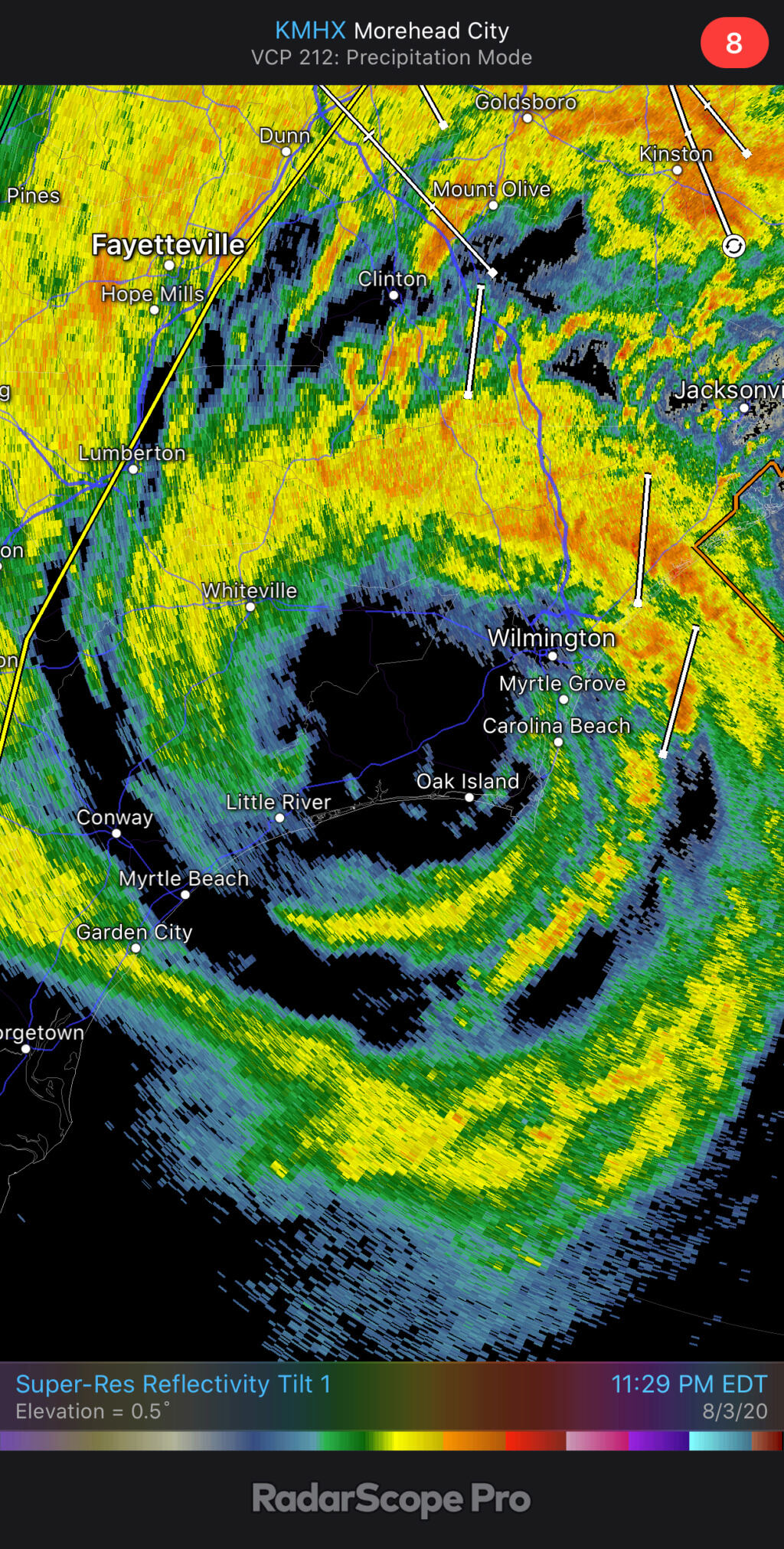
wow im see damage video from oak island really bad houses collapsed, feet of sand into homes

jmanley32- Senior Enthusiast

- Posts : 20535
Reputation : 108
Join date : 2013-12-12
Age : 43
Location : Yonkers, NY

jmanley32- Senior Enthusiast

- Posts : 20535
Reputation : 108
Join date : 2013-12-12
Age : 43
Location : Yonkers, NY
 Re: Tropical Storm Isaias
This storm is moving double-time now. At this speed I wouldn’t be surprised if some areas of NJ are in sunshine before the end of the afternoon. I think the prolonged heavy rain seems locked over eastern PA/western NJ and the rest of the area sees some bands and storms off and on with one main area of heavy rain moving through between noon and 3 pm. The winds may still be a factor, but as Frank said, a good chunk of NJ will see only moderate rainfall totals.

billg315- Advanced Forecaster - Mod

- Posts : 4483
Reputation : 185
Join date : 2015-01-24
Age : 50
Location : Flemington, NJ
 Re: Tropical Storm Isaias
Up here in northern Orange just a mile from Sullivan, light rain since 3 ish but steady and still no wind. I don’t need “exciting” so good. In fact right now at almost 9 am, the rain has stopped. I expect it to get worse but it is an under the covers and a Netflix day so far

dkodgis- Senior Enthusiast

- Posts : 2560
Reputation : 98
Join date : 2013-12-29
Page 5 of 13 •  1, 2, 3, 4, 5, 6 ... 11, 12, 13
Page 5 of 13
Permissions in this forum:
You cannot reply to topics in this forum|
|
|

 Home
Home