12/16 to 12/17 Godzilla - 1st Call Snow Map
+40
gigs68
WeatherBob
SENJsnowman
Wheezer
Dunnzoo
nutleyblizzard
MattyICE
Irish
bloc1357
RJB8525
rb924119
bobjohnsonforthehall
essexcountypete
elkiehound
DAYBLAZER
crippo84
amugs
heehaw453
sabamfa
CPcantmeasuresnow
sroc4
phil155
docstox12
adamfitz1969
algae888
Math23x7
jimv45
weatherwatchermom
Artechmetals
SoulSingMG
mwilli
billg315
jmanley32
dsix85
Scullybutcher
oldtimer
hyde345
frank 638
aiannone
Frank_Wx
44 posters
Page 6 of 12
Page 6 of 12 •  1, 2, 3 ... 5, 6, 7 ... 10, 11, 12
 Re: 12/16 to 12/17 Godzilla - 1st Call Snow Map
jmanley32 wrote:Uptons briefing, they still thinking go be a hard impact storm, with uncertainty for LI. This is a pdf file no way to post it as a image.
https://www.weather.gov/media/okx/winterstorm_public.pdf
Note just realized this is as of 6am, they will have another briefing tonight or in the AM. If they change their forecast then you know we are in trouble. Though they have been known to shift back and forth too.
That’s with a 6am time stamp.
But I doubt they reverse course until 18z’s run (if they continue to show NW trend)...
SoulSingMG- Senior Enthusiast

- Posts : 2853
Join date : 2013-12-11
aiannone- Senior Enthusiast - Mod

- Posts : 4815
Join date : 2013-01-07
 Re: 12/16 to 12/17 Godzilla - 1st Call Snow Map
12z UKIE takes the low over philly
_________________
-Alex Iannone-

aiannone- Senior Enthusiast - Mod

- Posts : 4815
Reputation : 92
Join date : 2013-01-07
Location : Saint James, LI (Northwest Suffolk Co.)
 Re: 12/16 to 12/17 Godzilla - 1st Call Snow Map
Frank_Wx wrote:A couple of things:
1. How many consecutive days did the GFS try to suppress the storm? Yesterday it made subtle shifts NW, and the EURO made a shift SE, and we thought they were meeting in the middle for consensus. Turns out, GFS has been wrong all along (so it seems after today's run), which begs the question why we even look at it??
2. It appears the NW shift is real, and many areas including CNJ/SNJ will see their forecasted snow amounts drop considerably on my final call map, but I am still thinking we're not done with seeing models move around. I don't think the final solution is shown on the models yet. It's possible this storm comes even MORE NW, given the negative trends we're seeing with the 50/50 and H5 trough, OR the models decide to tick back S-SE in response to the HP to the north.
3. I know point #2 sounded political or a typical "non-wrong" response, but there really is so much uncertainty with several features. I called some of them out in point #2, but the biggest question mark is where the 700mb and 850mb track. Ultimately that will depend on what the 500mb ULL decides to do too. We have not seen enough consistency from any one model to truly have a feel for this storm yet.
4. This just reminds you that people like RB and others are an asset to this board, because they can call BS on some of these model runs in an instant!
Let's see what the rest of today brings. Also, just a reminder to keep banter comments in the banter thread.
Great post, Frank! If I may, I’d like to follow up with some additional comments:
1. I agree that all of the money that NCEP invested has been a waste on the GFS - they never fixed the underlying problems, just revamped them. That said, it’s a tool to be used for guidance, just like they all are. It’s up to forecasters to interpret them and their output and make a forecast, but I think (and this is NOT IN ANY WAY DIRECTED AT YOU) too many people forget that, especially mainstream/social media, etc.
2. I agree on all accounts. Typically when you see big adjustments, there is usually a bit of follow-up response in the opposite direction later on, though of much lesser magnitude. It’s also unclear if it takes another cycle to slow the apparent trend before reversing (meaning 12z runs tomorrow would reflect the small reversal after another, much smaller northwest shift/maintenance of current run at 00z tonight), or it happens tonight at 00z. However, I personally favor a general maintenance/slight further northwest correction of some guidance based on my ideas.
3. My sentiments for this are pretty much reflected in the first point - every forecaster is different in his/her approach and comfort level with implementing subjectivity, so, I personally don’t see your response as necessarily political or “not-wrong”. You put an initial call out just like I did. You put hard numbers down and took a stance. If you end up changing that, it’s not because you were flip-flopping, it’s because things changed your analysis. Nothing wrong with that, especially when the factors that may lead to changes were highlighted and discussed in your preliminary forecast. I don’t think anybody could find fault with that.
4. A sincere thank you for your comments, as well as for everybody else’s. I LOVE being here and being able to just bounce ideas around and have enjoyable debates about them. That’s what it’s all about, as well as trying to hone our skills in the process. This crowd is so much better than other places I’ve been, and as I said, this will be the only forum that I post on from now on because we can have such enjoyable and free-flowing debates, no matter the level of knowledge or skill. There are no egos here. All of that said, I find it important to point out that I learned from you all starting back on the old ABC7 forum. You taught me about pattern recognition, and how to look at the atmosphere as an interconnected machine with all of the cogs turning together, not as separate entities, which was something that I never even heard about at that time. So, for everything that I’ve learned and been able to develop further and then share back, that’s all because of you guys. I want to make that clear
Lastly, the storm hasn’t happened yet. Like you said, let’s see what happens over the next 18 hours.
rb924119- Meteorologist

- Posts : 6928
Reputation : 194
Join date : 2013-02-06
Age : 32
Location : Greentown, Pa
Frank_Wx and RJB8525 like this post
 Re: 12/16 to 12/17 Godzilla - 1st Call Snow Map
jmanley32 wrote:So no SE movement just NW? Should I let my sister know to expect a lot of snow in syracuse or is that too far north?Frank_Wx wrote:MattyICE wrote:I have to say, RB has been fantastic and was eviscersted elsewhere for his less than optimistic view of this storm from a week + out. All the things he’s warned about and seen are POTENTIALLY rearing their ugly heads here. Now could things shift back today? Of course, and I think to
Some extent they will...but even if we all get rescued with 2 feet of snow, it will still mean that he handled this better than most. I don’t know him, but have lurked a while and posted infrequently, but he’s one of the best I follow. Let’s see what today brings.
Agreed!!! Regardless of the outcome (honestly this thing still has room to come even more NW), he has been terrific with his analysis and presentation of it all.
Give it some time my man. Nobody said no SE movement. See how things continue to trend today.

crippo84- Posts : 383
Reputation : 20
Join date : 2013-11-07
Age : 40
Location : East Village, NYC
 Re: 12/16 to 12/17 Godzilla - 1st Call Snow Map
Something is wonky with that Ukie run. It has a low over philly which by the way would never happen with a 1035 high up north then ends up exploding to 977mb south of LI. No other model comes close to that strength. I’m tossing it.aiannone wrote:12z UKIE takes the low over philly

nutleyblizzard- Senior Enthusiast

- Posts : 1954
Reputation : 41
Join date : 2014-01-30
Age : 58
Location : Nutley, new jersey
 Re: 12/16 to 12/17 Godzilla - 1st Call Snow Map
Unless Euro follows suit with the NW trend I’m not wavering on my thoughts with this storm.

nutleyblizzard- Senior Enthusiast

- Posts : 1954
Reputation : 41
Join date : 2014-01-30
Age : 58
Location : Nutley, new jersey
 Re: 12/16 to 12/17 Godzilla - 1st Call Snow Map
nutleyblizzard wrote:Something is wonky with that Ukie run. It has a low over philly which by the way would never happen with a 1035 high up north then ends up exploding to 977mb south of LI. No other model comes close to that strength. I’m tossing it.aiannone wrote:12z UKIE takes the low over philly
That 977 low is from another storm in 1972. Look at the time stamp.

hyde345- Pro Enthusiast

- Posts : 1082
Reputation : 48
Join date : 2013-01-08
Location : Hyde Park, NY

aiannone- Senior Enthusiast - Mod

- Posts : 4815
Reputation : 92
Join date : 2013-01-07
Location : Saint James, LI (Northwest Suffolk Co.)
 Re: 12/16 to 12/17 Godzilla - 1st Call Snow Map
Sorry but can you remind me of your thoughts? Theres so many differing points that I forget who said what lolnutleyblizzard wrote:Unless Euro follows suit with the NW trend I’m not wavering on my thoughts with this storm.

jmanley32- Senior Enthusiast

- Posts : 20535
Reputation : 108
Join date : 2013-12-12
Age : 43
Location : Yonkers, NY
 Re: 12/16 to 12/17 Godzilla - 1st Call Snow Map
huh? How does a model run show something from 1972?hyde345 wrote:nutleyblizzard wrote:Something is wonky with that Ukie run. It has a low over philly which by the way would never happen with a 1035 high up north then ends up exploding to 977mb south of LI. No other model comes close to that strength. I’m tossing it.aiannone wrote:12z UKIE takes the low over philly
That 977 low is from another storm in 1972. Look at the time stamp.

jmanley32- Senior Enthusiast

- Posts : 20535
Reputation : 108
Join date : 2013-12-12
Age : 43
Location : Yonkers, NY
 Re: 12/16 to 12/17 Godzilla - 1st Call Snow Map
My thoughts all along was the low to exit off the Delmarva followed by a drift ENE which would give most of us big time snows. That was the track that was shown by most models yesterday at 12z. I’m sticking to my guns that the models will correct SE tonight. Let’s see what the Euro has to say in a few minutes.jmanley32 wrote:Sorry but can you remind me of your thoughts? Theres so many differing points that I forget who said what lolnutleyblizzard wrote:Unless Euro follows suit with the NW trend I’m not wavering on my thoughts with this storm.

nutleyblizzard- Senior Enthusiast

- Posts : 1954
Reputation : 41
Join date : 2014-01-30
Age : 58
Location : Nutley, new jersey
 Re: 12/16 to 12/17 Godzilla - 1st Call Snow Map
razor thin line but i still see 12 inches there. but literally just to my south its almost nothing, honestly i do not know what to believe, this could be a case of only nowcasting being the true tale. My mom always used to say we will know whats going to happen when its storming out lol

jmanley32- Senior Enthusiast

- Posts : 20535
Reputation : 108
Join date : 2013-12-12
Age : 43
Location : Yonkers, NY
 Re: 12/16 to 12/17 Godzilla - 1st Call Snow Map
Oh brother. My bad.hyde345 wrote:nutleyblizzard wrote:Something is wonky with that Ukie run. It has a low over philly which by the way would never happen with a 1035 high up north then ends up exploding to 977mb south of LI. No other model comes close to that strength. I’m tossing it.aiannone wrote:12z UKIE takes the low over philly
That 977 low is from another storm in 1972. Look at the time stamp.

nutleyblizzard- Senior Enthusiast

- Posts : 1954
Reputation : 41
Join date : 2014-01-30
Age : 58
Location : Nutley, new jersey
 Re: 12/16 to 12/17 Godzilla - 1st Call Snow Map
EURO initialized. here we go
_________________
-Alex Iannone-

aiannone- Senior Enthusiast - Mod

- Posts : 4815
Reputation : 92
Join date : 2013-01-07
Location : Saint James, LI (Northwest Suffolk Co.)

RJB8525- Senior Enthusiast

- Posts : 1994
Reputation : 28
Join date : 2013-02-06
Age : 38
Location : Hackettstown, NJ
 Re: 12/16 to 12/17 Godzilla - 1st Call Snow Map
Euro is coming in now
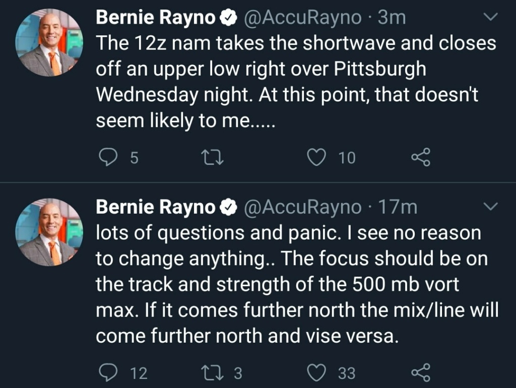
There’s been some good info shared on twitter on why this system is trending NW. Its the reasons Ray has talked about for days. I recommend watching his video for learning purposes. We’re possibly looking at a ridge over the east coast, in response to how strong the energy is within the 500mb trough.
The only way to really flatten this ridge is through blocking, and I’m not so sure the HP/50-50 position is well suited enough to do so.
Let’s see what happens on the euro, but tonight’s 00z runs (for reasons Ray just mentioned), will probably be where correction occurs IF it’s meant to be.
_________________
_______________________________________________________________________________________________________
CLICK HERE to view NJ Strong Snowstorm Classifications
rb924119 likes this post
 Re: 12/16 to 12/17 Godzilla - 1st Call Snow Map
jmanley32 wrote:huh? How does a model run show something from 1972?hyde345 wrote:nutleyblizzard wrote:Something is wonky with that Ukie run. It has a low over philly which by the way would never happen with a 1035 high up north then ends up exploding to 977mb south of LI. No other model comes close to that strength. I’m tossing it.aiannone wrote:12z UKIE takes the low over philly
That 977 low is from another storm in 1972. Look at the time stamp.
Somebody posted a map from 1972 to make a point about the Ukie. It's on another board.

hyde345- Pro Enthusiast

- Posts : 1082
Reputation : 48
Join date : 2013-01-08
Location : Hyde Park, NY
 Re: 12/16 to 12/17 Godzilla - 1st Call Snow Map
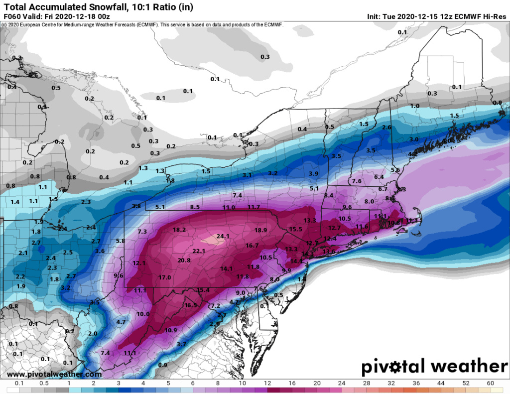
Euro did tick NW, but the cold air won out in some places. I also think some of this is sleet.


_________________
_______________________________________________________________________________________________________
CLICK HERE to view NJ Strong Snowstorm Classifications

aiannone- Senior Enthusiast - Mod

- Posts : 4815
Reputation : 92
Join date : 2013-01-07
Location : Saint James, LI (Northwest Suffolk Co.)
 Re: 12/16 to 12/17 Godzilla - 1st Call Snow Map
Here is a frame by frame look - notice how the heaviest snows are well N&W
Very little mixing issues.. city stays mostly snow as well as long island pic.twitter.com/NrGl5gHcoM
— NsfwWx (@NsfwWx) December 15, 2020
Last edited by Frank_Wx on Tue Dec 15, 2020 1:10 pm; edited 1 time in total
_________________
_______________________________________________________________________________________________________
CLICK HERE to view NJ Strong Snowstorm Classifications
heehaw453- Advanced Forecaster

- Posts : 3906
Reputation : 86
Join date : 2014-01-20
Location : Bedminster Township, PA Elevation 600' ASL
 Re: 12/16 to 12/17 Godzilla - 1st Call Snow Map
All hail the KING. 


SoulSingMG- Senior Enthusiast

- Posts : 2853
Reputation : 74
Join date : 2013-12-11
Location : Long Island City, NY
 Re: 12/16 to 12/17 Godzilla - 1st Call Snow Map
This trend in the shortwave is likely due to it finally being adequately sampled by radiosondes over N America this morning. Just goes to show how critical in-situ observations are to operational weather forecasts! https://t.co/6TTEvnDbc0 pic.twitter.com/mVVM7Dqizb
— Eric Webb (@webberweather) December 15, 2020
_________________
_______________________________________________________________________________________________________
CLICK HERE to view NJ Strong Snowstorm Classifications
 Re: 12/16 to 12/17 Godzilla - 1st Call Snow Map
heehaw453 wrote:The 12Z Euro 500mb ULL passes right over our area. It's not terrible. With the cold air in place that is very good for an 8-12" kind of snowfall. The > 1' is well west of the area. In order to get the bigger snow that ULL must be to our east. I'm just hoping it'd done correcting west at this point.
If only we can get this even 50 miles south. That would also move 700mb/850mb and reduce the impact of dry slotting.
_________________
_______________________________________________________________________________________________________
CLICK HERE to view NJ Strong Snowstorm Classifications
 Re: 12/16 to 12/17 Godzilla - 1st Call Snow Map
Frank_Wx wrote:heehaw453 wrote:The 12Z Euro 500mb ULL passes right over our area. It's not terrible. With the cold air in place that is very good for an 8-12" kind of snowfall. The > 1' is well west of the area. In order to get the bigger snow that ULL must be to our east. I'm just hoping it'd done correcting west at this point.
If only we can get this even 50 miles south. That would also move 700mb/850mb and reduce the impact of dry slotting.
Exactly Frank. It's a whole cascading effects. 50-75 miles is a reasonable adjustment at this range. I still think the block is going to work its magic.
heehaw453- Advanced Forecaster

- Posts : 3906
Reputation : 86
Join date : 2014-01-20
Location : Bedminster Township, PA Elevation 600' ASL
 Re: 12/16 to 12/17 Godzilla - 1st Call Snow Map
heehaw453 wrote:Frank_Wx wrote:heehaw453 wrote:The 12Z Euro 500mb ULL passes right over our area. It's not terrible. With the cold air in place that is very good for an 8-12" kind of snowfall. The > 1' is well west of the area. In order to get the bigger snow that ULL must be to our east. I'm just hoping it'd done correcting west at this point.
If only we can get this even 50 miles south. That would also move 700mb/850mb and reduce the impact of dry slotting.
Exactly Frank. It's a whole cascading effects. 50-75 miles is a reasonable adjustment at this range. I still think the block is going to work its magic.
That airmass outside is already feeling CRISP. Never underestimate a Québécois high.

SoulSingMG- Senior Enthusiast

- Posts : 2853
Reputation : 74
Join date : 2013-12-11
Location : Long Island City, NY
Page 6 of 12 •  1, 2, 3 ... 5, 6, 7 ... 10, 11, 12
Page 6 of 12
Permissions in this forum:
You cannot reply to topics in this forum
 Home
Home