February 1st-2nd Snowstorm Part II
+23
SoulSingMG
hyde345
SNOW MAN
MattyICE
SENJsnowman
CDF24
mmanisca
weatherwatchermom
amugs
WeatherBob
TheAresian
crippo84
algae888
bobjohnsonforthehall
dsix85
rb924119
billg315
CPcantmeasuresnow
heehaw453
jmanley32
frank 638
Irish
Frank_Wx
27 posters
Page 1 of 10
Page 1 of 10 • 1, 2, 3, 4, 5, 6, 7, 8, 9, 10 
 February 1st-2nd Snowstorm Part II
The other thread is close to exceeding its 30-page count. Let's continue the discussions here.
My preliminary thoughts:
1. No snow map just yet. There are still very important parts to this forecast that need to be ironed out. It will determine if the heaviest axis of snows will be toward NW or SE sections of this area. This also has implications to the temps along the shore and whether or not we're dealing with any type of dry slotting for a period of time.
2. The mid and upper levels of the atmosphere suggest we're staring down quite a monster. The epic snow amounts being shown on some of these models may not be far off. That is because of the slow movement and intense CCB this storm will possesses. Ratios will be 10:1 for most, but those under the CCB where the heaviest VV's are likely to be found may get 12:1 ratios.
3. The frigid air mass leading up to this storm has to help, right? I forgot the last time it was this cold right before a major snowstorm. That also means drier air and virga to start, but once it does finally begin snowing, it will accumulate FAST.
4. Yes there will be moments when this acts like a blizzard near the coast. Winds near 40 mph and heavy snow falling, that technically constitutes a blizzard. Is the criteria met for the NWS to issue blizzard warnings? I'm not so sure about that. At the end of the day, we're looking at an SLP around 995mb. Nice but not nearly as strong as other historic storms.
5. Tonight's 00z runs will give us clarity on pretty much everything (I hope), but we're already seeing agreement happen with some key features of this storm. It's the smaller details that make the difference of a foot or 3 inches for some people here!
Bring home the capocollo!!!!!
1st call snow map around 3-4pm today.
_________________
_______________________________________________________________________________________________________
CLICK HERE to view NJ Strong Snowstorm Classifications
heehaw453 likes this post
 Re: February 1st-2nd Snowstorm Part II
RGEM 6z vs 12z - confluence in Maine is stronger. Can you see it?
.png.9e6ad94f8962f5b25002bd40c10df893.png)
.png.9e6ad94f8962f5b25002bd40c10df893.png)
Last edited by Frank_Wx on Sat Jan 30, 2021 10:13 am; edited 1 time in total
_________________
_______________________________________________________________________________________________________
CLICK HERE to view NJ Strong Snowstorm Classifications
 Re: February 1st-2nd Snowstorm Part II
I've never seen a storm (I really haven't been following for a long time), that no matter how much waffling has gone on with the trending, stay centered with a bullseye around CNJ like this one.

Irish- Pro Enthusiast

- Posts : 788
Reputation : 19
Join date : 2019-01-16
Age : 45
Location : Old Bridge, NJ
 Re: February 1st-2nd Snowstorm Part II
I am excited esp for us snow lovers we have not seen this much snow for a long time
frank 638- Senior Enthusiast

- Posts : 2843
Reputation : 37
Join date : 2016-01-01
Age : 40
Location : bronx ny
 Re: February 1st-2nd Snowstorm Part II
RGEM shows a big dry slot over our area (but we still get 5-10" of snow). Biggests totals near DC then New England.


_________________
_______________________________________________________________________________________________________
CLICK HERE to view NJ Strong Snowstorm Classifications
 Re: February 1st-2nd Snowstorm Part II
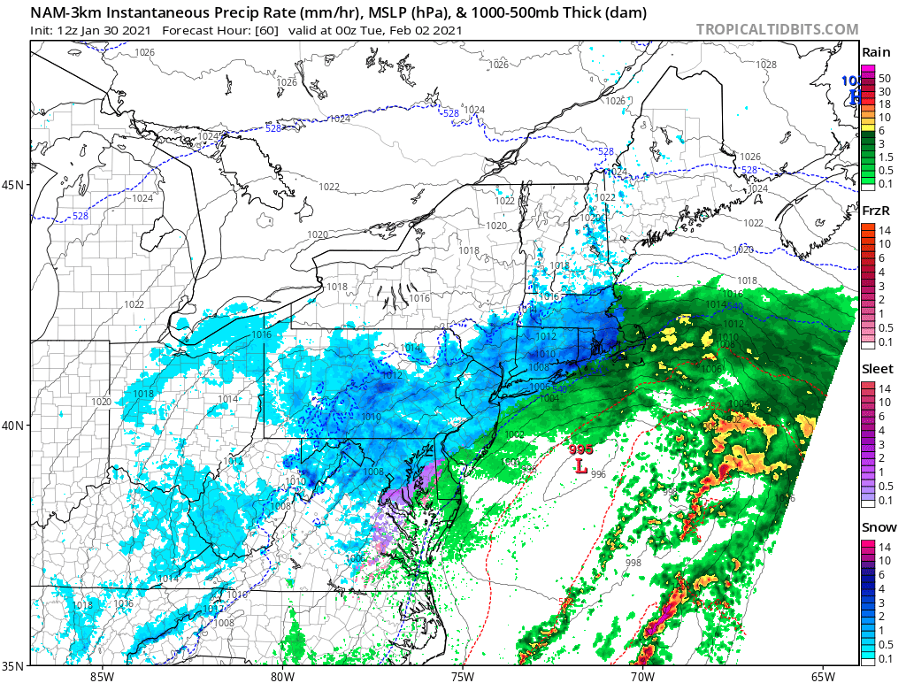
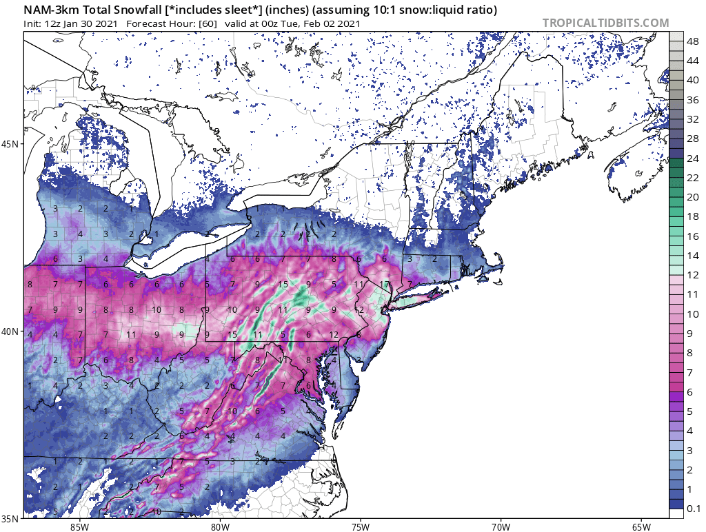
That's 12z 3km nam is nuts at HR 60 which is 00z Tues and we all have near a foot with quite a ways to go thpugh the heaviest bands came through but extrapolated out some would see 20 maybe more. 3km nam is not in good range yet which is kinda crazy this is so long duration we will be using the models to see how it ends when it's already snowing lol

jmanley32- Senior Enthusiast

- Posts : 20535
Reputation : 108
Join date : 2013-12-12
Age : 43
Location : Yonkers, NY
 Re: February 1st-2nd Snowstorm Part II
my god 40 inches in dc area!!! Me no likey this map hoping it's on its own. It's still good but far cry from other runs of models.Frank_Wx wrote:RGEM shows a big dry slot over our area (but we still get 5-10" of snow). Biggests totals near DC then New England.

jmanley32- Senior Enthusiast

- Posts : 20535
Reputation : 108
Join date : 2013-12-12
Age : 43
Location : Yonkers, NY
 Re: February 1st-2nd Snowstorm Part II
Frank_Wx wrote:RGEM shows a big dry slot over our area (but we still get 5-10" of snow). Biggests totals near DC then New England.
Goal posts may be narrowing. But consistently we see high order magnitude solutions. It just depends on the locale and what the model is seeing. Tough call ATTM.
heehaw453- Advanced Forecaster

- Posts : 3906
Reputation : 86
Join date : 2014-01-20
Location : Bedminster Township, PA Elevation 600' ASL
 Re: February 1st-2nd Snowstorm Part II
ICON has not wavered. Keeps showing obscene amounts over us


_________________
_______________________________________________________________________________________________________
CLICK HERE to view NJ Strong Snowstorm Classifications
 Re: February 1st-2nd Snowstorm Part II
frank posted the snow map for 3km nam on other thread but look at this, many have 12+ and its still snowing moderate to hard in some locations, insane!!


and correct me if im wrong but isnt the radar map 6 hrs before the snow map? so doesnt the snow map show the previous 6 hrs? that would mean even more.


and correct me if im wrong but isnt the radar map 6 hrs before the snow map? so doesnt the snow map show the previous 6 hrs? that would mean even more.

jmanley32- Senior Enthusiast

- Posts : 20535
Reputation : 108
Join date : 2013-12-12
Age : 43
Location : Yonkers, NY
 Re: February 1st-2nd Snowstorm Part II
Icon tracks H5 over SNJ and places the best vorticity directly north. This actually makes sense when you think about the tightly wound trough and 250mb jet to the north

_________________
_______________________________________________________________________________________________________
CLICK HERE to view NJ Strong Snowstorm Classifications
 Re: February 1st-2nd Snowstorm Part II
jmanley32 wrote:my god 40 inches in dc area!!! Me no likey this map hoping it's on its own. It's still good but far cry from other runs of models.Frank_Wx wrote:RGEM shows a big dry slot over our area (but we still get 5-10" of snow). Biggests totals near DC then New England.
Considering they haven't had a measurable snowfall in WDC for over a year for them to get three times their yearly average in one storm is highly unlikely. At least I hope it is.

CPcantmeasuresnow- Wx Statistician Guru

- Posts : 7274
Reputation : 230
Join date : 2013-01-07
Age : 103
Location : Eastern Orange County, NY
 Re: February 1st-2nd Snowstorm Part II
Frank_Wx wrote:Icon tracks H5 over SNJ and places the best vorticity directly north. This actually makes sense when you think about the tightly wound trough and 250mb jet to the north
That’s actually not inconsistent with last NAM run either. There was a moment in the 12z NAM where the H5 appeared to be closing off over the Delmarva then it got all sloppy and elongated as you and heehaw were discussing. So the icon may be showing what the NAM will once in better range.

billg315- Advanced Forecaster - Mod

- Posts : 4483
Reputation : 185
Join date : 2015-01-24
Age : 50
Location : Flemington, NJ
 Re: February 1st-2nd Snowstorm Part II
Through 36, 12z GFS has lower heights due to stronger confluence vs 6z
_________________
_______________________________________________________________________________________________________
CLICK HERE to view NJ Strong Snowstorm Classifications
 Re: February 1st-2nd Snowstorm Part II
Madonne
12z

6z

12z

6z

_________________
_______________________________________________________________________________________________________
CLICK HERE to view NJ Strong Snowstorm Classifications
 Re: February 1st-2nd Snowstorm Part II
GFS midday monday its barely snowing in NYC area....and DC is seeing major blitzing.

jmanley32- Senior Enthusiast

- Posts : 20535
Reputation : 108
Join date : 2013-12-12
Age : 43
Location : Yonkers, NY
 Re: February 1st-2nd Snowstorm Part II
GFS looks completely lost to me, honestly.
rb924119- Meteorologist

- Posts : 6928
Reputation : 194
Join date : 2013-02-06
Age : 32
Location : Greentown, Pa
 Re: February 1st-2nd Snowstorm Part II
rb924119 wrote:GFS looks completely lost to me, honestly.
Isn't that usually the case?

Irish- Pro Enthusiast

- Posts : 788
Reputation : 19
Join date : 2019-01-16
Age : 45
Location : Old Bridge, NJ
 Re: February 1st-2nd Snowstorm Part II
i hope so it looks like the rgem that had DC in 3 ftrb924119 wrote:GFS looks completely lost to me, honestly.

jmanley32- Senior Enthusiast

- Posts : 20535
Reputation : 108
Join date : 2013-12-12
Age : 43
Location : Yonkers, NY
 Re: February 1st-2nd Snowstorm Part II
Irish wrote:rb924119 wrote:GFS looks completely lost to me, honestly.
Isn't that usually the case?
Yes lol
rb924119- Meteorologist

- Posts : 6928
Reputation : 194
Join date : 2013-02-06
Age : 32
Location : Greentown, Pa
 Re: February 1st-2nd Snowstorm Part II
Another trend I am seeing is the primary low hanging on longer
That gives us better WAA snows, but it does develop the secondary more east than what we saw yesterday
That gives us better WAA snows, but it does develop the secondary more east than what we saw yesterday
_________________
_______________________________________________________________________________________________________
CLICK HERE to view NJ Strong Snowstorm Classifications
 Re: February 1st-2nd Snowstorm Part II
rb924119 wrote:GFS looks completely lost to me, honestly.
Funny I felt that way with the RGEM/NAM
H5 and surface not quite matching up
_________________
_______________________________________________________________________________________________________
CLICK HERE to view NJ Strong Snowstorm Classifications
 Re: February 1st-2nd Snowstorm Part II
GFS has me at 5 inches....hahaha i dont buy that for a second sorry, and thats not wishcasting, not one model shows that.

jmanley32- Senior Enthusiast

- Posts : 20535
Reputation : 108
Join date : 2013-12-12
Age : 43
Location : Yonkers, NY
 Re: February 1st-2nd Snowstorm Part II

_________________
_______________________________________________________________________________________________________
CLICK HERE to view NJ Strong Snowstorm Classifications
 Re: February 1st-2nd Snowstorm Part II
Frank- are the primary heavy snows a result of the second low? And, a more easterly track indicative of the coast potentially jackpotting in our area?
dsix85- Pro Enthusiast

- Posts : 349
Reputation : 8
Join date : 2014-01-01
Location : New York
Page 1 of 10 • 1, 2, 3, 4, 5, 6, 7, 8, 9, 10 
Page 1 of 10
Permissions in this forum:
You cannot reply to topics in this forum|
|
|

 Home
Home