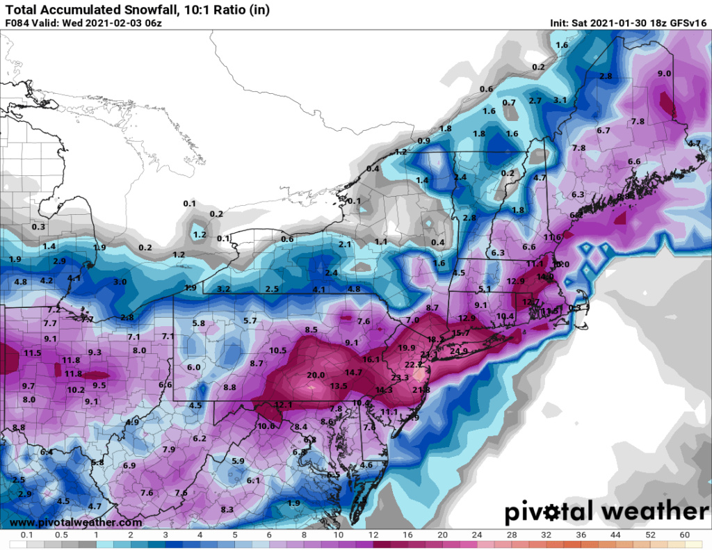
February 1st-2nd Snowstorm Part II
+23
SoulSingMG
hyde345
SNOW MAN
MattyICE
SENJsnowman
CDF24
mmanisca
weatherwatchermom
amugs
WeatherBob
TheAresian
crippo84
algae888
bobjohnsonforthehall
dsix85
rb924119
billg315
CPcantmeasuresnow
heehaw453
jmanley32
frank 638
Irish
Frank_Wx
27 posters
Page 9 of 10
Page 9 of 10 •  1, 2, 3, 4, 5, 6, 7, 8, 9, 10
 Re: February 1st-2nd Snowstorm Part II
jmanley32 wrote:SENJsnowman wrote:Looks like a significant increase snow totals throughout Ocean County from 00z-06z overnight. One more tick se which I think can still hold serve for everyone else, and we back in double digit totals ALL THE WAY TO BARNEGAT!!!
LAR-RY!! LAR-RY!! Let’s do this man! Skidoo, you too up there in the TR!!
Yeah, next tick will be nw. lol
did you mean to post this twice? it was posted several posts back fyi.
Nope...no idea how that happened. lol Scroll up and look what I did to the second one. It took up WAY too much of my time just now.
10"+!!! From Yonkers to Bayville!! Bedminster to Wading River!! Cranford to Orange County NY!!
SENJsnowman- Senior Enthusiast

- Posts : 1189
Join date : 2017-01-06
 Re: February 1st-2nd Snowstorm Part II
18z shifted a good amount north, shore peeps arent go be happy if this is true.
jmanley32- Senior Enthusiast

- Posts : 20535
Join date : 2013-12-12
GreyBeard- Senior Enthusiast

- Posts : 725
Reputation : 34
Join date : 2014-02-12
Location : eastern nassau county
RJB8525 likes this post
 Re: February 1st-2nd Snowstorm Part II
This is shaping up to be a kegger event.
Yay!
Yay!

dkodgis- Senior Enthusiast

- Posts : 2560
Reputation : 98
Join date : 2013-12-29
rb924119 likes this post
 Re: February 1st-2nd Snowstorm Part II
SENJsnowman wrote:jmanley32 wrote:SENJsnowman wrote:Looks like a significant increase snow totals throughout Ocean County from 00z-06z overnight. One more tick se which I think can still hold serve for everyone else, and we back in double digit totals ALL THE WAY TO BARNEGAT!!!
LAR-RY!! LAR-RY!! Let’s do this man! Skidoo, you too up there in the TR!!
Yeah, next tick will be nw. lol
did you mean to post this twice? it was posted several posts back fyi.
Nope...no idea how that happened. lol Scroll up and look what I did to the second one. It took up WAY too much of my time just now.
10"+!!! From Yonkers to Bayville!! Bedminster to Wading River!! Cranford to Orange County NY!!
If it happens again, hit edit, highlight the whole post, right click, cut, then just put any letter in there. I think we lose the ability to delete if someone posts after you. Try it on the one you put the lines through.
Happy trails!
Last edited by GreyBeard on Sat Jan 30, 2021 5:49 pm; edited 1 time in total
GreyBeard- Senior Enthusiast

- Posts : 725
Reputation : 34
Join date : 2014-02-12
Location : eastern nassau county
 Re: February 1st-2nd Snowstorm Part II
I wanna see a snow map from RB!!!!

WeatherBob- Meteorologist

- Posts : 683
Reputation : 83
Join date : 2013-12-13
Location : Caldwell, NJ - NW Essex County - Altitude 500 FT
Irish likes this post
 Re: February 1st-2nd Snowstorm Part II
Frank, where is your snow map?

WeatherBob- Meteorologist

- Posts : 683
Reputation : 83
Join date : 2013-12-13
Location : Caldwell, NJ - NW Essex County - Altitude 500 FT
 Re: February 1st-2nd Snowstorm Part II
WeatherBob wrote:I wanna see a snow map from RB!!!!
Frank got so excited putting his together he had a heart attack.

Irish- Pro Enthusiast

- Posts : 788
Reputation : 19
Join date : 2019-01-16
Age : 45
Location : Old Bridge, NJ
 Re: February 1st-2nd Snowstorm Part II
I've learned and Frank works hard so this is totally joking. Arpund 4pm means about 6 hrs later.

jmanley32- Senior Enthusiast

- Posts : 20535
Reputation : 108
Join date : 2013-12-12
Age : 43
Location : Yonkers, NY
rb924119 and brownie like this post
 Re: February 1st-2nd Snowstorm Part II
He might have od'd on the copocollo.
GreyBeard- Senior Enthusiast

- Posts : 725
Reputation : 34
Join date : 2014-02-12
Location : eastern nassau county
rb924119 and dsix85 like this post
 Re: February 1st-2nd Snowstorm Part II
He did also say he wasn't available this weekend to zoom so he is prolly busy.

jmanley32- Senior Enthusiast

- Posts : 20535
Reputation : 108
Join date : 2013-12-12
Age : 43
Location : Yonkers, NY
 Re: February 1st-2nd Snowstorm Part II
no I don’t lol But My crazy Italian uncle he owns a pizzeria in the Bronx no rain no snow storm or hurricanes will stop him from working
frank 638- Senior Enthusiast

- Posts : 2843
Reputation : 37
Join date : 2016-01-01
Age : 40
Location : bronx ny
 Re: February 1st-2nd Snowstorm Part II
WeatherBob wrote:I wanna see a snow map from RB!!!!
I’m not gonna be able to make one......again
rb924119- Meteorologist

- Posts : 6928
Reputation : 194
Join date : 2013-02-06
Age : 32
Location : Greentown, Pa

CPcantmeasuresnow- Wx Statistician Guru

- Posts : 7274
Reputation : 230
Join date : 2013-01-07
Age : 103
Location : Eastern Orange County, NY
Irish likes this post
 Re: February 1st-2nd Snowstorm Part II
Umm guys, the rgem just went nuts and stalled till wed!!!

jmanley32- Senior Enthusiast

- Posts : 20535
Reputation : 108
Join date : 2013-12-12
Age : 43
Location : Yonkers, NY

jmanley32- Senior Enthusiast

- Posts : 20535
Reputation : 108
Join date : 2013-12-12
Age : 43
Location : Yonkers, NY

jmanley32- Senior Enthusiast

- Posts : 20535
Reputation : 108
Join date : 2013-12-12
Age : 43
Location : Yonkers, NY
 Re: February 1st-2nd Snowstorm Part II
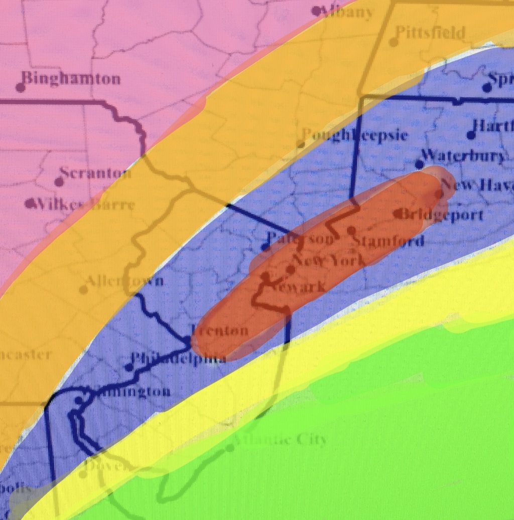
I was going to wait until Frank posted his snow map before posting this for three reasons:
1.) It’s his Forum, so I defer to him on almost everything;
2.) His map will be of higher quality (I’m sure JMan will reference his daughter’s water colors again lol)
3.) Frank’s map will come with more detailed analysis.
But since Frank’s map is a bit delayed I’ll throw mine out there to chew on as an appetizer before his main course arrives.
P.s I still remember stealing this base map from rb in 2018. Thanks rb! Much better than the one I used back in December.
So here goes:
Green: Mostly Rain. Snow at start and end but so much more rain as to render any accumulation marginal. But watch winds and coastal flooding.
Yellow: 5-10”. Snow will have some sleet and rain mix in at times in the middle of the storm, especially close to the shore, which will keep totals down a tad. If you get less mixing you’ll be closer to 10”; more and you’ll be near 5”.
Blue/Purple: 10-15”. Heavy snow throughout. Maybe a lull during transfer to coastal early Monday, but will pick up again as coastal takes over.
Red (in middle of Blue): 15-20” in jackpot zone. CCB band crushes it.
Orange: 5-10” of snow. Good steady snow but just a tad away from the heaviest bands.
Pink: 3-5” of snow. I just think this is going to be where the cutoff is for the really heavy snow from the coastal. This area may benefit more from the WWA out front which could boost this total a bit.


billg315- Advanced Forecaster - Mod

- Posts : 4483
Reputation : 185
Join date : 2015-01-24
Age : 50
Location : Flemington, NJ
sroc4, rb924119, Grselig, brownie, weatherwatchermom and phil155 like this post
 Re: February 1st-2nd Snowstorm Part II
If you can just expand that red band a tad west, that would be nice.! Thanks for posting.
Grselig- Senior Enthusiast

- Posts : 1408
Reputation : 140
Join date : 2013-03-04
Age : 54
Location : Wayne NJ
 Re: February 1st-2nd Snowstorm Part II
thank you!billg315 wrote:I was going to wait until Frank posted his snow map before posting this for three reasons:
1.) It’s his Forum, so I defer to him on almost everything;
2.) His map will be of higher quality (I’m sure JMan will reference his daughter’s water colors again lol)
3.) Frank’s map will come with more detailed analysis.
But since Frank’s map is a bit delayed I’ll throw mine out there to chew on as an appetizer before his main course arrives.
P.s I still remember stealing this base map from rb in 2018. Thanks rb! Much better than the one I used back in December.
So here goes:
Green: Mostly Rain. Snow at start and end but so much more rain as to render any accumulation marginal. But watch winds and coastal flooding.
Yellow: 5-10”. Snow will have some sleet and rain mix in at times in the middle of the storm, especially close to the shore, which will keep totals down a tad. If you get less mixing you’ll be closer to 10”; more and you’ll be near 5”.
Blue/Purple: 10-15”. Heavy snow throughout. Maybe a lull during transfer to coastal early Monday, but will pick up again as coastal takes over.
Red (in middle of Blue): 15-20” in jackpot zone. CCB band crushes it.
Orange: 5-10” of snow. Good steady snow but just a tad away from the heaviest bands.
Pink: 3-5” of snow. I just think this is going to be where the cutoff is for the really heavy snow from the coastal. This area may benefit more from the WWA out front which could boost this total a bit.

weatherwatchermom- Senior Enthusiast

- Posts : 3793
Reputation : 78
Join date : 2014-11-25
Location : Hazlet Township, NJ
 Re: February 1st-2nd Snowstorm Part II
Thank you so much for your snow map And I am happy to be in the jackpot zone we haven’t seen this much snow for a long long timebillg315 wrote:I was going to wait until Frank posted his snow map before posting this for three reasons:
1.) It’s his Forum, so I defer to him on almost everything;
2.) His map will be of higher quality (I’m sure JMan will reference his daughter’s water colors again lol)
3.) Frank’s map will come with more detailed analysis.
But since Frank’s map is a bit delayed I’ll throw mine out there to chew on as an appetizer before his main course arrives.
P.s I still remember stealing this base map from rb in 2018. Thanks rb! Much better than the one I used back in December.
So here goes:
Green: Mostly Rain. Snow at start and end but so much more rain as to render any accumulation marginal. But watch winds and coastal flooding.
Yellow: 5-10”. Snow will have some sleet and rain mix in at times in the middle of the storm, especially close to the shore, which will keep totals down a tad. If you get less mixing you’ll be closer to 10”; more and you’ll be near 5”.
Blue/Purple: 10-15”. Heavy snow throughout. Maybe a lull during transfer to coastal early Monday, but will pick up again as coastal takes over.
Red (in middle of Blue): 15-20” in jackpot zone. CCB band crushes it.
Orange: 5-10” of snow. Good steady snow but just a tad away from the heaviest bands.
Pink: 3-5” of snow. I just think this is going to be where the cutoff is for the really heavy snow from the coastal. This area may benefit more from the WWA out front which could boost this total a bit.
frank 638- Senior Enthusiast

- Posts : 2843
Reputation : 37
Join date : 2016-01-01
Age : 40
Location : bronx ny
 Re: February 1st-2nd Snowstorm Part II
I don't see any red, or do you have the orange on top of it?
GreyBeard- Senior Enthusiast

- Posts : 725
Reputation : 34
Join date : 2014-02-12
Location : eastern nassau county
 Re: February 1st-2nd Snowstorm Part II
billg315 wrote:I was going to wait until Frank posted his snow map before posting this for three reasons:
1.) It’s his Forum, so I defer to him on almost everything;
2.) His map will be of higher quality (I’m sure JMan will reference his daughter’s water colors again lol)
3.) Frank’s map will come with more detailed analysis.
But since Frank’s map is a bit delayed I’ll throw mine out there to chew on as an appetizer before his main course arrives.
P.s I still remember stealing this base map from rb in 2018. Thanks rb! Much better than the one I used back in December.
So here goes:
Green: Mostly Rain. Snow at start and end but so much more rain as to render any accumulation marginal. But watch winds and coastal flooding.
Yellow: 5-10”. Snow will have some sleet and rain mix in at times in the middle of the storm, especially close to the shore, which will keep totals down a tad. If you get less mixing you’ll be closer to 10”; more and you’ll be near 5”.
Blue/Purple: 10-15”. Heavy snow throughout. Maybe a lull during transfer to coastal early Monday, but will pick up again as coastal takes over.
Red (in middle of Blue): 15-20” in jackpot zone. CCB band crushes it.
Orange: 5-10” of snow. Good steady snow but just a tad away from the heaviest bands.
Pink: 3-5” of snow. I just think this is going to be where the cutoff is for the really heavy snow from the coastal. This area may benefit more from the WWA out front which could boost this total a bit.
I think it’s safe to say that he doesn’t mind if other people post maps/forecasts lol in fact, while I can’t speak for the man himself, I would think he welcomes it, as would the moderators, so long as there’s honest effort/quality content to them. A bunch of us make maps all the time, that’s where the other 50% of the fun comes in haha I like your map, but definitely want to pick your brain a bit later on when I get out of work (in a friendly way, of course)
rb924119- Meteorologist

- Posts : 6928
Reputation : 194
Join date : 2013-02-06
Age : 32
Location : Greentown, Pa
 Re: February 1st-2nd Snowstorm Part II
GreyBeard wrote:I don't see any red, or do you have the orange on top of it?
The red has an orange hue, but didn't want it confused with the lighter orange to the west. Essentially the red area is that blob you see in the middle of the blue/purple.

billg315- Advanced Forecaster - Mod

- Posts : 4483
Reputation : 185
Join date : 2015-01-24
Age : 50
Location : Flemington, NJ
GreyBeard likes this post
 Re: February 1st-2nd Snowstorm Part II
Amy Freeze has me up in northern Orange county with 3-6 inches plus mixing/rain. As Mugs says: “You get what you get and you like what you get”

dkodgis- Senior Enthusiast

- Posts : 2560
Reputation : 98
Join date : 2013-12-29
 Re: February 1st-2nd Snowstorm Part II
You can definitely pick my brain. Some who have done so have found not much to be found there. LOL. I tend to learn far more from picking your brain, so that will probably be where that conversation goes. haharb924119 wrote:billg315 wrote:I was going to wait until Frank posted his snow map before posting this for three reasons:
1.) It’s his Forum, so I defer to him on almost everything;
2.) His map will be of higher quality (I’m sure JMan will reference his daughter’s water colors again lol)
3.) Frank’s map will come with more detailed analysis.
But since Frank’s map is a bit delayed I’ll throw mine out there to chew on as an appetizer before his main course arrives.
P.s I still remember stealing this base map from rb in 2018. Thanks rb! Much better than the one I used back in December.
So here goes:
Green: Mostly Rain. Snow at start and end but so much more rain as to render any accumulation marginal. But watch winds and coastal flooding.
Yellow: 5-10”. Snow will have some sleet and rain mix in at times in the middle of the storm, especially close to the shore, which will keep totals down a tad. If you get less mixing you’ll be closer to 10”; more and you’ll be near 5”.
Blue/Purple: 10-15”. Heavy snow throughout. Maybe a lull during transfer to coastal early Monday, but will pick up again as coastal takes over.
Red (in middle of Blue): 15-20” in jackpot zone. CCB band crushes it.
Orange: 5-10” of snow. Good steady snow but just a tad away from the heaviest bands.
Pink: 3-5” of snow. I just think this is going to be where the cutoff is for the really heavy snow from the coastal. This area may benefit more from the WWA out front which could boost this total a bit.
I think it’s safe to say that he doesn’t mind if other people post maps/forecasts lol in fact, while I can’t speak for the man himself, I would think he welcomes it, as would the moderators, so long as there’s honest effort/quality content to them. A bunch of us make maps all the time, that’s where the other 50% of the fun comes in haha I like your map, but definitely want to pick your brain a bit later on when I get out of work (in a friendly way, of course)

billg315- Advanced Forecaster - Mod

- Posts : 4483
Reputation : 185
Join date : 2015-01-24
Age : 50
Location : Flemington, NJ
 Re: February 1st-2nd Snowstorm Part II
billg315 wrote:GreyBeard wrote:I don't see any red, or do you have the orange on top of it?
The red has an orange hue, but didn't want it confused with the lighter orange to the west. Essentially the red area is that blob you see in the middle of the blue/purple.
My fault, my old eyes playing tricks on me. The shade of orange was so subtle to me I thought the blue was sandwiched between 2 yellows with orange inbetween.I've got no complaints as you've got me in the red.

GreyBeard- Senior Enthusiast

- Posts : 725
Reputation : 34
Join date : 2014-02-12
Location : eastern nassau county
Page 9 of 10 •  1, 2, 3, 4, 5, 6, 7, 8, 9, 10
Page 9 of 10
Permissions in this forum:
You cannot reply to topics in this forum|
|
|

 Home
Home
