
 Search
February 1st-2nd Snowstorm Part II
Page 3 of 10 •  1, 2, 3, 4, 5, 6, 7, 8, 9, 10
 ![]()
Re: February 1st-2nd Snowstorm Part II
![]() by billg315 Sat Jan 30, 2021 11:36 am
by billg315 Sat Jan 30, 2021 11:36 am
TheAresian wrote:To the most knowledgeable members of the board, which of these models makes sense as opposed to which ones are showing us lots of nice numbers and pretty colors? We usually throw the GFS out, discount the NAM outside of maybe 48 hrs and we've yet to hear from King Euro the 12zth. Is one of these other models suddenly a beacon of previously hidden wisdom?
Right now I think its just a matter at looking at a blend of all the models and seeing where they are consistent, and not getting too bogged down (just yet) in the details of where exactly the heaviest snowfall will be. There seems to be general consensus on this being a big snowfall (5"-plus) for the almost the entire area, but it's that large jackpot zone (10" plus) that is hard to nail down. rb has been feeling a northward trend and overnight that seemed to possibly be taking shape, but then the 12z NAM came back south, and the other models have seemed to not get too far north at any point. I still think the heaviest snows will be oriented from just north of Philadelphia to just south of NYC then out onto Long Island with still significant snow 20-30 miles just north and south of that jackpot strip. The areas I'm not sure of? New Jersey south of Route 70 and east of route 206 and the northern tier of PA and southern tier of NY across and up to Albany. But that's a guess. Details still up in the air as I said.
billg315- Advanced Forecaster - Mod

- Posts : 4483
Join date : 2015-01-24
Re: February 1st-2nd Snowstorm Part II
![]() by heehaw453 Sat Jan 30, 2021 11:37 am
by heehaw453 Sat Jan 30, 2021 11:37 am
algae888 wrote:Yes heehaw some places are going to be buried. I don't think we will know until Monday morning unfortunately
Algae I think you're right. I think it's going to be impossible to know jackpot areas. But large scale event over a large scope seems likely. Frank has his work cut out for him. LOL! Kudos Frank for trying to figure it out.
heehaw453- Advanced Forecaster

- Posts : 3906
Join date : 2014-01-20
Re: February 1st-2nd Snowstorm Part II
![]() by jmanley32 Sat Jan 30, 2021 11:39 am
by jmanley32 Sat Jan 30, 2021 11:39 am
This could be a recipe for a major disaster of a commute if we do not know until its upon us and the pros do not put out enough info, hopefully they will err cautiously and warn the upper extent here. Monday afternoon could be a nightmare.algae888 wrote:Yes heehaw some places are going to be buried. I don't think we will know until Monday morning unfortunately

jmanley32- Senior Enthusiast

- Posts : 20535
Reputation : 108
Join date : 2013-12-12
Age : 43
Location : Yonkers, NY
Re: February 1st-2nd Snowstorm Part II
![]() by algae888 Sat Jan 30, 2021 11:58 am
by algae888 Sat Jan 30, 2021 11:58 am

algae888- Advanced Forecaster
- Posts : 5311
Reputation : 46
Join date : 2013-02-05
Age : 62
Location : mt. vernon, new york
Re: February 1st-2nd Snowstorm Part II
![]() by algae888 Sat Jan 30, 2021 11:59 am
by algae888 Sat Jan 30, 2021 11:59 am
algae888- Advanced Forecaster
- Posts : 5311
Reputation : 46
Join date : 2013-02-05
Age : 62
Location : mt. vernon, new york
Re: February 1st-2nd Snowstorm Part II
![]() by TheAresian Sat Jan 30, 2021 12:02 pm
by TheAresian Sat Jan 30, 2021 12:02 pm
TheAresian- Senior Enthusiast
- Posts : 145
Reputation : 10
Join date : 2019-11-13
Location : Painted Post, NY
Judy Margolis likes this post
Re: February 1st-2nd Snowstorm Part II
![]() by heehaw453 Sat Jan 30, 2021 12:12 pm
by heehaw453 Sat Jan 30, 2021 12:12 pm

heehaw453- Advanced Forecaster
- Posts : 3906
Reputation : 86
Join date : 2014-01-20
Location : Bedminster Township, PA Elevation 600' ASL
Re: February 1st-2nd Snowstorm Part II
![]() by Irish Sat Jan 30, 2021 12:14 pm
by Irish Sat Jan 30, 2021 12:14 pm
heehaw453 wrote:We've been talking about the comma head structure for moisture transports. This is how you really crank CCB. But you must have cold air in place to really max out the rates. Those kind of events are very special events.
That looks crushing and once again right across CNJ. What is that showing, not snowfall amounts, right?

Irish- Pro Enthusiast

- Posts : 788
Reputation : 19
Join date : 2019-01-16
Age : 45
Location : Old Bridge, NJ
Re: February 1st-2nd Snowstorm Part II
![]() by CPcantmeasuresnow Sat Jan 30, 2021 12:29 pm
by CPcantmeasuresnow Sat Jan 30, 2021 12:29 pm
I think by 2AM tonight after all the 0Z's are in we will have our generaL answers. However in my long history of weather watching I've rarely seen the models nail down where the heaviest bands will setup even 6 hours in advance. That's always the big wildcard, and in a storm like this it will be the difference between 8 inches and 24 inches in a 40 mile area.
Also still no Winter Storm watch here, which shows the NWS still has no clue what to think.

CPcantmeasuresnow- Wx Statistician Guru

- Posts : 7274
Reputation : 230
Join date : 2013-01-07
Age : 103
Location : Eastern Orange County, NY
Re: February 1st-2nd Snowstorm Part II
![]() by TheAresian Sat Jan 30, 2021 12:31 pm
by TheAresian Sat Jan 30, 2021 12:31 pm
TheAresian- Senior Enthusiast
- Posts : 145
Reputation : 10
Join date : 2019-11-13
Location : Painted Post, NY
CPcantmeasuresnow likes this post
Re: February 1st-2nd Snowstorm Part II
![]() by Irish Sat Jan 30, 2021 12:35 pm
by Irish Sat Jan 30, 2021 12:35 pm
CPcantmeasuresnow wrote:TWC app, not exactly the place to go for accurate forecasts, had me at 3-7 inches last night and 10-17 inches now 12 hours later. Two days before the event I am still preparing mentally for 3 inches or two feet on some models.
I think by 2AM tonight after all the 0Z's are in we will have our generaL answers. However in my long history of weather watching I've rarely seen the models nail down where the heaviest bands will setup even 6 hours in advance. That's always the big wildcard, and in a storm like this it will be the difference between 8 inches and 24 inches in a 40 mile area.
Also still no Winter Storm watch here, which shows the NWS still has no clue what to think.
Agreed, I will say however, that TWC has predicted as low as 6-12 and as high as just under 2 feet for me. So, in their opinion, it's coming they just don't know if we'll be the exact bullseye or just outside it. Right now they have me at 3-5 Sunday night, 8-12 Monday day, 1-3 Monday night, and an inch on Tuesday for a range of 13-21. We shall see...
Irish- Pro Enthusiast
- Posts : 788
Reputation : 19
Join date : 2019-01-16
Age : 45
Location : Old Bridge, NJ
Re: February 1st-2nd Snowstorm Part II
![]() by WeatherBob Sat Jan 30, 2021 12:37 pm
by WeatherBob Sat Jan 30, 2021 12:37 pm

WeatherBob- Meteorologist

- Posts : 683
Reputation : 83
Join date : 2013-12-13
Location : Caldwell, NJ - NW Essex County - Altitude 500 FT
CPcantmeasuresnow and WeatherBob like this post
Re: February 1st-2nd Snowstorm Part II
![]() by Frank_Wx Sat Jan 30, 2021 12:42 pm
by Frank_Wx Sat Jan 30, 2021 12:42 pm


The 700mb low tracks south then off the coast and keeps our air moist. Risk of dry slotting for central/eastern LI into portions of SNE exist, though.
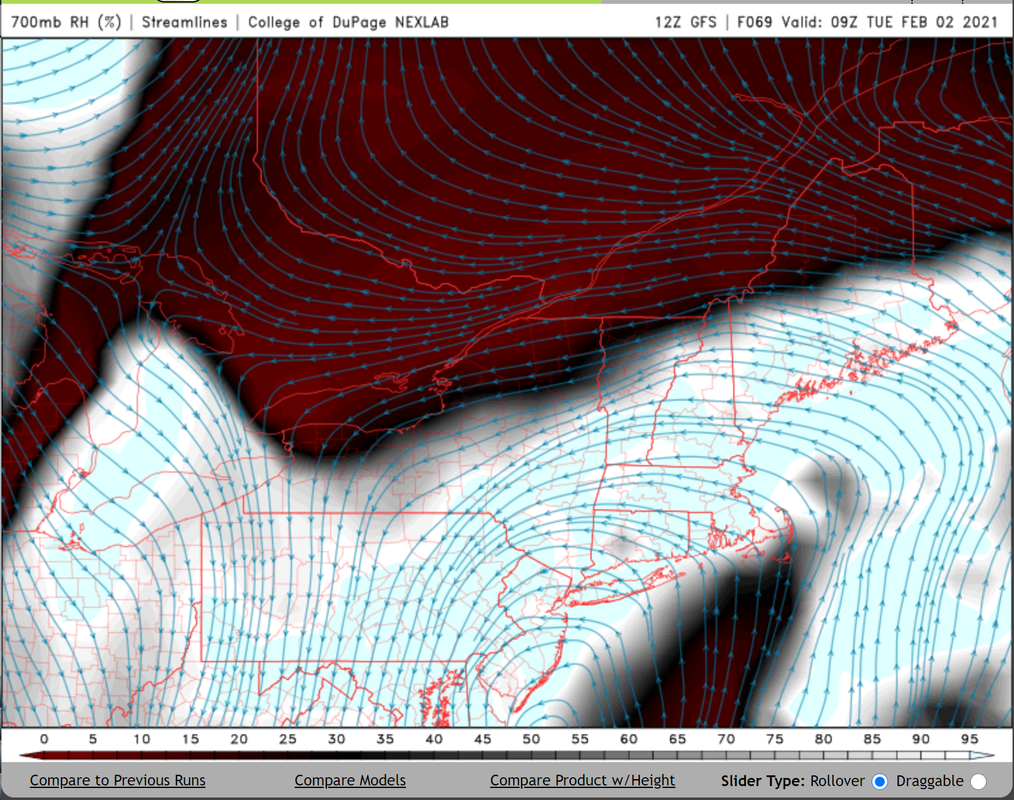
What is too late to develop is the upper level jet streak in the NW Atlantic. I would like to see it more west than where the GFS had it.
_________________
_______________________________________________________________________________________________________
CLICK HERE to view NJ Strong Snowstorm Classifications

Frank_Wx- Godzilla Seeker

- Posts : 21305
Reputation : 328
Join date : 2013-01-05
Age : 32
Location : Jersey City, NJ -

Re: February 1st-2nd Snowstorm Part II
![]() by Frank_Wx Sat Jan 30, 2021 12:50 pm
by Frank_Wx Sat Jan 30, 2021 12:50 pm
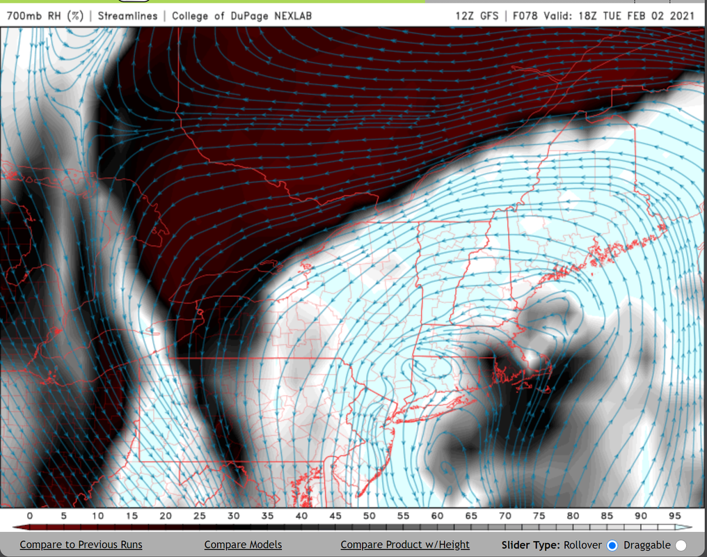
This was 00z last night


_________________
_______________________________________________________________________________________________________
CLICK HERE to view NJ Strong Snowstorm Classifications
Frank_Wx- Godzilla Seeker
- Posts : 21305
Reputation : 328
Join date : 2013-01-05
Age : 32
Location : Jersey City, NJ -
Re: February 1st-2nd Snowstorm Part II
![]() by rb924119 Sat Jan 30, 2021 12:55 pm
by rb924119 Sat Jan 30, 2021 12:55 pm
rb924119- Meteorologist
- Posts : 6928
Reputation : 194
Join date : 2013-02-06
Age : 32
Location : Greentown, Pa
Re: February 1st-2nd Snowstorm Part II
![]() by Irish Sat Jan 30, 2021 12:56 pm
by Irish Sat Jan 30, 2021 12:56 pm
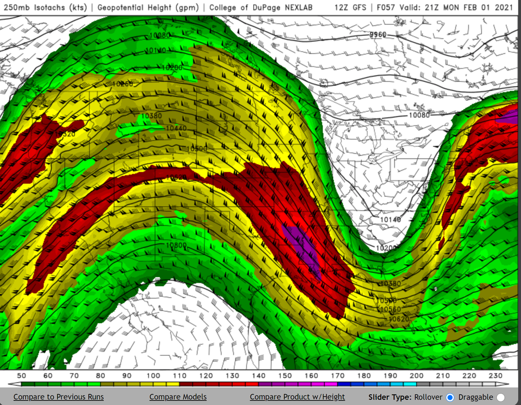
rb924119 wrote:EURO making changes aloft again. Higher heights out front, relaxed confluence. Think it’s coming further north. Let’s see.
NO!!
Irish- Pro Enthusiast
- Posts : 788
Reputation : 19
Join date : 2019-01-16
Age : 45
Location : Old Bridge, NJ
Re: February 1st-2nd Snowstorm Part II
![]() by rb924119 Sat Jan 30, 2021 1:00 pm
by rb924119 Sat Jan 30, 2021 1:00 pm
rb924119- Meteorologist
- Posts : 6928
Reputation : 194
Join date : 2013-02-06
Age : 32
Location : Greentown, Pa
Re: February 1st-2nd Snowstorm Part II
![]() by Frank_Wx Sat Jan 30, 2021 1:00 pm
by Frank_Wx Sat Jan 30, 2021 1:00 pm
rb924119 wrote:EURO making changes aloft again. Higher heights out front, relaxed confluence. Think it’s coming further north. Let’s see.
Gunna have to disagree
.gif.0f7b1624c17860e4523ef29d58b0a4f5.gif)
_________________
_______________________________________________________________________________________________________
CLICK HERE to view NJ Strong Snowstorm Classifications
Frank_Wx- Godzilla Seeker
- Posts : 21305
Reputation : 328
Join date : 2013-01-05
Age : 32
Location : Jersey City, NJ -
Re: February 1st-2nd Snowstorm Part II
![]() by billg315 Sat Jan 30, 2021 1:01 pm
by billg315 Sat Jan 30, 2021 1:01 pm

billg315- Advanced Forecaster - Mod
- Posts : 4483
Reputation : 185
Join date : 2015-01-24
Age : 50
Location : Flemington, NJ
Re: February 1st-2nd Snowstorm Part II
![]() by rb924119 Sat Jan 30, 2021 1:01 pm
by rb924119 Sat Jan 30, 2021 1:01 pm
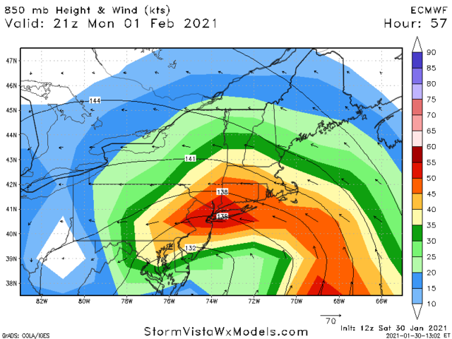
Frank_Wx wrote:rb924119 wrote:EURO making changes aloft again. Higher heights out front, relaxed confluence. Think it’s coming further north. Let’s see.
Gunna have to disagree
See my follow-up post lol same page, brotha
rb924119- Meteorologist
- Posts : 6928
Reputation : 194
Join date : 2013-02-06
Age : 32
Location : Greentown, Pa
Re: February 1st-2nd Snowstorm Part II
![]() by billg315 Sat Jan 30, 2021 1:01 pm
by billg315 Sat Jan 30, 2021 1:01 pm
rb924119 wrote:EURO making changes aloft again. Higher heights out front, relaxed confluence. Think it’s coming further north. Let’s see.
Seems a smidge south to me so far.
billg315- Advanced Forecaster - Mod
- Posts : 4483
Reputation : 185
Join date : 2015-01-24
Age : 50
Location : Flemington, NJ
Re: February 1st-2nd Snowstorm Part II
![]() by Frank_Wx Sat Jan 30, 2021 1:02 pm
by Frank_Wx Sat Jan 30, 2021 1:02 pm
.gif.6b3b81517c9ea4179d3aaaa4b71585de.gif)
_________________
_______________________________________________________________________________________________________
CLICK HERE to view NJ Strong Snowstorm Classifications
Frank_Wx- Godzilla Seeker
- Posts : 21305
Reputation : 328
Join date : 2013-01-05
Age : 32
Location : Jersey City, NJ -
Re: February 1st-2nd Snowstorm Part II
![]() by rb924119 Sat Jan 30, 2021 1:02 pm
by rb924119 Sat Jan 30, 2021 1:02 pm
rb924119- Meteorologist
- Posts : 6928
Reputation : 194
Join date : 2013-02-06
Age : 32
Location : Greentown, Pa
Re: February 1st-2nd Snowstorm Part II
![]() by Frank_Wx Sat Jan 30, 2021 1:03 pm
by Frank_Wx Sat Jan 30, 2021 1:03 pm
_________________
_______________________________________________________________________________________________________
CLICK HERE to view NJ Strong Snowstorm Classifications
Frank_Wx- Godzilla Seeker
- Posts : 21305
Reputation : 328
Join date : 2013-01-05
Age : 32
Location : Jersey City, NJ -
Irish likes this post
Re: February 1st-2nd Snowstorm Part II
![]() by Frank_Wx Sat Jan 30, 2021 1:03 pm
by Frank_Wx Sat Jan 30, 2021 1:03 pm

_________________
_______________________________________________________________________________________________________
CLICK HERE to view NJ Strong Snowstorm Classifications
Frank_Wx- Godzilla Seeker
- Posts : 21305
Reputation : 328
Join date : 2013-01-05
Age : 32
Location : Jersey City, NJ -
Angela0621 likes this post
Re: February 1st-2nd Snowstorm Part II
![]() by Frank_Wx Sat Jan 30, 2021 1:04 pm
by Frank_Wx Sat Jan 30, 2021 1:04 pm
_________________
_______________________________________________________________________________________________________
CLICK HERE to view NJ Strong Snowstorm Classifications
Frank_Wx- Godzilla Seeker
- Posts : 21305
Reputation : 328
Join date : 2013-01-05
Age : 32
Location : Jersey City, NJ -
Angela0621 likes this post
Re: February 1st-2nd Snowstorm Part II
![]() by CPcantmeasuresnow Sat Jan 30, 2021 1:05 pm
by CPcantmeasuresnow Sat Jan 30, 2021 1:05 pm
Frank_Wx wrote:EURO is bringing the capocollo for dinner
No idea what that means but I'm sensing it's not good for those of us north of NYC.
CPcantmeasuresnow- Wx Statistician Guru
- Posts : 7274
Reputation : 230
Join date : 2013-01-07
Age : 103
Location : Eastern Orange County, NY
Page 3 of 10 • 1, 2, 3, 4, 5, 6, 7, 8, 9, 10 ![]()
|
|
|