FEB 13th-16th Snow, Ice and Rain
+37
1190ftalt
Sloth269
weatherwatchermom
larryrock72
2004blackwrx
docstox12
Taffy
snowday111
hyde345
toople
Joe Snow
Vinnydula
dkodgis
Zhukov1945
Dunnzoo
Fededle22
Irish
GreyBeard
jimv45
SENJsnowman
lglickman1
elkiehound
phil155
algae888
bobjohnsonforthehall
sroc4
TheAresian
aiannone
heehaw453
CnWestMilford76
Scullybutcher
frank 638
billg315
essexcountypete
jmanley32
amugs
Frank_Wx
41 posters
Page 1 of 10
Page 1 of 10 • 1, 2, 3, 4, 5, 6, 7, 8, 9, 10 
 FEB 13th-16th Snow, Ice and Rain
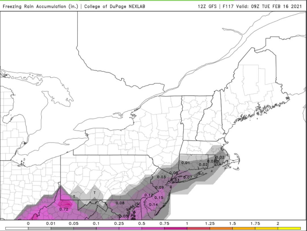
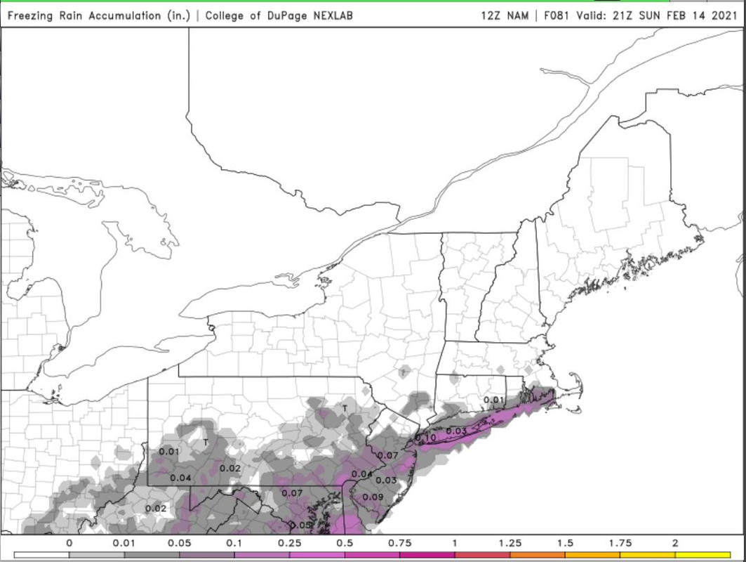
It does not look like a major winter storm is going to impact us on Sunday, however, there may be just enough snow and/or ice to cause disruption beginning late Saturday into Sunday.
GFS freezing rain valid Sunday afternoon
NAM freezing rain valid Sunday afternoon
That said, some models like the ICON show mostly a plain rain and not much in the way of wintry precip. I am not going to issue a forecast for this storm unless there are drastic changes over the next 24 hours. For now, expect wintry precip - maybe starting as snow - to begin Saturday afternoon and gradually changeover to sleet/freezing rain and then a plain rain (especially shore/LI).
I will be lowing the SCI for Sunday. We'll continue tracking the potential bigger winter storm looming for Tuesday in the long range thread.
GFS freezing rain valid Sunday afternoon

NAM freezing rain valid Sunday afternoon

That said, some models like the ICON show mostly a plain rain and not much in the way of wintry precip. I am not going to issue a forecast for this storm unless there are drastic changes over the next 24 hours. For now, expect wintry precip - maybe starting as snow - to begin Saturday afternoon and gradually changeover to sleet/freezing rain and then a plain rain (especially shore/LI).
I will be lowing the SCI for Sunday. We'll continue tracking the potential bigger winter storm looming for Tuesday in the long range thread.
Last edited by Frank_Wx on Fri Feb 12, 2021 9:22 am; edited 2 times in total
_________________
_______________________________________________________________________________________________________
CLICK HERE to view NJ Strong Snowstorm Classifications
weatherwatchermom likes this post
 Re: FEB 13th-16th Snow, Ice and Rain
EURO for Sunday - ticked colder
.10 - .25 of ice in NNJ, LHV and LI I would say is in store


.10 - .25 of ice in NNJ, LHV and LI I would say is in store


_________________
Mugs
AKA:King: Snow Weenie
Self Proclaimed
WINTER 2014-15 : 55.12" +.02 for 6 coatings (avg. 35")
WINTER 2015-16 Total - 29.8" (Avg 35")
WINTER 2016-17 : 39.5" so far

amugs- Advanced Forecaster - Mod

- Posts : 15095
Reputation : 213
Join date : 2013-01-07
Age : 54
Location : Hillsdale,NJ
 Re: FEB 13th-16th Snow, Ice and Rain
Your temps


_________________
Mugs
AKA:King: Snow Weenie
Self Proclaimed
WINTER 2014-15 : 55.12" +.02 for 6 coatings (avg. 35")
WINTER 2015-16 Total - 29.8" (Avg 35")
WINTER 2016-17 : 39.5" so far

amugs- Advanced Forecaster - Mod

- Posts : 15095
Reputation : 213
Join date : 2013-01-07
Age : 54
Location : Hillsdale,NJ
 Re: FEB 13th-16th Snow, Ice and Rain
Yikes...this one is going to be a headache to predict.
_________________
_______________________________________________________________________________________________________
CLICK HERE to view NJ Strong Snowstorm Classifications
 Re: FEB 13th-16th Snow, Ice and Rain
Can you alaborate? In what way? Thought you said above might be some minor ice or sleet and then rain. That seems like no big deal.Frank_Wx wrote:Yikes...this one is going to be a headache to predict.

jmanley32- Senior Enthusiast

- Posts : 20535
Reputation : 108
Join date : 2013-12-12
Age : 43
Location : Yonkers, NY
 Re: FEB 13th-16th Snow, Ice and Rain
ice map?amugs wrote:EURO for Sunday - ticked colder
.10 - .25 of ice in NNJ, LHV and LI I would say is in store

jmanley32- Senior Enthusiast

- Posts : 20535
Reputation : 108
Join date : 2013-12-12
Age : 43
Location : Yonkers, NY
 Re: FEB 13th-16th Snow, Ice and Rain
Not yet - not going tehre but just be prepared for a long ice event in NNJ and LHV - you want the HP to hang in longer to keep us mostly snow if not we have trouble!

_________________
Mugs
AKA:King: Snow Weenie
Self Proclaimed
WINTER 2014-15 : 55.12" +.02 for 6 coatings (avg. 35")
WINTER 2015-16 Total - 29.8" (Avg 35")
WINTER 2016-17 : 39.5" so far

amugs- Advanced Forecaster - Mod

- Posts : 15095
Reputation : 213
Join date : 2013-01-07
Age : 54
Location : Hillsdale,NJ
billg315 likes this post
 Re: FEB 13th-16th Snow, Ice and Rain
A VA FUNGUL !!!
RGEM you can go back home!!
Every model coming in wetter so far!
.gif.5cb44a3ae3e1ec4d27f789e451a2a324.gif)

RGEM


NAM

RGEM you can go back home!!
Every model coming in wetter so far!
.gif.5cb44a3ae3e1ec4d27f789e451a2a324.gif)

RGEM


NAM

_________________
Mugs
AKA:King: Snow Weenie
Self Proclaimed
WINTER 2014-15 : 55.12" +.02 for 6 coatings (avg. 35")
WINTER 2015-16 Total - 29.8" (Avg 35")
WINTER 2016-17 : 39.5" so far

amugs- Advanced Forecaster - Mod

- Posts : 15095
Reputation : 213
Join date : 2013-01-07
Age : 54
Location : Hillsdale,NJ
Frank_Wx likes this post

jmanley32- Senior Enthusiast

- Posts : 20535
Reputation : 108
Join date : 2013-12-12
Age : 43
Location : Yonkers, NY
 Re: FEB 13th-16th Snow, Ice and Rain
That's bad.
Like check the generator bad.
Like check the generator bad.

essexcountypete- Pro Enthusiast

- Posts : 783
Reputation : 12
Join date : 2013-12-09
Location : Bloomfield, NJ
 Re: FEB 13th-16th Snow, Ice and Rain
yeah and we could be talking a second even worse ice storm 2 days later. Does this one have a chance at being snow? At least with 16th we have plenty time. With this one not so much.essexcountypete wrote:That's bad.
Like check the generator bad.

jmanley32- Senior Enthusiast

- Posts : 20535
Reputation : 108
Join date : 2013-12-12
Age : 43
Location : Yonkers, NY
 Re: FEB 13th-16th Snow, Ice and Rain
Worst case scenario is not a good one: We get shut down by ice Sunday, with power outages caused by ice accumulation on power lines and trees. And before they can deal with those power outages we get a crippling ice storm Monday night into Tuesday with more power outages. We'd be trapped in our houses for 3 or 4 days some of us with no power and below freezing temps. Soooo, let's hope that doesn't happen.

billg315- Advanced Forecaster - Mod

- Posts : 4483
Reputation : 185
Join date : 2015-01-24
Age : 50
Location : Flemington, NJ
 Re: FEB 13th-16th Snow, Ice and Rain
I have a bad feeling that the potential situation isn't go be far from th wcs. Let's hope for snow or I guess sleet. But the somewhat consistent frz threat is def somewhat alarming especially if it's 2.billg315 wrote:Worst case scenario is not a good one: We get shut down by ice Sunday, with power outages caused by ice accumulation on power lines and trees. And before they can deal with those power outages we get a crippling ice storm Monday night into Tuesday with more power outages. We'd be trapped in our houses for 3 or 4 days some of us with no power and below freezing temps. Soooo, let's hope that doesn't happen.

jmanley32- Senior Enthusiast

- Posts : 20535
Reputation : 108
Join date : 2013-12-12
Age : 43
Location : Yonkers, NY
 Re: FEB 13th-16th Snow, Ice and Rain
Weekend update:
Light bands of snow and sleet will spread across NJ beginning 11am Saturday. Any snow will changeover to sleet fast, and maybe even mix with plain rain along the shore. Some places will see freezing rain mixing in as well, and that's the difficult part of this forecast. Who and where exactly gets the freezing rain is not clear on the models. It also seems as if this wintry precipitation is going to last into most of Sunday too. It's not going to be a consistently precipitating - it will be fairly spotty and isolated.
There will be a bit of a lull before heavier precipitation moves in Monday morning and essentially last through all day Tuesday. This is where the 'real' concern is because models show significant icing developing as part of the Tuesday wave.
We'll continue watching and proving updates as they come in.
_________________
_______________________________________________________________________________________________________
CLICK HERE to view NJ Strong Snowstorm Classifications
 Re: FEB 13th-16th Snow, Ice and Rain
frank Gm will this be a crazy ice storm for the Bronx or a sleet stormFrank_Wx wrote:Weekend update:
Light bands of snow and sleet will spread across NJ beginning 11am Saturday. Any snow will changeover to sleet fast, and maybe even mix with plain rain along the shore. Some places will see freezing rain mixing in as well, and that's the difficult part of this forecast. Who and where exactly gets the freezing rain is not clear on the models. It also seems as if this wintry precipitation is going to last into most of Sunday too. It's not going to be a consistently precipitating - it will be fairly spotty and isolated.
There will be a bit of a lull before heavier precipitation moves in Monday morning and essentially last through all day Tuesday. This is where the 'real' concern is because models show significant icing developing as part of the Tuesday wave.
We'll continue watching and proving updates as they come in.
frank 638- Senior Enthusiast

- Posts : 2843
Reputation : 37
Join date : 2016-01-01
Age : 40
Location : bronx ny
 Re: FEB 13th-16th Snow, Ice and Rain
frank 638 wrote:frank Gm will this be a crazy ice storm for the Bronx or a sleet stormFrank_Wx wrote:Weekend update:
Light bands of snow and sleet will spread across NJ beginning 11am Saturday. Any snow will changeover to sleet fast, and maybe even mix with plain rain along the shore. Some places will see freezing rain mixing in as well, and that's the difficult part of this forecast. Who and where exactly gets the freezing rain is not clear on the models. It also seems as if this wintry precipitation is going to last into most of Sunday too. It's not going to be a consistently precipitating - it will be fairly spotty and isolated.
There will be a bit of a lull before heavier precipitation moves in Monday morning and essentially last through all day Tuesday. This is where the 'real' concern is because models show significant icing developing as part of the Tuesday wave.
We'll continue watching and proving updates as they come in.
Hard to tell. It's pretty rare that NYC gets big ice accretion. Does anyone know when the last big ice storm was for NYC and surrounding boroughs?
_________________
_______________________________________________________________________________________________________
CLICK HERE to view NJ Strong Snowstorm Classifications
 Re: FEB 13th-16th Snow, Ice and Rain
Frank last time that happened was in 1994 we had bad Ice storm and I think In 95
frank 638- Senior Enthusiast

- Posts : 2843
Reputation : 37
Join date : 2016-01-01
Age : 40
Location : bronx ny
 Re: FEB 13th-16th Snow, Ice and Rain
what do you consider big we got like .25 just 2 yrs ago had trees down though nothing like 1994. So there's no shot our area sees snow from this? And Frank the Bronx doesn't have same climate as Manhattan I live on the border and I can tell you the Bronx often sees the same as here unless you get way south Bronx.Frank_Wx wrote:frank 638 wrote:frank Gm will this be a crazy ice storm for the Bronx or a sleet stormFrank_Wx wrote:Weekend update:
Light bands of snow and sleet will spread across NJ beginning 11am Saturday. Any snow will changeover to sleet fast, and maybe even mix with plain rain along the shore. Some places will see freezing rain mixing in as well, and that's the difficult part of this forecast. Who and where exactly gets the freezing rain is not clear on the models. It also seems as if this wintry precipitation is going to last into most of Sunday too. It's not going to be a consistently precipitating - it will be fairly spotty and isolated.
There will be a bit of a lull before heavier precipitation moves in Monday morning and essentially last through all day Tuesday. This is where the 'real' concern is because models show significant icing developing as part of the Tuesday wave.
We'll continue watching and proving updates as they come in.
Hard to tell. It's pretty rare that NYC gets big ice accretion. Does anyone know when the last big ice storm was for NYC and surrounding boroughs?

jmanley32- Senior Enthusiast

- Posts : 20535
Reputation : 108
Join date : 2013-12-12
Age : 43
Location : Yonkers, NY
 Re: FEB 13th-16th Snow, Ice and Rain
jmanley32 wrote:what do you consider big we got like .25 just 2 yrs ago had trees down though nothing like 1994. So there's no shot our area sees snow from this? And Frank the Bronx doesn't have same climate as Manhattan I live on the border and I can tell you the Bronx often sees the same as here unless you get way south Bronx.Frank_Wx wrote:frank 638 wrote:frank Gm will this be a crazy ice storm for the Bronx or a sleet stormFrank_Wx wrote:Weekend update:
Light bands of snow and sleet will spread across NJ beginning 11am Saturday. Any snow will changeover to sleet fast, and maybe even mix with plain rain along the shore. Some places will see freezing rain mixing in as well, and that's the difficult part of this forecast. Who and where exactly gets the freezing rain is not clear on the models. It also seems as if this wintry precipitation is going to last into most of Sunday too. It's not going to be a consistently precipitating - it will be fairly spotty and isolated.
There will be a bit of a lull before heavier precipitation moves in Monday morning and essentially last through all day Tuesday. This is where the 'real' concern is because models show significant icing developing as part of the Tuesday wave.
We'll continue watching and proving updates as they come in.
Hard to tell. It's pretty rare that NYC gets big ice accretion. Does anyone know when the last big ice storm was for NYC and surrounding boroughs?
94 yes was insane as arctic front caught up the storm and turned us into a frozen tundra for days on end.
VDay 07? sleet fest up here but in teh city I do not know temps was 24* up here and just poured sleet for hours.
_________________
Mugs
AKA:King: Snow Weenie
Self Proclaimed
WINTER 2014-15 : 55.12" +.02 for 6 coatings (avg. 35")
WINTER 2015-16 Total - 29.8" (Avg 35")
WINTER 2016-17 : 39.5" so far

amugs- Advanced Forecaster - Mod

- Posts : 15095
Reputation : 213
Join date : 2013-01-07
Age : 54
Location : Hillsdale,NJ
 Re: FEB 13th-16th Snow, Ice and Rain
For Long Island after the the possible ice will the temps rise and rain most likely fall and melt the ice away?
Scullybutcher- Pro Enthusiast

- Posts : 543
Reputation : 16
Join date : 2013-02-06
Location : North Smithtown, western Suffolk county, long island
 Re: FEB 13th-16th Snow, Ice and Rain
amugs wrote:jmanley32 wrote:what do you consider big we got like .25 just 2 yrs ago had trees down though nothing like 1994. So there's no shot our area sees snow from this? And Frank the Bronx doesn't have same climate as Manhattan I live on the border and I can tell you the Bronx often sees the same as here unless you get way south Bronx.Frank_Wx wrote:frank 638 wrote:frank Gm will this be a crazy ice storm for the Bronx or a sleet stormFrank_Wx wrote:Weekend update:
Light bands of snow and sleet will spread across NJ beginning 11am Saturday. Any snow will changeover to sleet fast, and maybe even mix with plain rain along the shore. Some places will see freezing rain mixing in as well, and that's the difficult part of this forecast. Who and where exactly gets the freezing rain is not clear on the models. It also seems as if this wintry precipitation is going to last into most of Sunday too. It's not going to be a consistently precipitating - it will be fairly spotty and isolated.
There will be a bit of a lull before heavier precipitation moves in Monday morning and essentially last through all day Tuesday. This is where the 'real' concern is because models show significant icing developing as part of the Tuesday wave.
We'll continue watching and proving updates as they come in.
Hard to tell. It's pretty rare that NYC gets big ice accretion. Does anyone know when the last big ice storm was for NYC and surrounding boroughs?
94 yes was insane as arctic front caught up the storm and turned us into a frozen tundra for days on end.
VDay 07? sleet fest up here but in teh city I do not know temps was 24* up here and just poured sleet for hours.
I’ll never forget the 1994 ice storm. I was living in Jamaica Queens. I have never seen anything like it in terms of ice accumulation. I remember the forecast was for plain rain but temps dropped into the 20’s and never went above freezing. Forecast changed quickly to Ice Storm Warning. There was no melting for days. In fact if you didn’t chip away at it, it would still be there weeks later with snowfall on top of it. Many slip and falls, some even lost their lives. My mom and dad fell a couple of times, even many days after the storm.
CnWestMilford76- Posts : 30
Reputation : 0
Join date : 2020-12-15
 Re: FEB 13th-16th Snow, Ice and Rain
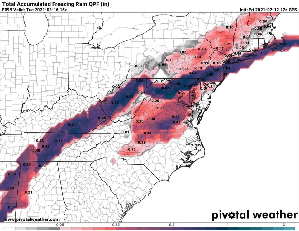
The 12Z GFS shows just how precarious this is right now. The baroclinic zone sets up shop just a little (150 miles) to our NW. The mid level storms are a bit too far north too since the zone sets up too far north. Taken verbatim the threat is ice from this and not too much snow unless you're well north of I-84 or I-81 above Scranton.
I think the threat for severe icing is NW of I-95 is real because I believe mid-levels (4000-5000 feet ASL) are going to torch, but low level coldness will hold strong NW of I-95.
I've seen this movie before and it usually has a bad ending.
I think the threat for severe icing is NW of I-95 is real because I believe mid-levels (4000-5000 feet ASL) are going to torch, but low level coldness will hold strong NW of I-95.
I've seen this movie before and it usually has a bad ending.
heehaw453- Advanced Forecaster

- Posts : 3906
Reputation : 86
Join date : 2014-01-20
Location : Bedminster Township, PA Elevation 600' ASL

aiannone- Senior Enthusiast - Mod

- Posts : 4815
Reputation : 92
Join date : 2013-01-07
Location : Saint James, LI (Northwest Suffolk Co.)
 Re: FEB 13th-16th Snow, Ice and Rain
heehaw453 wrote:The 12Z GFS shows just how precarious this is right now. The baroclinic zone sets up shop just a little (150 miles) to our NW. The mid level storms are a bit too far north too since the zone sets up too far north. Taken verbatim the threat is ice from this and not too much snow unless you're well north of I-84 or I-81 above Scranton.
I think the threat for severe icing is NW of I-95 is real because I believe mid-levels (4000-5000 feet ASL) are going to torch, but low level coldness will hold strong NW of I-95.
I've seen this movie before and it usually has a bad ending.
I know it's a little too far out to be looking at right now, but it looks like this movie might have a sequel a few days later. How can what happens this storm impact what happens next storm, if at all?
TheAresian- Senior Enthusiast

- Posts : 145
Reputation : 10
Join date : 2019-11-13
Location : Painted Post, NY
 Re: FEB 13th-16th Snow, Ice and Rain
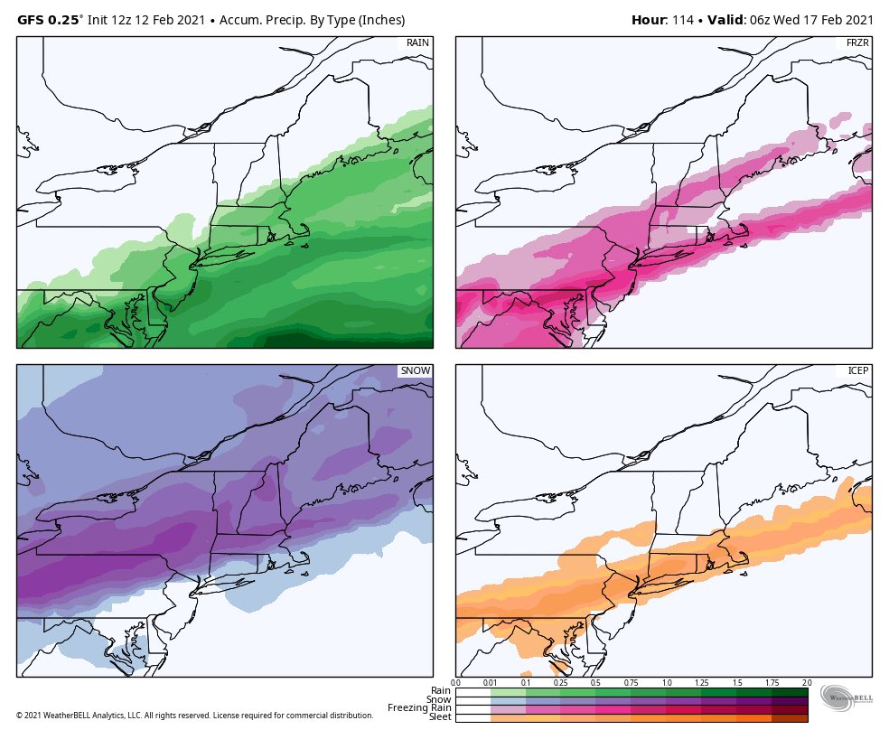
Both storms 12 Z GFS - amazing we went from a full blown snowstorm to a slop fest - MJO wave 7 at play here and moderate Nina in Feb(?)
As Walt Drag has said he believes the snow axis is the I 84 and North Corridor. /interior. I personally do not like this trend - we were to have a piece of PV just west of us in the Lake Michigan area to Erie that would have pushed the cold deep into the MA, we have it stuck in the Plains and it tries to bleed east with very cold air over the top. We have as Scott pointed out a MJO wave in Phase 7 which in a NINA is warm but the -AO/NAO couplet has fought that off for weeks now. It’s been a moderate Nina, we have the AO and NAO retreating and allowing more SE Ridge. We have lost basically 3 storms this week that WERE showing SECS plus snowstorms, did we snow yes but not nearly to the advertisement of the models (plural).
GFS a show snizzle and even rain on Sunday into Monday now and then after the storm departs we go into single digits that night = rapid freeze?
Time will tell but the trends are not there for a snowstorm but rather an ice storm at this time
_________________
Mugs
AKA:King: Snow Weenie
Self Proclaimed
WINTER 2014-15 : 55.12" +.02 for 6 coatings (avg. 35")
WINTER 2015-16 Total - 29.8" (Avg 35")
WINTER 2016-17 : 39.5" so far

amugs- Advanced Forecaster - Mod

- Posts : 15095
Reputation : 213
Join date : 2013-01-07
Age : 54
Location : Hillsdale,NJ
Page 1 of 10 • 1, 2, 3, 4, 5, 6, 7, 8, 9, 10 
Page 1 of 10
Permissions in this forum:
You cannot reply to topics in this forum|
|
|

 Home
Home
