
 Search
FEB 13th-16th Snow, Ice and Rain
Page 6 of 10 •  1, 2, 3, 4, 5, 6, 7, 8, 9, 10
 ![]()
Re: FEB 13th-16th Snow, Ice and Rain
![]() by heehaw453 Sun Feb 14, 2021 10:20 am
by heehaw453 Sun Feb 14, 2021 10:20 am
Frank_Wx wrote:HRRR ice accumulation
NWS might be too aggressive for parts of NNJ but conservative N&W
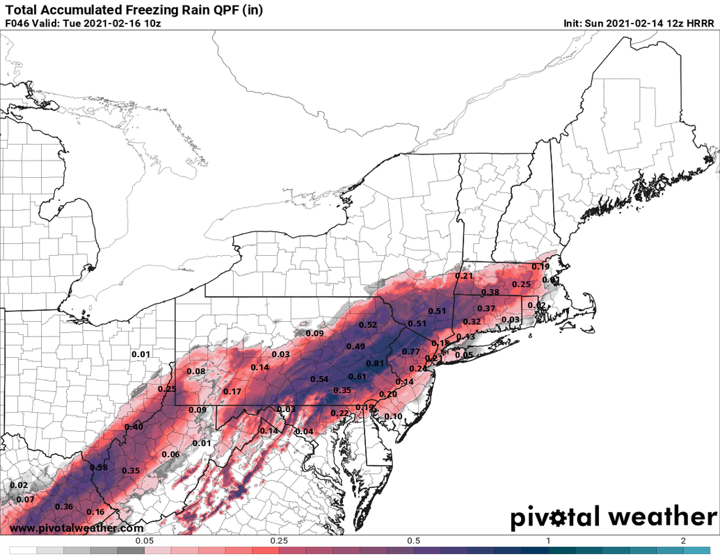
I agree with you. I think the highest risk is west of the Fall Line especially in areas of > 500' ASL. I'm fully expecting between .25" - .5" IMBY towards the Lehigh Valley. NEPA should expect > .5" as should NW NJ, and LHV IMO. The ground has been cold for a really long time and that must be considered in this setup.
heehaw453- Advanced Forecaster

- Posts : 3906
Join date : 2014-01-20
Re: FEB 13th-16th Snow, Ice and Rain
![]() by Zhukov1945 Sun Feb 14, 2021 10:38 am
by Zhukov1945 Sun Feb 14, 2021 10:38 am
Zhukov1945- Posts : 138
Join date : 2018-03-21
Re: FEB 13th-16th Snow, Ice and Rain
![]() by heehaw453 Sun Feb 14, 2021 10:42 am
by heehaw453 Sun Feb 14, 2021 10:42 am
Zhukov1945 wrote:Possibly ignorant / basic question but what is the "Fall Line"?
It separates coastal flat land versus more elevated areas. It pretty much runs the I-95 and often times surface temperatures are much more influenced (raised) by easterly fetch off Atlantic in areas east of the fall line versus west.
heehaw453- Advanced Forecaster
- Posts : 3906
Reputation : 86
Join date : 2014-01-20
Location : Bedminster Township, PA Elevation 600' ASL
Zhukov1945 likes this post
Re: FEB 13th-16th Snow, Ice and Rain
![]() by jmanley32 Sun Feb 14, 2021 11:21 am
by jmanley32 Sun Feb 14, 2021 11:21 am
Last edited by jmanley32 on Sun Feb 14, 2021 12:24 pm; edited 1 time in total

jmanley32- Senior Enthusiast

- Posts : 20535
Reputation : 108
Join date : 2013-12-12
Age : 43
Location : Yonkers, NY
Re: FEB 13th-16th Snow, Ice and Rain
![]() by jmanley32 Sun Feb 14, 2021 11:46 am
by jmanley32 Sun Feb 14, 2021 11:46 am
1st call NWS

jmanley32- Senior Enthusiast
- Posts : 20535
Reputation : 108
Join date : 2013-12-12
Age : 43
Location : Yonkers, NY
Re: FEB 13th-16th Snow, Ice and Rain
![]() by jmanley32 Sun Feb 14, 2021 12:12 pm
by jmanley32 Sun Feb 14, 2021 12:12 pm
Frank since when does the HRRR go out so far? I only see out to hour 18 on pivotal weather. Looks like thats hour 46.heehaw453 wrote:Frank_Wx wrote:HRRR ice accumulation
NWS might be too aggressive for parts of NNJ but conservative N&W
I agree with you. I think the highest risk is west of the Fall Line especially in areas of > 500' ASL. I'm fully expecting between .25" - .5" IMBY towards the Lehigh Valley. NEPA should expect > .5" as should NW NJ, and LHV IMO. The ground has been cold for a really long time and that must be considered in this setup.
jmanley32- Senior Enthusiast
- Posts : 20535
Reputation : 108
Join date : 2013-12-12
Age : 43
Location : Yonkers, NY
Re: FEB 13th-16th Snow, Ice and Rain
![]() by amugs Sun Feb 14, 2021 12:59 pm
by amugs Sun Feb 14, 2021 12:59 pm
It can be an 8-12 hour icing event N&W of NYC. Any subtle movements of the HP, LP can have major consequences at the surface. This model has been very good with our storms this winter. Tjis is Freezing Rain = yikes

_________________
Mugs
AKA:King: Snow Weenie
Self Proclaimed
WINTER 2014-15 : 55.12" +.02 for 6 coatings (avg. 35")
WINTER 2015-16 Total - 29.8" (Avg 35")
WINTER 2016-17 : 39.5" so far

amugs- Advanced Forecaster - Mod

- Posts : 15095
Reputation : 213
Join date : 2013-01-07
Age : 54
Location : Hillsdale,NJ
Re: FEB 13th-16th Snow, Ice and Rain
![]() by jmanley32 Sun Feb 14, 2021 1:21 pm
by jmanley32 Sun Feb 14, 2021 1:21 pm
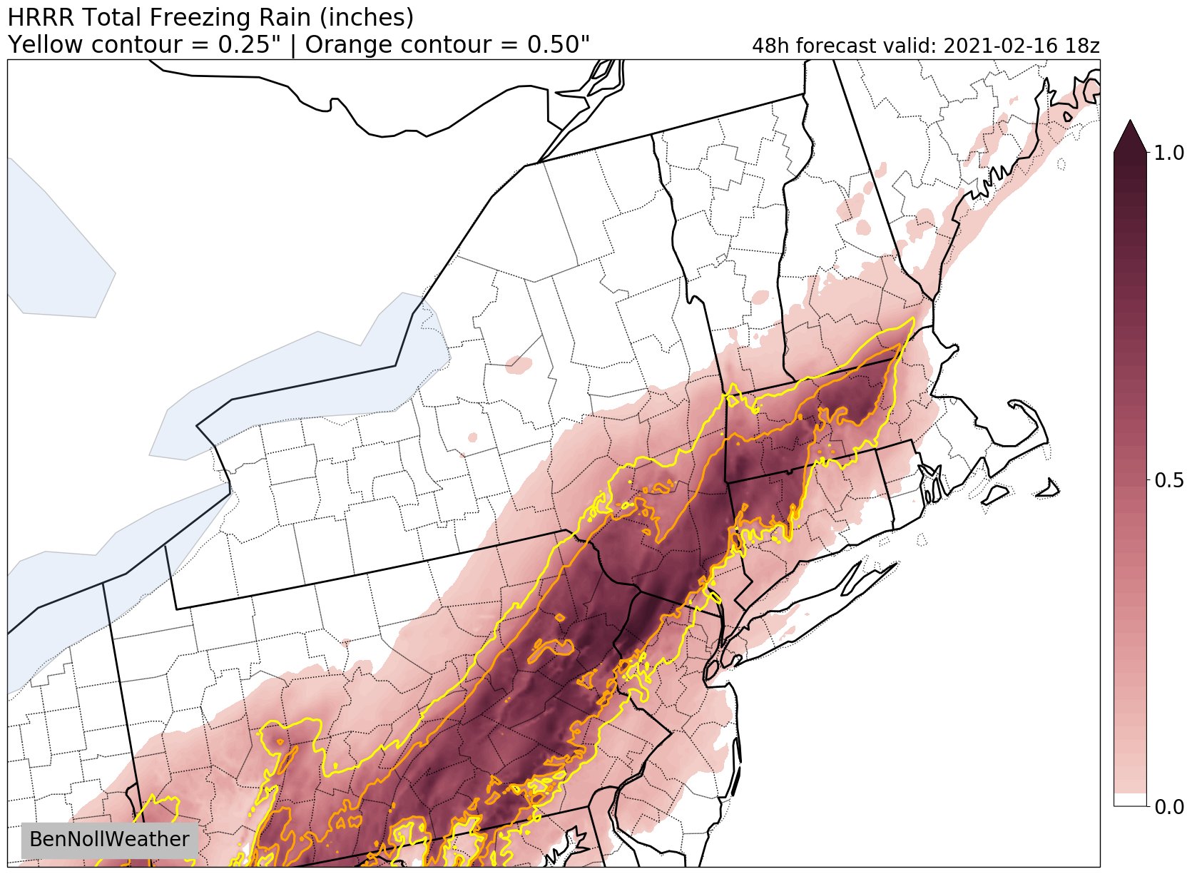
wow this is more agressive right down to the coast with 0.25-.50 thats trouble the blue area even worse, that may be underdone for up there as many other models are showing 1.0+ is that even possible mugs? I just cannot imagine that much ice anywhere in the area north or south, even 0.25+ down to southern westchester and near coastal NJ and CT seems pretty unheard of. So with the usual wobble of the system during the event I guess this will be a rather nowcast situation. But where the blue is is probably going to see the most icning but it looks like most of us are in for moderate to severe icing per that map.amugs wrote:HREF is VERY concerning. Got this site for this from Sir Walter Drag.
It can be an 8-12 hour icing event N&W of NYC. Any subtle movements of the HP, LP can have major consequences at the surface. This model has been very good with our storms this winter. Tjis is Freezing Rain = yikes
Edit oh dayumm thats the ensemble mean!! Jesus that means there are likely members that are way more and some way less, is there anyway to see the individual members for that model? I cannot find that model nor have i heard of us using it.
jmanley32- Senior Enthusiast
- Posts : 20535
Reputation : 108
Join date : 2013-12-12
Age : 43
Location : Yonkers, NY
Re: FEB 13th-16th Snow, Ice and Rain
![]() by heehaw453 Sun Feb 14, 2021 3:18 pm
by heehaw453 Sun Feb 14, 2021 3:18 pm
Ice Storm Warning
URGENT - WINTER WEATHER MESSAGE
National Weather Service Mount Holly NJ
315 PM EST Sun Feb 14 2021
NJZ009-010-PAZ060-101-103-105-151100-
/O.NEW.KPHI.IS.W.0001.210215T2300Z-210216T1500Z/
Hunterdon-Somerset-Berks-Western Chester-Western Montgomery-
Upper Bucks-
Including the cities of Flemington, Somerville, Reading,
Honey Brook, Oxford, Collegeville, Pottstown, Chalfont,
and Perkasie
315 PM EST Sun Feb 14 2021
...ICE STORM WARNING IN EFFECT FROM 6 PM MONDAY TO 10 AM EST
TUESDAY...
* WHAT...Significant icing expected. Total ice accumulations of
two tenths to three tenths of an inch with up to one inch of
snow and sleet.
* WHERE...Portions of northern New Jersey and east central and
southeast Pennsylvania.
* WHEN...From 6 PM Monday to 10 AM EST Tuesday.
* IMPACTS...Power outages and tree damage are likely due to the
ice. Travel could be extremely difficult. The hazardous
conditions will impact the morning commute on Tuesday.
PRECAUTIONARY/PREPAREDNESS ACTIONS...
Travel is strongly discouraged. If you must travel, keep an extra
flashlight, food, and water in your vehicle in case of an
emergency. Prepare for possible power outages.
The latest road conditions for the state you are calling from can
be obtained by calling 5 1 1.
heehaw453- Advanced Forecaster
- Posts : 3906
Reputation : 86
Join date : 2014-01-20
Location : Bedminster Township, PA Elevation 600' ASL
Re: FEB 13th-16th Snow, Ice and Rain
![]() by billg315 Sun Feb 14, 2021 3:21 pm
by billg315 Sun Feb 14, 2021 3:21 pm

billg315- Advanced Forecaster - Mod
- Posts : 4483
Reputation : 185
Join date : 2015-01-24
Age : 50
Location : Flemington, NJ
Re: FEB 13th-16th Snow, Ice and Rain
![]() by frank 638 Sun Feb 14, 2021 3:21 pm
by frank 638 Sun Feb 14, 2021 3:21 pm
frank 638- Senior Enthusiast
- Posts : 2843
Reputation : 37
Join date : 2016-01-01
Age : 40
Location : bronx ny
Re: FEB 13th-16th Snow, Ice and Rain
![]() by billg315 Sun Feb 14, 2021 3:22 pm
by billg315 Sun Feb 14, 2021 3:22 pm
billg315- Advanced Forecaster - Mod
- Posts : 4483
Reputation : 185
Join date : 2015-01-24
Age : 50
Location : Flemington, NJ
Zhukov1945 likes this post
Re: FEB 13th-16th Snow, Ice and Rain
![]() by billg315 Sun Feb 14, 2021 3:24 pm
by billg315 Sun Feb 14, 2021 3:24 pm
billg315- Advanced Forecaster - Mod
- Posts : 4483
Reputation : 185
Join date : 2015-01-24
Age : 50
Location : Flemington, NJ
Re: FEB 13th-16th Snow, Ice and Rain
![]() by jmanley32 Sun Feb 14, 2021 3:28 pm
by jmanley32 Sun Feb 14, 2021 3:28 pm
imo we may see a ice storm warning in Westchester. I dunno what our criteria is but it's lower than inland prolly. And heehaw I think those amounts are pretty conservative no?frank 638 wrote:I wonder if we will get a winter weather Advisory for nyc
jmanley32- Senior Enthusiast
- Posts : 20535
Reputation : 108
Join date : 2013-12-12
Age : 43
Location : Yonkers, NY
Re: FEB 13th-16th Snow, Ice and Rain
![]() by heehaw453 Sun Feb 14, 2021 3:32 pm
by heehaw453 Sun Feb 14, 2021 3:32 pm
jmanley32 wrote:imo we may see a ice storm warning in Westchester. I dunno what our criteria is but it's lower than inland prolly. And heehaw I think those amounts are pretty conservative no?frank 638 wrote:I wonder if we will get a winter weather Advisory for nyc
I think they're good for now based on what I see from models. The most sig impacts will be NW NJ, NEPA and LHV by far. They will probably get >= .6" of ice. Let's just hope for more low level warmth, but I'm skeptical due to the state of the surface snowpack.
heehaw453- Advanced Forecaster
- Posts : 3906
Reputation : 86
Join date : 2014-01-20
Location : Bedminster Township, PA Elevation 600' ASL
Re: FEB 13th-16th Snow, Ice and Rain
![]() by jmanley32 Sun Feb 14, 2021 3:32 pm
by jmanley32 Sun Feb 14, 2021 3:32 pm
yeah I think most up hete never seen that. Scary one says up to .5!! It'll be worse if the snow comes 1st. If it comes after it'll actually be better. But by in far super bad situation. We will have to see where this sets up. Of course Upton doesn't even have a hwo. Yet they show my area getting.1 to.2 as of right now. NYC .09 which I find hard to believe but in this setup posdible.billg315 wrote:I think this is the first Ice Storm Warning I’ve ever been under.
jmanley32- Senior Enthusiast
- Posts : 20535
Reputation : 108
Join date : 2013-12-12
Age : 43
Location : Yonkers, NY
Re: FEB 13th-16th Snow, Ice and Rain
![]() by jmanley32 Sun Feb 14, 2021 3:33 pm
by jmanley32 Sun Feb 14, 2021 3:33 pm
so I'm technically part of lhv u don't think we see any Sig icing? Doesn't need be .5 plus to be a big issue.heehaw453 wrote:jmanley32 wrote:imo we may see a ice storm warning in Westchester. I dunno what our criteria is but it's lower than inland prolly. And heehaw I think those amounts are pretty conservative no?frank 638 wrote:I wonder if we will get a winter weather Advisory for nyc
I think they're good for now based on what I see from models. The most sig impacts will be NW NJ, NEPA and LHV by far. They will probably get >= .6" of ice. Let's just hope for more low level warmth, but I'm skeptical due to the state of the surface snowpack.
jmanley32- Senior Enthusiast
- Posts : 20535
Reputation : 108
Join date : 2013-12-12
Age : 43
Location : Yonkers, NY
Re: FEB 13th-16th Snow, Ice and Rain
![]() by heehaw453 Sun Feb 14, 2021 3:35 pm
by heehaw453 Sun Feb 14, 2021 3:35 pm
jmanley32 wrote:so I'm technically part of lhv u don't think we see any Sig icing? Doesn't need be .5 plus to be a big issue.heehaw453 wrote:jmanley32 wrote:imo we may see a ice storm warning in Westchester. I dunno what our criteria is but it's lower than inland prolly. And heehaw I think those amounts are pretty conservative no?frank 638 wrote:I wonder if we will get a winter weather Advisory for nyc
I think they're good for now based on what I see from models. The most sig impacts will be NW NJ, NEPA and LHV by far. They will probably get >= .6" of ice. Let's just hope for more low level warmth, but I'm skeptical due to the state of the surface snowpack.
Elevated areas like Orange County would be my concern. I think lower elevated areas of the LHV will be much less impacted by ice.
heehaw453- Advanced Forecaster
- Posts : 3906
Reputation : 86
Join date : 2014-01-20
Location : Bedminster Township, PA Elevation 600' ASL
Re: FEB 13th-16th Snow, Ice and Rain
![]() by frank 638 Sun Feb 14, 2021 3:37 pm
by frank 638 Sun Feb 14, 2021 3:37 pm
ok thank you for the update Just wish this will be a old fashion snowstormjmanley32 wrote:imo we may see a ice storm warning in Westchester. I dunno what our criteria is but it's lower than inland prolly. And heehaw I think those amounts are pretty conservative no?frank 638 wrote:I wonder if we will get a winter weather Advisory for nyc
frank 638- Senior Enthusiast
- Posts : 2843
Reputation : 37
Join date : 2016-01-01
Age : 40
Location : bronx ny
Re: FEB 13th-16th Snow, Ice and Rain
![]() by jmanley32 Sun Feb 14, 2021 3:37 pm
by jmanley32 Sun Feb 14, 2021 3:37 pm
jmanley32- Senior Enthusiast
- Posts : 20535
Reputation : 108
Join date : 2013-12-12
Age : 43
Location : Yonkers, NY
Re: FEB 13th-16th Snow, Ice and Rain
![]() by amugs Sun Feb 14, 2021 3:37 pm
by amugs Sun Feb 14, 2021 3:37 pm
_________________
Mugs
AKA:King: Snow Weenie
Self Proclaimed
WINTER 2014-15 : 55.12" +.02 for 6 coatings (avg. 35")
WINTER 2015-16 Total - 29.8" (Avg 35")
WINTER 2016-17 : 39.5" so far
amugs- Advanced Forecaster - Mod
- Posts : 15095
Reputation : 213
Join date : 2013-01-07
Age : 54
Location : Hillsdale,NJ
Re: FEB 13th-16th Snow, Ice and Rain
![]() by jmanley32 Sun Feb 14, 2021 3:39 pm
by jmanley32 Sun Feb 14, 2021 3:39 pm
oh completely agree but I could still see a quarter inch fall here b4 rain. Just my 2 cents. They are screwed up there. Hoping for you guys as .6 will cause a ton outages.heehaw453 wrote:jmanley32 wrote:so I'm technically part of lhv u don't think we see any Sig icing? Doesn't need be .5 plus to be a big issue.heehaw453 wrote:jmanley32 wrote:imo we may see a ice storm warning in Westchester. I dunno what our criteria is but it's lower than inland prolly. And heehaw I think those amounts are pretty conservative no?frank 638 wrote:I wonder if we will get a winter weather Advisory for nyc
I think they're good for now based on what I see from models. The most sig impacts will be NW NJ, NEPA and LHV by far. They will probably get >= .6" of ice. Let's just hope for more low level warmth, but I'm skeptical due to the state of the surface snowpack.
Elevated areas like Orange County would be my concern. I think lower elevated areas of the LHV will be much less impacted by ice.
jmanley32- Senior Enthusiast
- Posts : 20535
Reputation : 108
Join date : 2013-12-12
Age : 43
Location : Yonkers, NY
Re: FEB 13th-16th Snow, Ice and Rain
![]() by jmanley32 Sun Feb 14, 2021 3:40 pm
by jmanley32 Sun Feb 14, 2021 3:40 pm
well if tgats true we don't got much to worry bout down here except slick roads and sidewalks. But wow up north.amugs wrote:
jmanley32- Senior Enthusiast
- Posts : 20535
Reputation : 108
Join date : 2013-12-12
Age : 43
Location : Yonkers, NY
Re: FEB 13th-16th Snow, Ice and Rain
![]() by heehaw453 Sun Feb 14, 2021 3:41 pm
by heehaw453 Sun Feb 14, 2021 3:41 pm
jmanley32 wrote:oh completely agree but I could still see a quarter inch fall here b4 rain. Just my 2 cents. They are screwed up there. Hoping for you guys as .6 will cause a ton outages.heehaw453 wrote:jmanley32 wrote:so I'm technically part of lhv u don't think we see any Sig icing? Doesn't need be .5 plus to be a big issue.heehaw453 wrote:jmanley32 wrote:imo we may see a ice storm warning in Westchester. I dunno what our criteria is but it's lower than inland prolly. And heehaw I think those amounts are pretty conservative no?frank 638 wrote:I wonder if we will get a winter weather Advisory for nyc
I think they're good for now based on what I see from models. The most sig impacts will be NW NJ, NEPA and LHV by far. They will probably get >= .6" of ice. Let's just hope for more low level warmth, but I'm skeptical due to the state of the surface snowpack.
Elevated areas like Orange County would be my concern. I think lower elevated areas of the LHV will be much less impacted by ice.
Good chance your area should get .25" of ice. But as you know doubling that value to .5" is almost exponential in terms of impact. Maybe not exponential, but more than linear that's for sure.
heehaw453- Advanced Forecaster
- Posts : 3906
Reputation : 86
Join date : 2014-01-20
Location : Bedminster Township, PA Elevation 600' ASL
Re: FEB 13th-16th Snow, Ice and Rain
![]() by billg315 Sun Feb 14, 2021 3:46 pm
by billg315 Sun Feb 14, 2021 3:46 pm
amugs wrote:
Wowzers. Not good.
billg315- Advanced Forecaster - Mod
- Posts : 4483
Reputation : 185
Join date : 2015-01-24
Age : 50
Location : Flemington, NJ
Re: FEB 13th-16th Snow, Ice and Rain
![]() by TheAresian Sun Feb 14, 2021 3:51 pm
by TheAresian Sun Feb 14, 2021 3:51 pm
TheAresian- Senior Enthusiast
- Posts : 145
Reputation : 10
Join date : 2019-11-13
Location : Painted Post, NY
Re: FEB 13th-16th Snow, Ice and Rain
![]() by amugs Sun Feb 14, 2021 3:54 pm
by amugs Sun Feb 14, 2021 3:54 pm
Roses are red
— Trent Davis (@TstormTrent) February 14, 2021
Violets are blue
Warnings widespread
One for me, one for you pic.twitter.com/7EDiimgoiG
Not including the latest warning advisories just added in test few hours
_________________
Mugs
AKA:King: Snow Weenie
Self Proclaimed
WINTER 2014-15 : 55.12" +.02 for 6 coatings (avg. 35")
WINTER 2015-16 Total - 29.8" (Avg 35")
WINTER 2016-17 : 39.5" so far
amugs- Advanced Forecaster - Mod
- Posts : 15095
Reputation : 213
Join date : 2013-01-07
Age : 54
Location : Hillsdale,NJ
Page 6 of 10 • 1, 2, 3, 4, 5, 6, 7, 8, 9, 10 ![]()
|
|
|