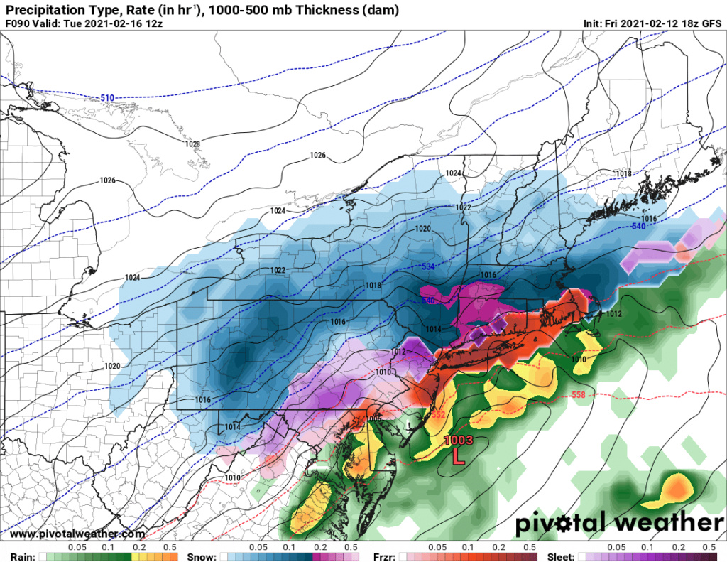
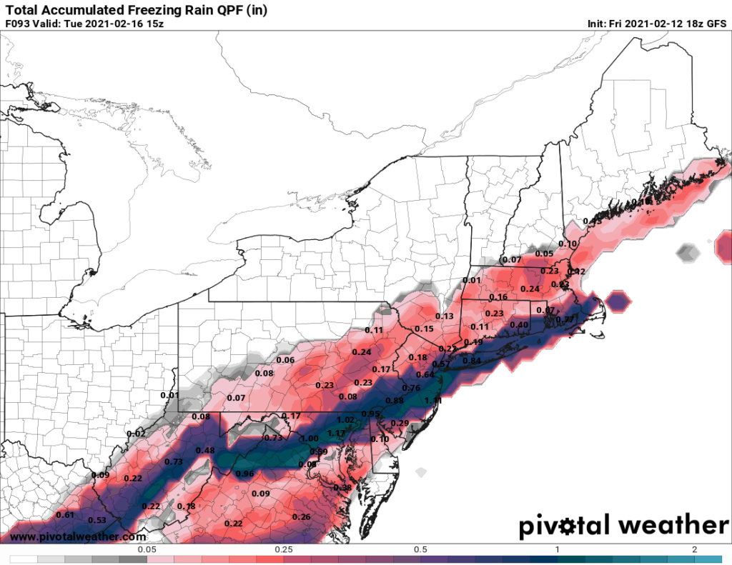
FEB 13th-16th Snow, Ice and Rain
+37
1190ftalt
Sloth269
weatherwatchermom
larryrock72
2004blackwrx
docstox12
Taffy
snowday111
hyde345
toople
Joe Snow
Vinnydula
dkodgis
Zhukov1945
Dunnzoo
Fededle22
Irish
GreyBeard
jimv45
SENJsnowman
lglickman1
elkiehound
phil155
algae888
bobjohnsonforthehall
sroc4
TheAresian
aiannone
heehaw453
CnWestMilford76
Scullybutcher
frank 638
billg315
essexcountypete
jmanley32
amugs
Frank_Wx
41 posters
Page 3 of 10
Page 3 of 10 •  1, 2, 3, 4, 5, 6, 7, 8, 9, 10
 Re: FEB 13th-16th Snow, Ice and Rain
lglickman1 wrote:So is the chance of all snow down to the coast long gone?
No not gone
sroc4- Admin

- Posts : 8354
Join date : 2013-01-07
 Re: FEB 13th-16th Snow, Ice and Rain
Wow VA got quite the ice storm warning, 0.25-0.5 locally more. Its crazy how much of the US has had severe icing past few days.
jmanley32- Senior Enthusiast

- Posts : 20535
Join date : 2013-12-12
 Re: FEB 13th-16th Snow, Ice and Rain
_________________
-Alex Iannone-

aiannone- Senior Enthusiast - Mod

- Posts : 4815
Reputation : 92
Join date : 2013-01-07
Location : Saint James, LI (Northwest Suffolk Co.)
 Re: FEB 13th-16th Snow, Ice and Rain
With the track the GFS had it would have been a lot of snow for the area. The issue is the boundary layer didn't get pulled down far enough from the departing storm so we were left with a bad antecedent air mass. The departing storm meanders and doesn't pull the boundary layer down. It's definitely not an impossibility that snow occurs with this. I think we need to see the other wave move out faster and pull the colder our down.
But you can clearly see how serious this ice threat potential is.
But you can clearly see how serious this ice threat potential is.
heehaw453- Advanced Forecaster

- Posts : 3906
Reputation : 86
Join date : 2014-01-20
Location : Bedminster Township, PA Elevation 600' ASL

jmanley32- Senior Enthusiast

- Posts : 20535
Reputation : 108
Join date : 2013-12-12
Age : 43
Location : Yonkers, NY
 Re: FEB 13th-16th Snow, Ice and Rain
https://www.weather.gov/images/okx/0212_5pm.png
Thats for sat. night/sunday.
mon. night/tuesday they say more across interior.
Thats for sat. night/sunday.
mon. night/tuesday they say more across interior.
GreyBeard- Senior Enthusiast

- Posts : 725
Reputation : 34
Join date : 2014-02-12
Location : eastern nassau county
 Re: FEB 13th-16th Snow, Ice and Rain
Winter Weather Advisory from SAT 1:00 PM EST until SUN 1:00 PM EST
Old Bridge, NJ Weather
Weather Alerts-Old Bridge, NJ
Winter Weather Advisory from SAT 1:00 PM EST until SUN 1:00 PM EST
Action Recommended
Execute a pre-planned activity identified in the instructions
Issued By
Philadelphia - PA, US, National Weather Service
Affected Area
Portions of New Jersey and southeast Pennsylvania
Description
...WINTER WEATHER ADVISORY IN EFFECT FROM 1 PM SATURDAY TO 1 PM EST SUNDAY...
WHAT...Mixed precipitation expected. Total snow accumulations of less than one inch and ice accumulations of up to one tenth of an inch.
WHERE...Portions of New Jersey and southeast Pennsylvania.
WHEN...From 1 PM Saturday to 1 PM EST Sunday.
IMPACTS...Difficult travel conditions are possible due to icy roadways, especially Saturday evening through Sunday morning.
PRECAUTIONARY/PREPAREDNESS ACTIONS...
Slow down and use caution while traveling.
The latest road conditions for the state you are calling from can be obtained by calling 5 1 1.

Irish- Pro Enthusiast

- Posts : 788
Reputation : 19
Join date : 2019-01-16
Age : 45
Location : Old Bridge, NJ
 Re: FEB 13th-16th Snow, Ice and Rain
GFS and NAM show sleet from CNJ, the shore and LI tomorrow around 4-8pm.
The Tuesday storm appears to be trending a bit colder. I still have a gut feeling N&W of NYC gets hit pretty hard with snow. That means there is a sleet/ice threat for those just N&W of NYC and NNJ. Let’s see what transpires tomorrow. Very tricky forecast
The Tuesday storm appears to be trending a bit colder. I still have a gut feeling N&W of NYC gets hit pretty hard with snow. That means there is a sleet/ice threat for those just N&W of NYC and NNJ. Let’s see what transpires tomorrow. Very tricky forecast
_________________
_______________________________________________________________________________________________________
CLICK HERE to view NJ Strong Snowstorm Classifications

jmanley32- Senior Enthusiast

- Posts : 20535
Reputation : 108
Join date : 2013-12-12
Age : 43
Location : Yonkers, NY
 Re: FEB 13th-16th Snow, Ice and Rain
Thoughts on Monday AM icing area if any?

elkiehound- Posts : 56
Reputation : 1
Join date : 2013-12-09
Location : Ringoes NJ
 Re: FEB 13th-16th Snow, Ice and Rain
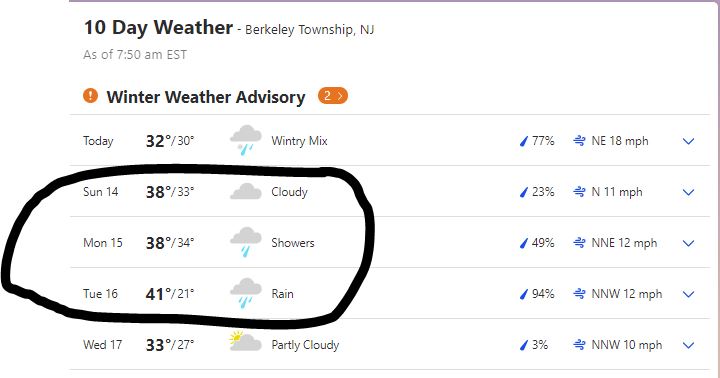
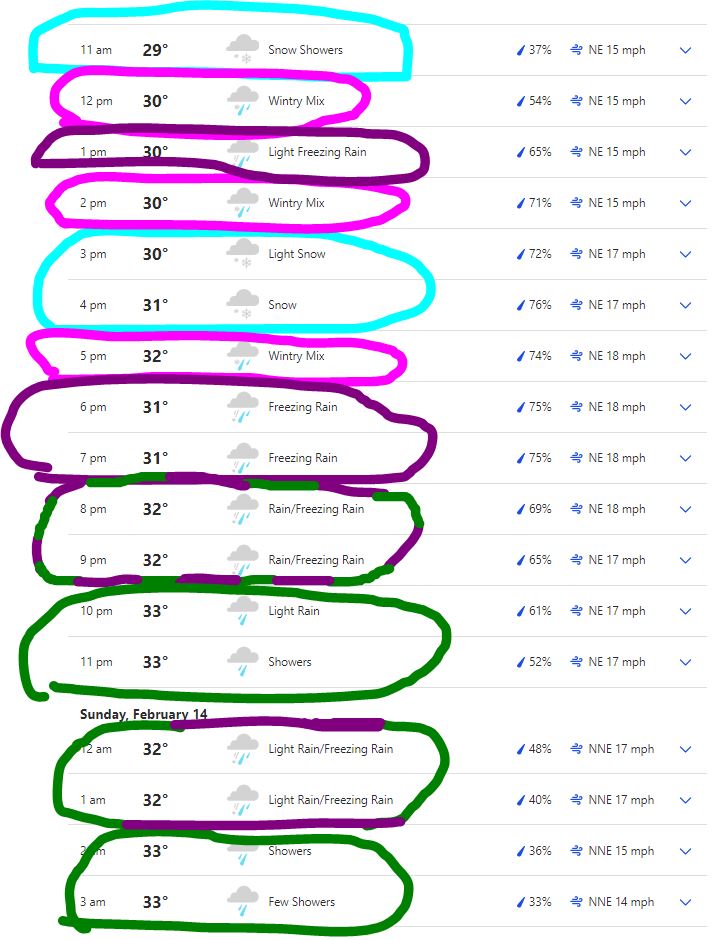
Thankfully, as of now, the Jersey Shore looks to have minimal winter impacts from this storm beyond today. But today could be a bit of a mess. Not quite sure what to make of this hourly forecast. Hoping to get in another few hours of snow fall maybe, before the slop and rain set in? Gonna salt real well today for sure and plan to stay off the roads once that frz starts and just hunker down (had to look that up, hunker or bunker? apparently, there is no such thing as 'bunker down' unless you hit it into the sand trap- lol).


SENJsnowman- Senior Enthusiast

- Posts : 1189
Reputation : 61
Join date : 2017-01-06
Age : 51
Location : Bayville, NJ
 Re: FEB 13th-16th Snow, Ice and Rain
If I'm reading these maps right, I guess this is a pretty understandable recipe for a freezing rain/ice storm (for 3 pm today):
Freezing at higher levels (500mb and 700mb):
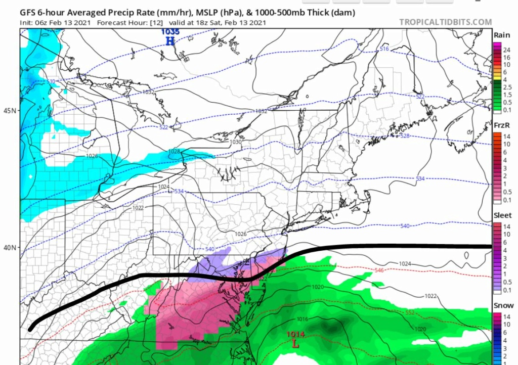
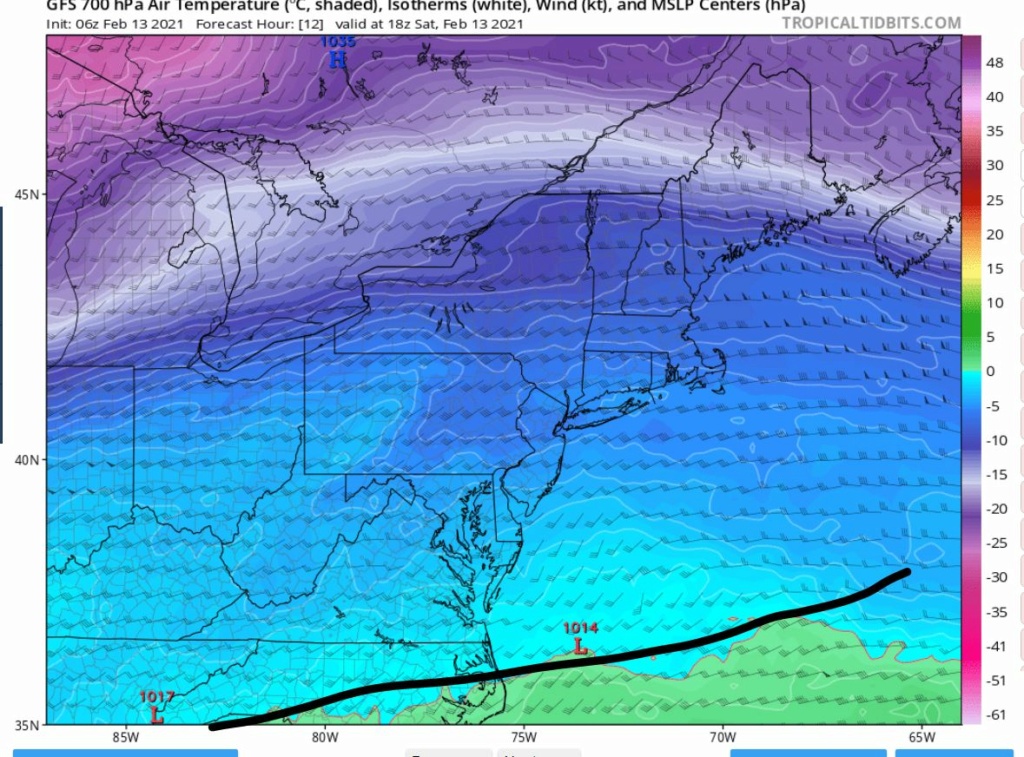
NOT freezing closer to the surface at the 850 level:
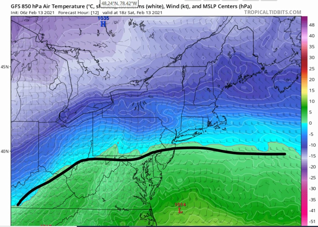
And then freezing again at the surface:
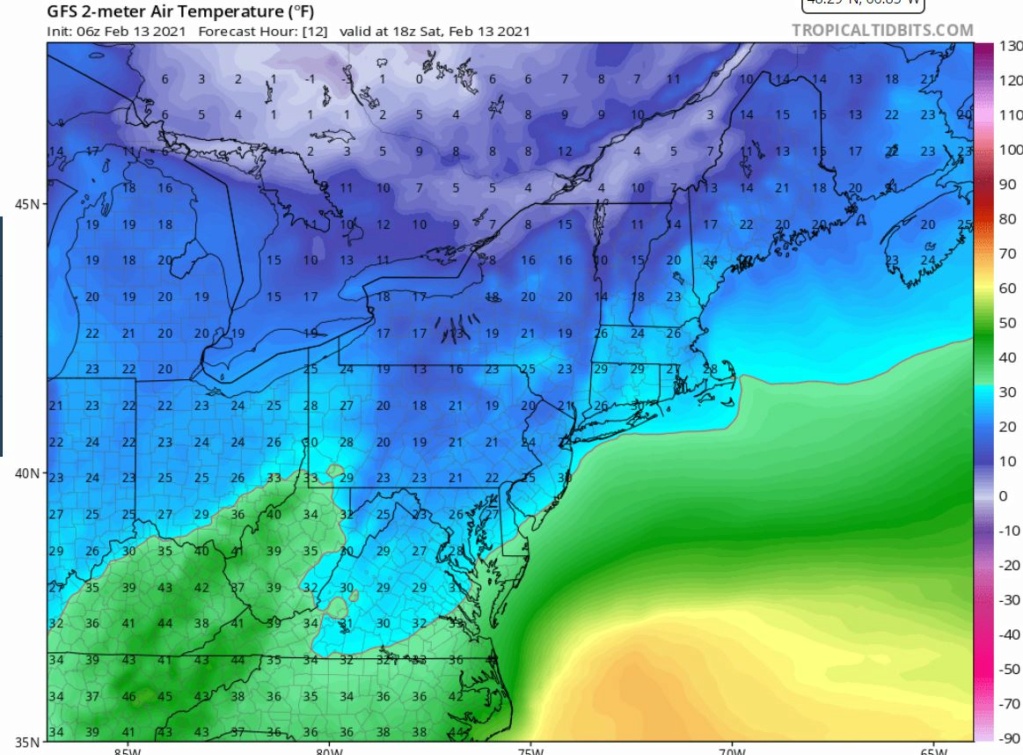
Hope that warm nose backs down, but no one seems too hopeful of that...
Freezing at higher levels (500mb and 700mb):


NOT freezing closer to the surface at the 850 level:

And then freezing again at the surface:

Hope that warm nose backs down, but no one seems too hopeful of that...
SENJsnowman- Senior Enthusiast

- Posts : 1189
Reputation : 61
Join date : 2017-01-06
Age : 51
Location : Bayville, NJ
 Re: FEB 13th-16th Snow, Ice and Rain
The largest ice threat for Monday night and Tuesday remains EPA, NEPA, LHV and NW NJ. Models have trended warmer and every little bit will help with the severity of the threat. Nonetheless significant to severe icing is possible in those areas. I don't think coastal plain or the immediate I-95 will have significant icing, but maybe some though.
heehaw453- Advanced Forecaster

- Posts : 3906
Reputation : 86
Join date : 2014-01-20
Location : Bedminster Township, PA Elevation 600' ASL
 Re: FEB 13th-16th Snow, Ice and Rain
SENJsnowman wrote:If I'm reading these maps right, I guess this is a pretty understandable recipe for a freezing rain/ice storm (for 3 pm today):
Freezing at higher levels (500mb and 700mb):
NOT freezing closer to the surface at the 850 level:
And then freezing again at the surface:
Hope that warm nose backs down, but no one seems too hopeful of that...
I can see some ice glazing today in the coastal plain. I think further north and west you go it's more sleet and possibly mixed with a bit of snow.
heehaw453- Advanced Forecaster

- Posts : 3906
Reputation : 86
Join date : 2014-01-20
Location : Bedminster Township, PA Elevation 600' ASL
 Re: FEB 13th-16th Snow, Ice and Rain
Yea, this is definitely trending warmer for the coast and N&W, which means N&W is now in the “ice threat” zone. But if this keeps trending we’re all looking at 35 degrees and a plain rain.
_________________
_______________________________________________________________________________________________________
CLICK HERE to view NJ Strong Snowstorm Classifications
 Re: FEB 13th-16th Snow, Ice and Rain
Frank_Wx wrote:Yea, this is definitely trending warmer for the coast and N&W, which means N&W is now in the “ice threat” zone. But if this keeps trending we’re all looking at 35 degrees and a plain rain.
That would be my wish actually.
heehaw453- Advanced Forecaster

- Posts : 3906
Reputation : 86
Join date : 2014-01-20
Location : Bedminster Township, PA Elevation 600' ASL
elkiehound likes this post
 Re: FEB 13th-16th Snow, Ice and Rain
What happens with the first two impulses of energy will determine where the Boundary layer sets up.
And what the HP does over Canada. Any slight shift will change things for our area- ice to rain, all ice, snow n ice etc.
Tricky forecast.
Convinced now- Ray is the Mush !!! Hw comes in here after we had a great stretch of winter wx and what looked like a MECS is going to pot!
Luv you Raymond LOL!
And what the HP does over Canada. Any slight shift will change things for our area- ice to rain, all ice, snow n ice etc.
Tricky forecast.
Convinced now- Ray is the Mush !!! Hw comes in here after we had a great stretch of winter wx and what looked like a MECS is going to pot!
Luv you Raymond LOL!
_________________
Mugs
AKA:King: Snow Weenie
Self Proclaimed
WINTER 2014-15 : 55.12" +.02 for 6 coatings (avg. 35")
WINTER 2015-16 Total - 29.8" (Avg 35")
WINTER 2016-17 : 39.5" so far

amugs- Advanced Forecaster - Mod

- Posts : 15095
Reputation : 213
Join date : 2013-01-07
Age : 54
Location : Hillsdale,NJ
 Re: FEB 13th-16th Snow, Ice and Rain
amugs wrote:What happens with the first two impulses of energy will determine where the Boundary layer sets up.
And what the HP does over Canada. Any slight shift will change things for our area- ice to rain, all ice, snow n ice etc.
Tricky forecast.
Convinced now- Ray is the Mush !!! Hw comes in here after we had a great stretch of winter wx and what looked like a MECS is going to pot!
Luv you Raymond LOL!
Are we voting to ban him?
_________________
_______________________________________________________________________________________________________
CLICK HERE to view NJ Strong Snowstorm Classifications
 Re: FEB 13th-16th Snow, Ice and Rain
NAM makes me sad


_________________
_______________________________________________________________________________________________________
CLICK HERE to view NJ Strong Snowstorm Classifications
 Re: FEB 13th-16th Snow, Ice and Rain
So are we now just getting rain for tonight into tomorrow as well as Monday into Tuesday? Just wondering with all the confusion from the models. Will it be safe to be on the roads tonight?
Fededle22- Posts : 169
Reputation : 2
Join date : 2013-03-08
Location : West Orange, NJ
 Re: FEB 13th-16th Snow, Ice and Rain
GFS and NAM put us out of the picture for snow and any ice concerns with lovely rain to wash away all our nice snow.

jmanley32- Senior Enthusiast

- Posts : 20535
Reputation : 108
Join date : 2013-12-12
Age : 43
Location : Yonkers, NY
elkiehound likes this post
 Re: FEB 13th-16th Snow, Ice and Rain
Want a irish car bomb? That will make you forget what you have seen. It does suck, I know it was said snow threat is not gone but do these models shift back several hundred miles SE to bring it to where we can snow> Doesnt look likely to me.Frank_Wx wrote:NAM makes me sad
Am I good for today and tomorrow, I am confused as there is a WWA for the bronx but not here and thats less than miles from me, is it really going to be that sharp of a cut off for the inch of snow and .10 ice? Or has upton just not pulled the trigger?

jmanley32- Senior Enthusiast

- Posts : 20535
Reputation : 108
Join date : 2013-12-12
Age : 43
Location : Yonkers, NY
 Re: FEB 13th-16th Snow, Ice and Rain
Fededle22 wrote:So are we now just getting rain for tonight into tomorrow as well as Monday into Tuesday? Just wondering with all the confusion from the models. Will it be safe to be on the roads tonight?
Not much weather is happening over the next 48 hours. The jersey shore, NYC and LI may see some sleet later today into early evening hours, but it’s very light and i don’t see it causing too many issues. The bigger storm moves in Monday but it’s looking like a plain rain. Models are struggling because they can’t figure out the block to the north. If there was a good block then we wouldn’t see the primary low cut to our west. It would do something like the Roodzilla storm where it attempts to cut but the block forces a transfer to the coast. In this scenario, there is a transfer but it’s way too late. That’s because the block is too far north and or weak. Check it out

Lack of 50/50 low and an Atlantic ridge that is expanding into the east coast. It’s a very bad setup for snow.

_________________
_______________________________________________________________________________________________________
CLICK HERE to view NJ Strong Snowstorm Classifications
 Re: FEB 13th-16th Snow, Ice and Rain
“ looking like a plain rain”... For the whole area?

elkiehound- Posts : 56
Reputation : 1
Join date : 2013-12-09
Location : Ringoes NJ
 Re: FEB 13th-16th Snow, Ice and Rain
from looking at the models and no analysis yes it looks like the majority of the area except maybe mickey P and Math.elkiehound wrote:“ looking like a plain rain”... For the whole area?

jmanley32- Senior Enthusiast

- Posts : 20535
Reputation : 108
Join date : 2013-12-12
Age : 43
Location : Yonkers, NY
elkiehound likes this post
 Re: FEB 13th-16th Snow, Ice and Rain
Unless the Monday storm keeps pushing west, I think I'll do okay with that one. It doesn't look like anybody wins with that second system. Frank mentioned it earlier: that high is all over the place. What exactly causes such erratic movement in a high like that?
TheAresian- Senior Enthusiast

- Posts : 145
Reputation : 10
Join date : 2019-11-13
Location : Painted Post, NY
 Re: FEB 13th-16th Snow, Ice and Rain
So it seems we should skip the generator check, but it may be a good time clear snow and ice from gutters and leaders pipes for the coming rain.
A fast freeze Tuesday night makes it even more important to get everything drained away as quickly as possible.
A fast freeze Tuesday night makes it even more important to get everything drained away as quickly as possible.

essexcountypete- Pro Enthusiast

- Posts : 783
Reputation : 12
Join date : 2013-12-09
Location : Bloomfield, NJ
Page 3 of 10 •  1, 2, 3, 4, 5, 6, 7, 8, 9, 10
Page 3 of 10
Permissions in this forum:
You cannot reply to topics in this forum|
|
|

 Home
Home