
 Search
FEB 13th-16th Snow, Ice and Rain
Page 2 of 10 •  1, 2, 3, 4, 5, 6, 7, 8, 9, 10
 ![]()
Re: FEB 13th-16th Snow, Ice and Rain
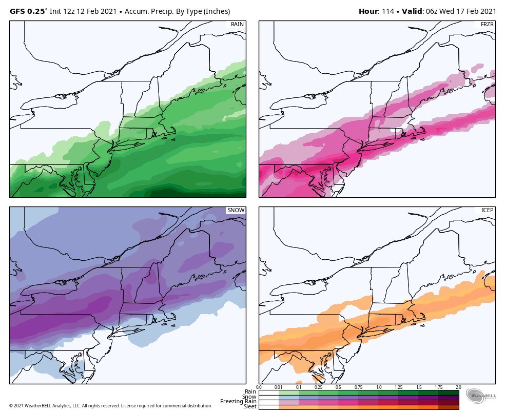
![]() by TheAresian Fri Feb 12, 2021 11:24 am
by TheAresian Fri Feb 12, 2021 11:24 am
heehaw453 wrote:The 12Z GFS shows just how precarious this is right now. The baroclinic zone sets up shop just a little (150 miles) to our NW. The mid level storms are a bit too far north too since the zone sets up too far north. Taken verbatim the threat is ice from this and not too much snow unless you're well north of I-84 or I-81 above Scranton.
I think the threat for severe icing is NW of I-95 is real because I believe mid-levels (4000-5000 feet ASL) are going to torch, but low level coldness will hold strong NW of I-95.
I've seen this movie before and it usually has a bad ending.
I know it's a little too far out to be looking at right now, but it looks like this movie might have a sequel a few days later. How can what happens this storm impact what happens next storm, if at all?
TheAresian- Senior Enthusiast

- Posts : 145
Join date : 2019-11-13
Re: FEB 13th-16th Snow, Ice and Rain
![]() by amugs Fri Feb 12, 2021 11:31 am
by amugs Fri Feb 12, 2021 11:31 am
Both storms 12 Z GFS - amazing we went from a full blown snowstorm to a slop fest - MJO wave 7 at play here and moderate Nina in Feb(?)
As Walt Drag has said he believes the snow axis is the I 84 and North Corridor. /interior. I personally do not like this trend - we were to have a piece of PV just west of us in the Lake Michigan area to Erie that would have pushed the cold deep into the MA, we have it stuck in the Plains and it tries to bleed east with very cold air over the top. We have as Scott pointed out a MJO wave in Phase 7 which in a NINA is warm but the -AO/NAO couplet has fought that off for weeks now. It’s been a moderate Nina, we have the AO and NAO retreating and allowing more SE Ridge. We have lost basically 3 storms this week that WERE showing SECS plus snowstorms, did we snow yes but not nearly to the advertisement of the models (plural).
GFS a show snizzle and even rain on Sunday into Monday now and then after the storm departs we go into single digits that night = rapid freeze?
Time will tell but the trends are not there for a snowstorm but rather an ice storm at this time
amugs- Advanced Forecaster - Mod

- Posts : 15095
Join date : 2013-01-07
Re: FEB 13th-16th Snow, Ice and Rain
![]() by amugs Fri Feb 12, 2021 11:36 am
by amugs Fri Feb 12, 2021 11:36 am
aiannone wrote:
Temps during heaviest precip


Aye Caramba after teh storm Jesus mother of mercy cold

_________________
Mugs
AKA:King: Snow Weenie
Self Proclaimed
WINTER 2014-15 : 55.12" +.02 for 6 coatings (avg. 35")
WINTER 2015-16 Total - 29.8" (Avg 35")
WINTER 2016-17 : 39.5" so far

amugs- Advanced Forecaster - Mod
- Posts : 15095
Reputation : 213
Join date : 2013-01-07
Age : 54
Location : Hillsdale,NJ
Re: FEB 13th-16th Snow, Ice and Rain
![]() by heehaw453 Fri Feb 12, 2021 11:41 am
by heehaw453 Fri Feb 12, 2021 11:41 am
amugs wrote:
Both storms 12 Z GFS - amazing we went from a full blown snowstorm to a slop fest - MJO wave 7 at play here and moderate Nina in Feb(?)
As Walt Drag has said he believes the snow axis is the I 84 and North Corridor. /interior. I personally do not like this trend - we were to have a piece of PV just west of us in the Lake Michigan area to Erie that would have pushed the cold deep into the MA, we have it stuck in the Plains and it tries to bleed east with very cold air over the top. We have as Scott pointed out a MJO wave in Phase 7 which in a NINA is warm but the -AO/NAO couplet has fought that off for weeks now. It’s been a moderate Nina, we have the AO and NAO retreating and allowing more SE Ridge. We have lost basically 3 storms this week that WERE showing SECS plus snowstorms, did we snow yes but not nearly to the advertisement of the models (plural).
GFS a show snizzle and even rain on Sunday into Monday now and then after the storm departs we go into single digits that night = rapid freeze?
Time will tell but the trends are not there for a snowstorm but rather an ice storm at this time
I believe the GFS is being too far south with the icing. I think if you move what it's showing about 50/75 miles NW that's where the bulls eye for ice will be. The setup screams EPA/NEPA, NW NJ and LHV for ice to me. I could also see North Shore of LI getting iced. I think sig snows are closer to MHV and closer to Poughkeepsie. I truly hope I'm wrong.
heehaw453- Advanced Forecaster

- Posts : 3906
Reputation : 86
Join date : 2014-01-20
Location : Bedminster Township, PA Elevation 600' ASL
Re: FEB 13th-16th Snow, Ice and Rain
![]() by amugs Fri Feb 12, 2021 11:42 am
by amugs Fri Feb 12, 2021 11:42 am
CMC

GFS

GEFS

This allows the storm to cut to our west a bit more rushing in the warm air, cold will hold on but not for long with this.

_________________
Mugs
AKA:King: Snow Weenie
Self Proclaimed
WINTER 2014-15 : 55.12" +.02 for 6 coatings (avg. 35")
WINTER 2015-16 Total - 29.8" (Avg 35")
WINTER 2016-17 : 39.5" so far
amugs- Advanced Forecaster - Mod
- Posts : 15095
Reputation : 213
Join date : 2013-01-07
Age : 54
Location : Hillsdale,NJ
Re: FEB 13th-16th Snow, Ice and Rain
![]() by heehaw453 Fri Feb 12, 2021 11:46 am
by heehaw453 Fri Feb 12, 2021 11:46 am
heehaw453- Advanced Forecaster
- Posts : 3906
Reputation : 86
Join date : 2014-01-20
Location : Bedminster Township, PA Elevation 600' ASL
Re: FEB 13th-16th Snow, Ice and Rain
![]() by amugs Fri Feb 12, 2021 11:49 am
by amugs Fri Feb 12, 2021 11:49 am
I78/80 N for icing the trends are not good for wintry weather and I know some will rejoice if it plain rain but will also cry when they see the EPO go Positive and AO and NAO retreat with MJO wave in 7 looking to circle into 6. Not there yet of course.heehaw453 wrote:amugs wrote:
Both storms 12 Z GFS - amazing we went from a full blown snowstorm to a slop fest - MJO wave 7 at play here and moderate Nina in Feb(?)
As Walt Drag has said he believes the snow axis is the I 84 and North Corridor. /interior. I personally do not like this trend - we were to have a piece of PV just west of us in the Lake Michigan area to Erie that would have pushed the cold deep into the MA, we have it stuck in the Plains and it tries to bleed east with very cold air over the top. We have as Scott pointed out a MJO wave in Phase 7 which in a NINA is warm but the -AO/NAO couplet has fought that off for weeks now. It’s been a moderate Nina, we have the AO and NAO retreating and allowing more SE Ridge. We have lost basically 3 storms this week that WERE showing SECS plus snowstorms, did we snow yes but not nearly to the advertisement of the models (plural).
GFS a show snizzle and even rain on Sunday into Monday now and then after the storm departs we go into single digits that night = rapid freeze?
Time will tell but the trends are not there for a snowstorm but rather an ice storm at this time
I believe the GFS is being too far south with the icing. I think if you move what it's showing about 50/75 miles NW that's where the bulls eye for ice will be. The setup screams EPA/NEPA, NW NJ and LHV for ice to me. I could also see North Shore of LI getting iced. I think sig snows are closer to MHV and closer to Poughkeepsie. I truly hope I'm wrong.
We have to see how they handle this next feature which seems to be dying out as well. Sorry but not all into this as I see it now going to be a headache for sure but lets see how the next set of model runs go through 6Z manana morning. Model dance at play - need a huge 100 mile jump SE to salvage many from slop and ice.
_________________
Mugs
AKA:King: Snow Weenie
Self Proclaimed
WINTER 2014-15 : 55.12" +.02 for 6 coatings (avg. 35")
WINTER 2015-16 Total - 29.8" (Avg 35")
WINTER 2016-17 : 39.5" so far
amugs- Advanced Forecaster - Mod
- Posts : 15095
Reputation : 213
Join date : 2013-01-07
Age : 54
Location : Hillsdale,NJ
Re: FEB 13th-16th Snow, Ice and Rain
![]() by sroc4 Fri Feb 12, 2021 11:59 am
by sroc4 Fri Feb 12, 2021 11:59 am
_________________
"In weather and in life, there's no winning and losing; there's only winning and learning."
WINTER 2012/2013 TOTALS 43.65"WINTER 2017/2018 TOTALS 62.85" WINTER 2022/2023 TOTALS 4.9"
WINTER 2013/2014 TOTALS 64.85"WINTER 2018/2019 TOTALS 14.25" WINTER 2023/2024 TOTALS 13.1"
WINTER 2014/2015 TOTALS 71.20"WINTER 2019/2020 TOTALS 6.35"
WINTER 2015/2016 TOTALS 35.00"WINTER 2020/2021 TOTALS 37.75"
WINTER 2016/2017 TOTALS 42.25"WINTER 2021/2022 TOTALS 31.65"

sroc4- Admin

- Posts : 8354
Reputation : 302
Join date : 2013-01-07
Location : Wading River, LI
amugs and heehaw453 like this post
Re: FEB 13th-16th Snow, Ice and Rain
![]() by bobjohnsonforthehall Fri Feb 12, 2021 12:16 pm
by bobjohnsonforthehall Fri Feb 12, 2021 12:16 pm

bobjohnsonforthehall- Posts : 311
Reputation : 19
Join date : 2016-10-02
Location : Flemington NJ
Re: FEB 13th-16th Snow, Ice and Rain
![]() by algae888 Fri Feb 12, 2021 12:24 pm
by algae888 Fri Feb 12, 2021 12:24 pm

algae888- Advanced Forecaster
- Posts : 5311
Reputation : 46
Join date : 2013-02-05
Age : 62
Location : mt. vernon, new york
Re: FEB 13th-16th Snow, Ice and Rain
![]() by heehaw453 Fri Feb 12, 2021 12:28 pm
by heehaw453 Fri Feb 12, 2021 12:28 pm
sroc4 wrote:Every 12z thus far has been drastically diff from one another at 500. I mean night and day different between one key feature or another. I think we are going to need to be patient on this one.
100% Agree. I also think the Saturday night wave offshore will affect how east the High positions itself. Just don't care one bit for today's model runs from any of the providers.
heehaw453- Advanced Forecaster
- Posts : 3906
Reputation : 86
Join date : 2014-01-20
Location : Bedminster Township, PA Elevation 600' ASL
sroc4 likes this post
Re: FEB 13th-16th Snow, Ice and Rain
![]() by sroc4 Fri Feb 12, 2021 12:59 pm
by sroc4 Fri Feb 12, 2021 12:59 pm
bobjohnsonforthehall wrote:What is the start time for whatever falls? Flemington area anyway.
Too much variability for me to say at this point Bob.
_________________
"In weather and in life, there's no winning and losing; there's only winning and learning."
WINTER 2012/2013 TOTALS 43.65"WINTER 2017/2018 TOTALS 62.85" WINTER 2022/2023 TOTALS 4.9"
WINTER 2013/2014 TOTALS 64.85"WINTER 2018/2019 TOTALS 14.25" WINTER 2023/2024 TOTALS 13.1"
WINTER 2014/2015 TOTALS 71.20"WINTER 2019/2020 TOTALS 6.35"
WINTER 2015/2016 TOTALS 35.00"WINTER 2020/2021 TOTALS 37.75"
WINTER 2016/2017 TOTALS 42.25"WINTER 2021/2022 TOTALS 31.65"
sroc4- Admin
- Posts : 8354
Reputation : 302
Join date : 2013-01-07
Location : Wading River, LI
Re: FEB 13th-16th Snow, Ice and Rain
![]() by jmanley32 Fri Feb 12, 2021 1:33 pm
by jmanley32 Fri Feb 12, 2021 1:33 pm
If the ice line on GFS moves 75 miles north that will put my area in the thick of it, never seen that much fzr before and i am sure it would be aweful, gonna hold off on buying any perishables until closer to tuesday as this is a very volitile set up as scott stated.heehaw453 wrote:amugs wrote:
Both storms 12 Z GFS - amazing we went from a full blown snowstorm to a slop fest - MJO wave 7 at play here and moderate Nina in Feb(?)
As Walt Drag has said he believes the snow axis is the I 84 and North Corridor. /interior. I personally do not like this trend - we were to have a piece of PV just west of us in the Lake Michigan area to Erie that would have pushed the cold deep into the MA, we have it stuck in the Plains and it tries to bleed east with very cold air over the top. We have as Scott pointed out a MJO wave in Phase 7 which in a NINA is warm but the -AO/NAO couplet has fought that off for weeks now. It’s been a moderate Nina, we have the AO and NAO retreating and allowing more SE Ridge. We have lost basically 3 storms this week that WERE showing SECS plus snowstorms, did we snow yes but not nearly to the advertisement of the models (plural).
GFS a show snizzle and even rain on Sunday into Monday now and then after the storm departs we go into single digits that night = rapid freeze?so should I prepare for a severe ice storm with outages etc, ill eat all our perishables b4 tursday as we havent gone shop yet and ill get canned goods instead, 50-75 miles north is right over me, seems I have been in the sweet spot (not so much for this) in all storms.
Time will tell but the trends are not there for a snowstorm but rather an ice storm at this time
I believe the GFS is being too far south with the icing. I think if you move what it's showing about 50/75 miles NW that's where the bulls eye for ice will be. The setup screams EPA/NEPA, NW NJ and LHV for ice to me. I could also see North Shore of LI getting iced. I think sig snows are closer to MHV and closer to Poughkeepsie. I truly hope I'm wrong.

jmanley32- Senior Enthusiast
- Posts : 20535
Reputation : 108
Join date : 2013-12-12
Age : 43
Location : Yonkers, NY
Re: FEB 13th-16th Snow, Ice and Rain
![]() by heehaw453 Fri Feb 12, 2021 1:46 pm
by heehaw453 Fri Feb 12, 2021 1:46 pm
heehaw453- Advanced Forecaster
- Posts : 3906
Reputation : 86
Join date : 2014-01-20
Location : Bedminster Township, PA Elevation 600' ASL
Re: FEB 13th-16th Snow, Ice and Rain
![]() by heehaw453 Fri Feb 12, 2021 1:55 pm
by heehaw453 Fri Feb 12, 2021 1:55 pm

heehaw453- Advanced Forecaster
- Posts : 3906
Reputation : 86
Join date : 2014-01-20
Location : Bedminster Township, PA Elevation 600' ASL
Re: FEB 13th-16th Snow, Ice and Rain
![]() by phil155 Fri Feb 12, 2021 1:57 pm
by phil155 Fri Feb 12, 2021 1:57 pm
phil155- Pro Enthusiast

- Posts : 483
Reputation : 4
Join date : 2019-12-16
Re: FEB 13th-16th Snow, Ice and Rain
![]() by heehaw453 Fri Feb 12, 2021 2:00 pm
by heehaw453 Fri Feb 12, 2021 2:00 pm
phil155 wrote:might be a foolish question and for that I apologize but for areas closer to I-95 what is the general thinking at this point or is it still too soon to have a real clear idea
Not a foolish question at all. I wish I knew, but I believe I-95 is also under an ice threat with this. I'd say Jersey Shore/NYC not so much but anything along and NW I-95 is under a threat for ice, possibly severe the further NW you go.
heehaw453- Advanced Forecaster
- Posts : 3906
Reputation : 86
Join date : 2014-01-20
Location : Bedminster Township, PA Elevation 600' ASL
phil155 likes this post
Re: FEB 13th-16th Snow, Ice and Rain
![]() by jmanley32 Fri Feb 12, 2021 2:21 pm
by jmanley32 Fri Feb 12, 2021 2:21 pm
so rain for coast on that run but drop that red 20 miles south and I'm in trouble as well as many. That's bad for doc and cp as they live in a lot of treed areas. I do too but not as much as up there. I think this is gonna end up being somewhat on a now cast. We haven't seen a ice warning in these parts in any time that I recall. 1994 I was in CT too far back to remember.heehaw453 wrote:Terrible scenario right here. I also think the Euro is way too warm at the surface and think it's going to be much colder as I think the H will be further east supplying colder air.
jmanley32- Senior Enthusiast
- Posts : 20535
Reputation : 108
Join date : 2013-12-12
Age : 43
Location : Yonkers, NY
Re: FEB 13th-16th Snow, Ice and Rain
![]() by elkiehound Fri Feb 12, 2021 2:26 pm
by elkiehound Fri Feb 12, 2021 2:26 pm

elkiehound- Posts : 56
Reputation : 1
Join date : 2013-12-09
Location : Ringoes NJ
Re: FEB 13th-16th Snow, Ice and Rain
![]() by TheAresian Fri Feb 12, 2021 2:45 pm
by TheAresian Fri Feb 12, 2021 2:45 pm
TheAresian- Senior Enthusiast
- Posts : 145
Reputation : 10
Join date : 2019-11-13
Location : Painted Post, NY
elkiehound likes this post
Re: FEB 13th-16th Snow, Ice and Rain
![]() by heehaw453 Fri Feb 12, 2021 3:15 pm
by heehaw453 Fri Feb 12, 2021 3:15 pm

heehaw453- Advanced Forecaster
- Posts : 3906
Reputation : 86
Join date : 2014-01-20
Location : Bedminster Township, PA Elevation 600' ASL
Re: FEB 13th-16th Snow, Ice and Rain
![]() by TheAresian Fri Feb 12, 2021 3:53 pm
by TheAresian Fri Feb 12, 2021 3:53 pm
TheAresian- Senior Enthusiast
- Posts : 145
Reputation : 10
Join date : 2019-11-13
Location : Painted Post, NY
Re: FEB 13th-16th Snow, Ice and Rain
![]() by lglickman1 Fri Feb 12, 2021 3:58 pm
by lglickman1 Fri Feb 12, 2021 3:58 pm
lglickman1- Pro Enthusiast
- Posts : 319
Reputation : 0
Join date : 2013-02-05
Location : New Rochelle, NY
Re: FEB 13th-16th Snow, Ice and Rain
![]() by SENJsnowman Fri Feb 12, 2021 3:59 pm
by SENJsnowman Fri Feb 12, 2021 3:59 pm
SENJsnowman- Senior Enthusiast
- Posts : 1189
Reputation : 61
Join date : 2017-01-06
Age : 51
Location : Bayville, NJ
Re: FEB 13th-16th Snow, Ice and Rain
![]() by jimv45 Fri Feb 12, 2021 4:09 pm
by jimv45 Fri Feb 12, 2021 4:09 pm
jimv45- Senior Enthusiast
- Posts : 1168
Reputation : 36
Join date : 2013-09-20
Location : Hopewell jct.
Re: FEB 13th-16th Snow, Ice and Rain
![]() by sroc4 Fri Feb 12, 2021 4:42 pm
by sroc4 Fri Feb 12, 2021 4:42 pm
lglickman1 wrote:So is the chance of all snow down to the coast long gone?
No not gone
_________________
"In weather and in life, there's no winning and losing; there's only winning and learning."
WINTER 2012/2013 TOTALS 43.65"WINTER 2017/2018 TOTALS 62.85" WINTER 2022/2023 TOTALS 4.9"
WINTER 2013/2014 TOTALS 64.85"WINTER 2018/2019 TOTALS 14.25" WINTER 2023/2024 TOTALS 13.1"
WINTER 2014/2015 TOTALS 71.20"WINTER 2019/2020 TOTALS 6.35"
WINTER 2015/2016 TOTALS 35.00"WINTER 2020/2021 TOTALS 37.75"
WINTER 2016/2017 TOTALS 42.25"WINTER 2021/2022 TOTALS 31.65"
sroc4- Admin
- Posts : 8354
Reputation : 302
Join date : 2013-01-07
Location : Wading River, LI
Re: FEB 13th-16th Snow, Ice and Rain
![]() by jmanley32 Fri Feb 12, 2021 4:57 pm
by jmanley32 Fri Feb 12, 2021 4:57 pm
jmanley32- Senior Enthusiast
- Posts : 20535
Reputation : 108
Join date : 2013-12-12
Age : 43
Location : Yonkers, NY
Page 2 of 10 • 1, 2, 3, 4, 5, 6, 7, 8, 9, 10 ![]()
|
|
|