February 25th 2022 potential snow/ice for mainly well NW of I95
+30
dkodgis
mmanisca
Radz
2004blackwrx
WeatherBob
Frozen.9
1190ftalt
Taffy
essexcountypete
Sparky Sparticles
weatherwatchermom
SkiSeadooJoe
Snow88
brownie
RJB8525
SENJsnowman
Quietace
snowbunny
algae888
billg315
aiannone
sroc4
docstox12
jimv45
hyde345
amugs
frank 638
Frank_Wx
jmanley32
heehaw453
34 posters
Page 1 of 9 • 1, 2, 3, 4, 5, 6, 7, 8, 9 
 February 25th 2022 potential snow/ice for mainly well NW of I95
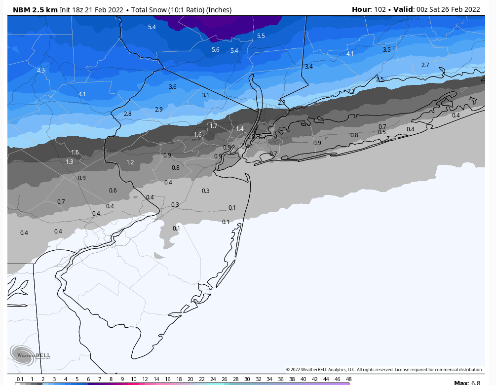
Potential snow/ice event for mainly well NW of I-95. NW NJ/LHV/NEPA and especially MHV.
heehaw453- Advanced Forecaster

- Posts : 3906
Reputation : 86
Join date : 2014-01-20
Location : Bedminster Township, PA Elevation 600' ASL
 Re: February 25th 2022 potential snow/ice for mainly well NW of I95
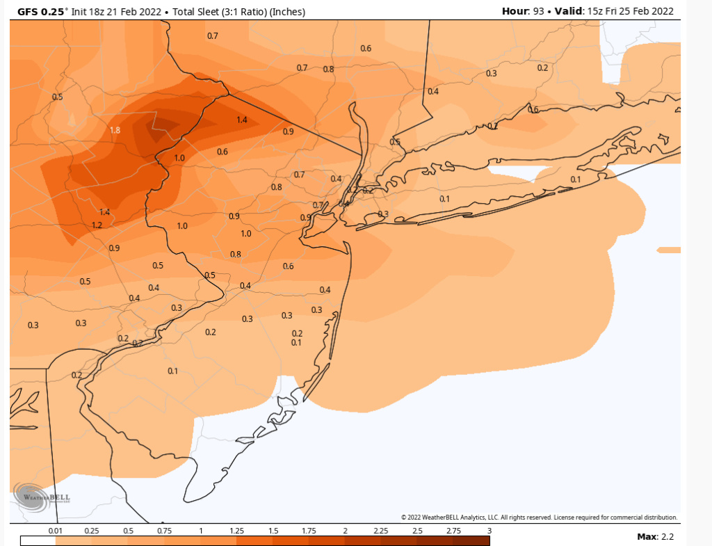
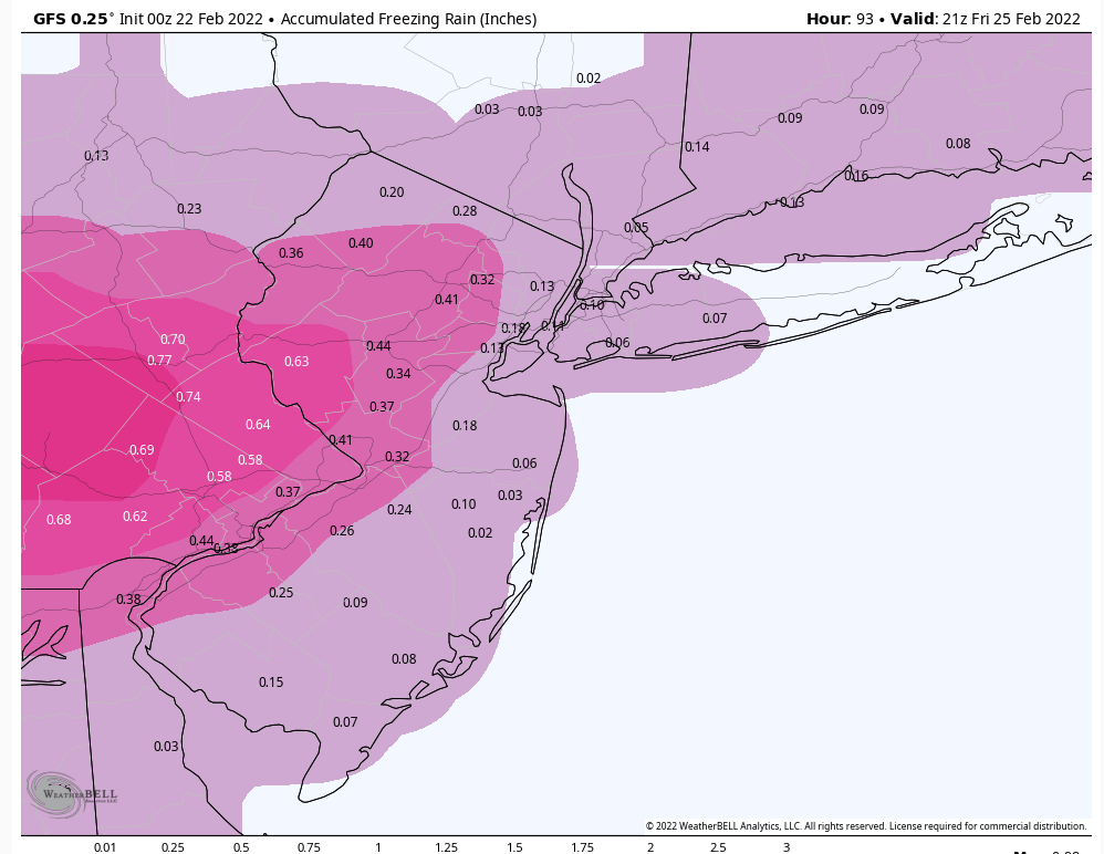
Didn't you say yesterday your thinking was I 195 and 1-80 for ice? Now it is well north of I-95? Make up ur mind LOL JK, just confused you changed it overnight. GFS shows pretty bad ice for NNJ across NYC and just north, do you think that continues north and NYC etc just sees rain?

jmanley32- Senior Enthusiast

- Posts : 20535
Reputation : 108
Join date : 2013-12-12
Age : 43
Location : Yonkers, NY
 Re: February 25th 2022 potential snow/ice for mainly well NW of I95
jmanley32 wrote:Didn't you say yesterday your thinking was I 195 and 1-80 for ice? Now it is well north of I-95? Make up ur mind LOL JK, just confused you changed it overnight. GFS shows pretty bad ice for NNJ across NYC and just north, do you think that continues north and NYC etc just sees rain?
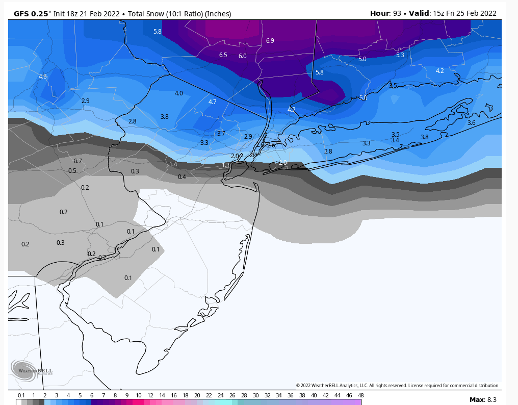
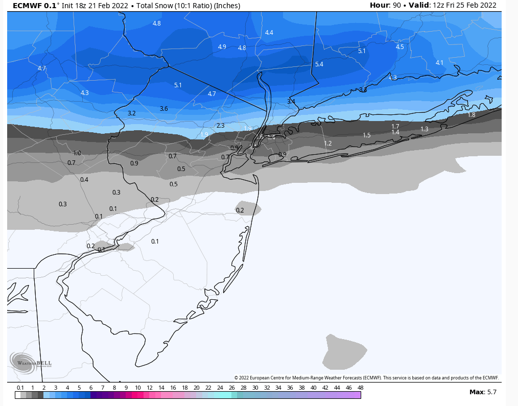
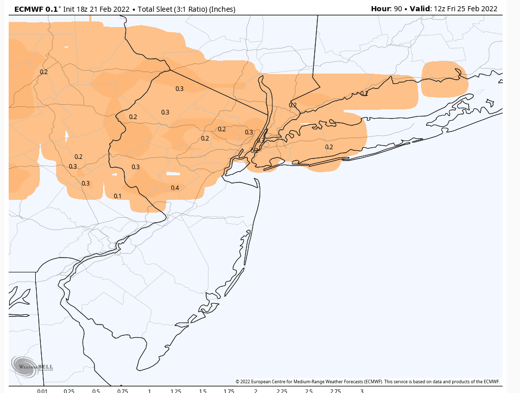
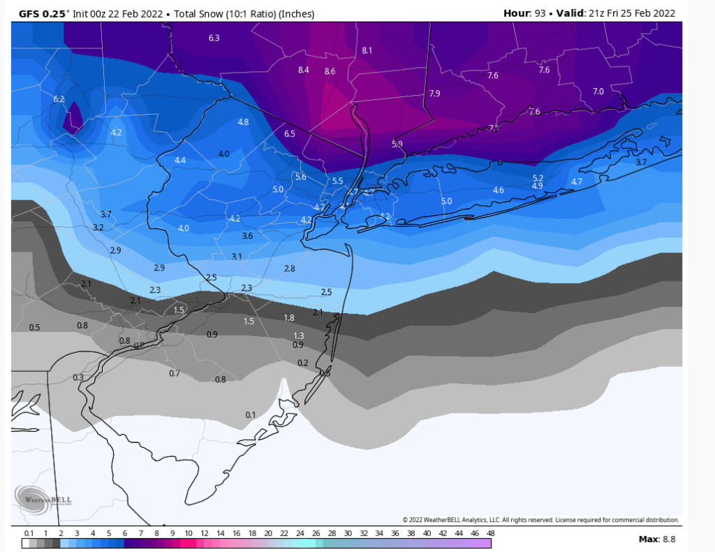
All good JMan. Too early for granular details and it's more coarse grain now. But I'd say zr/sleet threat interior areas of I-78-I-80 (~.25" ice), sleet with some snow I-80-I-84 (2-4"), and snow with some sleet into the MHV past I-84 (4"+). Also, areas where I see greater than 4" snowfall potential are elevated areas NEPA/NW NJ > 1200' ASL.
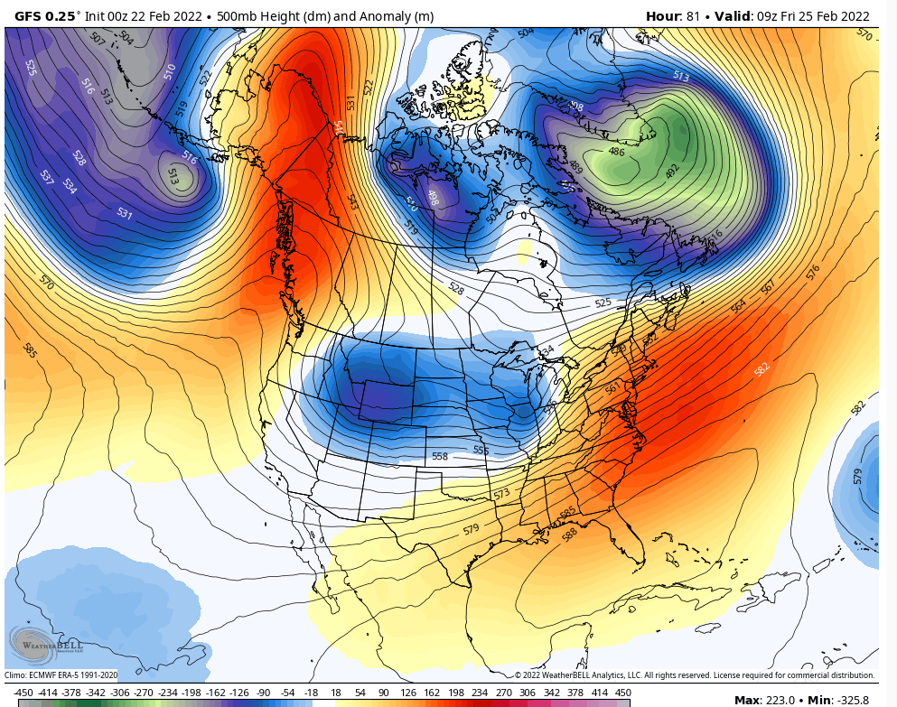
If the SE ridge is stronger than modelled than all that gets pushed further north accordingly. Conversely if the SE ridge is beaten down a bit more then slide it further south a bit. My thought now is stronger SE ridge with stronger and further N low pressure. But I'll hedge for now.
heehaw453- Advanced Forecaster

- Posts : 3906
Reputation : 86
Join date : 2014-01-20
Location : Bedminster Township, PA Elevation 600' ASL
 Re: February 25th 2022 potential snow/ice for mainly well NW of I95
You can probably tell from my lack of posting, but I'm not particularly excited about this one.
Very positive NAO and not much help to bring the cold air down toward the coast. My guess is a low track over or just west of us.
Very positive NAO and not much help to bring the cold air down toward the coast. My guess is a low track over or just west of us.
_________________
_______________________________________________________________________________________________________
CLICK HERE to view NJ Strong Snowstorm Classifications
heehaw453 and JT33 like this post
 Re: February 25th 2022 potential snow/ice for mainly well NW of I95
Your biggest totals 6-10" IMO will be north of I-90 from Albany, VT, NH, SE ME. That to me is the sweet spot.
heehaw453- Advanced Forecaster

- Posts : 3906
Reputation : 86
Join date : 2014-01-20
Location : Bedminster Township, PA Elevation 600' ASL
 Re: February 25th 2022 potential snow/ice for mainly well NW of I95
So I’m guessing for the city we are probably looking at snow to wintry mix to rain with A little Snow accumulation
frank 638- Senior Enthusiast

- Posts : 2843
Reputation : 37
Join date : 2016-01-01
Age : 40
Location : bronx ny
 Re: February 25th 2022 potential snow/ice for mainly well NW of I95
I dunno if we see any prozen precip from what I am hearing, maybe frz. I could be wrong but if Frank is not enthused and VT is getting the goods I could care less lol.frank 638 wrote:So I’m guessing for the city we are probably looking at snow to wintry mix to rain with A little Snow accumulation

jmanley32- Senior Enthusiast

- Posts : 20535
Reputation : 108
Join date : 2013-12-12
Age : 43
Location : Yonkers, NY
heehaw453- Advanced Forecaster

- Posts : 3906
Reputation : 86
Join date : 2014-01-20
Location : Bedminster Township, PA Elevation 600' ASL
sroc4 likes this post
 Re: February 25th 2022 potential snow/ice for mainly well NW of I95
As Bob said the CAD will be there with the Arctic front. Yes +NAO and a shame because it would have forced this to belly under and give us a SECS to MECS. Now we do not have that but we may have a pretty good wintry mix event from I 80 N.
_________________
Mugs
AKA:King: Snow Weenie
Self Proclaimed
WINTER 2014-15 : 55.12" +.02 for 6 coatings (avg. 35")
WINTER 2015-16 Total - 29.8" (Avg 35")
WINTER 2016-17 : 39.5" so far

amugs- Advanced Forecaster - Mod

- Posts : 15095
Reputation : 213
Join date : 2013-01-07
Age : 54
Location : Hillsdale,NJ
heehaw453- Advanced Forecaster

- Posts : 3906
Reputation : 86
Join date : 2014-01-20
Location : Bedminster Township, PA Elevation 600' ASL
 Re: February 25th 2022 potential snow/ice for mainly well NW of I95
heehaw453 wrote:Your biggest totals 6-10" IMO will be north of I-90 from Albany, VT, NH, SE ME. That to me is the sweet spot.
Every model has me (20 miles north of 84) getting 6 inches or more before mixing or changeover.

hyde345- Pro Enthusiast

- Posts : 1082
Reputation : 48
Join date : 2013-01-08
Location : Hyde Park, NY
CPcantmeasuresnow likes this post
 Re: February 25th 2022 potential snow/ice for mainly well NW of I95
hyde345 wrote:heehaw453 wrote:Your biggest totals 6-10" IMO will be north of I-90 from Albany, VT, NH, SE ME. That to me is the sweet spot.
Every model has me (20 miles north of 84) getting 6 inches or more before mixing or changeover.
And that may happen if the the L tracks a bit south. It'll come down to that SE ridge strength.
heehaw453- Advanced Forecaster

- Posts : 3906
Reputation : 86
Join date : 2014-01-20
Location : Bedminster Township, PA Elevation 600' ASL
heehaw453- Advanced Forecaster

- Posts : 3906
Reputation : 86
Join date : 2014-01-20
Location : Bedminster Township, PA Elevation 600' ASL

hyde345- Pro Enthusiast

- Posts : 1082
Reputation : 48
Join date : 2013-01-08
Location : Hyde Park, NY
heehaw453 likes this post
 Re: February 25th 2022 potential snow/ice for mainly well NW of I95
Hyde I think we could see a nice 6-10 event up here. PLEASE NO ICE!
jimv45- Senior Enthusiast

- Posts : 1168
Reputation : 36
Join date : 2013-09-20
Location : Hopewell jct.
 Re: February 25th 2022 potential snow/ice for mainly well NW of I95
jimv45 wrote:Hyde I think we could see a nice 6-10 event up here. PLEASE NO ICE!
Haha. I know the last thing you need is ice. Don't think so especially by you. Snow and sleet mostly.

hyde345- Pro Enthusiast

- Posts : 1082
Reputation : 48
Join date : 2013-01-08
Location : Hyde Park, NY
CPcantmeasuresnow and jimv45 like this post
 Re: February 25th 2022 potential snow/ice for mainly well NW of I95
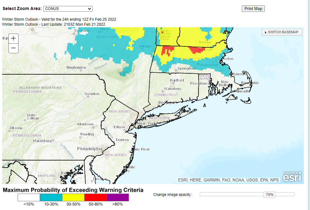
NWS a bit colder for the 25th storm snow Thurs night then snow to sleet Friday.Right on that 6 inches on the latest map.
Could be our catch up storm jimv45 and Hyde.
Could be our catch up storm jimv45 and Hyde.

docstox12- Wx Statistician Guru

- Posts : 8530
Reputation : 222
Join date : 2013-01-07
Age : 73
Location : Monroe NY
CPcantmeasuresnow, hyde345 and jimv45 like this post
heehaw453- Advanced Forecaster

- Posts : 3906
Reputation : 86
Join date : 2014-01-20
Location : Bedminster Township, PA Elevation 600' ASL
heehaw453- Advanced Forecaster

- Posts : 3906
Reputation : 86
Join date : 2014-01-20
Location : Bedminster Township, PA Elevation 600' ASL
 Re: February 25th 2022 potential snow/ice for mainly well NW of I95
In NWS Albany zone WSW criteria is 9 inches in 24 hours. 6 inches is likely to be in my backyard north of 84.

hyde345- Pro Enthusiast

- Posts : 1082
Reputation : 48
Join date : 2013-01-08
Location : Hyde Park, NY
 Re: February 25th 2022 potential snow/ice for mainly well NW of I95
hyde345 wrote:
In NWS Albany zone WSW criteria is 9 inches in 24 hours. 6 inches is likely to be in my backyard north of 84.
Ah ok that makes. Albany may meet the criteria with 7" in < 12 hours too. I'm not sure exactly what the NWS was gunning for on that and it's experimental ATTM. Either way I think you are in a good spot for this one. My point was just where the sweet spot is going to be.
heehaw453- Advanced Forecaster

- Posts : 3906
Reputation : 86
Join date : 2014-01-20
Location : Bedminster Township, PA Elevation 600' ASL
hyde345 likes this post
heehaw453- Advanced Forecaster

- Posts : 3906
Reputation : 86
Join date : 2014-01-20
Location : Bedminster Township, PA Elevation 600' ASL
 Re: February 25th 2022 potential snow/ice for mainly well NW of I95
No denying 00z's were colder and trended south with snow chances.

hyde345- Pro Enthusiast

- Posts : 1082
Reputation : 48
Join date : 2013-01-08
Location : Hyde Park, NY
 Re: February 25th 2022 potential snow/ice for mainly well NW of I95
Compared to the beginning of the month the ridging along the Canadian Rockies into Alaska (-EPO) is the big difference which means this will be a colder soln relative to the prev set up. The timing of when this moves in that coastal plain is most certainly in the game to waking up to accumulating snow Friday am before a change over as the day progresses.
_________________
"In weather and in life, there's no winning and losing; there's only winning and learning."
WINTER 2012/2013 TOTALS 43.65"WINTER 2017/2018 TOTALS 62.85" WINTER 2022/2023 TOTALS 4.9"
WINTER 2013/2014 TOTALS 64.85"WINTER 2018/2019 TOTALS 14.25" WINTER 2023/2024 TOTALS 13.1"
WINTER 2014/2015 TOTALS 71.20"WINTER 2019/2020 TOTALS 6.35"
WINTER 2015/2016 TOTALS 35.00"WINTER 2020/2021 TOTALS 37.75"
WINTER 2016/2017 TOTALS 42.25"WINTER 2021/2022 TOTALS 31.65"

sroc4- Admin

- Posts : 8354
Reputation : 302
Join date : 2013-01-07
Location : Wading River, LI
 Re: February 25th 2022 potential snow/ice for mainly well NW of I95
If this surface is correct there will be sig icing in EPA and parts of interior NJ along the I78 corridor. There will be a lot of mixing south of I84 with sleet, but that doesn't mean snow won't accumulate to 4". A lot of moisture with this system is the key to that possibility and how fast it comes in will determine accumulations. I'm hesitant on accumulations > 4" south of I84 at lower elevations regardless of what models are showing due to the track. Once the snow taints it's really hard to pile up. Beyond I84 6"+ looks feasible to me.
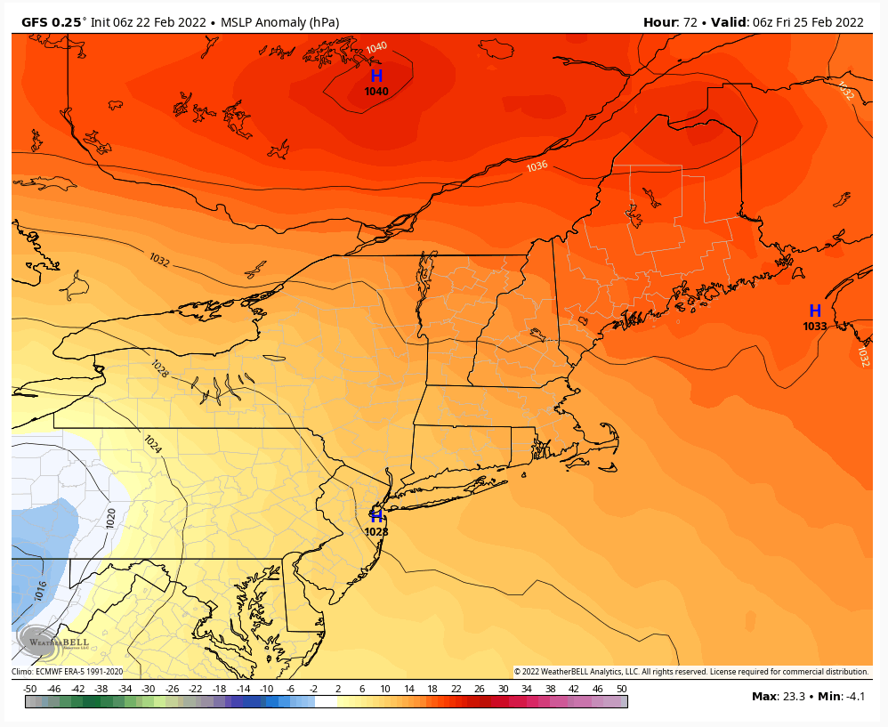
South of I84 soundings warm nose at 7500' ASL will come in hard and fast with a track like this


South of I84 soundings warm nose at 7500' ASL will come in hard and fast with a track like this

heehaw453- Advanced Forecaster

- Posts : 3906
Reputation : 86
Join date : 2014-01-20
Location : Bedminster Township, PA Elevation 600' ASL
Page 1 of 9 • 1, 2, 3, 4, 5, 6, 7, 8, 9 
Permissions in this forum:
You cannot reply to topics in this forum|
|
|

 Home
Home
