February 25th 2022 potential snow/ice for mainly well NW of I95
+30
dkodgis
mmanisca
Radz
2004blackwrx
WeatherBob
Frozen.9
1190ftalt
Taffy
essexcountypete
Sparky Sparticles
weatherwatchermom
SkiSeadooJoe
Snow88
brownie
RJB8525
SENJsnowman
Quietace
snowbunny
algae888
billg315
aiannone
sroc4
docstox12
jimv45
hyde345
amugs
frank 638
Frank_Wx
jmanley32
heehaw453
34 posters
Page 2 of 9 •  1, 2, 3, 4, 5, 6, 7, 8, 9
 Re: February 25th 2022 potential snow/ice for mainly well NW of I95
Compared to the beginning of the month the ridging along the Canadian Rockies into Alaska (-EPO) is the big difference which means this will be a colder soln relative to the prev set up. The timing of when this moves in that coastal plain is most certainly in the game to waking up to accumulating snow Friday am before a change over as the day progresses.
sroc4- Admin

- Posts : 8354
Join date : 2013-01-07
 Re: February 25th 2022 potential snow/ice for mainly well NW of I95
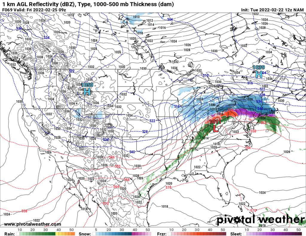
If this surface is correct there will be sig icing in EPA and parts of interior NJ along the I78 corridor. There will be a lot of mixing south of I84 with sleet, but that doesn't mean snow won't accumulate to 4". A lot of moisture with this system is the key to that possibility and how fast it comes in will determine accumulations. I'm hesitant on accumulations > 4" south of I84 at lower elevations regardless of what models are showing due to the track. Once the snow taints it's really hard to pile up. Beyond I84 6"+ looks feasible to me.
South of I84 soundings warm nose at 7500' ASL will come in hard and fast with a track like this


South of I84 soundings warm nose at 7500' ASL will come in hard and fast with a track like this

heehaw453- Advanced Forecaster

- Posts : 3906
Join date : 2014-01-20
 Re: February 25th 2022 potential snow/ice for mainly well NW of I95
sroc4 wrote:Compared to the beginning of the month the ridging along the Canadian Rockies into Alaska (-EPO) is the big difference which means this will be a colder soln relative to the prev set up. The timing of when this moves in that coastal plain is most certainly in the game to waking up to accumulating snow Friday am before a change over as the day progresses.
I think pingers will be heard quickly on this one on coastal plain until you are well into CT/RI. Snow/sleet for a few hours though before it becomes more sleet. Just hope the lower column is cold enough to support sleet rather than flipping to zr.
heehaw453- Advanced Forecaster

- Posts : 3906
Reputation : 86
Join date : 2014-01-20
Location : Bedminster Township, PA Elevation 600' ASL
sroc4 likes this post
 Re: February 25th 2022 potential snow/ice for mainly well NW of I95
What are us ny'ers just north of NYC looking at? I'm right along across from i80 so I guess it's a toss up? Whether it's snow to sleet or snow to frz? I'm about 20 miles or so south of tappenzee

jmanley32- Senior Enthusiast

- Posts : 20535
Reputation : 108
Join date : 2013-12-12
Age : 43
Location : Yonkers, NY
 Re: February 25th 2022 potential snow/ice for mainly well NW of I95
jmanley32 wrote:What are us ny'ers just north of NYC looking at? I'm right along across from i80 so I guess it's a toss up? Whether it's snow to sleet or snow to frz? I'm about 20 miles or so south of tappenzee
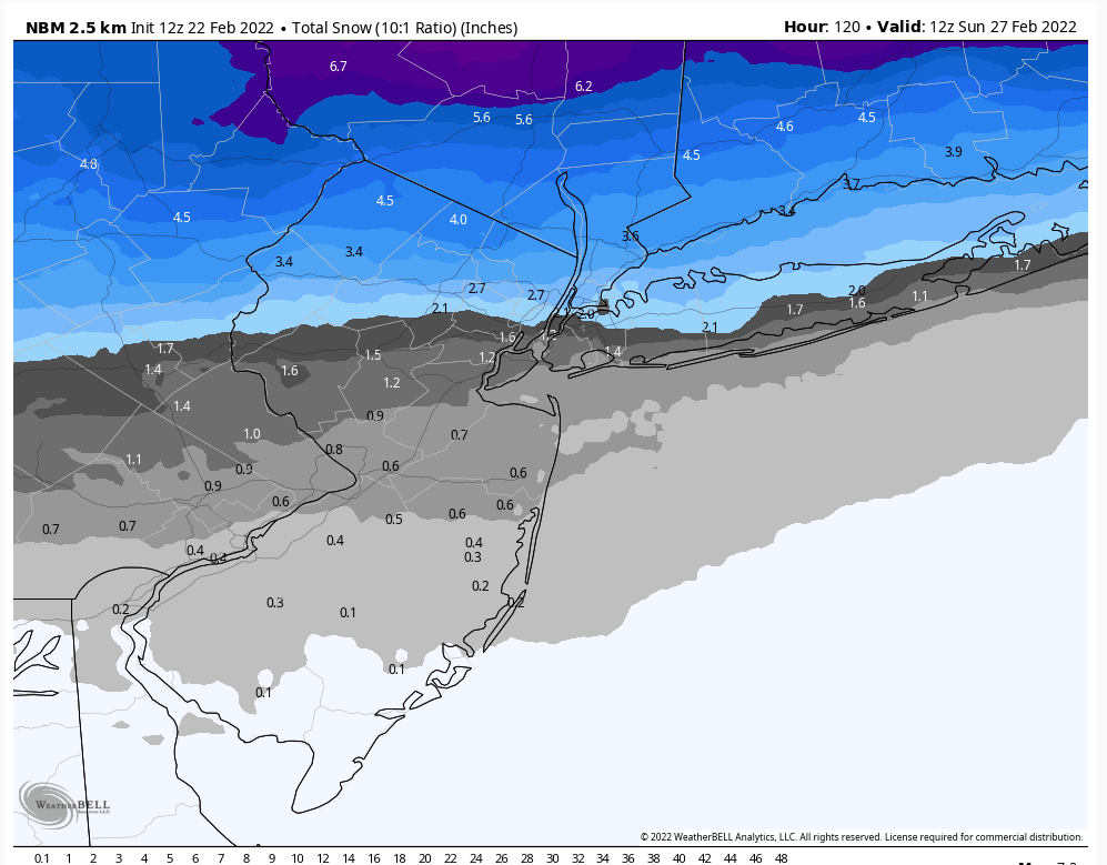
JMan I don't think there's going to be a lot of snow with one. c-2" south of rt 80 and 2-4" north of I80 to I84. The closer you get to I84 the closer to 4". Areas of elevation > 1200' could see > 4" like NEPA/NW NJ. There will be a lot of sleet with this I78 - I80. Freezing rain probably will straddle the I78 and that could be significant > .25".
heehaw453- Advanced Forecaster

- Posts : 3906
Reputation : 86
Join date : 2014-01-20
Location : Bedminster Township, PA Elevation 600' ASL
 Re: February 25th 2022 potential snow/ice for mainly well NW of I95
Okay so if i draw lines from I-80 across into NY and i84 I fall on the lower end to3wards I-80 but not sign on the line, so some snow? No ice?heehaw453 wrote:jmanley32 wrote:What are us ny'ers just north of NYC looking at? I'm right along across from i80 so I guess it's a toss up? Whether it's snow to sleet or snow to frz? I'm about 20 miles or so south of tappenzee
JMan I don't think there's going to be a lot of snow with one. c-2" south of rt 80 and 2-4" north of I80 to I84. The closer you get to I84 the closer to 4". Areas of elevation > 1200' could see > 4" like NEPA/NW NJ. There will be a lot of sleet with this I78 - I80. Freezing rain probably will straddle the I78 and that could be significant > .25".

jmanley32- Senior Enthusiast

- Posts : 20535
Reputation : 108
Join date : 2013-12-12
Age : 43
Location : Yonkers, NY
 Re: February 25th 2022 potential snow/ice for mainly well NW of I95
jmanley32 wrote:Okay so if i draw lines from I-80 across into NY and i84 I fall on the lower end to3wards I-80 but not sign on the line, so some snow? No ice?heehaw453 wrote:jmanley32 wrote:What are us ny'ers just north of NYC looking at? I'm right along across from i80 so I guess it's a toss up? Whether it's snow to sleet or snow to frz? I'm about 20 miles or so south of tappenzee
JMan I don't think there's going to be a lot of snow with one. c-2" south of rt 80 and 2-4" north of I80 to I84. The closer you get to I84 the closer to 4". Areas of elevation > 1200' could see > 4" like NEPA/NW NJ. There will be a lot of sleet with this I78 - I80. Freezing rain probably will straddle the I78 and that could be significant > .25".
I'd say 1-2" and a lot of sleet. I hope not much zr for you.
heehaw453- Advanced Forecaster

- Posts : 3906
Reputation : 86
Join date : 2014-01-20
Location : Bedminster Township, PA Elevation 600' ASL
 Re: February 25th 2022 potential snow/ice for mainly well NW of I95
well sleet is not as slippery as frz by a long shot, those GFS does show frz into the area, as you stated we need see meso scale models. though they often overdo the extent of frz, though last one ulster county did get hit pretty hard. This is Thursday into Friday right? So I work from home Fridays anyways. : ) Decided to forgo my plans for other reasons.heehaw453 wrote:jmanley32 wrote:Okay so if i draw lines from I-80 across into NY and i84 I fall on the lower end to3wards I-80 but not sign on the line, so some snow? No ice?heehaw453 wrote:jmanley32 wrote:What are us ny'ers just north of NYC looking at? I'm right along across from i80 so I guess it's a toss up? Whether it's snow to sleet or snow to frz? I'm about 20 miles or so south of tappenzee
JMan I don't think there's going to be a lot of snow with one. c-2" south of rt 80 and 2-4" north of I80 to I84. The closer you get to I84 the closer to 4". Areas of elevation > 1200' could see > 4" like NEPA/NW NJ. There will be a lot of sleet with this I78 - I80. Freezing rain probably will straddle the I78 and that could be significant > .25".
I'd say 1-2" and a lot of sleet. I hope not much zr for you.

jmanley32- Senior Enthusiast

- Posts : 20535
Reputation : 108
Join date : 2013-12-12
Age : 43
Location : Yonkers, NY
 Re: February 25th 2022 potential snow/ice for mainly well NW of I95
This can not be poo poowd in any way for N of I80 even North of l 78. This has ticked more SW over the latest 2 model runs and the warm air tongue has pushed up N towards I 84 as well. Not a good recipe and we have dodged a couple of these this year and looks like it will be our turn.
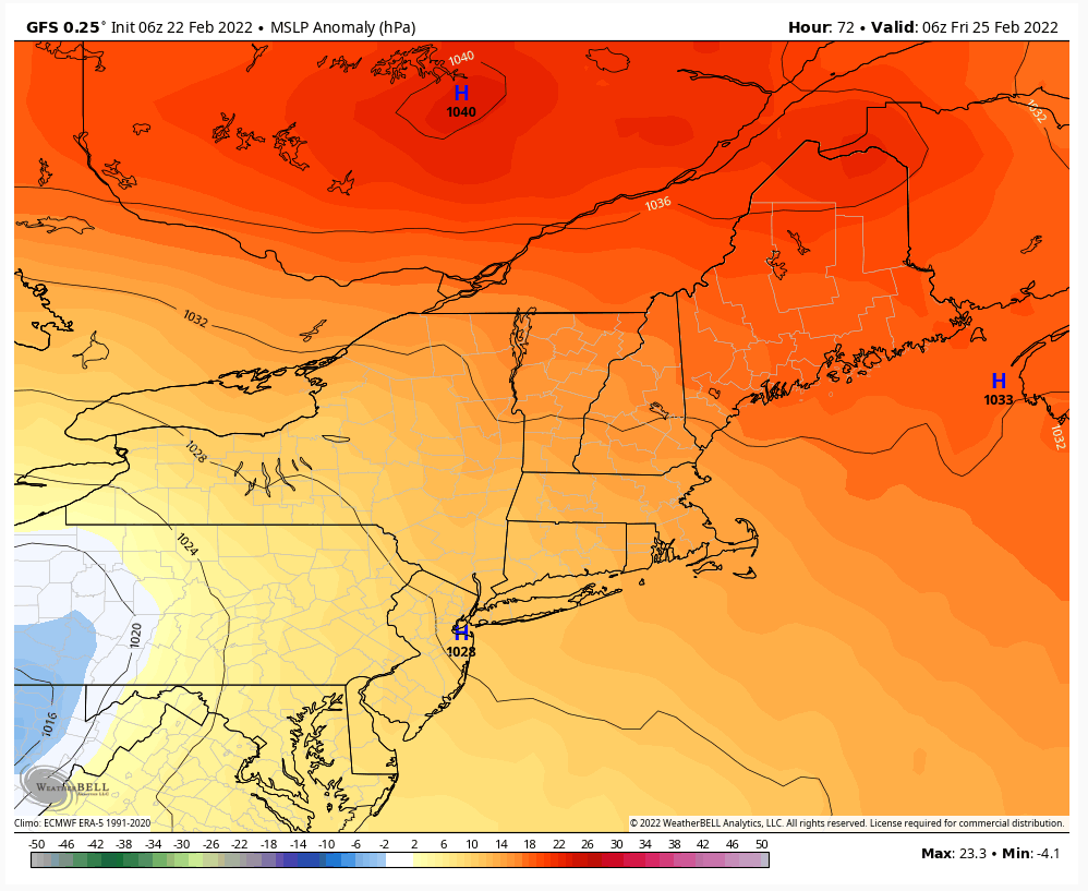
Snow to ice with rain at the end towards the coast. Time will tell but we are about 64 hours from this event. Let's see what today's runs bring. The Cold air being further S is due to the LP being further SW. And the " Euro" trends have been SW. Went from Binghamton to MD. GFS has been pretty steady being S of us.

Snow to ice with rain at the end towards the coast. Time will tell but we are about 64 hours from this event. Let's see what today's runs bring. The Cold air being further S is due to the LP being further SW. And the " Euro" trends have been SW. Went from Binghamton to MD. GFS has been pretty steady being S of us.


_________________
Mugs
AKA:King: Snow Weenie
Self Proclaimed
WINTER 2014-15 : 55.12" +.02 for 6 coatings (avg. 35")
WINTER 2015-16 Total - 29.8" (Avg 35")
WINTER 2016-17 : 39.5" so far

amugs- Advanced Forecaster - Mod

- Posts : 15095
Reputation : 213
Join date : 2013-01-07
Age : 54
Location : Hillsdale,NJ

aiannone- Senior Enthusiast - Mod

- Posts : 4815
Reputation : 92
Join date : 2013-01-07
Location : Saint James, LI (Northwest Suffolk Co.)
heehaw453- Advanced Forecaster

- Posts : 3906
Reputation : 86
Join date : 2014-01-20
Location : Bedminster Township, PA Elevation 600' ASL
 Re: February 25th 2022 potential snow/ice for mainly well NW of I95
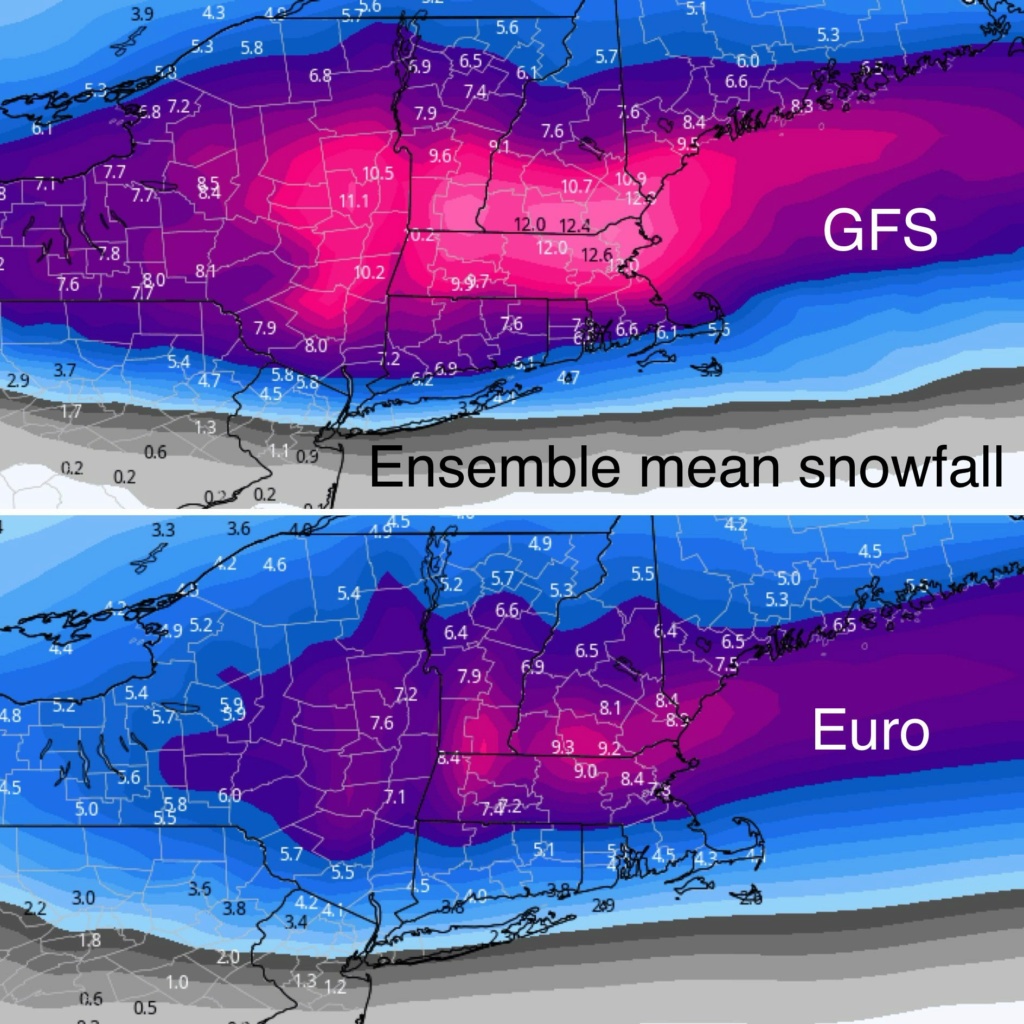
If the models are right on this Friday system, and the Euro and GFS don't seem that far apart, than this ice situation Friday morning may be nothing to sleep on. Would be right in the heart of the morning commute as well.

billg315- Advanced Forecaster - Mod

- Posts : 4483
Reputation : 185
Join date : 2015-01-24
Age : 50
Location : Flemington, NJ
heehaw453 likes this post
 Re: February 25th 2022 potential snow/ice for mainly well NW of I95
12Z GFS came in a bit colder. A slightly stronger press from the H due to the TPV pushing down a bit stronger.
My opinion on these maps is they are not going to verify w.r.t. snow. GFS has been all over the place with this storm and has not had a good handle the thermals. But of course if other models jump on board, then I wouldn't discount a consensus.
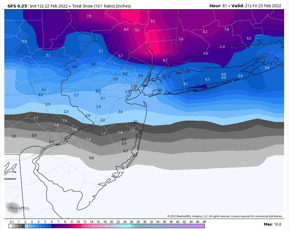
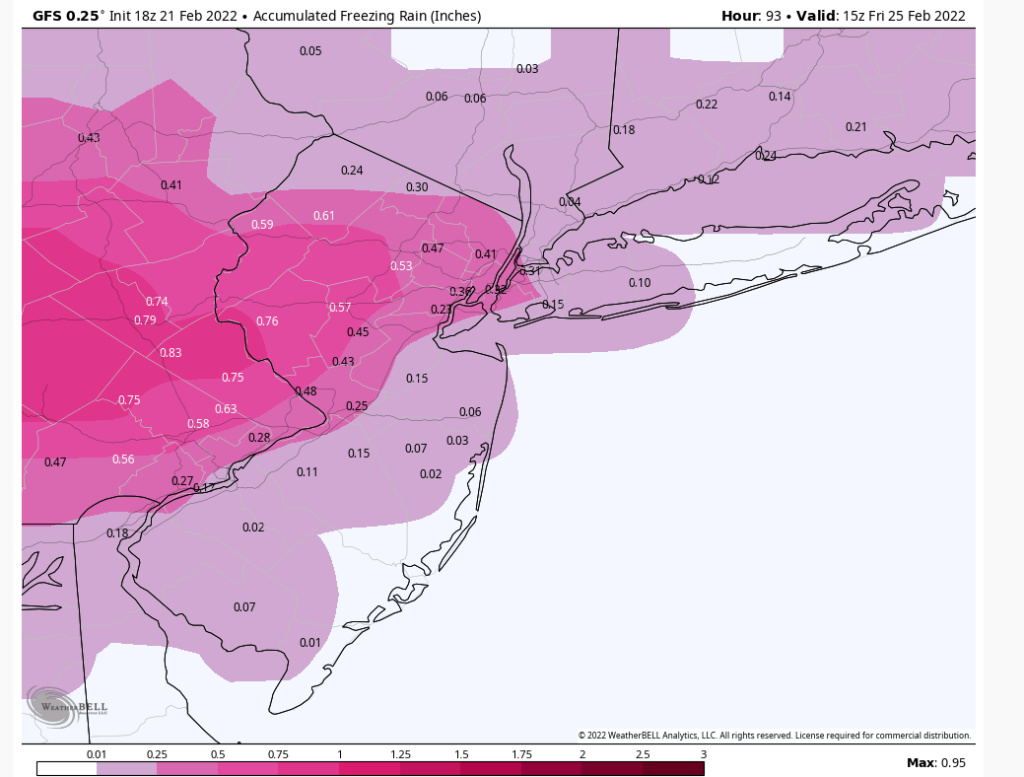
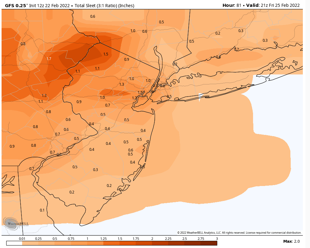
My opinion on these maps is they are not going to verify w.r.t. snow. GFS has been all over the place with this storm and has not had a good handle the thermals. But of course if other models jump on board, then I wouldn't discount a consensus.


heehaw453- Advanced Forecaster

- Posts : 3906
Reputation : 86
Join date : 2014-01-20
Location : Bedminster Township, PA Elevation 600' ASL
 Re: February 25th 2022 potential snow/ice for mainly well NW of I95
This is not where you want vort max coming through at 850mb. The damage to the mid-levels is done at this point and the warm nose finds a way to melt the crystals. It doesn't help tremendously that it's trying to reconsolidate at this point off the NJ coast. You don't want the max pushing into NY State Buffalo border like this. That needs to be about 100-150 miles south for these snow maps to make any sense to me.
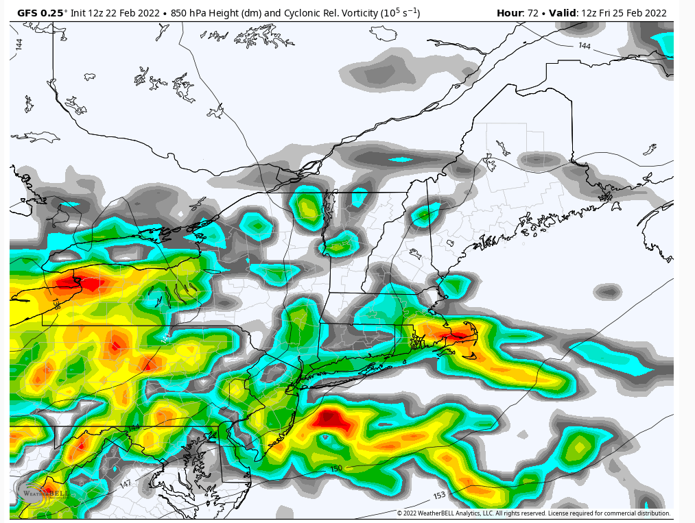

heehaw453- Advanced Forecaster

- Posts : 3906
Reputation : 86
Join date : 2014-01-20
Location : Bedminster Township, PA Elevation 600' ASL
 Re: February 25th 2022 potential snow/ice for mainly well NW of I95
The ice map was 18z, can u post the 12z?heehaw453 wrote:12Z GFS came in a bit colder. A slightly stronger press from the H due to the TPV pushing down a bit stronger.
My opinion on these maps is they are not going to verify w.r.t. snow. GFS has been all over the place with this storm and has not had a good handle the thermals. But of course if other models jump on board, then I wouldn't discount a consensus.
Last edited by jmanley32 on Tue Feb 22, 2022 11:30 am; edited 1 time in total

jmanley32- Senior Enthusiast

- Posts : 20535
Reputation : 108
Join date : 2013-12-12
Age : 43
Location : Yonkers, NY
 Re: February 25th 2022 potential snow/ice for mainly well NW of I95
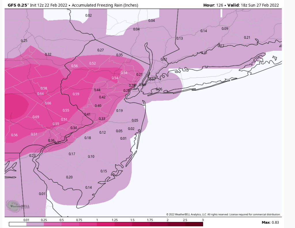
That frz on the below maps is no joke, all models have what looks like some pretty serious frz. for NNJ, NYC area and into CT.amugs wrote:This can not be poo poowd in any way for N of I80 even North of l 78. This has ticked more SW over the latest 2 model runs and the warm air tongue has pushed up N towards I 84 as well. Not a good recipe and we have dodged a couple of these this year and looks like it will be our turn.
Snow to ice with rain at the end towards the coast. Time will tell but we are about 64 hours from this event. Let's see what today's runs bring. The Cold air being further S is due to the LP being further SW. And the " Euro" trends have been SW. Went from Binghamton to MD. GFS has been pretty steady being S of us.

jmanley32- Senior Enthusiast

- Posts : 20535
Reputation : 108
Join date : 2013-12-12
Age : 43
Location : Yonkers, NY
 Re: February 25th 2022 potential snow/ice for mainly well NW of I95
jmanley32 wrote:The ice map was 18z, can u post the 12z?heehaw453 wrote:12Z GFS came in a bit colder. A slightly stronger press from the H due to the TPV pushing down a bit stronger.
My opinion on these maps is they are not going to verify w.r.t. snow. GFS has been all over the place with this storm and has not had a good handle the thermals. But of course if other models jump on board, then I wouldn't discount a consensus.
Oh yeah. you are right. IMO >= .25" ice accretion is on the table.
heehaw453- Advanced Forecaster

- Posts : 3906
Reputation : 86
Join date : 2014-01-20
Location : Bedminster Township, PA Elevation 600' ASL
heehaw453- Advanced Forecaster

- Posts : 3906
Reputation : 86
Join date : 2014-01-20
Location : Bedminster Township, PA Elevation 600' ASL
 Re: February 25th 2022 potential snow/ice for mainly well NW of I95
I think we will find the gfs is correct for reasons Ill explain when I have some time
_________________
"In weather and in life, there's no winning and losing; there's only winning and learning."
WINTER 2012/2013 TOTALS 43.65"WINTER 2017/2018 TOTALS 62.85" WINTER 2022/2023 TOTALS 4.9"
WINTER 2013/2014 TOTALS 64.85"WINTER 2018/2019 TOTALS 14.25" WINTER 2023/2024 TOTALS 13.1"
WINTER 2014/2015 TOTALS 71.20"WINTER 2019/2020 TOTALS 6.35"
WINTER 2015/2016 TOTALS 35.00"WINTER 2020/2021 TOTALS 37.75"
WINTER 2016/2017 TOTALS 42.25"WINTER 2021/2022 TOTALS 31.65"

sroc4- Admin

- Posts : 8354
Reputation : 302
Join date : 2013-01-07
Location : Wading River, LI
heehaw453 likes this post
 Re: February 25th 2022 potential snow/ice for mainly well NW of I95
It begins with a great antecedant air mass and a westerly flow to the 700mb level as the moisture comes in.


_________________
"In weather and in life, there's no winning and losing; there's only winning and learning."
WINTER 2012/2013 TOTALS 43.65"WINTER 2017/2018 TOTALS 62.85" WINTER 2022/2023 TOTALS 4.9"
WINTER 2013/2014 TOTALS 64.85"WINTER 2018/2019 TOTALS 14.25" WINTER 2023/2024 TOTALS 13.1"
WINTER 2014/2015 TOTALS 71.20"WINTER 2019/2020 TOTALS 6.35"
WINTER 2015/2016 TOTALS 35.00"WINTER 2020/2021 TOTALS 37.75"
WINTER 2016/2017 TOTALS 42.25"WINTER 2021/2022 TOTALS 31.65"

sroc4- Admin

- Posts : 8354
Reputation : 302
Join date : 2013-01-07
Location : Wading River, LI
 Re: February 25th 2022 potential snow/ice for mainly well NW of I95
sroc4 wrote:It begins with a great antecedant air mass and a westerly flow to the 700mb level as the moisture comes in.
_________________
"In weather and in life, there's no winning and losing; there's only winning and learning."
WINTER 2012/2013 TOTALS 43.65"WINTER 2017/2018 TOTALS 62.85" WINTER 2022/2023 TOTALS 4.9"
WINTER 2013/2014 TOTALS 64.85"WINTER 2018/2019 TOTALS 14.25" WINTER 2023/2024 TOTALS 13.1"
WINTER 2014/2015 TOTALS 71.20"WINTER 2019/2020 TOTALS 6.35"
WINTER 2015/2016 TOTALS 35.00"WINTER 2020/2021 TOTALS 37.75"
WINTER 2016/2017 TOTALS 42.25"WINTER 2021/2022 TOTALS 31.65"

sroc4- Admin

- Posts : 8354
Reputation : 302
Join date : 2013-01-07
Location : Wading River, LI
 Re: February 25th 2022 potential snow/ice for mainly well NW of I95
sroc4 wrote:sroc4 wrote:It begins with a great antecedant air mass and a westerly flow to the 700mb level as the moisture comes in.
I can see that line of thinking but IMO you will get a warm nose between 850-700mb as the max vorticity of the 850mb is really far north. It will be high enough in the column to render sleet and not zr especially north of I78. At least that is my thinking. I would be fully on board if the mid-levels were tracking the way GFS showed several days ago...
heehaw453- Advanced Forecaster

- Posts : 3906
Reputation : 86
Join date : 2014-01-20
Location : Bedminster Township, PA Elevation 600' ASL
 Re: February 25th 2022 potential snow/ice for mainly well NW of I95
Well . . . 12Z Euro is an even bigger front-end dump of snow. Generally 4-6" north of I-195 in Central NJ. And then prolonged ice to boot.

billg315- Advanced Forecaster - Mod

- Posts : 4483
Reputation : 185
Join date : 2015-01-24
Age : 50
Location : Flemington, NJ
 Re: February 25th 2022 potential snow/ice for mainly well NW of I95
heehaw453 wrote:sroc4 wrote:sroc4 wrote:It begins with a great antecedant air mass and a westerly flow to the 700mb level as the moisture comes in.
I can see that line of thinking but IMO you will get a warm nose between 850-700mb as the max vorticity of the 850mb is really far north. It will be high enough in the column to render sleet and not zr especially north of I78. At least that is my thinking. I would be fully on board if the mid-levels were tracking the way GFS showed several days ago...
As I try to dispute your theory Euro comes in colder.
heehaw453- Advanced Forecaster

- Posts : 3906
Reputation : 86
Join date : 2014-01-20
Location : Bedminster Township, PA Elevation 600' ASL
sroc4 likes this post
 Re: February 25th 2022 potential snow/ice for mainly well NW of I95
_________________
-Alex Iannone-

aiannone- Senior Enthusiast - Mod

- Posts : 4815
Reputation : 92
Join date : 2013-01-07
Location : Saint James, LI (Northwest Suffolk Co.)
 Re: February 25th 2022 potential snow/ice for mainly well NW of I95
Heehaw we never close off at 850 or 700 and 850's have multi focal vort max's. The front end thump you have 700 screaming out of the west and 850 out of the SW and not S, SE or E like when you get that close 850 low. Larry Cosgrove taught me a long time ago that when you see 700mb out of the west with an over runing event without any of the midl evels closing off it screams of correcting colder and snowier. It would not surprise me if the mid level trends cont we get colder and snowier down to the coast.
_________________
"In weather and in life, there's no winning and losing; there's only winning and learning."
WINTER 2012/2013 TOTALS 43.65"WINTER 2017/2018 TOTALS 62.85" WINTER 2022/2023 TOTALS 4.9"
WINTER 2013/2014 TOTALS 64.85"WINTER 2018/2019 TOTALS 14.25" WINTER 2023/2024 TOTALS 13.1"
WINTER 2014/2015 TOTALS 71.20"WINTER 2019/2020 TOTALS 6.35"
WINTER 2015/2016 TOTALS 35.00"WINTER 2020/2021 TOTALS 37.75"
WINTER 2016/2017 TOTALS 42.25"WINTER 2021/2022 TOTALS 31.65"

sroc4- Admin

- Posts : 8354
Reputation : 302
Join date : 2013-01-07
Location : Wading River, LI
amugs, hyde345, SoulSingMG and heehaw453 like this post
 Re: February 25th 2022 potential snow/ice for mainly well NW of I95
Def says something that both the GFS and the Euro have lurched in the colder direction at the same time. What that is I don't know. But something. lol.

billg315- Advanced Forecaster - Mod

- Posts : 4483
Reputation : 185
Join date : 2015-01-24
Age : 50
Location : Flemington, NJ
heehaw453 likes this post
Page 2 of 9 •  1, 2, 3, 4, 5, 6, 7, 8, 9
Permissions in this forum:
You cannot reply to topics in this forum|
|
|

 Home
Home