February 25th 2022 potential snow/ice for mainly well NW of I95
+30
dkodgis
mmanisca
Radz
2004blackwrx
WeatherBob
Frozen.9
1190ftalt
Taffy
essexcountypete
Sparky Sparticles
weatherwatchermom
SkiSeadooJoe
Snow88
brownie
RJB8525
SENJsnowman
Quietace
snowbunny
algae888
billg315
aiannone
sroc4
docstox12
jimv45
hyde345
amugs
frank 638
Frank_Wx
jmanley32
heehaw453
34 posters
Page 4 of 9 •  1, 2, 3, 4, 5, 6, 7, 8, 9
 Re: February 25th 2022 potential snow/ice for mainly well NW of I95
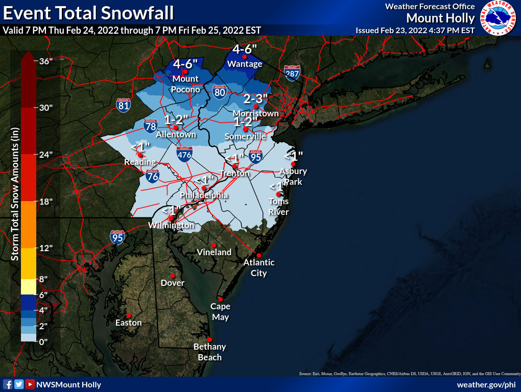
NWS has me at 6-12 not much mixing expected up here! I can see some sleet getting up to 84 but not expecting any FRZ.
jimv45- Senior Enthusiast

- Posts : 1168
Join date : 2013-09-20
heehaw453 likes this post
 Re: February 25th 2022 potential snow/ice for mainly well NW of I95
12Z NAM is off its rocker still IMO w.r.t. to snowfall. I wouldn't buy into its snow maps for those NW. It's bad synoptically, but IMO not that bad. Probably next few runs it corrects...
heehaw453- Advanced Forecaster

- Posts : 3906
Join date : 2014-01-20
heehaw453- Advanced Forecaster

- Posts : 3906
Reputation : 86
Join date : 2014-01-20
Location : Bedminster Township, PA Elevation 600' ASL
 Re: February 25th 2022 potential snow/ice for mainly well NW of I95
heehaw what is wrt? LOL probably something I know but i read your posts and wonder what that means.
Edit: is it with regards to?
Edit: is it with regards to?

jmanley32- Senior Enthusiast

- Posts : 20535
Reputation : 108
Join date : 2013-12-12
Age : 43
Location : Yonkers, NY
weatherwatchermom likes this post
 Re: February 25th 2022 potential snow/ice for mainly well NW of I95
When does the snow start for NYC area on east Thursday night?

jmanley32- Senior Enthusiast

- Posts : 20535
Reputation : 108
Join date : 2013-12-12
Age : 43
Location : Yonkers, NY
 Re: February 25th 2022 potential snow/ice for mainly well NW of I95
jmanley32 wrote:heehaw what is wrt? LOL probably something I know but i read your posts and wonder what that means.
Edit: is it with regards to?
With Regards To
I think
_________________
"In weather and in life, there's no winning and losing; there's only winning and learning."
WINTER 2012/2013 TOTALS 43.65"WINTER 2017/2018 TOTALS 62.85" WINTER 2022/2023 TOTALS 4.9"
WINTER 2013/2014 TOTALS 64.85"WINTER 2018/2019 TOTALS 14.25" WINTER 2023/2024 TOTALS 13.1"
WINTER 2014/2015 TOTALS 71.20"WINTER 2019/2020 TOTALS 6.35"
WINTER 2015/2016 TOTALS 35.00"WINTER 2020/2021 TOTALS 37.75"
WINTER 2016/2017 TOTALS 42.25"WINTER 2021/2022 TOTALS 31.65"

sroc4- Admin

- Posts : 8354
Reputation : 302
Join date : 2013-01-07
Location : Wading River, LI
heehaw453 likes this post
 Re: February 25th 2022 potential snow/ice for mainly well NW of I95
Lets remember with this storm we are coming off very mild conditions near coast will have problems with getting anything significant frozen, I expect north of 287 4 plus of snow with sleet and some FRZ! Heehaw is correct i think the jackpot will be near Albany.
jimv45- Senior Enthusiast

- Posts : 1168
Reputation : 36
Join date : 2013-09-20
Location : Hopewell jct.
 Re: February 25th 2022 potential snow/ice for mainly well NW of I95
I could see a burst of snow for NS of LI on this. Just far enough north to evade the WAA for just long enough for an initial thump. Surface will be marginal based on soundings, but it may thump nonetheless. SS of LI I don't think so for much...
heehaw453- Advanced Forecaster

- Posts : 3906
Reputation : 86
Join date : 2014-01-20
Location : Bedminster Township, PA Elevation 600' ASL
 Re: February 25th 2022 potential snow/ice for mainly well NW of I95
sroc4 wrote:jmanley32 wrote:heehaw what is wrt? LOL probably something I know but i read your posts and wonder what that means.
Edit: is it with regards to?
With Regards To
I think
My vote is actually for ‘with respect to’. But I will accept ‘with regards to’ if that is the consensus.
SENJsnowman- Senior Enthusiast

- Posts : 1189
Reputation : 61
Join date : 2017-01-06
Age : 51
Location : Bayville, NJ
heehaw453 likes this post
 Re: February 25th 2022 potential snow/ice for mainly well NW of I95
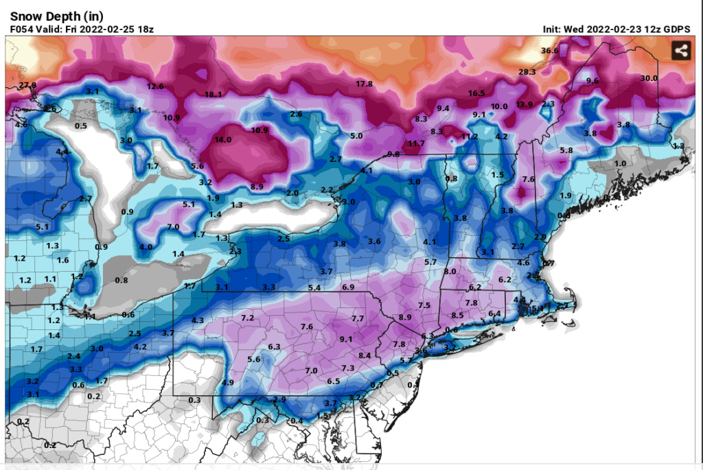
Does anyone know what the snow depth on Pivotal or TT is supposed to represent? Counting sleet/zr as 10:1 snow?, cannot really think of anything that makes this look like anything but utter nonsense for EPA.

Yeah. It's basically terrible to use if there is a warm nose like this storm as it's counting the precip that falls as snow based on the surface temps is what I get out of this. Where it seems to add value is compaction rates after snow has fallen. Assuming the snow fell LoL.
Model snow depth
Finally, we would like to address the use of model snow depth. We plot snow depth for many models; additionally, for some, we plot an estimate for snowfall that leverages "accumulated positive snow depth change." The name “snow depth” may seem to suggest that it represents a highly accurate account of snow that accumulated on the ground during the model run, with non-snow precipitation removed and highly accurate SLRs applied. Unfortunately, this usually is not the case, leading to misconceptions in the weather community. The details of how snow depth is computed vary from model to model, even within the NCEP suite. Below are links to technical descriptions of snow cover, density, and depth for three different classes of NCEP models:
NCEP GFS: https://sites.google.com/a/ucar.edu/model-encyclo-determ/deterministic/gfs/snow-initial-condition-and-forecast
NCEP NAM: https://sites.google.com/a/ucar.edu/model-encyclo-determ/deterministic/namb/snow-initial-condition-and-forecast
NCEP RAP/HRRR: https://sites.google.com/a/ucar.edu/model-encyclo-determ/deterministic/rap/snow-initial-condition-and-forecast
Environment Canada GDPS/RDPS: see Eq. 24 of Bélair et al. 2003
Of note: modeled precipitation is typically counted as all snow on the condition that more than half of what is falling is frozen, even if some or all is actually sleet. Furthermore, the SLR applied to this frozen precipitation is based solely on the near-ground air temperature for the NAM and RAP/HRRR; the situation is similar for the GDPS/RDPS, except that near-ground wind speed is also considered. In essence, these SLRs are just simpler and less accurate versions of what Crapola does, considering only one temperature level instead of many. Thus, we cannot assume that snow depth has accrued in the model using an accurate SLR, nor that it only includes snow. [Note that an especially common error when using near-ground temperature to infer SLR is when a “warm nose” is present above very cold air at the surface, in which case SLR can be greatly overestimated; Crapola addresses this scenario more realistically].
On the other hand, the snow depth variable does attempt to account for melting, compacting, and sublimation on a representative ground surface, and is even able to take advantage of minute-to-minute changes in the soil model state while doing so. So, in that regard, it can be more useful for estimating the ground accumulation at the end of a snowstorm than our 10:1 and Crapola snowfall products. Still, this benefit is offset by the substantial pitfalls of using very imprecise SLRs and typically treating sleet as snow.
Conceptually, users should realize the snow depth variable is just a byproduct of internal model considerations around surface fluxes; this is a domain of physics where the precise snow depth may not be quite as crucial as the total mass of frozen precipitation covering the ground. As such, using model snow depth to forecast snowfall is subject to caveats and errors that are of similar magnitude to 10:1 or Crapola, and it may perform even worse in some situations!
Last edited by heehaw453 on Wed Feb 23, 2022 5:10 pm; edited 1 time in total
heehaw453- Advanced Forecaster

- Posts : 3906
Reputation : 86
Join date : 2014-01-20
Location : Bedminster Township, PA Elevation 600' ASL
 Re: February 25th 2022 potential snow/ice for mainly well NW of I95
SENJsnowman wrote:sroc4 wrote:jmanley32 wrote:heehaw what is wrt? LOL probably something I know but i read your posts and wonder what that means.
Edit: is it with regards to?
With Regards To
I think
My vote is actually for ‘with respect to’. But I will accept ‘with regards to’ if that is the consensus.
LOL I believe this image is appropriate

_________________
"In weather and in life, there's no winning and losing; there's only winning and learning."
WINTER 2012/2013 TOTALS 43.65"WINTER 2017/2018 TOTALS 62.85" WINTER 2022/2023 TOTALS 4.9"
WINTER 2013/2014 TOTALS 64.85"WINTER 2018/2019 TOTALS 14.25" WINTER 2023/2024 TOTALS 13.1"
WINTER 2014/2015 TOTALS 71.20"WINTER 2019/2020 TOTALS 6.35"
WINTER 2015/2016 TOTALS 35.00"WINTER 2020/2021 TOTALS 37.75"
WINTER 2016/2017 TOTALS 42.25"WINTER 2021/2022 TOTALS 31.65"

sroc4- Admin

- Posts : 8354
Reputation : 302
Join date : 2013-01-07
Location : Wading River, LI
SENJsnowman likes this post
 Re: February 25th 2022 potential snow/ice for mainly well NW of I95
Yeah, nobody is talking about me getting snow anymore, so I am feeling a little uppity over here...I'll mind my manners a little better (But I still vote for 'with respect to'  ).
).
SENJsnowman- Senior Enthusiast

- Posts : 1189
Reputation : 61
Join date : 2017-01-06
Age : 51
Location : Bayville, NJ
kalleg likes this post
 Re: February 25th 2022 potential snow/ice for mainly well NW of I95
Sometimes a storm that doesn't seem to capture the full imagination of folks (in the sense that everyone is talking about it like some of our major storms) has outsized impacts. This may be one of those. I sense that Friday morning will be a lot more chaotic (wrt travel issues, school closings, other disruptions) than what some people may be expecting atm.
1. wrt: with regard to
2. atm: at the moment
1. wrt: with regard to
2. atm: at the moment

billg315- Advanced Forecaster - Mod

- Posts : 4483
Reputation : 185
Join date : 2015-01-24
Age : 50
Location : Flemington, NJ
brownie and SENJsnowman like this post
heehaw453- Advanced Forecaster

- Posts : 3906
Reputation : 86
Join date : 2014-01-20
Location : Bedminster Township, PA Elevation 600' ASL
 Re: February 25th 2022 potential snow/ice for mainly well NW of I95
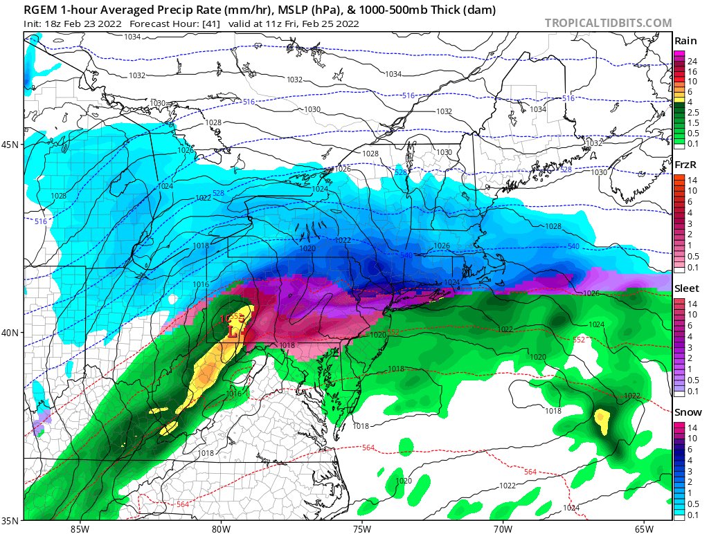
Euro and GFS are more aggressive on the southern extent of the accumulating snows than the NAM, but all three seem to agree on significant ice issues. That is quite concerning. The projected ice totals on all three models are well above what you need for a serious impact.

billg315- Advanced Forecaster - Mod

- Posts : 4483
Reputation : 185
Join date : 2015-01-24
Age : 50
Location : Flemington, NJ
mmanisca likes this post
heehaw453- Advanced Forecaster

- Posts : 3906
Reputation : 86
Join date : 2014-01-20
Location : Bedminster Township, PA Elevation 600' ASL
 Re: February 25th 2022 potential snow/ice for mainly well NW of I95
billg315 wrote:Euro and GFS are more aggressive on the southern extent of the accumulating snows than the NAM, but all three seem to agree on significant ice issues. That is quite concerning. The projected ice totals on all three models are well above what you need for a serious impact.
The ice impact has been stressed in a lot of posts and hope no one on this board is underplaying that. If you are straddling (+/- 20 miles) I78 EPA well into NJ, then you should be planning for sig impacts.
heehaw453- Advanced Forecaster

- Posts : 3906
Reputation : 86
Join date : 2014-01-20
Location : Bedminster Township, PA Elevation 600' ASL
 Re: February 25th 2022 potential snow/ice for mainly well NW of I95
what about over here? I know one run showed a half inch or so in and around NYC area then it slims off and non into LI or CT.heehaw453 wrote:billg315 wrote:Euro and GFS are more aggressive on the southern extent of the accumulating snows than the NAM, but all three seem to agree on significant ice issues. That is quite concerning. The projected ice totals on all three models are well above what you need for a serious impact.
The ice impact has been stressed in a lot of posts and hope no one on this board is underplaying that. If you are straddling (+/- 20 miles) I78 EPA well into NJ, then you should be planning for sig impacts.
Last edited by jmanley32 on Wed Feb 23, 2022 3:12 pm; edited 1 time in total

jmanley32- Senior Enthusiast

- Posts : 20535
Reputation : 108
Join date : 2013-12-12
Age : 43
Location : Yonkers, NY
 Re: February 25th 2022 potential snow/ice for mainly well NW of I95
jmanley32 wrote:what about over here?heehaw453 wrote:billg315 wrote:Euro and GFS are more aggressive on the southern extent of the accumulating snows than the NAM, but all three seem to agree on significant ice issues. That is quite concerning. The projected ice totals on all three models are well above what you need for a serious impact.
The ice impact has been stressed in a lot of posts and hope no one on this board is underplaying that. If you are straddling (+/- 20 miles) I78 EPA well into NJ, then you should be planning for sig impacts.
Hard to know JMAN, but Rt 80 and above IMO would be more ip than zr.
heehaw453- Advanced Forecaster

- Posts : 3906
Reputation : 86
Join date : 2014-01-20
Location : Bedminster Township, PA Elevation 600' ASL
 Re: February 25th 2022 potential snow/ice for mainly well NW of I95
Yeah I-80 if u draw a line is slightly below me so it may be pingers as you say. but probably a nowcast?heehaw453 wrote:jmanley32 wrote:what about over here?heehaw453 wrote:billg315 wrote:Euro and GFS are more aggressive on the southern extent of the accumulating snows than the NAM, but all three seem to agree on significant ice issues. That is quite concerning. The projected ice totals on all three models are well above what you need for a serious impact.
The ice impact has been stressed in a lot of posts and hope no one on this board is underplaying that. If you are straddling (+/- 20 miles) I78 EPA well into NJ, then you should be planning for sig impacts.
Hard to know JMAN, but Rt 80 and above IMO would be more ip than zr.

jmanley32- Senior Enthusiast

- Posts : 20535
Reputation : 108
Join date : 2013-12-12
Age : 43
Location : Yonkers, NY
 Re: February 25th 2022 potential snow/ice for mainly well NW of I95
The HRRR has done pretty well with some of the storms this year. On it's last 48-hour run It is closer to the GFS and Euro in terms of some decent front-end snow north of I-80, although not quite as aggressive on the icing issue -- albeit while still showing significant icing in North Jersey. The NAM seems to be the outlier in terms of a warmer solution (although still showing some icing issues).

billg315- Advanced Forecaster - Mod

- Posts : 4483
Reputation : 185
Join date : 2015-01-24
Age : 50
Location : Flemington, NJ

RJB8525- Senior Enthusiast

- Posts : 1994
Reputation : 28
Join date : 2013-02-06
Age : 38
Location : Hackettstown, NJ
 Re: February 25th 2022 potential snow/ice for mainly well NW of I95
Models definitely showing LHV 6"+ consistently now. Have to watch that trend...
heehaw453- Advanced Forecaster

- Posts : 3906
Reputation : 86
Join date : 2014-01-20
Location : Bedminster Township, PA Elevation 600' ASL
 Re: February 25th 2022 potential snow/ice for mainly well NW of I95
_________________
Mugs
AKA:King: Snow Weenie
Self Proclaimed
WINTER 2014-15 : 55.12" +.02 for 6 coatings (avg. 35")
WINTER 2015-16 Total - 29.8" (Avg 35")
WINTER 2016-17 : 39.5" so far

amugs- Advanced Forecaster - Mod

- Posts : 15095
Reputation : 213
Join date : 2013-01-07
Age : 54
Location : Hillsdale,NJ
 Re: February 25th 2022 potential snow/ice for mainly well NW of I95
NWS has a winter storm watch for Morris County, up to 0.33 inch of ice. 

brownie- Posts : 393
Reputation : 17
Join date : 2013-11-10
Location : Parsippany, NJ
RJB8525 and SENJsnowman like this post
 Re: February 25th 2022 potential snow/ice for mainly well NW of I95
Euro is starting to catch on. Let’s see if it’s a blip or do we see others follow suite.
_________________
"In weather and in life, there's no winning and losing; there's only winning and learning."
WINTER 2012/2013 TOTALS 43.65"WINTER 2017/2018 TOTALS 62.85" WINTER 2022/2023 TOTALS 4.9"
WINTER 2013/2014 TOTALS 64.85"WINTER 2018/2019 TOTALS 14.25" WINTER 2023/2024 TOTALS 13.1"
WINTER 2014/2015 TOTALS 71.20"WINTER 2019/2020 TOTALS 6.35"
WINTER 2015/2016 TOTALS 35.00"WINTER 2020/2021 TOTALS 37.75"
WINTER 2016/2017 TOTALS 42.25"WINTER 2021/2022 TOTALS 31.65"

sroc4- Admin

- Posts : 8354
Reputation : 302
Join date : 2013-01-07
Location : Wading River, LI
 Re: February 25th 2022 potential snow/ice for mainly well NW of I95
Euro is colder this run

Snow88- Senior Enthusiast

- Posts : 2193
Reputation : 4
Join date : 2013-01-09
Age : 35
Location : Brooklyn, NY
Page 4 of 9 •  1, 2, 3, 4, 5, 6, 7, 8, 9
Permissions in this forum:
You cannot reply to topics in this forum|
|
|

 Home
Home


