February 25th 2022 potential snow/ice for mainly well NW of I95
+30
dkodgis
mmanisca
Radz
2004blackwrx
WeatherBob
Frozen.9
1190ftalt
Taffy
essexcountypete
Sparky Sparticles
weatherwatchermom
SkiSeadooJoe
Snow88
brownie
RJB8525
SENJsnowman
Quietace
snowbunny
algae888
billg315
aiannone
sroc4
docstox12
jimv45
hyde345
amugs
frank 638
Frank_Wx
jmanley32
heehaw453
34 posters
Page 3 of 9 •  1, 2, 3, 4, 5, 6, 7, 8, 9
 Re: February 25th 2022 potential snow/ice for mainly well NW of I95
Heehaw we never close off at 850 or 700 and 850's have multi focal vort max's. The front end thump you have 700 screaming out of the west and 850 out of the SW and not S, SE or E like when you get that close 850 low. Larry Cosgrove taught me a long time ago that when you see 700mb out of the west with an over runing event without any of the midl evels closing off it screams of correcting colder and snowier. It would not surprise me if the mid level trends cont we get colder and snowier down to the coast.
sroc4- Admin

- Posts : 8354
Join date : 2013-01-07
amugs, hyde345, SoulSingMG and heehaw453 like this post
 Re: February 25th 2022 potential snow/ice for mainly well NW of I95
Def says something that both the GFS and the Euro have lurched in the colder direction at the same time. What that is I don't know. But something. lol.
billg315- Advanced Forecaster - Mod

- Posts : 4483
Join date : 2015-01-24
heehaw453 likes this post
 Re: February 25th 2022 potential snow/ice for mainly well NW of I95
BTW weather bell now has soundings for Euro GFS etc. Both 12z dont have the warm nose come in for at least 6 hrs once the precip moves in
_________________
"In weather and in life, there's no winning and losing; there's only winning and learning."
WINTER 2012/2013 TOTALS 43.65"WINTER 2017/2018 TOTALS 62.85" WINTER 2022/2023 TOTALS 4.9"
WINTER 2013/2014 TOTALS 64.85"WINTER 2018/2019 TOTALS 14.25" WINTER 2023/2024 TOTALS 13.1"
WINTER 2014/2015 TOTALS 71.20"WINTER 2019/2020 TOTALS 6.35"
WINTER 2015/2016 TOTALS 35.00"WINTER 2020/2021 TOTALS 37.75"
WINTER 2016/2017 TOTALS 42.25"WINTER 2021/2022 TOTALS 31.65"

sroc4- Admin

- Posts : 8354
Reputation : 302
Join date : 2013-01-07
Location : Wading River, LI
mmanisca and heehaw453 like this post
 Re: February 25th 2022 potential snow/ice for mainly well NW of I95
12z's are colder again. CMC is too warm.

hyde345- Pro Enthusiast

- Posts : 1082
Reputation : 48
Join date : 2013-01-08
Location : Hyde Park, NY
 Re: February 25th 2022 potential snow/ice for mainly well NW of I95
The Euro colder solution is highly dependent on the TPV press against the SE ridge. This TPV is acting similar to an -NAO block and is the only reason this has a chance. The more it presses the less latitude the mid-levels storms will get as well pinning the H deeper and longer in an ideal spot. It's exactly what the GFS was showing several days ago and then lost that idea. Is this just BS well were getting deep into the process now, so there's that. Nonetheless a slightly less press by the TPV and this goes northward again. Blocks many times can surprise on the good side...
It's not much but look at northern ME and note the press. Yeah it's that subtle.
12Z
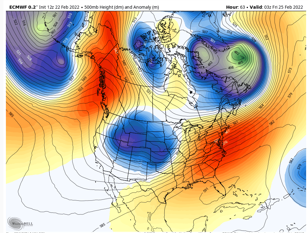
06Z
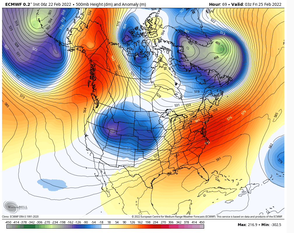
It's not much but look at northern ME and note the press. Yeah it's that subtle.
12Z

06Z

heehaw453- Advanced Forecaster

- Posts : 3906
Reputation : 86
Join date : 2014-01-20
Location : Bedminster Township, PA Elevation 600' ASL
 Re: February 25th 2022 potential snow/ice for mainly well NW of I95
heehaw453 wrote:The Euro colder solution is highly dependent on the TPV press against the SE ridge. This TPV is acting similar to an -NAO block and is the only reason this has a chance. The more it presses the less latitude the mid-levels storms will get as well pinning the H deeper and longer in an ideal spot. It's exactly what the GFS was showing several days ago and then lost that idea. Is this just BS well were getting deep into the process now, so there's that. Nonetheless a slightly less press by the TPV and this goes northward again. Blocks many times can surprise on the good side...
It's not much but look at northern ME and note the press. Yeah it's that subtle.
12Z
06Z
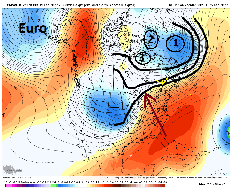
totally. Here was the image I posted a few days ago and what the euro looked like vs what it loks like today. TPV Much more organized than prev.
_________________
"In weather and in life, there's no winning and losing; there's only winning and learning."
WINTER 2012/2013 TOTALS 43.65"WINTER 2017/2018 TOTALS 62.85" WINTER 2022/2023 TOTALS 4.9"
WINTER 2013/2014 TOTALS 64.85"WINTER 2018/2019 TOTALS 14.25" WINTER 2023/2024 TOTALS 13.1"
WINTER 2014/2015 TOTALS 71.20"WINTER 2019/2020 TOTALS 6.35"
WINTER 2015/2016 TOTALS 35.00"WINTER 2020/2021 TOTALS 37.75"
WINTER 2016/2017 TOTALS 42.25"WINTER 2021/2022 TOTALS 31.65"

sroc4- Admin

- Posts : 8354
Reputation : 302
Join date : 2013-01-07
Location : Wading River, LI
heehaw453 likes this post
 Re: February 25th 2022 potential snow/ice for mainly well NW of I95
sroc4 wrote:Heehaw we never close off at 850 or 700 and 850's have multi focal vort max's. The front end thump you have 700 screaming out of the west and 850 out of the SW and not S, SE or E like when you get that close 850 low. Larry Cosgrove taught me a long time ago that when you see 700mb out of the west with an over runing event without any of the midl evels closing off it screams of correcting colder and snowier. It would not surprise me if the mid level trends cont we get colder and snowier down to the coast.
Cosgrove said over the weekend that this would be a snow to ice scenario with serious potential from CNJ N.
Euro keeps trending S and it is picking up on the W to E flow from the TPV press The Euro has corrected as much as the GFS you can say but the GFS was on this with a snowstorm last Thursday. Did it see the ice - not really but have to give it credence here. Euro was up to Buffalo now it is in Rockville MD.
Even Rayno this morning echoed Cosgrove's idea as does JB, that is tough trio to go against.
Still a few more runs to go and then we look at Meso's to see where that warm nose is etc.

_________________
Mugs
AKA:King: Snow Weenie
Self Proclaimed
WINTER 2014-15 : 55.12" +.02 for 6 coatings (avg. 35")
WINTER 2015-16 Total - 29.8" (Avg 35")
WINTER 2016-17 : 39.5" so far

amugs- Advanced Forecaster - Mod

- Posts : 15095
Reputation : 213
Join date : 2013-01-07
Age : 54
Location : Hillsdale,NJ
sroc4 likes this post
 Re: February 25th 2022 potential snow/ice for mainly well NW of I95
sroc4 wrote:Heehaw we never close off at 850 or 700 and 850's have multi focal vort max's. The front end thump you have 700 screaming out of the west and 850 out of the SW and not S, SE or E like when you get that close 850 low. Larry Cosgrove taught me a long time ago that when you see 700mb out of the west with an over runing event without any of the midl evels closing off it screams of correcting colder and snowier. It would not surprise me if the mid level trends cont we get colder and snowier down to the coast.
That's great information! The only thing I'll say is a warm nose finds a way if there's a way to be had. I don't like betting against warm nose at the mid-levels with any sig part of the vortex getting passed the NY state border. Not saying no snow just feel pingers come much faster than what's being shown now. I'd feel much better about Pittsburgh than Buffalo. Now I would love to be wrong on this and we'll know soon enough.
heehaw453- Advanced Forecaster

- Posts : 3906
Reputation : 86
Join date : 2014-01-20
Location : Bedminster Township, PA Elevation 600' ASL
heehaw453- Advanced Forecaster

- Posts : 3906
Reputation : 86
Join date : 2014-01-20
Location : Bedminster Township, PA Elevation 600' ASL
 Re: February 25th 2022 potential snow/ice for mainly well NW of I95
thats some serious frz, is that on top of the 4-6 inches the euro now shows? anyone have the ice map for that?amugs wrote:sroc4 wrote:Heehaw we never close off at 850 or 700 and 850's have multi focal vort max's. The front end thump you have 700 screaming out of the west and 850 out of the SW and not S, SE or E like when you get that close 850 low. Larry Cosgrove taught me a long time ago that when you see 700mb out of the west with an over runing event without any of the midl evels closing off it screams of correcting colder and snowier. It would not surprise me if the mid level trends cont we get colder and snowier down to the coast.
Cosgrove said over the weekend that this would be a snow to ice scenario with serious potential from CNJ N.
Euro keeps trending S and it is picking up on the W to E flow from the TPV press The Euro has corrected as much as the GFS you can say but the GFS was on this with a snowstorm last Thursday. Did it see the ice - not really but have to give it credence here. Euro was up to Buffalo now it is in Rockville MD.
Even Rayno this morning echoed Cosgrove's idea as does JB, that is tough trio to go against.
Still a few more runs to go and then we look at Meso's to see where that warm nose is etc.

jmanley32- Senior Enthusiast

- Posts : 20535
Reputation : 108
Join date : 2013-12-12
Age : 43
Location : Yonkers, NY
 Re: February 25th 2022 potential snow/ice for mainly well NW of I95
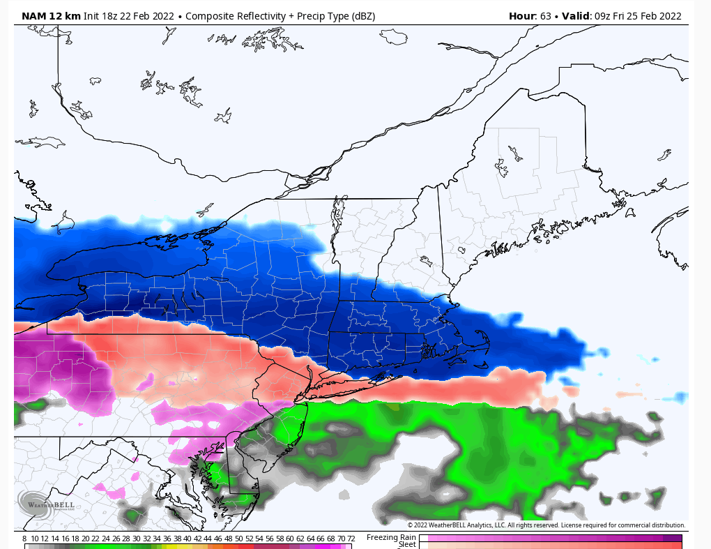
NAM - JUICING UP THE HP ADN KNOCKING BACK TEH SE RIDGE A TAD
Mike Mostwill post
.gif.15a7d21dc74e7e4fe2e38846ce11954f.gif)
Mike Mostwill post
.gif.15a7d21dc74e7e4fe2e38846ce11954f.gif)
_________________
Mugs
AKA:King: Snow Weenie
Self Proclaimed
WINTER 2014-15 : 55.12" +.02 for 6 coatings (avg. 35")
WINTER 2015-16 Total - 29.8" (Avg 35")
WINTER 2016-17 : 39.5" so far

amugs- Advanced Forecaster - Mod

- Posts : 15095
Reputation : 213
Join date : 2013-01-07
Age : 54
Location : Hillsdale,NJ
 Re: February 25th 2022 potential snow/ice for mainly well NW of I95
jmanley32 wrote:thats some serious frz, is that on top of the 4-6 inches the euro now shows? anyone have the ice map for that?amugs wrote:sroc4 wrote:Heehaw we never close off at 850 or 700 and 850's have multi focal vort max's. The front end thump you have 700 screaming out of the west and 850 out of the SW and not S, SE or E like when you get that close 850 low. Larry Cosgrove taught me a long time ago that when you see 700mb out of the west with an over runing event without any of the midl evels closing off it screams of correcting colder and snowier. It would not surprise me if the mid level trends cont we get colder and snowier down to the coast.
Cosgrove said over the weekend that this would be a snow to ice scenario with serious potential from CNJ N.
Euro keeps trending S and it is picking up on the W to E flow from the TPV press The Euro has corrected as much as the GFS you can say but the GFS was on this with a snowstorm last Thursday. Did it see the ice - not really but have to give it credence here. Euro was up to Buffalo now it is in Rockville MD.
Even Rayno this morning echoed Cosgrove's idea as does JB, that is tough trio to go against.
Still a few more runs to go and then we look at Meso's to see where that warm nose is etc.
Temps crash behind it as well - UGLY sitch peeps

_________________
Mugs
AKA:King: Snow Weenie
Self Proclaimed
WINTER 2014-15 : 55.12" +.02 for 6 coatings (avg. 35")
WINTER 2015-16 Total - 29.8" (Avg 35")
WINTER 2016-17 : 39.5" so far

amugs- Advanced Forecaster - Mod

- Posts : 15095
Reputation : 213
Join date : 2013-01-07
Age : 54
Location : Hillsdale,NJ
 Re: February 25th 2022 potential snow/ice for mainly well NW of I95
Anyone have the Euro frz map? It looked pretty bad from the surface map.

jmanley32- Senior Enthusiast

- Posts : 20535
Reputation : 108
Join date : 2013-12-12
Age : 43
Location : Yonkers, NY
 Re: February 25th 2022 potential snow/ice for mainly well NW of I95
_________________
Mugs
AKA:King: Snow Weenie
Self Proclaimed
WINTER 2014-15 : 55.12" +.02 for 6 coatings (avg. 35")
WINTER 2015-16 Total - 29.8" (Avg 35")
WINTER 2016-17 : 39.5" so far

amugs- Advanced Forecaster - Mod

- Posts : 15095
Reputation : 213
Join date : 2013-01-07
Age : 54
Location : Hillsdale,NJ

hyde345- Pro Enthusiast

- Posts : 1082
Reputation : 48
Join date : 2013-01-08
Location : Hyde Park, NY
 Re: February 25th 2022 potential snow/ice for mainly well NW of I95
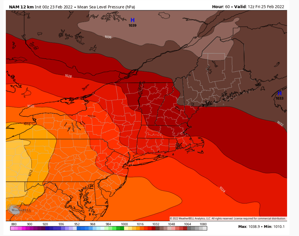
The TPV will pin the H and force a redirection of the storm. This will produce ice and I have little doubt on that. Hopefully it's more ip than zr. I think it could be cold enough to support ip for most areas for most of the event. That is a robust H for sure and you see the bend of the isobars at the surface. Where you see the last bend (EPA) my guess is the surface to 3000 feet ASL doesn't get above freezing for 90% of the precip.

heehaw453- Advanced Forecaster

- Posts : 3906
Reputation : 86
Join date : 2014-01-20
Location : Bedminster Township, PA Elevation 600' ASL
 Re: February 25th 2022 potential snow/ice for mainly well NW of I95
It's the kind of storm where you'll report snow and then you'll hear pingers 5 minutes later. Then as rates increase you'll say it's back to snow. As the precip rates increase snow will become more possible and as they lighten up you'll get ip. Overall all though it's rough to accumulate big amounts with this column. This is the weather though so I'm stoked to see who can surprise on this.
heehaw453- Advanced Forecaster

- Posts : 3906
Reputation : 86
Join date : 2014-01-20
Location : Bedminster Township, PA Elevation 600' ASL
 Re: February 25th 2022 potential snow/ice for mainly well NW of I95
Good model runs tonight euro ukie GFS and nam are all advisory snows for New York City And warning level snows North of 287 Followed by ice most likely sleet from the city North and West

algae888- Advanced Forecaster

- Posts : 5311
Reputation : 46
Join date : 2013-02-05
Age : 62
Location : mt. vernon, new york
 Re: February 25th 2022 potential snow/ice for mainly well NW of I95
WSW for all except coast and central eastern nj, darn but it is almost march gotta take what we can get shoot 2-5 for coast and mothra level snows to the north? You guys were saying we probably wouldnt make it to warning level snows well apparently NWS does, NAM still has no snow for the entire area...weird.

jmanley32- Senior Enthusiast

- Posts : 20535
Reputation : 108
Join date : 2013-12-12
Age : 43
Location : Yonkers, NY
 Re: February 25th 2022 potential snow/ice for mainly well NW of I95
Winter storm watch for my area NW NJ first one for Warren co this year !!!


snowbunny- Posts : 3
Reputation : 0
Join date : 2021-12-25
RJB8525 and SENJsnowman like this post
 Re: February 25th 2022 potential snow/ice for mainly well NW of I95
As Gabby Hayes used to say on the Roy Rogers TV Show,,,"I'll be hornswoggled"!
Winter storm watch out here for 4 to 8 inches.Hopefully it stays as snow for as long as possible.Funny thing, I am down to one snow pile at the end of my driveway.The cavalry to the rescue,LOL.
Winter storm watch out here for 4 to 8 inches.Hopefully it stays as snow for as long as possible.Funny thing, I am down to one snow pile at the end of my driveway.The cavalry to the rescue,LOL.

docstox12- Wx Statistician Guru

- Posts : 8530
Reputation : 222
Join date : 2013-01-07
Age : 73
Location : Monroe NY
jmanley32 likes this post
 Re: February 25th 2022 potential snow/ice for mainly well NW of I95
jmanley32 wrote:WSW for all except coast and central eastern nj, darn but it is almost march gotta take what we can get shoot 2-5 for coast and mothra level snows to the north? You guys were saying we probably wouldnt make it to warning level snows well apparently NWS does, NAM still has no snow for the entire area...weird.
Nothing has changed with this storm for a few days now IMO. We unfortunately have 1/2 the synoptic equation for this storm to get sig snowfall. The beautiful H to the north will enforce low level cold and the WAA from the western storm will go over the dense cold air for ip/zr. IMO the rdps (Canadian meso) presentation is what I'd expect based on the synoptics.
North of Poughkeepsie they are far enough north to mitigate the major WAA effects, but even there it will mix. Jackpot is north of I-90.
The concern is how bad the zr gets around the interior I78 corridor. Hopefully it's more ip than zr.
I'm not trying to poo poo this for anyone, but truly believe snow will underwhelm on this one for many folks in the forum. We needed this mid level energy to pull off the coast around WV and then this would be another animal.
heehaw453- Advanced Forecaster

- Posts : 3906
Reputation : 86
Join date : 2014-01-20
Location : Bedminster Township, PA Elevation 600' ASL
 Re: February 25th 2022 potential snow/ice for mainly well NW of I95
I just wanted to share a good basic pdf of the physics behind cold air damming. Hopefully, everyone can be more clear as to the mechanisms behind it.
Generally, it has to do with a resulting geostrophic adjustment on the east side (along the east coast) of mountain ranges creating an ageostrophic return flow parallel and opposite to the orientation of mountain ranges.
Starts on page 17:
http://twister.caps.ou.edu/MM2015/docs/chapter2/chapter2_presentation3.pdf

Quietace- Meteorologist - Mod

- Posts : 3689
Reputation : 33
Join date : 2013-01-07
Age : 27
Location : Point Pleasant, NJ
 Re: February 25th 2022 potential snow/ice for mainly well NW of I95
CAD Galore NG this is a bit overdone but even 50% of this is trouble!
WxLover 33 n rain board

WxLover 33 n rain board

_________________
Mugs
AKA:King: Snow Weenie
Self Proclaimed
WINTER 2014-15 : 55.12" +.02 for 6 coatings (avg. 35")
WINTER 2015-16 Total - 29.8" (Avg 35")
WINTER 2016-17 : 39.5" so far

amugs- Advanced Forecaster - Mod

- Posts : 15095
Reputation : 213
Join date : 2013-01-07
Age : 54
Location : Hillsdale,NJ
 Re: February 25th 2022 potential snow/ice for mainly well NW of I95
Terrible FR map there Mugs.I am just above it.Hope that means all snow/sleet.

docstox12- Wx Statistician Guru

- Posts : 8530
Reputation : 222
Join date : 2013-01-07
Age : 73
Location : Monroe NY
 Re: February 25th 2022 potential snow/ice for mainly well NW of I95
NWS has me at 6-12 not much mixing expected up here! I can see some sleet getting up to 84 but not expecting any FRZ.
jimv45- Senior Enthusiast

- Posts : 1168
Reputation : 36
Join date : 2013-09-20
Location : Hopewell jct.
heehaw453 likes this post
 Re: February 25th 2022 potential snow/ice for mainly well NW of I95
12Z NAM is off its rocker still IMO w.r.t. to snowfall. I wouldn't buy into its snow maps for those NW. It's bad synoptically, but IMO not that bad. Probably next few runs it corrects...
heehaw453- Advanced Forecaster

- Posts : 3906
Reputation : 86
Join date : 2014-01-20
Location : Bedminster Township, PA Elevation 600' ASL
Page 3 of 9 •  1, 2, 3, 4, 5, 6, 7, 8, 9
Permissions in this forum:
You cannot reply to topics in this forum|
|
|

 Home
Home