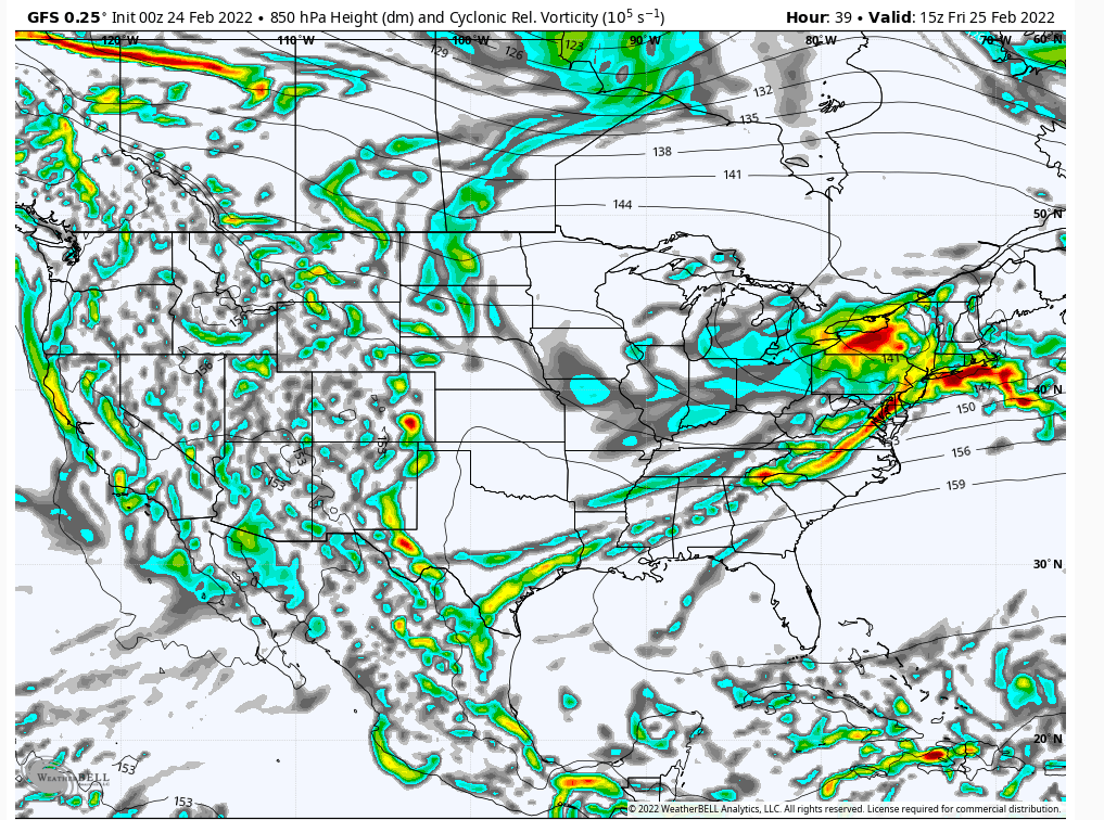
February 25th 2022 potential snow/ice for mainly well NW of I95
+30
dkodgis
mmanisca
Radz
2004blackwrx
WeatherBob
Frozen.9
1190ftalt
Taffy
essexcountypete
Sparky Sparticles
weatherwatchermom
SkiSeadooJoe
Snow88
brownie
RJB8525
SENJsnowman
Quietace
snowbunny
algae888
billg315
aiannone
sroc4
docstox12
jimv45
hyde345
amugs
frank 638
Frank_Wx
jmanley32
heehaw453
34 posters
Page 5 of 9 •  1, 2, 3, 4, 5, 6, 7, 8, 9
 Re: February 25th 2022 potential snow/ice for mainly well NW of I95
Euro is starting to catch on. Let’s see if it’s a blip or do we see others follow suite.
sroc4- Admin

- Posts : 8354
Join date : 2013-01-07
 Re: February 25th 2022 potential snow/ice for mainly well NW of I95
Euro is colder this run
Snow88- Senior Enthusiast

- Posts : 2193
Join date : 2013-01-09
 Re: February 25th 2022 potential snow/ice for mainly well NW of I95
Wow sroc. you ain't kiddin. It doesn't look like noise to me. The low doesn't get anywhere the strength as it lifts because it's being pressed more by a full banana H. That's a huge difference. If that's not a bs run then the L is going to be transferring much faster and I'd argue that a further bump south is likely. 00z will tell us if this was a just a misinterpretation or not.
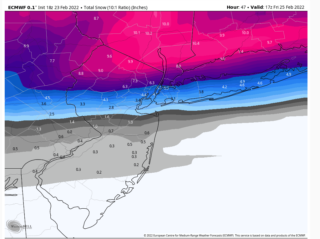
12Z Surface
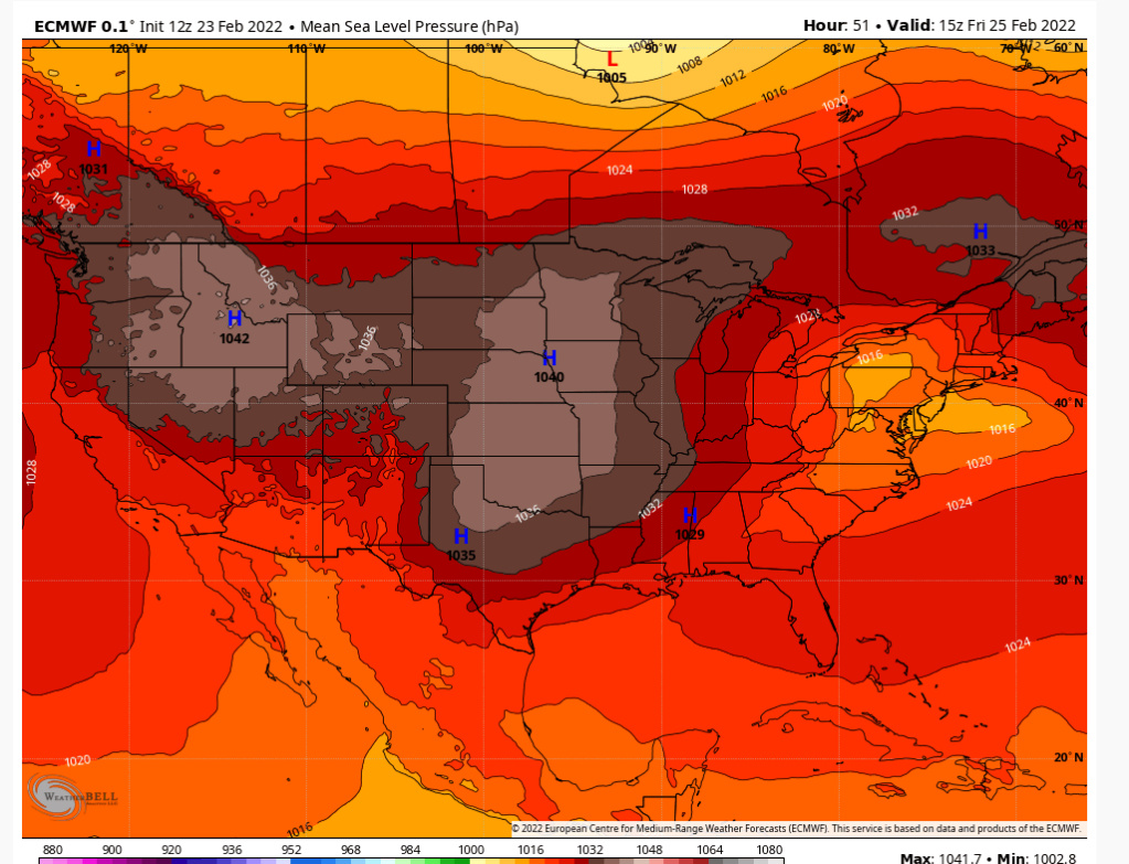
18Z Surface
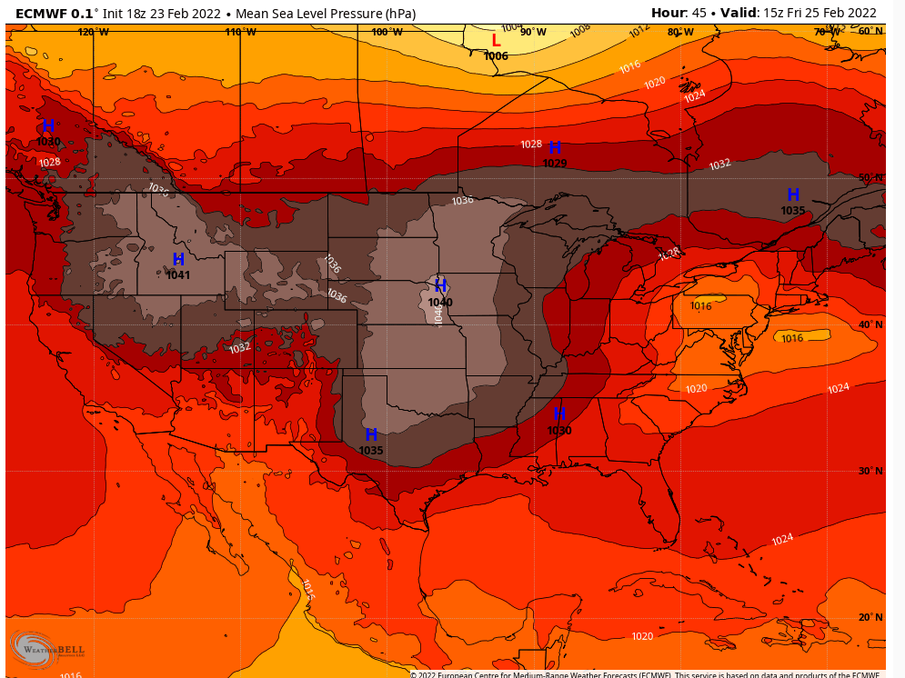

12Z Surface

18Z Surface

heehaw453- Advanced Forecaster

- Posts : 3906
Reputation : 86
Join date : 2014-01-20
Location : Bedminster Township, PA Elevation 600' ASL
sroc4 likes this post
 Re: February 25th 2022 potential snow/ice for mainly well NW of I95
Is that all snow? Ill take 6 inches being I was expecting ice and rain.heehaw453 wrote:Wow sroc. you ain't kiddin. It doesn't look like noise to me. The low doesn't get anywhere the strength as it lifts because it's being pressed more by a full banana H. That's a huge difference. If that's not a bs run then the L is going to be transferring much faster and I'd argue that a further bump south is likely. 00z will tell us if this was a just a misinterpretation or not.
12Z Surface
18Z Surface

jmanley32- Senior Enthusiast

- Posts : 20535
Reputation : 108
Join date : 2013-12-12
Age : 43
Location : Yonkers, NY
 Re: February 25th 2022 potential snow/ice for mainly well NW of I95
jmanley32 wrote:Is that all snow? Ill take 6 inches being I was expecting ice and rain.heehaw453 wrote:Wow sroc. you ain't kiddin. It doesn't look like noise to me. The low doesn't get anywhere the strength as it lifts because it's being pressed more by a full banana H. That's a huge difference. If that's not a bs run then the L is going to be transferring much faster and I'd argue that a further bump south is likely. 00z will tell us if this was a just a misinterpretation or not.
12Z Surface
18Z Surface
Need another run to see if this has legs. But the 18Z run was the best push against the L that I've seen from the Euro in days.
heehaw453- Advanced Forecaster

- Posts : 3906
Reputation : 86
Join date : 2014-01-20
Location : Bedminster Township, PA Elevation 600' ASL
 Re: February 25th 2022 potential snow/ice for mainly well NW of I95
It's hard to keep looking at these Euro and GFS runs (and the early HRRR runs) and not suspect that there is something to this colder push and more suppressed energy. That Euro run not only buries a good part of the region under several inches of a front end thump snow, but has over a half inch of ice in Central NJ where the changeover occurs after 1-3" of snow.

billg315- Advanced Forecaster - Mod

- Posts : 4483
Reputation : 185
Join date : 2015-01-24
Age : 50
Location : Flemington, NJ
heehaw453- Advanced Forecaster

- Posts : 3906
Reputation : 86
Join date : 2014-01-20
Location : Bedminster Township, PA Elevation 600' ASL
 Re: February 25th 2022 potential snow/ice for mainly well NW of I95
When you posted this site's map earlier I kind of blew it off as overly aggressive on the snow totals. Now looking at the Euro . . . I'm not so sure?

billg315- Advanced Forecaster - Mod

- Posts : 4483
Reputation : 185
Join date : 2015-01-24
Age : 50
Location : Flemington, NJ
 Re: February 25th 2022 potential snow/ice for mainly well NW of I95
billg315 wrote:
When you posted this site's map earlier I kind of blew it off as overly aggressive on the snow totals. Now looking at the Euro . . . I'm not so sure?
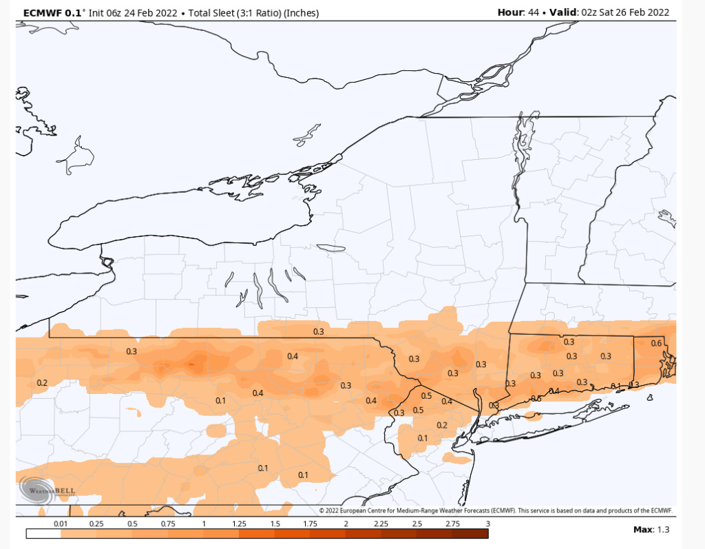
I quickly read the paper on the algorithm. It tries to adjust for compaction based on surface temps, but also looks at the thermal profiles and saturation of the column at different levels to adjust the the snow ratio. Gives sleet to liquid as 1:1 which is normally it's 3:1. I don't have enough meteorology training to dispute or bolster it, but curious to see how it does with this storm.
heehaw453- Advanced Forecaster

- Posts : 3906
Reputation : 86
Join date : 2014-01-20
Location : Bedminster Township, PA Elevation 600' ASL
sroc4 and SENJsnowman like this post
 Re: February 25th 2022 potential snow/ice for mainly well NW of I95
0z NAM is further south with the cold press. Brings accumulating snow about 50 miles south of previous run. Still not showing totals like the Euro or GFS, but trended toward them. About 2-3" in far north NJ and 4-5" in the LHV. Still plenty of ice in Central and North NJ.

billg315- Advanced Forecaster - Mod

- Posts : 4483
Reputation : 185
Join date : 2015-01-24
Age : 50
Location : Flemington, NJ
 Re: February 25th 2022 potential snow/ice for mainly well NW of I95
The NAM's movement toward the Euro/GFS, if it holds overnight, would really clarify things for me. I increasingly think there will be a good front-end thump of snow for folks north of I-80 (and maybe even I-78) and the ice threat seems locked in. All three models have areas of our forum getting .25 to .50" of ice. That is way more than a light glaze. As someone said earlier, if we get even half of that in those areas it will be very dangerous.

billg315- Advanced Forecaster - Mod

- Posts : 4483
Reputation : 185
Join date : 2015-01-24
Age : 50
Location : Flemington, NJ
 Re: February 25th 2022 potential snow/ice for mainly well NW of I95
^^^ Bill, I laoted a map yesterday and said the HP is anchored SE Can and this has a significant snow and ice storm written all over it all 93-94. WeatherBob also states this two night ago. Its coming together and the models are latching on.
Not being an alarmist here but this is going to be a pretty serious storm overall if these maps verify for snow and ice.
Maybe a Zoom tomorrow night if warrants but NO IMBY questions.
The suite since yesterday has ticked S with each successive run for 6 runs now.
Not being an alarmist here but this is going to be a pretty serious storm overall if these maps verify for snow and ice.
Maybe a Zoom tomorrow night if warrants but NO IMBY questions.
The suite since yesterday has ticked S with each successive run for 6 runs now.
_________________
Mugs
AKA:King: Snow Weenie
Self Proclaimed
WINTER 2014-15 : 55.12" +.02 for 6 coatings (avg. 35")
WINTER 2015-16 Total - 29.8" (Avg 35")
WINTER 2016-17 : 39.5" so far

amugs- Advanced Forecaster - Mod

- Posts : 15095
Reputation : 213
Join date : 2013-01-07
Age : 54
Location : Hillsdale,NJ
jmanley32 and billg315 like this post
 Re: February 25th 2022 potential snow/ice for mainly well NW of I95
Looks like I will be in primo spot for 6+ of snow in eastern CT, heading tomorrow afternoon/evening. I will report from there. Any sig icing threat for NYC area or mainly stays in NJ and west?

jmanley32- Senior Enthusiast

- Posts : 20535
Reputation : 108
Join date : 2013-12-12
Age : 43
Location : Yonkers, NY
 Re: February 25th 2022 potential snow/ice for mainly well NW of I95
I will say frank not chiming in does tell me something though that this may not work out, he did make one post that he was not enthused, it appears still feels same way or I would think he would posted.

jmanley32- Senior Enthusiast

- Posts : 20535
Reputation : 108
Join date : 2013-12-12
Age : 43
Location : Yonkers, NY
 Re: February 25th 2022 potential snow/ice for mainly well NW of I95
I said this yesterday and it bears repeating. Even if we got a stronger warm push and a quicker changeover to plain rain . . . if that doesn't happen until mid-morning, the damage is done. This snow/sleet/freezing rain will be going for several hours before the Friday AM rush hour and right through it. So it will have major impacts unless these models are all WAY off and it changes to rain across most of the area before 4 or 5 a.m.

billg315- Advanced Forecaster - Mod

- Posts : 4483
Reputation : 185
Join date : 2015-01-24
Age : 50
Location : Flemington, NJ
 Re: February 25th 2022 potential snow/ice for mainly well NW of I95
Btw, with regard to the air mass this will be running into: After hitting the upper 60s here this afternoon, it is now 38* with a dewpoint of 23*. This cold air is crashing in and doesn't seem likely to budge quickly once it settles over us tomorrow and tomorrow night.

billg315- Advanced Forecaster - Mod

- Posts : 4483
Reputation : 185
Join date : 2015-01-24
Age : 50
Location : Flemington, NJ
hyde345 likes this post
 Re: February 25th 2022 potential snow/ice for mainly well NW of I95
billg315 wrote:Btw, with regard to the air mass this will be running into: After hitting the upper 60s here this afternoon, it is now 38* with a dewpoint of 23*. This cold air is crashing in and doesn't seem likely to budge quickly once it settles over us tomorrow and tomorrow night.
Yup. After hitting a high of 66 early this afternoon Im sitting at 32 right now. Looking at 6+ in MHV.

hyde345- Pro Enthusiast

- Posts : 1082
Reputation : 48
Join date : 2013-01-08
Location : Hyde Park, NY
billg315 likes this post
 Re: February 25th 2022 potential snow/ice for mainly well NW of I95
The models still showing volatility as per 00Z rgem. 50/75 miles further press to the south will have large impacts in snow/ice potential. This can bust either way atm, but another run like that 18Z Euro at this range would bolster the bust high snow suspicions.
heehaw453- Advanced Forecaster

- Posts : 3906
Reputation : 86
Join date : 2014-01-20
Location : Bedminster Township, PA Elevation 600' ASL
billg315 likes this post
 Re: February 25th 2022 potential snow/ice for mainly well NW of I95
billg315 wrote:Btw, with regard to the air mass this will be running into: After hitting the upper 60s here this afternoon, it is now 38* with a dewpoint of 23*. This cold air is crashing in and doesn't seem likely to budge quickly once it settles over us tomorrow and tomorrow night.
Low level cold is not moving out especially along and north of I78. It's the 5500-7500' that is the question and that is going to depend on how strong the 850mb/700mb western vorticity max is and how far north it gets. I'm skeptical of betting against the warm nose.
heehaw453- Advanced Forecaster

- Posts : 3906
Reputation : 86
Join date : 2014-01-20
Location : Bedminster Township, PA Elevation 600' ASL
 Re: February 25th 2022 potential snow/ice for mainly well NW of I95
0z GFS should be running soon. We'll see where this takes us.

billg315- Advanced Forecaster - Mod

- Posts : 4483
Reputation : 185
Join date : 2015-01-24
Age : 50
Location : Flemington, NJ
 Re: February 25th 2022 potential snow/ice for mainly well NW of I95
0z GFS slightly warmer. Retreated a little to the north on snow accumulations (actually close to what the 0z NAM shows) and cut back slightly on the ice totals. Not a huge change, but a shift. One could say it came closer into agreement with the NAM (as the NAM moved closer to it as well). But, I'm sure we'll see more slight shifts overnight and tomorrow as this is a complex set-up, so I'd not read too much into these minor changes on any one model run right now.

billg315- Advanced Forecaster - Mod

- Posts : 4483
Reputation : 185
Join date : 2015-01-24
Age : 50
Location : Flemington, NJ
heehaw453- Advanced Forecaster

- Posts : 3906
Reputation : 86
Join date : 2014-01-20
Location : Bedminster Township, PA Elevation 600' ASL
 Re: February 25th 2022 potential snow/ice for mainly well NW of I95
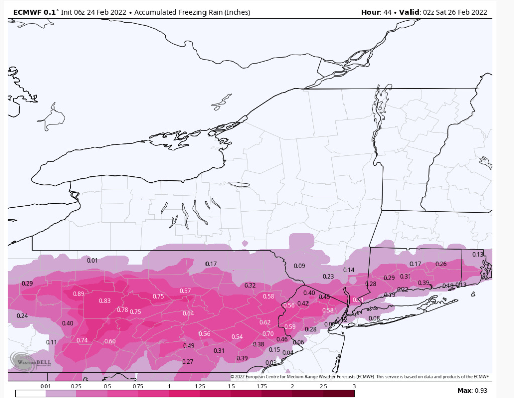
6z NAM and GFS both keep most significant snow well north of the NY/NJ line toward I-84. They have come into line on that. But the NAM nukes the area with .5 to .75” of ice. GFS is more reserved on ice amounts but still problematic.
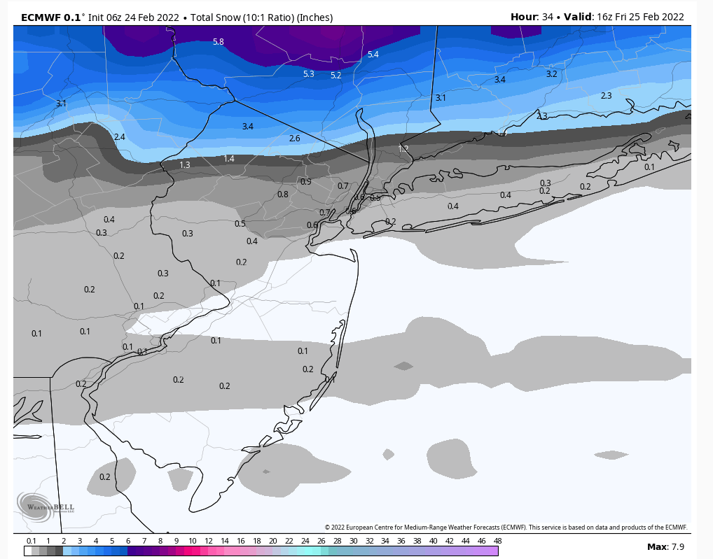
As of now the ice aspect remains the bigger threat than snow south of a line from Stroudsburg PA to just north of NYC. Either way the AM commute tomorrow is rough with some snow and sleet going over to potentially significant ice everywhere north of I-195 in Central NJ.
Most areas of North Jersey don’t go over to plain rain until after noon which on duration alone is a problem.

billg315- Advanced Forecaster - Mod

- Posts : 4483
Reputation : 185
Join date : 2015-01-24
Age : 50
Location : Flemington, NJ
 Re: February 25th 2022 potential snow/ice for mainly well NW of I95
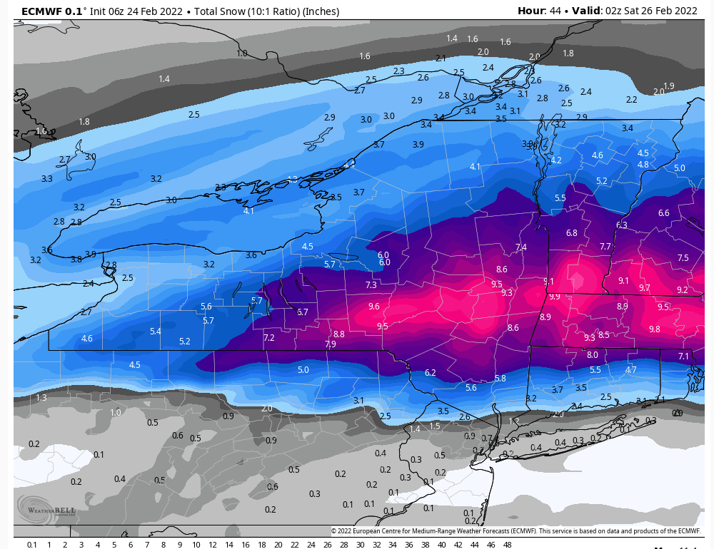
Despite the GFS retreating a bit north on its accumulating snow where it has met the NAM (which trended south last night) in the middle, there still is likely some snow to be had on the front end of this before the ice aspect takes over. And areas in the MHV and north of course should see some nice accumulation.

billg315- Advanced Forecaster - Mod

- Posts : 4483
Reputation : 185
Join date : 2015-01-24
Age : 50
Location : Flemington, NJ
 Re: February 25th 2022 potential snow/ice for mainly well NW of I95
This is very close to what I'd expect for this synoptics of this storm. I think very close now to consensus. Cut the ice accretion in half IMO. This will be a miss for snow for most in this forum as we just don't have the synoptics. The ice will be borderline sig IMO, but shouldn't affect power lines too much hopefully.


heehaw453- Advanced Forecaster

- Posts : 3906
Reputation : 86
Join date : 2014-01-20
Location : Bedminster Township, PA Elevation 600' ASL
 Re: February 25th 2022 potential snow/ice for mainly well NW of I95
Wipers back and forth they go. Have we seen the last of the back and forth, in which case then warmer she goes, or do we go back the other way one last time? I’m sticking with my colder soln because that’s my bias as well as some of the actual reasoning prev stated.
_________________
"In weather and in life, there's no winning and losing; there's only winning and learning."
WINTER 2012/2013 TOTALS 43.65"WINTER 2017/2018 TOTALS 62.85" WINTER 2022/2023 TOTALS 4.9"
WINTER 2013/2014 TOTALS 64.85"WINTER 2018/2019 TOTALS 14.25" WINTER 2023/2024 TOTALS 13.1"
WINTER 2014/2015 TOTALS 71.20"WINTER 2019/2020 TOTALS 6.35"
WINTER 2015/2016 TOTALS 35.00"WINTER 2020/2021 TOTALS 37.75"
WINTER 2016/2017 TOTALS 42.25"WINTER 2021/2022 TOTALS 31.65"

sroc4- Admin

- Posts : 8354
Reputation : 302
Join date : 2013-01-07
Location : Wading River, LI
 Re: February 25th 2022 potential snow/ice for mainly well NW of I95
sroc4 wrote:Wipers back and forth they go. Have we seen the last of the back and forth, in which case then warmer she goes, or do we go back the other way one last time? I’m sticking with my colder soln because that’s my bias as well as some of the actual reasoning prev stated.
That was awesome...and I'd say you do a great job of balancing the bias in your analysis. I mean if there is a 'half full' to be told, I want to know all about it for sure lol
SENJsnowman- Senior Enthusiast

- Posts : 1189
Reputation : 61
Join date : 2017-01-06
Age : 51
Location : Bayville, NJ
Page 5 of 9 •  1, 2, 3, 4, 5, 6, 7, 8, 9
Permissions in this forum:
You cannot reply to topics in this forum|
|
|

 Home
Home
