February 2019 Observations and Discussions
+28
Quietace
jmanley32
SoulSingMG
Dunnzoo
Frankdp23
brownie
algae888
sroc4
1190ftalt
Grselig
essexcountypete
Dtone
aiannone
Frank_Wx
docstox12
Radz
hyde345
nujerzeedevil
billg315
Smitty623
larryrock72
SENJsnowman
amugs
weatherwatchermom
heehaw453
dkodgis
frank 638
CPcantmeasuresnow
32 posters
Page 6 of 10
Page 6 of 10 •  1, 2, 3, 4, 5, 6, 7, 8, 9, 10
 Re: February 2019 Observations and Discussions
30.0° and the ice world Hoth outside my window.
0.8 inches of snow followed by a lot of ice which I refuse to measure.
24.9 inches on the season here. NYC now at an even 10.0 inches avoiding becoming only the tenth season in history of a single digit seasonal total.
I'm still hopeful seasonal averages can be reached but at this point in time even if they somehow were this winter will still rank as awful.
CPcantmeasuresnow- Wx Statistician Guru

- Posts : 7274
Join date : 2013-01-07
brownie- Posts : 393
Join date : 2013-11-10
 Re: February 2019 Observations and Discussions
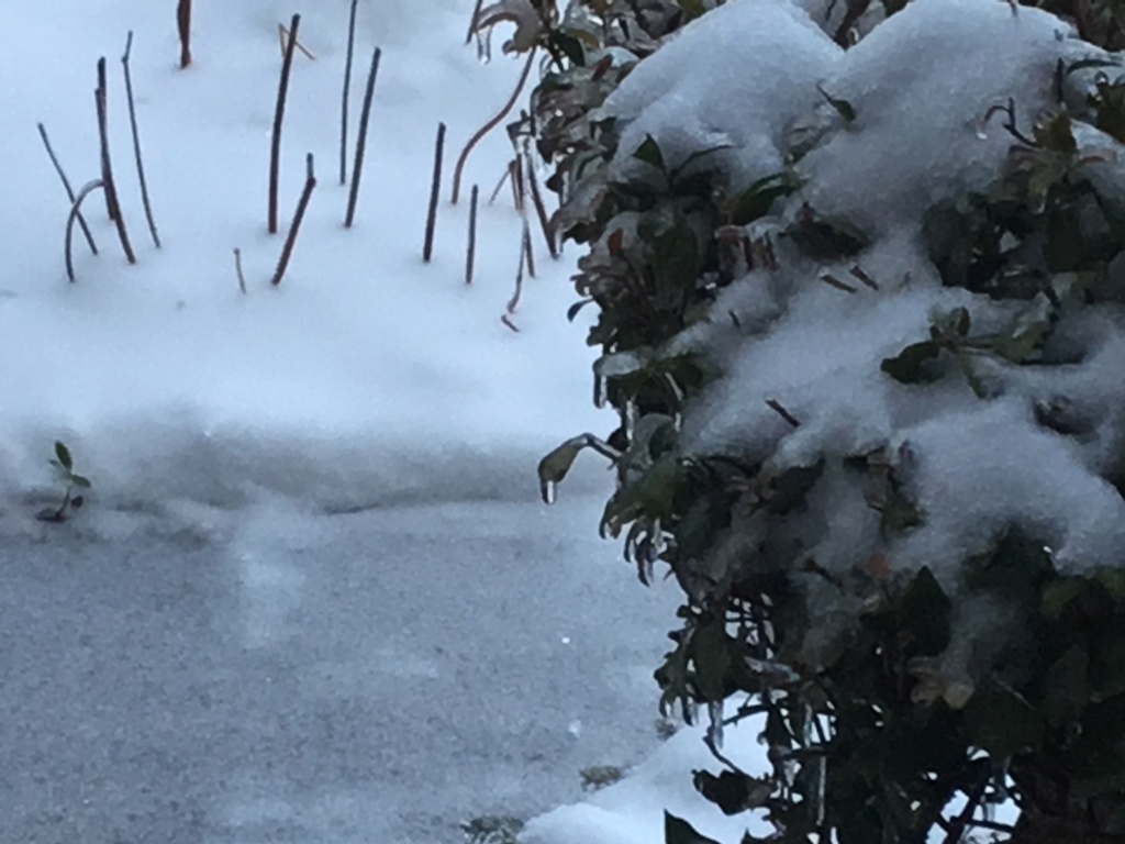
29 this morning, and it looks like 3 inches including the ice; according to the trees, at least 1/4 inch or a bit more. I am surprised the pines are making it They are all moussed down with ice. Looks pretty but pretty bad too though the plow guy says the roads are not bad. Unscientifically looking at the recycling can lid, it looks like 3/8 inch of rock hard ice crust ...the kind I can't even crack with a fist. I would vote for a three hour delay up here the way I see things.

dkodgis- Senior Enthusiast

- Posts : 2560
Reputation : 98
Join date : 2013-12-29
 Re: February 2019 Observations and Discussions
WOW what a layer of ice on everything here this morning I'd have to say a good .10-.15" of coating everything maybe a bit more.
Side streets were not good, main roads were okay overall, some town were getting spreaders out as I was driving at 7AM.
Slop storm but felt like winter for a day and a morning.
Side streets were not good, main roads were okay overall, some town were getting spreaders out as I was driving at 7AM.
Slop storm but felt like winter for a day and a morning.
_________________
Mugs
AKA:King: Snow Weenie
Self Proclaimed
WINTER 2014-15 : 55.12" +.02 for 6 coatings (avg. 35")
WINTER 2015-16 Total - 29.8" (Avg 35")
WINTER 2016-17 : 39.5" so far

amugs- Advanced Forecaster - Mod

- Posts : 15095
Reputation : 213
Join date : 2013-01-07
Age : 54
Location : Hillsdale,NJ
 Re: February 2019 Observations and Discussions
Received just under 2" yesterday and a nice glaze of ice this morning, probably about .15".
Frankdp23- Posts : 11
Reputation : 1
Join date : 2018-02-28
Age : 45
Location : Branchburg, NJ
 Re: February 2019 Observations and Discussions
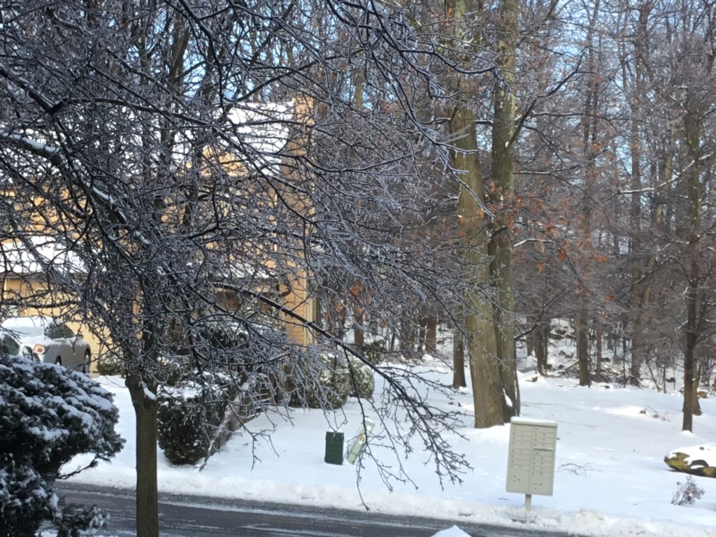
Thanks Brownie! Looks awesome, minus the treacherous ice of course. That should melt soon if it hasn’t already, right?
SENJsnowman- Senior Enthusiast

- Posts : 1189
Reputation : 61
Join date : 2017-01-06
Age : 51
Location : Bayville, NJ
 Re: February 2019 Observations and Discussions
I took those photos before I left for work this morning. There were trees like that all along my route to work, and those in the sun were already dripping and mostly melted at 8 am.SENJsnowman wrote:Thanks Brownie! Looks awesome, minus the treacherous ice of course. That should melt soon if it hasn’t already, right?
brownie- Posts : 393
Reputation : 17
Join date : 2013-11-10
Location : Parsippany, NJ
 Re: February 2019 Observations and Discussions
1.5" of snow and .13" of freezing rain. Everything looked beautiful this morning and melting off nicely. 46° now.
_________________
Janet
Snowfall winter of 2023-2024 17.5"
Snowfall winter of 2022-2023 6.0"
Snowfall winter of 2021-2022 17.6" 1" sleet 2/25/22
Snowfall winter of 2020-2021 51.1"
Snowfall winter of 2019-2020 8.5"
Snowfall winter of 2018-2019 25.1"
Snowfall winter of 2017-2018 51.9"
Snowfall winter of 2016-2017 45.6"
Snowfall winter of 2015-2016 29.5"
Snowfall winter of 2014-2015 50.55"
Snowfall winter of 2013-2014 66.5"
Dunnzoo- Senior Enthusiast - Mod

- Posts : 4904
Reputation : 68
Join date : 2013-01-11
Age : 62
Location : Westwood, NJ
 Re: February 2019 Observations and Discussions
amugs wrote:WOW what a layer of ice on everything here this morning I'd have to say a good .10-.15" of coating everything maybe a bit more.
Side streets were not good, main roads were okay overall, some town were getting spreaders out as I was driving at 7AM.
Slop storm but felt like winter for a day and a morning.
Not bad estimation by my untrained eye huh zoo LOL!! Thanks for the official measurements there stormspotter!!
_________________
Mugs
AKA:King: Snow Weenie
Self Proclaimed
WINTER 2014-15 : 55.12" +.02 for 6 coatings (avg. 35")
WINTER 2015-16 Total - 29.8" (Avg 35")
WINTER 2016-17 : 39.5" so far

amugs- Advanced Forecaster - Mod

- Posts : 15095
Reputation : 213
Join date : 2013-01-07
Age : 54
Location : Hillsdale,NJ
 Re: February 2019 Observations and Discussions
Sunny, 47 degrees.With yesterday's 1.3 inches, I am at 25.5 inches for the season, way below normal but considering the horrible pattern, not as bad as it could have been.

docstox12- Wx Statistician Guru

- Posts : 8530
Reputation : 222
Join date : 2013-01-07
Age : 73
Location : Monroe NY
 Re: February 2019 Observations and Discussions
Winds on Monday are gonna be fierce by the looks of it (cc Jman  )
)

SoulSingMG- Senior Enthusiast

- Posts : 2853
Reputation : 74
Join date : 2013-12-11
Location : Long Island City, NY
 Re: February 2019 Observations and Discussions
SoulSingMG wrote:Winds on Monday are gonna be fierce by the looks of it (cc Jman)
Upton: "Outside of aforementioned rain, there will be a significant
strengthening in winds as the system begins to depart, and cold
advection strengthens Sunday night into Monday night. At the
very least a wind advisory may be needed, though there is
potential for a few hours of winds bordering on high wind -
sustained 40 mph with gusts close to 58 mph, especially across
the east end with the departing low level jet Monday morning."

SoulSingMG- Senior Enthusiast

- Posts : 2853
Reputation : 74
Join date : 2013-12-11
Location : Long Island City, NY
 Re: February 2019 Observations and Discussions
Meh I will be stuck inside at work all day, cant even see outside so hope it doesnt work out lolSoulSingMG wrote:SoulSingMG wrote:Winds on Monday are gonna be fierce by the looks of it (cc Jman)
Upton: "Outside of aforementioned rain, there will be a significant
strengthening in winds as the system begins to depart, and cold
advection strengthens Sunday night into Monday night. At the
very least a wind advisory may be needed, though there is
potential for a few hours of winds bordering on high wind -
sustained 40 mph with gusts close to 58 mph, especially across
the east end with the departing low level jet Monday morning."

jmanley32- Senior Enthusiast

- Posts : 20535
Reputation : 108
Join date : 2013-12-12
Age : 43
Location : Yonkers, NY
 Re: February 2019 Observations and Discussions
25.5? Man come on I am sitting here with maybe 10 inches if you scrape up all the little dustings and add in yesterdays 2. Just pathetic, but granted you usually do see more but you do have 2.5x more than here. And I have yet to have anything left the next day on any storms even Nov as it poured all night.docstox12 wrote:Sunny, 47 degrees.With yesterday's 1.3 inches, I am at 25.5 inches for the season, way below normal but considering the horrible pattern, not as bad as it could have been.

jmanley32- Senior Enthusiast

- Posts : 20535
Reputation : 108
Join date : 2013-12-12
Age : 43
Location : Yonkers, NY
 Re: February 2019 Observations and Discussions
I'm at 20" for the season to date. Pattern may become more favorable towards the end of February, but am very skeptical of big bang finish here. 1/3 of the 40" that I got last March would put me to normal snowfall.
heehaw453- Advanced Forecaster

- Posts : 3906
Reputation : 86
Join date : 2014-01-20
Location : Bedminster Township, PA Elevation 600' ASL
 Re: February 2019 Observations and Discussions
heehaw453 wrote:I'm at 20" for the season to date. Pattern may become more favorable towards the end of February, but am very skeptical of big bang finish here. 1/3 of the 40" that I got last March would put me to normal snowfall.
With NYC's 30 year average at 30 inches, at least come Jan 2021 when they re-calculate them, I think you're selling yourself a little short thinking 33 inches is your average.
People are very hung up on the current 30 year snowfall averages which throughout the area are at historic lows because they still include the abysmal 1980's and 1990's in those averages. The current averages everyone looks at are for Jan 1981 - Dec 2010. In less than 2 years when the 1980's are no longer part of the calculation the averages will rise about 5 inches throughout the area.

CPcantmeasuresnow- Wx Statistician Guru

- Posts : 7274
Reputation : 230
Join date : 2013-01-07
Age : 103
Location : Eastern Orange County, NY
 Re: February 2019 Observations and Discussions
CPcantmeasuresnow wrote:heehaw453 wrote:I'm at 20" for the season to date. Pattern may become more favorable towards the end of February, but am very skeptical of big bang finish here. 1/3 of the 40" that I got last March would put me to normal snowfall.
With NYC's 30 year average at 30 inches, at least come Jan 2021 when they re-calculate them, I think you're selling yourself a little short thinking 33 inches is your average.
People are very hung up on the current 30 year snowfall averages which throughout the area are at historic lows because they still include the abysmal 1980's and 1990's in those averages. The current averages everyone looks at are for Jan 1981 - Dec 2010. In less than 2 years when the 1980's are no longer part of the calculation the averages will rise about 5 inches throughout the area.
Personally I think looking at a 30 yr avg is garbage. I think the abysmal years of the 80's and 90's need to be included. The avg should be 100 yrs minimum. Time for you and me vs mother's natures time scale are not one and the same. That's my humble opinion of course.
_________________
"In weather and in life, there's no winning and losing; there's only winning and learning."
WINTER 2012/2013 TOTALS 43.65"WINTER 2017/2018 TOTALS 62.85" WINTER 2022/2023 TOTALS 4.9"
WINTER 2013/2014 TOTALS 64.85"WINTER 2018/2019 TOTALS 14.25" WINTER 2023/2024 TOTALS 13.1"
WINTER 2014/2015 TOTALS 71.20"WINTER 2019/2020 TOTALS 6.35"
WINTER 2015/2016 TOTALS 35.00"WINTER 2020/2021 TOTALS 37.75"
WINTER 2016/2017 TOTALS 42.25"WINTER 2021/2022 TOTALS 31.65"

sroc4- Admin

- Posts : 8354
Reputation : 302
Join date : 2013-01-07
Location : Wading River, LI
 Re: February 2019 Observations and Discussions
sroc4 wrote:CPcantmeasuresnow wrote:heehaw453 wrote:I'm at 20" for the season to date. Pattern may become more favorable towards the end of February, but am very skeptical of big bang finish here. 1/3 of the 40" that I got last March would put me to normal snowfall.
With NYC's 30 year average at 30 inches, at least come Jan 2021 when they re-calculate them, I think you're selling yourself a little short thinking 33 inches is your average.
People are very hung up on the current 30 year snowfall averages which throughout the area are at historic lows because they still include the abysmal 1980's and 1990's in those averages. The current averages everyone looks at are for Jan 1981 - Dec 2010. In less than 2 years when the 1980's are no longer part of the calculation the averages will rise about 5 inches throughout the area.
Personally I think looking at a 30 yr avg is garbage. I think the abysmal years of the 80's and 90's need to be included. The avg should be 100 yrs minimum. Time for you and me vs mother's natures time scale are not one and the same. That's my humble opinion of course.
I agree, but of course everything that's published is the 30 year averages that the NWS decided to go with 100 odd years ago. However in this case for NYC the next calculated 30 year average will be more representative of the norm.
The 150 year snowfall average in NYC is 28.8 inches per season, the new 30 year averages calculated in 2021 will be about 30 inches give or take an inch, pretty much in line with the historical averages.
Where it did skew results was for the 1971-2000 and the current 1981-2010 averages which were 22.2 and 25.8 respectively. These last 20 years the 30 year averages were skewed on the low side. As I stated earlier the upcoming 30 year average 1991-2020 will be in line with the 150 year average.
Last edited by CPcantmeasuresnow on Sat Feb 23, 2019 1:38 pm; edited 1 time in total

CPcantmeasuresnow- Wx Statistician Guru

- Posts : 7274
Reputation : 230
Join date : 2013-01-07
Age : 103
Location : Eastern Orange County, NY
 Re: February 2019 Observations and Discussions
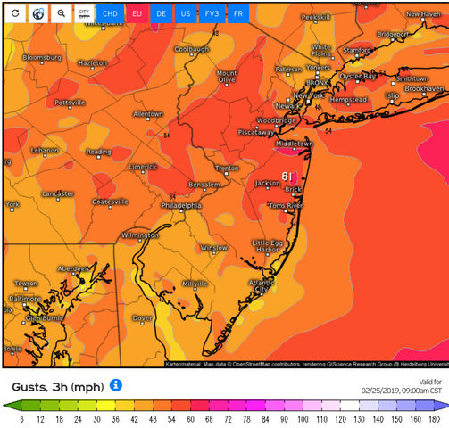
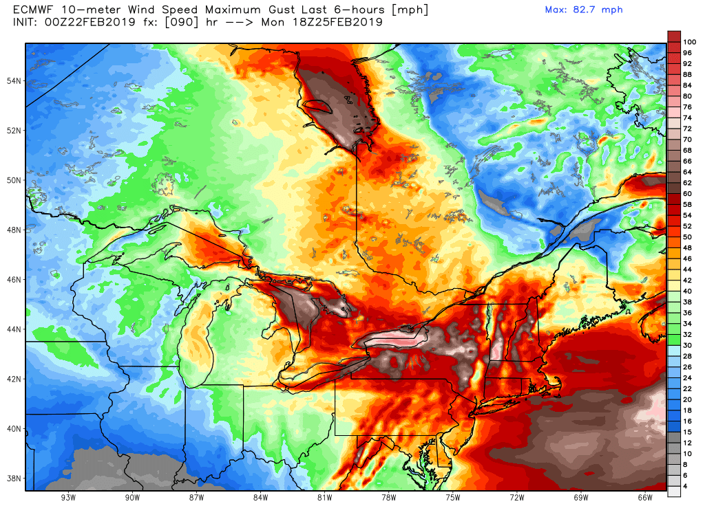
Well if the Euro is right, and the NWS seems to think so as HWW are already hoisted for a abnormally large area of PA and western NY and HWO mentioning HWW potential for the area, it apears the timing will be midday Monday into Monday night which means I may get out of work in time to experience some of it. Here is the Euro wind map, very impressive, usually its spotty with a wind threat but this is the entire area and good lord look at upstate NY 70-80mph! And these behind system wind events pan out more than other wind threats, so we will see.


jmanley32- Senior Enthusiast

- Posts : 20535
Reputation : 108
Join date : 2013-12-12
Age : 43
Location : Yonkers, NY
 Re: February 2019 Observations and Discussions
DAYS TWO THROUGH SEVEN...Sunday through Friday.
Strong low pressure passing through the Great Lakes and into
southeastern Canada Sunday and Monday is expected to produce strong
winds across the area late Sunday night and Monday. While winds are
currently expected to range primarily between 25-35 mph with gusts
between 40-55 mph, there is a low potential for damaging wind gusts
of up to 60 mph.

SoulSingMG- Senior Enthusiast

- Posts : 2853
Reputation : 74
Join date : 2013-12-11
Location : Long Island City, NY

Quietace- Meteorologist - Mod

- Posts : 3689
Reputation : 33
Join date : 2013-01-07
Age : 27
Location : Point Pleasant, NJ
 Re: February 2019 Observations and Discussions
and it's only February...lol...wait till August...(took my son to Disney last week in August, because I did not want to take him out of school....NEVER again...will be taking him out of school to go to Universal..this Oct...lol)hope school is well..your first year of grad school is almost done!!

weatherwatchermom- Senior Enthusiast

- Posts : 3793
Reputation : 78
Join date : 2014-11-25
Location : Hazlet Township, NJ
 Re: February 2019 Observations and Discussions
HIGH WIND WATCH just hoisted region-wide!

SoulSingMG- Senior Enthusiast

- Posts : 2853
Reputation : 74
Join date : 2013-12-11
Location : Long Island City, NY
 Re: February 2019 Observations and Discussions
_________________
Janet
Snowfall winter of 2023-2024 17.5"
Snowfall winter of 2022-2023 6.0"
Snowfall winter of 2021-2022 17.6" 1" sleet 2/25/22
Snowfall winter of 2020-2021 51.1"
Snowfall winter of 2019-2020 8.5"
Snowfall winter of 2018-2019 25.1"
Snowfall winter of 2017-2018 51.9"
Snowfall winter of 2016-2017 45.6"
Snowfall winter of 2015-2016 29.5"
Snowfall winter of 2014-2015 50.55"
Snowfall winter of 2013-2014 66.5"

Dunnzoo- Senior Enthusiast - Mod

- Posts : 4904
Reputation : 68
Join date : 2013-01-11
Age : 62
Location : Westwood, NJ
 Re: February 2019 Observations and Discussions
Light rain occasionally mixed with sleet another lousy boring rain storm
frank 638- Senior Enthusiast

- Posts : 2843
Reputation : 37
Join date : 2016-01-01
Age : 40
Location : bronx ny

skinsfan1177- Senior Enthusiast

- Posts : 4485
Reputation : 35
Join date : 2013-01-07
Age : 46
Location : Point Pleasant Boro
 Re: February 2019 Observations and Discussions
Mount Holly says yes to to the winds.
High Wind Warning
URGENT - WEATHER MESSAGE
National Weather Service Mount Holly NJ
324 AM EST Sun Feb 24 2019
New Castle-Cecil-Middlesex-Western Monmouth-Eastern Monmouth-
Mercer-Salem-Gloucester-Camden-Northwestern Burlington-Ocean-
Cumberland-Atlantic-Cape May-Atlantic Coastal Cape May-
Coastal Atlantic-Coastal Ocean-Southeastern Burlington-Delaware-
Philadelphia-Eastern Chester-Eastern Montgomery-Lower Bucks-
Including the cities of Wilmington, Elkton, New Brunswick,
Freehold, Sandy Hook, Trenton, Pennsville, Glassboro, Camden,
Cherry Hill, Moorestown, Mount Holly, Jackson, Millville,
Hammonton, Cape May Court House, Ocean City, Atlantic City,
Long Beach Island, Wharton State Forest, Media, Philadelphia,
West Chester, Kennett Square, Norristown, Lansdale, Morrisville,
and Doylestown
324 AM EST Sun Feb 24 2019
...HIGH WIND WARNING IN EFFECT FROM 4 PM THIS AFTERNOON TO 6 PM
EST MONDAY...
The National Weather Service in Mount Holly has issued a High
Wind Warning, which is in effect from 4 PM this afternoon to 6 PM
EST Monday. The High Wind Watch is no longer in effect.
* WINDS...West 25 to 35 mph with 55 to 60 mph gusts.
* TIMING...A surge of winds just behind the passage of a strong
cold front early this evening may result in 45 to 55 mph gusts.
Otherwise, winds overnight will generally gust 35 to 45 mph.
Starting Monday morning, strong winds gusting 55 to 60 mph will
affect the area.
* IMPACTS...Strong winds may blow down limbs, trees, and power
lines. Scattered power outages are expected.
* ADDITIONAL DETAILS...The ground is quite saturated, and
additional heavy rainfall this morning will add to this. It
will not take much wind to result in downed trees and power
lines.
PRECAUTIONARY/PREPAREDNESS ACTIONS...
A High Wind Warning means a hazardous high wind event is expected
or occurring. Sustained wind speeds of at least 40 mph or gusts
of 58 mph or more can lead to property damage.

skinsfan1177- Senior Enthusiast

- Posts : 4485
Reputation : 35
Join date : 2013-01-07
Age : 46
Location : Point Pleasant Boro
Page 6 of 10 •  1, 2, 3, 4, 5, 6, 7, 8, 9, 10
Page 6 of 10
Permissions in this forum:
You cannot reply to topics in this forum|
|
|

 Home
Home