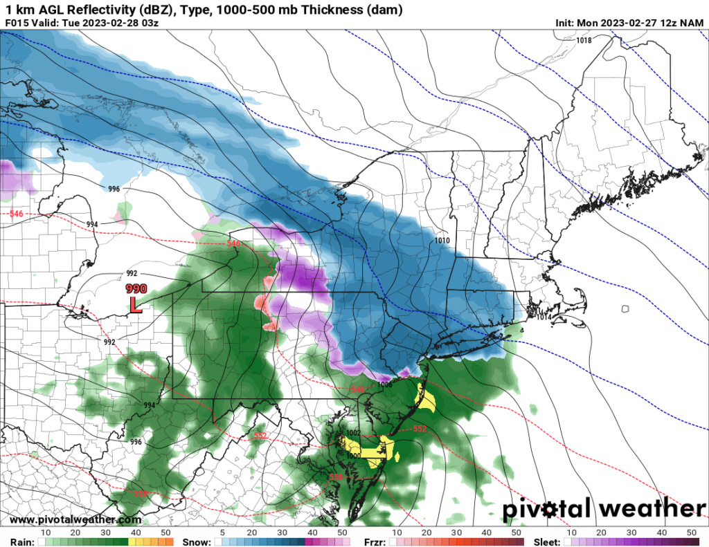
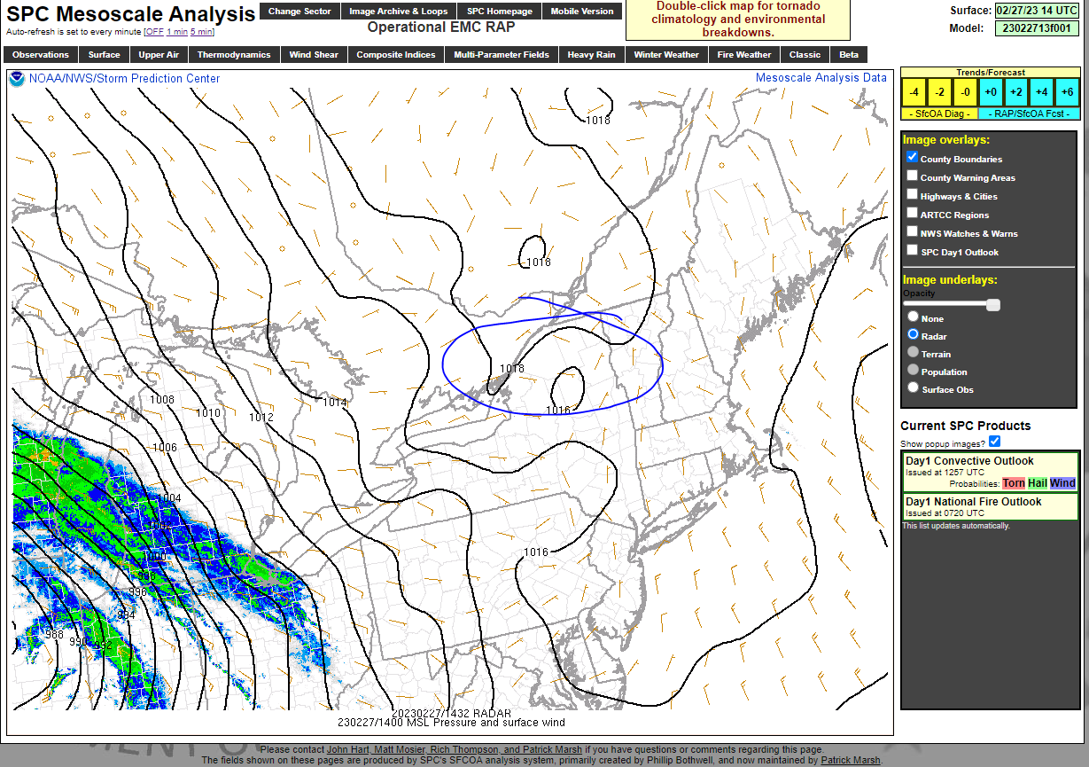
February 27th-28th 2023 Winter Storm
+31
Frozen.9
Math23x7
WeatherBob
CPcantmeasuresnow
crippo84
dkodgis
Zhukov1945
lglickman1
SENJsnowman
JT33
weatherwatchermom
essexcountypete
DAYBLAZER
1190ftalt
kalleg
Coachgriff
Dunnzoo
phil155
MattyICE
nutleyblizzard
aiannone
CNWestMilford
amugs
frank 638
sroc4
brownie
jmanley32
WinterColdandSnowisamyth
heehaw453
billg315
Frank_Wx
35 posters
Page 2 of 10
Page 2 of 10 •  1, 2, 3, 4, 5, 6, 7, 8, 9, 10
CNWestMilford- Posts : 43
Join date : 2020-12-15
CPcantmeasuresnow and kalleg like this post
 Re: February 27th-28th 2023 Winter Storm
The trend is definitely looking snowier for interior areas away from the coast. LOTS of moisture and higher snow rates will help lift snow amounts by a significant margin. Looks like I'll need to update my snow map later today.
CPcantmeasuresnow and kalleg like this post
 Re: February 27th-28th 2023 Winter Storm
Looks like snow may start as early as 6-7pm this evening. Heaviest snowfall between 10pm and 3am.
_________________
_______________________________________________________________________________________________________
CLICK HERE to view NJ Strong Snowstorm Classifications
heehaw453 likes this post
 Re: February 27th-28th 2023 Winter Storm
Frank_Wx wrote:The trend is definitely looking snowier for interior areas away from the coast. LOTS of moisture and higher snow rates will help lift snow amounts by a significant margin. Looks like I'll need to update my snow map later today.
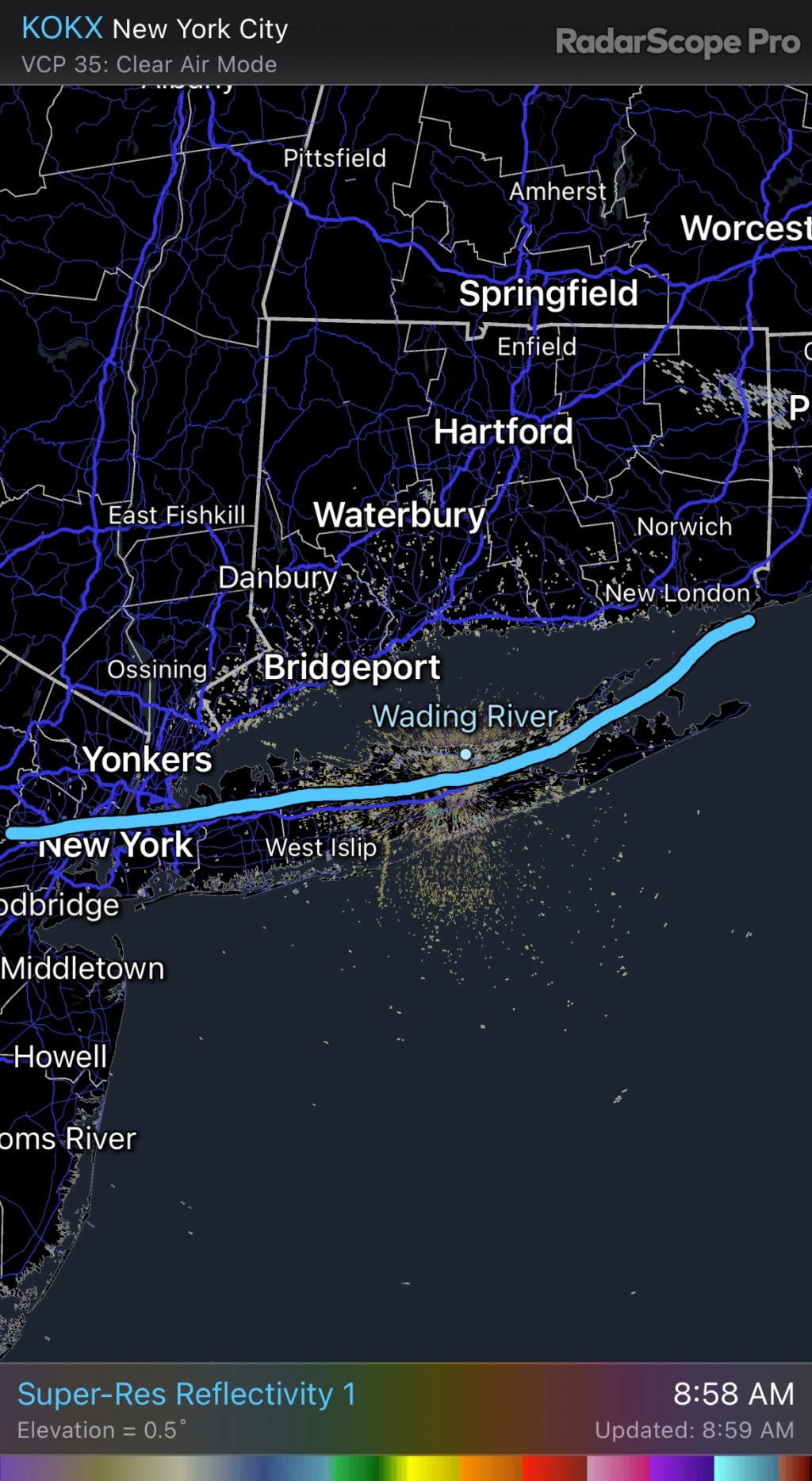
If you’re going to update keep in mind there is a battle ground that pretty much follows the LIE. Do not be surprised to see a swath along the north shore of 4-6” with this one. Personally I think it happens in NW Suffolk and Nassau. A general 2-4” for LI is reasonable elsewhere with areas south of the southern state parkway in the c-2” range.
This is the battle ground IMO.
_________________
"In weather and in life, there's no winning and losing; there's only winning and learning."
WINTER 2012/2013 TOTALS 43.65"WINTER 2017/2018 TOTALS 62.85" WINTER 2022/2023 TOTALS 4.9"
WINTER 2013/2014 TOTALS 64.85"WINTER 2018/2019 TOTALS 14.25" WINTER 2023/2024 TOTALS 13.1"
WINTER 2014/2015 TOTALS 71.20"WINTER 2019/2020 TOTALS 6.35"
WINTER 2015/2016 TOTALS 35.00"WINTER 2020/2021 TOTALS 37.75"
WINTER 2016/2017 TOTALS 42.25"WINTER 2021/2022 TOTALS 31.65"

sroc4- Admin

- Posts : 8354
Reputation : 302
Join date : 2013-01-07
Location : Wading River, LI
 Re: February 27th-28th 2023 Winter Storm
And also keep in mind a slight wobble of the 700/850 mb low and consolidation will have sig impacts on where it snows vs mixing. No model is going to nail that and it's a nowcast type of thing.
heehaw453- Advanced Forecaster

- Posts : 3906
Reputation : 86
Join date : 2014-01-20
Location : Bedminster Township, PA Elevation 600' ASL
weatherwatchermom likes this post
heehaw453- Advanced Forecaster

- Posts : 3906
Reputation : 86
Join date : 2014-01-20
Location : Bedminster Township, PA Elevation 600' ASL

aiannone- Senior Enthusiast - Mod

- Posts : 4815
Reputation : 92
Join date : 2013-01-07
Location : Saint James, LI (Northwest Suffolk Co.)
heehaw453 likes this post
 Re: February 27th-28th 2023 Winter Storm
NAM!!!!!!!
So much energy flying over LHV, NNJ, NYC METRO!
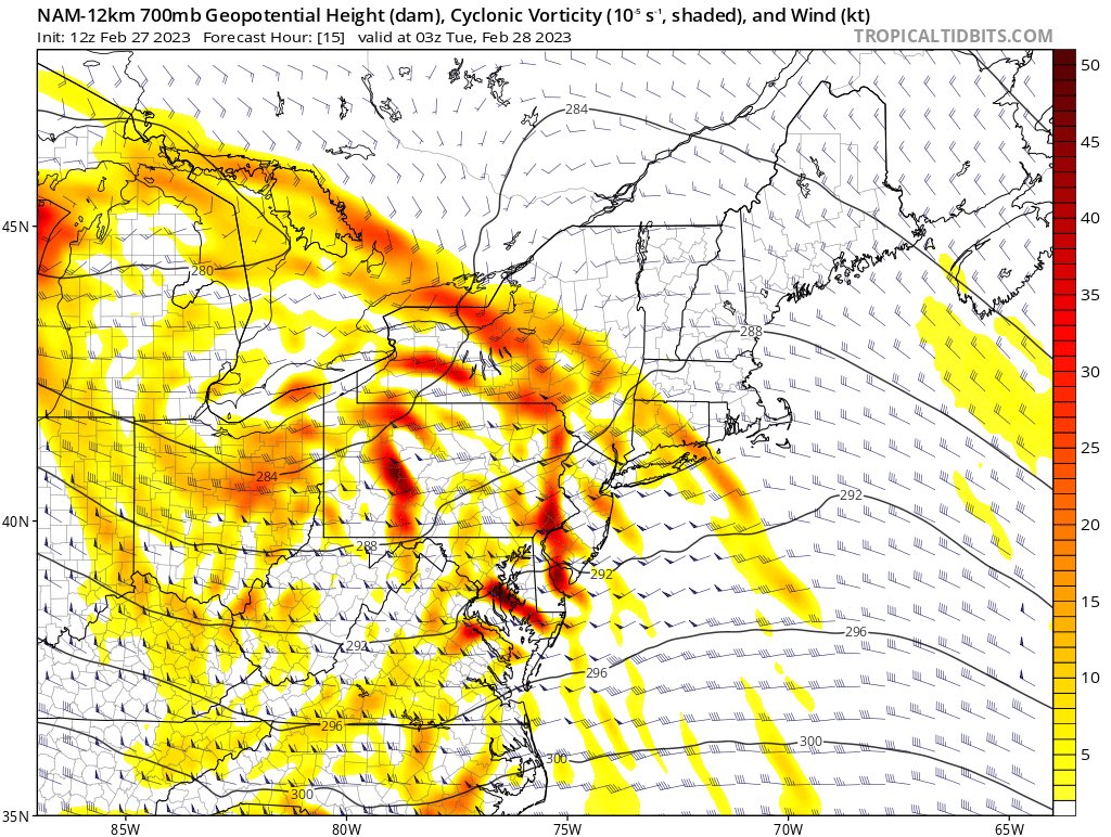
So much energy flying over LHV, NNJ, NYC METRO!

_________________
Mugs
AKA:King: Snow Weenie
Self Proclaimed
WINTER 2014-15 : 55.12" +.02 for 6 coatings (avg. 35")
WINTER 2015-16 Total - 29.8" (Avg 35")
WINTER 2016-17 : 39.5" so far

amugs- Advanced Forecaster - Mod

- Posts : 15095
Reputation : 213
Join date : 2013-01-07
Age : 54
Location : Hillsdale,NJ
 Re: February 27th-28th 2023 Winter Storm
RGEM from 33 n Rain Superstorm
The -5 Omega red circle and just around this area is where it will thump snow on the scale of 1-1.5" per hour.

The -5 Omega red circle and just around this area is where it will thump snow on the scale of 1-1.5" per hour.

_________________
Mugs
AKA:King: Snow Weenie
Self Proclaimed
WINTER 2014-15 : 55.12" +.02 for 6 coatings (avg. 35")
WINTER 2015-16 Total - 29.8" (Avg 35")
WINTER 2016-17 : 39.5" so far

amugs- Advanced Forecaster - Mod

- Posts : 15095
Reputation : 213
Join date : 2013-01-07
Age : 54
Location : Hillsdale,NJ
CPcantmeasuresnow and CNWestMilford like this post
 Re: February 27th-28th 2023 Winter Storm
heehaw453- Advanced Forecaster

- Posts : 3906
Reputation : 86
Join date : 2014-01-20
Location : Bedminster Township, PA Elevation 600' ASL
 Re: February 27th-28th 2023 Winter Storm
_________________
-Alex Iannone-

aiannone- Senior Enthusiast - Mod

- Posts : 4815
Reputation : 92
Join date : 2013-01-07
Location : Saint James, LI (Northwest Suffolk Co.)
amugs likes this post
 Re: February 27th-28th 2023 Winter Storm
HREF says hello


_________________
Mugs
AKA:King: Snow Weenie
Self Proclaimed
WINTER 2014-15 : 55.12" +.02 for 6 coatings (avg. 35")
WINTER 2015-16 Total - 29.8" (Avg 35")
WINTER 2016-17 : 39.5" so far

amugs- Advanced Forecaster - Mod

- Posts : 15095
Reputation : 213
Join date : 2013-01-07
Age : 54
Location : Hillsdale,NJ
 Re: February 27th-28th 2023 Winter Storm
GFS coming in more amped!

nutleyblizzard- Senior Enthusiast

- Posts : 1954
Reputation : 41
Join date : 2014-01-30
Age : 58
Location : Nutley, new jersey

nutleyblizzard- Senior Enthusiast

- Posts : 1954
Reputation : 41
Join date : 2014-01-30
Age : 58
Location : Nutley, new jersey
 Re: February 27th-28th 2023 Winter Storm
_________________
"In weather and in life, there's no winning and losing; there's only winning and learning."
WINTER 2012/2013 TOTALS 43.65"WINTER 2017/2018 TOTALS 62.85" WINTER 2022/2023 TOTALS 4.9"
WINTER 2013/2014 TOTALS 64.85"WINTER 2018/2019 TOTALS 14.25" WINTER 2023/2024 TOTALS 13.1"
WINTER 2014/2015 TOTALS 71.20"WINTER 2019/2020 TOTALS 6.35"
WINTER 2015/2016 TOTALS 35.00"WINTER 2020/2021 TOTALS 37.75"
WINTER 2016/2017 TOTALS 42.25"WINTER 2021/2022 TOTALS 31.65"

sroc4- Admin

- Posts : 8354
Reputation : 302
Join date : 2013-01-07
Location : Wading River, LI
 Re: February 27th-28th 2023 Winter Storm
With the 12z NAM coming around and the GFS and Euro largely holding serve, I'm feeling that my preliminary projection yesterday in the Obs Thread might just pan out. I'm not going to do a map, but here is what I posted yesterday and I think it still generally holds for now:
North of I-78 and all of LI: Mostly all snow with amounts in the 4-6" range.
North of I-195 (Trenton to Belmar) to I-78: Snow, mixing briefly in the middle with sleet/frz, before maybe ending as just snow with amounts in the 2-4" range.
South of I-195 (or the line from Trenton to just south of LI). A slushy inch or two of snow before mixing with sleet/frz, and then rain limiting any further accumulation.
I might alter that to say 2-4" along south shore of LI as opposed to 4-6" for all of LI and isolated 6-8" amounts for the more northern areas like the LHV.
The wild card here in that central (2-4) zone is the mixing factor. If you're in any area that doesn't mix, you'll almost certainly hit the high-end numbers, if you mix extensively you'll struggle to get to the low-ends.

billg315- Advanced Forecaster - Mod

- Posts : 4483
Reputation : 185
Join date : 2015-01-24
Age : 50
Location : Flemington, NJ
 Re: February 27th-28th 2023 Winter Storm
So being north of that line but about 50 miles or so (maybe more like 30) Am I in for the possible higher amount in your new map frank? When you say coastal areas I am never sure what exactly you mean, but this image is very helpful thanks scott. Still a margin that is near razor thin, hoping it can stay south of me and stay mainly snow.sroc4 wrote:Frank_Wx wrote:The trend is definitely looking snowier for interior areas away from the coast. LOTS of moisture and higher snow rates will help lift snow amounts by a significant margin. Looks like I'll need to update my snow map later today.
If you’re going to update keep in mind there is a battle ground that pretty much follows the LIE. Do not be surprised to see a swath along the north shore of 4-6” with this one. Personally I think it happens in NW Suffolk and Nassau. A general 2-4” for LI is reasonable elsewhere with areas south of the southern state parkway in the c-2” range.
This is the battle ground IMO.

jmanley32- Senior Enthusiast

- Posts : 20535
Reputation : 108
Join date : 2013-12-12
Age : 43
Location : Yonkers, NY

jmanley32- Senior Enthusiast

- Posts : 20535
Reputation : 108
Join date : 2013-12-12
Age : 43
Location : Yonkers, NY
 Re: February 27th-28th 2023 Winter Storm
Anybody who finds themself in the "middle zones" on some of the accumulation maps (i.e. 2-4") is going to have to seriously nowcast because the real range there is probably more like 2-6" because if there is a lot of mixing, you're gonna struggle to get more than 2", but if you stay mainly snow, you could definitely "overperform" in that zone with some of the snowfall rates we are expecting.

billg315- Advanced Forecaster - Mod

- Posts : 4483
Reputation : 185
Join date : 2015-01-24
Age : 50
Location : Flemington, NJ
sroc4 and kalleg like this post
heehaw453- Advanced Forecaster

- Posts : 3906
Reputation : 86
Join date : 2014-01-20
Location : Bedminster Township, PA Elevation 600' ASL
 Re: February 27th-28th 2023 Winter Storm
Agree on this. I'm up to 42* (albeit with a dewpoint of 23* which is the saving grace). I'm actually wondering if even some areas that go over to snow maybe even briefly start as rain because of these temps before the precipitation picks up. Or if we deal with virga for awhile due to the dry air.

billg315- Advanced Forecaster - Mod

- Posts : 4483
Reputation : 185
Join date : 2015-01-24
Age : 50
Location : Flemington, NJ
 Re: February 27th-28th 2023 Winter Storm
Here is a hypothesis that will need some digging into and maybe SROC can attest and aid with this:
Theer is a pretty long duration Geomagnetic Storm Event happening since last night
Theer is a pretty long duration Geomagnetic Storm Event happening since last night
_________________
Mugs
AKA:King: Snow Weenie
Self Proclaimed
WINTER 2014-15 : 55.12" +.02 for 6 coatings (avg. 35")
WINTER 2015-16 Total - 29.8" (Avg 35")
WINTER 2016-17 : 39.5" so far

amugs- Advanced Forecaster - Mod

- Posts : 15095
Reputation : 213
Join date : 2013-01-07
Age : 54
Location : Hillsdale,NJ
 Re: February 27th-28th 2023 Winter Storm
GFS 12Z says hi


_________________
Mugs
AKA:King: Snow Weenie
Self Proclaimed
WINTER 2014-15 : 55.12" +.02 for 6 coatings (avg. 35")
WINTER 2015-16 Total - 29.8" (Avg 35")
WINTER 2016-17 : 39.5" so far

amugs- Advanced Forecaster - Mod

- Posts : 15095
Reputation : 213
Join date : 2013-01-07
Age : 54
Location : Hillsdale,NJ
 Re: February 27th-28th 2023 Winter Storm
That's very possible. I was at 27.2 this morning here so ground was frozen, but certainly doesn't help my cause going into low 40s.billg315 wrote:
Agree on this. I'm up to 42* (albeit with a dewpoint of 23* which is the saving grace). I'm actually wondering if even some areas that go over to snow maybe even briefly start as rain because of these temps before the precipitation picks up. Or if we deal with virga for awhile due to the dry air.
heehaw453- Advanced Forecaster

- Posts : 3906
Reputation : 86
Join date : 2014-01-20
Location : Bedminster Township, PA Elevation 600' ASL
 Re: February 27th-28th 2023 Winter Storm
Some things I like to remind myself of as we get closer:
1) latent heat release. This storm is producing quite a bit of convection out in Illinois. This can pump things out ahead a little bit. We look for this factor when storms are modeled to far out to sea to try to nudge the system more N and W. No idea if this will come into play but could be a wildcard for fringe spots.
2) speed and duration. This likely comes in ahead of schedule and lasts more quickly than we think it might and ends quicker. Think of how many times one model or another made it look like it would precipitate hours longer than it ended up. I think any appreciable accumulating snows are done by daybreak.
3) what falls from the sky may not be what accumulates. 6 inches could fall. But how much melts initially. How much gets compacted with snow that is more wet than powdery and does qpf get wasted on sleet? All of that can result in 2.5 inches of slush and yet a 3-6 call would have still been accurate
There’s probably more but regardless many their first real snow tonight! I do think from 80ish on north is going to end up doing quite well.
MattyICE- Advanced Forecaster

- Posts : 249
Reputation : 6
Join date : 2017-11-10
Age : 38
Location : Clifton, NJ (Eastern Passaic County)
Frank_Wx, kalleg and billg315 like this post
 Re: February 27th-28th 2023 Winter Storm
MattyICE wrote:Some things I like to remind myself of as we get closer:
1) latent heat release. This storm is producing quite a bit of convection out in Illinois. This can pump things out ahead a little bit. We look for this factor when storms are modeled to far out to sea to try to nudge the system more N and W. No idea if this will come into play but could be a wildcard for fringe spots.
2) speed and duration. This likely comes in ahead of schedule and lasts more quickly than we think it might and ends quicker. Think of how many times one model or another made it look like it would precipitate hours longer than it ended up. I think any appreciable accumulating snows are done by daybreak.
3) what falls from the sky may not be what accumulates. 6 inches could fall. But how much melts initially. How much gets compacted with snow that is more wet than powdery and does qpf get wasted on sleet? All of that can result in 2.5 inches of slush and yet a 3-6 call would have still been accurate
There’s probably more but regardless many their first real snow tonight! I do think from 80ish on north is going to end up doing quite well.
#2 is a persistent pet peeve of mine. Models love to indicate long, drawn out events that in reality end much more abruptly once the storms begin to accelerate northeast.

billg315- Advanced Forecaster - Mod

- Posts : 4483
Reputation : 185
Join date : 2015-01-24
Age : 50
Location : Flemington, NJ
docstox12, kalleg, essexcountypete, MattyICE and WinterColdandSnowisamyth like this post
 Re: February 27th-28th 2023 Winter Storm
amugs wrote:GFS 12Z says hi
Not a fan of the GFSin the short term, or even the long term the last couple of years.
As shown there NYC straddles the change line and seems to snow heavy snow, at least from Central Park north, almost throughout. That could surprise many total wise if it happened as depicted. I would tend to think it won’t happen quite as intensely as depicted there.
WinterColdandSnowisamyth- Posts : 23
Reputation : 0
Join date : 2023-02-26
Page 2 of 10 •  1, 2, 3, 4, 5, 6, 7, 8, 9, 10
Page 2 of 10
Permissions in this forum:
You cannot reply to topics in this forum|
|
|

 Home
Home