
 Search
February 27th-28th 2023 Winter Storm
Page 3 of 10 •  1, 2, 3, 4, 5, 6, 7, 8, 9, 10
 ![]()
Re: February 27th-28th 2023 Winter Storm
![]() by billg315 Mon Feb 27, 2023 12:17 pm
by billg315 Mon Feb 27, 2023 12:17 pm
MattyICE wrote:Some things I like to remind myself of as we get closer:
1) latent heat release. This storm is producing quite a bit of convection out in Illinois. This can pump things out ahead a little bit. We look for this factor when storms are modeled to far out to sea to try to nudge the system more N and W. No idea if this will come into play but could be a wildcard for fringe spots.
2) speed and duration. This likely comes in ahead of schedule and lasts more quickly than we think it might and ends quicker. Think of how many times one model or another made it look like it would precipitate hours longer than it ended up. I think any appreciable accumulating snows are done by daybreak.
3) what falls from the sky may not be what accumulates. 6 inches could fall. But how much melts initially. How much gets compacted with snow that is more wet than powdery and does qpf get wasted on sleet? All of that can result in 2.5 inches of slush and yet a 3-6 call would have still been accurate
There’s probably more but regardless many their first real snow tonight! I do think from 80ish on north is going to end up doing quite well.
#2 is a persistent pet peeve of mine. Models love to indicate long, drawn out events that in reality end much more abruptly once the storms begin to accelerate northeast.
billg315- Advanced Forecaster - Mod

- Posts : 4483
Join date : 2015-01-24
docstox12, kalleg, essexcountypete, MattyICE and WinterColdandSnowisamyth like this post
Re: February 27th-28th 2023 Winter Storm
![]() by WinterColdandSnowisamyth Mon Feb 27, 2023 12:23 pm
by WinterColdandSnowisamyth Mon Feb 27, 2023 12:23 pm
amugs wrote:GFS 12Z says hi

Not a fan of the GFSin the short term, or even the long term the last couple of years.
As shown there NYC straddles the change line and seems to snow heavy snow, at least from Central Park north, almost throughout. That could surprise many total wise if it happened as depicted. I would tend to think it won’t happen quite as intensely as depicted there.
WinterColdandSnowisamyth- Posts : 23
Join date : 2023-02-26
Re: February 27th-28th 2023 Winter Storm
![]() by sroc4 Mon Feb 27, 2023 12:25 pm
by sroc4 Mon Feb 27, 2023 12:25 pm
billg315 wrote:MattyICE wrote:Some things I like to remind myself of as we get closer:
1) latent heat release. This storm is producing quite a bit of convection out in Illinois. This can pump things out ahead a little bit. We look for this factor when storms are modeled to far out to sea to try to nudge the system more N and W. No idea if this will come into play but could be a wildcard for fringe spots.
2) speed and duration. This likely comes in ahead of schedule and lasts more quickly than we think it might and ends quicker. Think of how many times one model or another made it look like it would precipitate hours longer than it ended up. I think any appreciable accumulating snows are done by daybreak.
3) what falls from the sky may not be what accumulates. 6 inches could fall. But how much melts initially. How much gets compacted with snow that is more wet than powdery and does qpf get wasted on sleet? All of that can result in 2.5 inches of slush and yet a 3-6 call would have still been accurate
There’s probably more but regardless many their first real snow tonight! I do think from 80ish on north is going to end up doing quite well.
#2 is a persistent pet peeve of mine. Models love to indicate long, drawn out events that in reality end much more abruptly once the storms begin to accelerate northeast.
Except this storms trajectory is ESE; not NE. Same difference though. It almost always begins at or earlier than modeled and def finishes earlier
_________________
"In weather and in life, there's no winning and losing; there's only winning and learning."
WINTER 2012/2013 TOTALS 43.65"WINTER 2017/2018 TOTALS 62.85" WINTER 2022/2023 TOTALS 4.9"
WINTER 2013/2014 TOTALS 64.85"WINTER 2018/2019 TOTALS 14.25" WINTER 2023/2024 TOTALS 13.1"
WINTER 2014/2015 TOTALS 71.20"WINTER 2019/2020 TOTALS 6.35"
WINTER 2015/2016 TOTALS 35.00"WINTER 2020/2021 TOTALS 37.75"
WINTER 2016/2017 TOTALS 42.25"WINTER 2021/2022 TOTALS 31.65"

sroc4- Admin

- Posts : 8354
Reputation : 302
Join date : 2013-01-07
Location : Wading River, LI
MattyICE likes this post
Re: February 27th-28th 2023 Winter Storm
![]() by WinterColdandSnowisamyth Mon Feb 27, 2023 12:27 pm
by WinterColdandSnowisamyth Mon Feb 27, 2023 12:27 pm
MattyICE wrote:Some things I like to remind myself of as we get closer:
1) latent heat release. This storm is producing quite a bit of convection out in Illinois. This can pump things out ahead a little bit. We look for this factor when storms are modeled to far out to sea to try to nudge the system more N and W. No idea if this will come into play but could be a wildcard for fringe spots.
2) speed and duration. This likely comes in ahead of schedule and lasts more quickly than we think it might and ends quicker. Think of how many times one model or another made it look like it would precipitate hours longer than it ended up. I think any appreciable accumulating snows are done by daybreak.
3) what falls from the sky may not be what accumulates. 6 inches could fall. But how much melts initially. How much gets compacted with snow that is more wet than powdery and does qpf get wasted on sleet? All of that can result in 2.5 inches of slush and yet a 3-6 call would have still been accurate
There’s probably more but regardless many their first real snow tonight! I do think from 80ish on north is going to end up doing quite well.
I had written something very similar earlier today, along the lines of in the northern areas where 8 to 10 inches is predicted they are much more likely to end up with that on the ground. The border line areas where 3 to 5 inches are predicted may I actually see 4 inches at the beginning of the storm and end up with nothing or an inch of slush on the ground when it ends. Technically the Maps are correct but the sledders are left with nothing to show for it.
WinterColdandSnowisamyth- Posts : 23
Reputation : 0
Join date : 2023-02-26
kalleg and MattyICE like this post
Re: February 27th-28th 2023 Winter Storm
![]() by phil155 Mon Feb 27, 2023 12:32 pm
by phil155 Mon Feb 27, 2023 12:32 pm
phil155- Pro Enthusiast

- Posts : 483
Reputation : 4
Join date : 2019-12-16
Re: February 27th-28th 2023 Winter Storm
![]() by heehaw453 Mon Feb 27, 2023 12:55 pm
by heehaw453 Mon Feb 27, 2023 12:55 pm
I have to agree. I'm at 43.5. I think it will affect accumulations. I'm seeing 40's right into NW NJ and LHV currently. Wet bulb will occur, but the fact of the matter is the antecedent ground is warm.phil155 wrote:at 46 degrees here in edison, seems a bit too warm
heehaw453- Advanced Forecaster

- Posts : 3906
Reputation : 86
Join date : 2014-01-20
Location : Bedminster Township, PA Elevation 600' ASL
Re: February 27th-28th 2023 Winter Storm
![]() by sroc4 Mon Feb 27, 2023 12:55 pm
by sroc4 Mon Feb 27, 2023 12:55 pm
_________________
"In weather and in life, there's no winning and losing; there's only winning and learning."
WINTER 2012/2013 TOTALS 43.65"WINTER 2017/2018 TOTALS 62.85" WINTER 2022/2023 TOTALS 4.9"
WINTER 2013/2014 TOTALS 64.85"WINTER 2018/2019 TOTALS 14.25" WINTER 2023/2024 TOTALS 13.1"
WINTER 2014/2015 TOTALS 71.20"WINTER 2019/2020 TOTALS 6.35"
WINTER 2015/2016 TOTALS 35.00"WINTER 2020/2021 TOTALS 37.75"
WINTER 2016/2017 TOTALS 42.25"WINTER 2021/2022 TOTALS 31.65"
sroc4- Admin
- Posts : 8354
Reputation : 302
Join date : 2013-01-07
Location : Wading River, LI
Re: February 27th-28th 2023 Winter Storm
![]() by heehaw453 Mon Feb 27, 2023 1:13 pm
by heehaw453 Mon Feb 27, 2023 1:13 pm
First pic is current temps and second are current wet bulb temps. Sroc land is probably getting winds off LI Sound to keep it cooler.


heehaw453- Advanced Forecaster
- Posts : 3906
Reputation : 86
Join date : 2014-01-20
Location : Bedminster Township, PA Elevation 600' ASL
Re: February 27th-28th 2023 Winter Storm
![]() by jmanley32 Mon Feb 27, 2023 1:18 pm
by jmanley32 Mon Feb 27, 2023 1:18 pm

jmanley32- Senior Enthusiast

- Posts : 20535
Reputation : 108
Join date : 2013-12-12
Age : 43
Location : Yonkers, NY
Re: February 27th-28th 2023 Winter Storm
![]() by heehaw453 Mon Feb 27, 2023 1:23 pm
by heehaw453 Mon Feb 27, 2023 1:23 pm
I'm at 43.5 Lol.jmanley32 wrote:Yeah way to warm here, gonna be hard to stick.
heehaw453- Advanced Forecaster
- Posts : 3906
Reputation : 86
Join date : 2014-01-20
Location : Bedminster Township, PA Elevation 600' ASL
Re: February 27th-28th 2023 Winter Storm
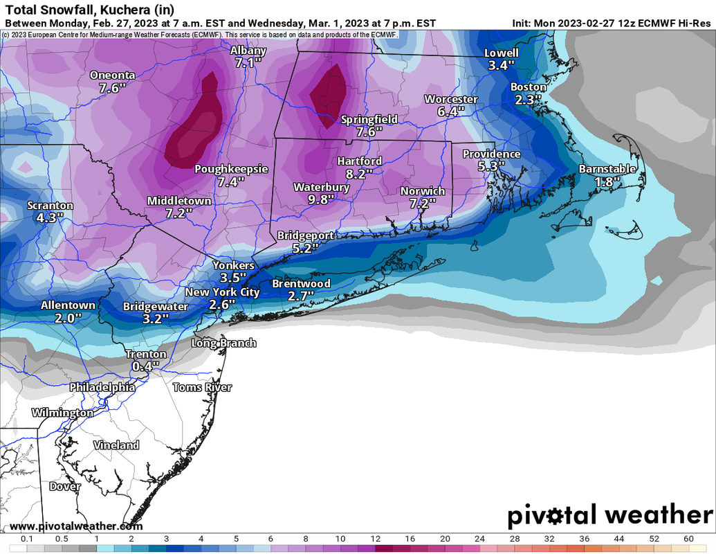
![]() by Frank_Wx Mon Feb 27, 2023 1:28 pm
by Frank_Wx Mon Feb 27, 2023 1:28 pm
Here is the 12z EURO Kuchera snowfall map
_________________
_______________________________________________________________________________________________________
CLICK HERE to view NJ Strong Snowstorm Classifications

Frank_Wx- Godzilla Seeker
- Posts : 21305
Reputation : 328
Join date : 2013-01-05
Age : 32
Location : Jersey City, NJ -

WinterColdandSnowisamyth likes this post
Re: February 27th-28th 2023 Winter Storm
![]() by Dunnzoo Mon Feb 27, 2023 1:28 pm
by Dunnzoo Mon Feb 27, 2023 1:28 pm
_________________
Janet
Snowfall winter of 2023-2024 17.5"
Snowfall winter of 2022-2023 6.0"
Snowfall winter of 2021-2022 17.6" 1" sleet 2/25/22
Snowfall winter of 2020-2021 51.1"
Snowfall winter of 2019-2020 8.5"
Snowfall winter of 2018-2019 25.1"
Snowfall winter of 2017-2018 51.9"
Snowfall winter of 2016-2017 45.6"
Snowfall winter of 2015-2016 29.5"
Snowfall winter of 2014-2015 50.55"
Snowfall winter of 2013-2014 66.5"

Dunnzoo- Senior Enthusiast - Mod
- Posts : 4905
Reputation : 68
Join date : 2013-01-11
Age : 62
Location : Westwood, NJ
Re: February 27th-28th 2023 Winter Storm
![]() by phil155 Mon Feb 27, 2023 1:31 pm
by phil155 Mon Feb 27, 2023 1:31 pm
phil155- Pro Enthusiast
- Posts : 483
Reputation : 4
Join date : 2019-12-16
Re: February 27th-28th 2023 Winter Storm
![]() by sroc4 Mon Feb 27, 2023 1:36 pm
by sroc4 Mon Feb 27, 2023 1:36 pm


_________________
"In weather and in life, there's no winning and losing; there's only winning and learning."
WINTER 2012/2013 TOTALS 43.65"WINTER 2017/2018 TOTALS 62.85" WINTER 2022/2023 TOTALS 4.9"
WINTER 2013/2014 TOTALS 64.85"WINTER 2018/2019 TOTALS 14.25" WINTER 2023/2024 TOTALS 13.1"
WINTER 2014/2015 TOTALS 71.20"WINTER 2019/2020 TOTALS 6.35"
WINTER 2015/2016 TOTALS 35.00"WINTER 2020/2021 TOTALS 37.75"
WINTER 2016/2017 TOTALS 42.25"WINTER 2021/2022 TOTALS 31.65"
sroc4- Admin
- Posts : 8354
Reputation : 302
Join date : 2013-01-07
Location : Wading River, LI
Re: February 27th-28th 2023 Winter Storm
![]() by CNWestMilford Mon Feb 27, 2023 1:38 pm
by CNWestMilford Mon Feb 27, 2023 1:38 pm
Frank_Wx wrote:I removed the censorship that was placed on the word Kuchera. I read that modifications and improvements have been made with the logic, and this storm may be a good test to see how it performs considering surface temps are above freezing for many along the coast. If it fails me again, I am putting the censorship back on!
Here is the 12z EURO Kuchera snowfall map
Once again another increase and more widespread accumulations from 0z.

CNWestMilford- Posts : 43
Reputation : 1
Join date : 2020-12-15
Age : 47
Location : West Milford
Re: February 27th-28th 2023 Winter Storm
![]() by heehaw453 Mon Feb 27, 2023 1:43 pm
by heehaw453 Mon Feb 27, 2023 1:43 pm

heehaw453- Advanced Forecaster
- Posts : 3906
Reputation : 86
Join date : 2014-01-20
Location : Bedminster Township, PA Elevation 600' ASL
Re: February 27th-28th 2023 Winter Storm
![]() by jmanley32 Mon Feb 27, 2023 1:45 pm
by jmanley32 Mon Feb 27, 2023 1:45 pm
However a drastic decrease IMBY according to that map, so i am going with 1-10 inches depending on which model you look at lol, and the fact if it changes to rain I may see nothing in the morning. And ouch the sledding comment, that's my girl give her a break she deserves it after 2 years without.CNWestMilford wrote:Frank_Wx wrote:I removed the censorship that was placed on the word Kuchera. I read that modifications and improvements have been made with the logic, and this storm may be a good test to see how it performs considering surface temps are above freezing for many along the coast. If it fails me again, I am putting the censorship back on!
Here is the 12z EURO Kuchera snowfall map
Once again another increase and more widespread accumulations from 0z.
jmanley32- Senior Enthusiast
- Posts : 20535
Reputation : 108
Join date : 2013-12-12
Age : 43
Location : Yonkers, NY
Re: February 27th-28th 2023 Winter Storm
![]() by heehaw453 Mon Feb 27, 2023 1:47 pm
by heehaw453 Mon Feb 27, 2023 1:47 pm
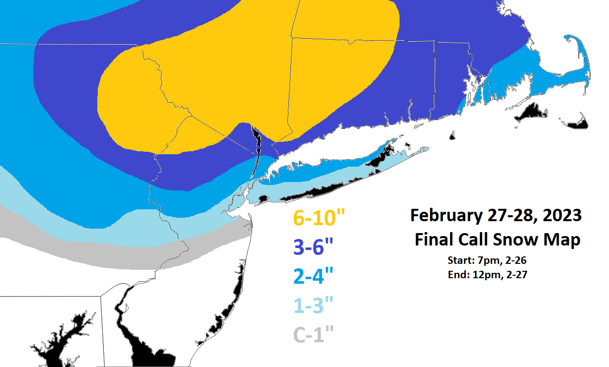
Sroc this is about accumulations really. It will snow I have no doubt, but what I think is push comes to shove the snow depth algorithm is best for this event, not kuchera or 10:1. This is what I believe reality holds for this event.sroc4 wrote:Dont panick too much yet folks. Here is the surface temps valid as of 2pm and then again by 7pm. Temps will drop again. Its all part of the plan. The details as to why I have been referring to the Kuchera maps is because the coastal plain will not likely see great ratios due to these marginal temps. You just cant look at the 10:1 maps. The latest Kuchera upgrades have def done much better this season. Again I know we all want 6+ but its not likely to be the norm along the coastal plain. IMHO. There will be however areas to over perform as well as underperform....happens every storm

heehaw453- Advanced Forecaster
- Posts : 3906
Reputation : 86
Join date : 2014-01-20
Location : Bedminster Township, PA Elevation 600' ASL
Re: February 27th-28th 2023 Winter Storm
![]() by Coachgriff Mon Feb 27, 2023 1:49 pm
by Coachgriff Mon Feb 27, 2023 1:49 pm
Coachgriff- Posts : 57
Reputation : 0
Join date : 2022-01-29
Re: February 27th-28th 2023 Winter Storm
![]() by WinterColdandSnowisamyth Mon Feb 27, 2023 1:52 pm
by WinterColdandSnowisamyth Mon Feb 27, 2023 1:52 pm
Frank_Wx wrote:I removed the censorship that was placed on the word Kuchera. I read that modifications and improvements have been made with the logic, and this storm may be a good test to see how it performs considering surface temps are above freezing for many along the coast. If it fails me again, I am putting the censorship back on!
Here is the 12z EURO Kuchera snowfall map
Probably the most realistic map I’ve seen today.
WinterColdandSnowisamyth- Posts : 23
Reputation : 0
Join date : 2023-02-26
phil155 likes this post
Re: February 27th-28th 2023 Winter Storm
![]() by CNWestMilford Mon Feb 27, 2023 1:58 pm
by CNWestMilford Mon Feb 27, 2023 1:58 pm
jmanley32 wrote:However a drastic decrease IMBY according to that map, so i am going with 1-10 inches depending on which model you look at lol, and the fact if it changes to rain I may see nothing in the morning. And ouch the sledding comment, that's my girl give her a break she deserves it after 2 years without.CNWestMilford wrote:Frank_Wx wrote:I removed the censorship that was placed on the word Kuchera. I read that modifications and improvements have been made with the logic, and this storm may be a good test to see how it performs considering surface temps are above freezing for many along the coast. If it fails me again, I am putting the censorship back on!
Here is the 12z EURO Kuchera snowfall map
Once again another increase and more widespread accumulations from 0z.
12z above …0z below.


CNWestMilford- Posts : 43
Reputation : 1
Join date : 2020-12-15
Age : 47
Location : West Milford
Re: February 27th-28th 2023 Winter Storm
![]() by Frank_Wx Mon Feb 27, 2023 1:59 pm
by Frank_Wx Mon Feb 27, 2023 1:59 pm
I think @WinterColdandSnowisamyth made the point earlier today that 5" of snow could theoretically fall, but how much sticks and how much ends up being washed away from rain? GFS seems like an outlier right now with its massive totals over a widespread area. A combo of the NAM and EURO is probably a more realistic picture.
_________________
_______________________________________________________________________________________________________
CLICK HERE to view NJ Strong Snowstorm Classifications
Frank_Wx- Godzilla Seeker
- Posts : 21305
Reputation : 328
Join date : 2013-01-05
Age : 32
Location : Jersey City, NJ -
sroc4, heehaw453, billg315, MattyICE, CNWestMilford, Coachgriff and WinterColdandSnowisamyth like this post
Re: February 27th-28th 2023 Winter Storm
![]() by billg315 Mon Feb 27, 2023 2:14 pm
by billg315 Mon Feb 27, 2023 2:14 pm

billg315- Advanced Forecaster - Mod
- Posts : 4483
Reputation : 185
Join date : 2015-01-24
Age : 50
Location : Flemington, NJ
Re: February 27th-28th 2023 Winter Storm
![]() by WinterColdandSnowisamyth Mon Feb 27, 2023 2:19 pm
by WinterColdandSnowisamyth Mon Feb 27, 2023 2:19 pm
heehaw453 wrote:Sroc this is about accumulations really. It will snow I have no doubt, but what I think is push comes to shove the snow depth algorithm is best for this event, not kuchera or 10:1. This is what I believe reality holds for this event.sroc4 wrote:Dont panick too much yet folks. Here is the surface temps valid as of 2pm and then again by 7pm. Temps will drop again. Its all part of the plan. The details as to why I have been referring to the Kuchera maps is because the coastal plain will not likely see great ratios due to these marginal temps. You just cant look at the 10:1 maps. The latest Kuchera upgrades have def done much better this season. Again I know we all want 6+ but its not likely to be the norm along the coastal plain. IMHO. There will be however areas to over perform as well as underperform....happens every storm
Nope, this one goes to far to the downside especially for the northern areas. I still stick with the Kuchera map that Frank posted a little while ago. Seemed very reasonable with amounts from north to south.
WinterColdandSnowisamyth- Posts : 23
Reputation : 0
Join date : 2023-02-26
Re: February 27th-28th 2023 Winter Storm
![]() by sroc4 Mon Feb 27, 2023 2:27 pm
by sroc4 Mon Feb 27, 2023 2:27 pm
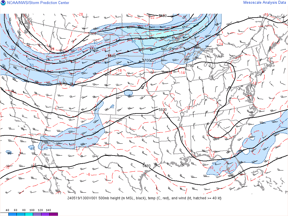
heehaw453 wrote:I'm watching this ULL. If it doesn't open up in the next hour or two it will have big impacts on the bad side for us.
The fact that we are even discussing accumulating snow with such a zonal flow across 97% of the CONUS is a bonus. In reality we shouldnt snow with this look at 500.
_________________
"In weather and in life, there's no winning and losing; there's only winning and learning."
WINTER 2012/2013 TOTALS 43.65"WINTER 2017/2018 TOTALS 62.85" WINTER 2022/2023 TOTALS 4.9"
WINTER 2013/2014 TOTALS 64.85"WINTER 2018/2019 TOTALS 14.25" WINTER 2023/2024 TOTALS 13.1"
WINTER 2014/2015 TOTALS 71.20"WINTER 2019/2020 TOTALS 6.35"
WINTER 2015/2016 TOTALS 35.00"WINTER 2020/2021 TOTALS 37.75"
WINTER 2016/2017 TOTALS 42.25"WINTER 2021/2022 TOTALS 31.65"
sroc4- Admin
- Posts : 8354
Reputation : 302
Join date : 2013-01-07
Location : Wading River, LI
heehaw453 likes this post
Re: February 27th-28th 2023 Winter Storm
![]() by heehaw453 Mon Feb 27, 2023 2:48 pm
by heehaw453 Mon Feb 27, 2023 2:48 pm
We'll see. The GFS one backs it up too for the northern area and I have found it very good at these marginal temp events. I think it's reasonable to see ASL locales > 1200' get 6" +, but lower elevations I'm not so sure.WinterColdandSnowisamyth wrote:heehaw453 wrote:Sroc this is about accumulations really. It will snow I have no doubt, but what I think is push comes to shove the snow depth algorithm is best for this event, not kuchera or 10:1. This is what I believe reality holds for this event.sroc4 wrote:Dont panick too much yet folks. Here is the surface temps valid as of 2pm and then again by 7pm. Temps will drop again. Its all part of the plan. The details as to why I have been referring to the Kuchera maps is because the coastal plain will not likely see great ratios due to these marginal temps. You just cant look at the 10:1 maps. The latest Kuchera upgrades have def done much better this season. Again I know we all want 6+ but its not likely to be the norm along the coastal plain. IMHO. There will be however areas to over perform as well as underperform....happens every storm
Nope, this one goes to far to the downside especially for the northern areas. I still stick with the Kuchera map that Frank posted a little while ago. Seemed very reasonable with amounts from north to south.

heehaw453- Advanced Forecaster
- Posts : 3906
Reputation : 86
Join date : 2014-01-20
Location : Bedminster Township, PA Elevation 600' ASL
Re: February 27th-28th 2023 Winter Storm
![]() by sroc4 Mon Feb 27, 2023 2:51 pm
by sroc4 Mon Feb 27, 2023 2:51 pm
_________________
"In weather and in life, there's no winning and losing; there's only winning and learning."
WINTER 2012/2013 TOTALS 43.65"WINTER 2017/2018 TOTALS 62.85" WINTER 2022/2023 TOTALS 4.9"
WINTER 2013/2014 TOTALS 64.85"WINTER 2018/2019 TOTALS 14.25" WINTER 2023/2024 TOTALS 13.1"
WINTER 2014/2015 TOTALS 71.20"WINTER 2019/2020 TOTALS 6.35"
WINTER 2015/2016 TOTALS 35.00"WINTER 2020/2021 TOTALS 37.75"
WINTER 2016/2017 TOTALS 42.25"WINTER 2021/2022 TOTALS 31.65"
sroc4- Admin
- Posts : 8354
Reputation : 302
Join date : 2013-01-07
Location : Wading River, LI
Page 3 of 10 • 1, 2, 3, 4, 5, 6, 7, 8, 9, 10 ![]()
|
|
|