March 13th-14th 2023 Big Dog Potential
+22
SENJsnowman
weatherwatchermom
essexcountypete
Dunnzoo
aiannone
MattyICE
CPcantmeasuresnow
CNWestMilford
phil155
lglickman1
hyde345
Frank_Wx
nutleyblizzard
amugs
docstox12
Carvin
jmanley32
dkodgis
Coachgriff
Quietace
heehaw453
sroc4
26 posters
Page 1 of 10
Page 1 of 10 • 1, 2, 3, 4, 5, 6, 7, 8, 9, 10 
 March 13th-14th 2023 Big Dog Potential
You know what...Im starting a thread for this one. Its not really long range anymore. It's really only 3-3.5days out now.
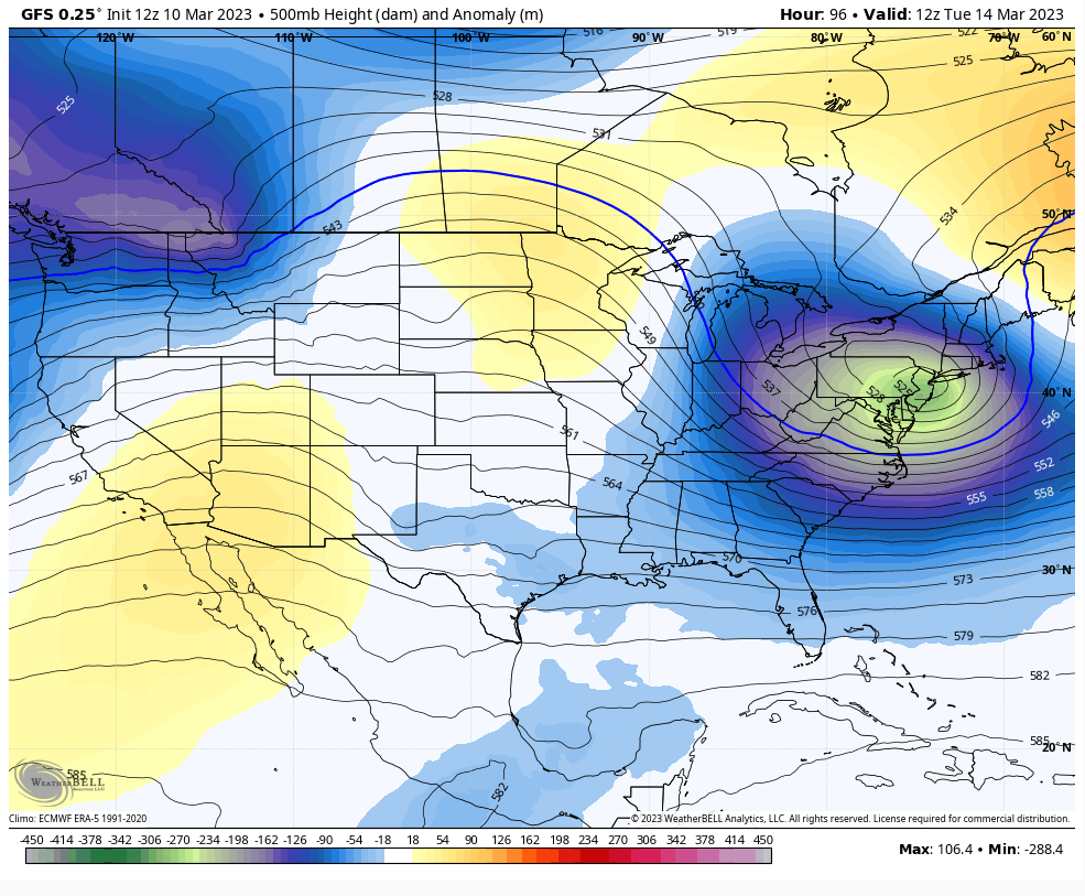
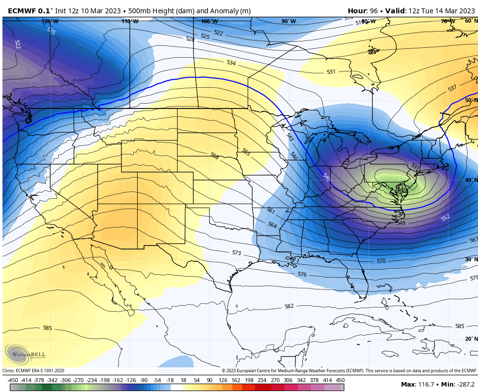
Morning. Quick update. Biggest difference between GFS and Euro basically comes down to how they are handling the western ridge.
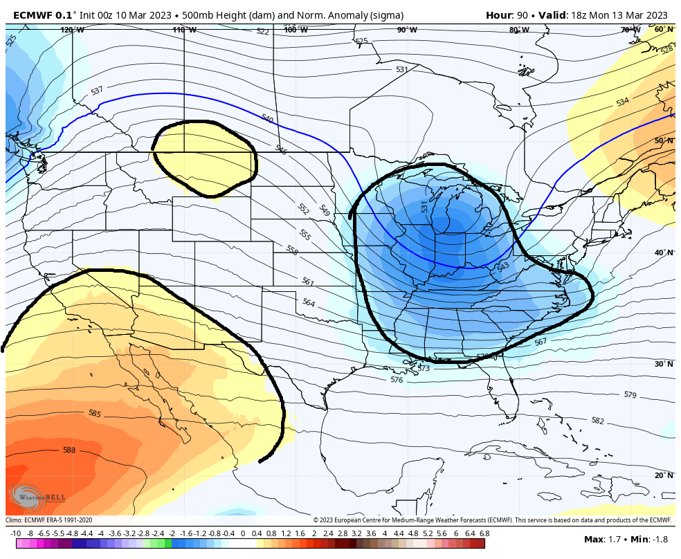
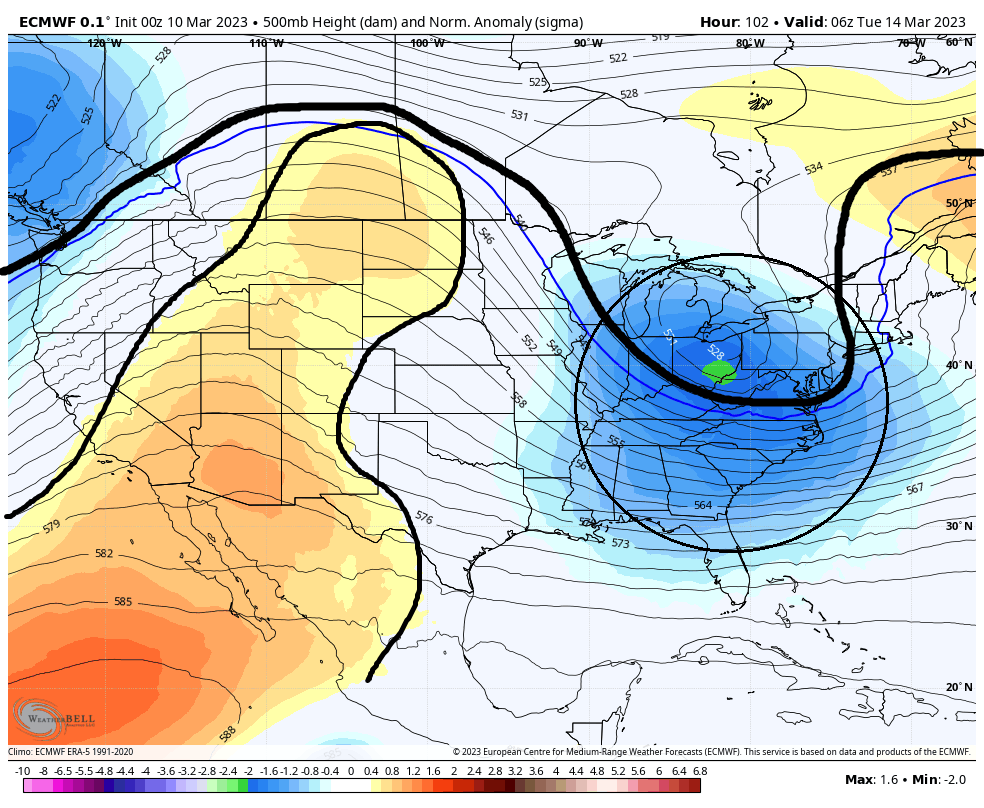
Below is the 500mb height anomaly maps representing 2pmMonday. Notice the difference in the strength of the oranges in the S west between GFS and Euro. Also notice the little circle of Orange on the euro vs GFS does not have it over Montana. What this tell me is that by Monday 2pm euro is building a western ridge and the GFS is not. And start to pay attention to the blue circled in the eastern third of the CONUS. This is our mean trough.

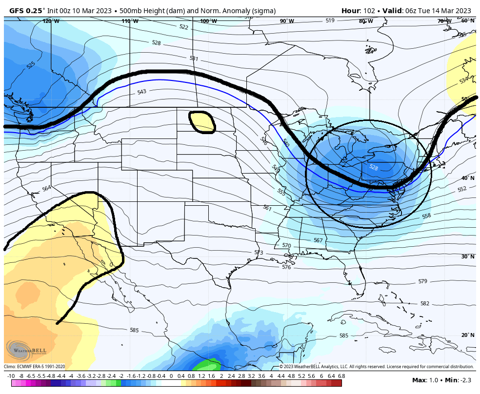
Fast forward approx 12hrs to 2am Tuesday. Now take notice how the GFS is just beginning to develop some orange in the northern tear of the CONUS whereas, the euro is now trying to connect the warm colors in the SW and N. Again this signifies a much more robust ridge to our west. The direct consequence of the more robust ridge is the blues much darker and deeper into the S&E
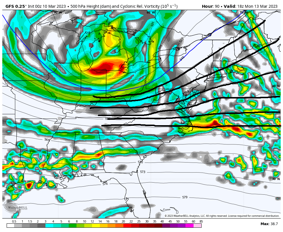
Going back to 2pm Monday maps lets look at the vorticity maps at 500mb. The result of a weaker vs stronger ridge out west means the difference between no phasing and weaker S energy with flatter 500mb heights along the EC, and losing some of the S energy OTS VS phasing, stronger S energy that raises heights along the EC drawing that energy up the coast.

Looking at the surface map the differences between no phasing and phasing at 500mb is a much weaker slp exiting the EC much further S headed ENE to NE (GFS) because of the progressive flow and positive to neutral trough tilt VS a much stronger slp exiting the EC further N with a trajectory to the NE to NNE because its being pulled in by the phased system that has a negative tilted trough.
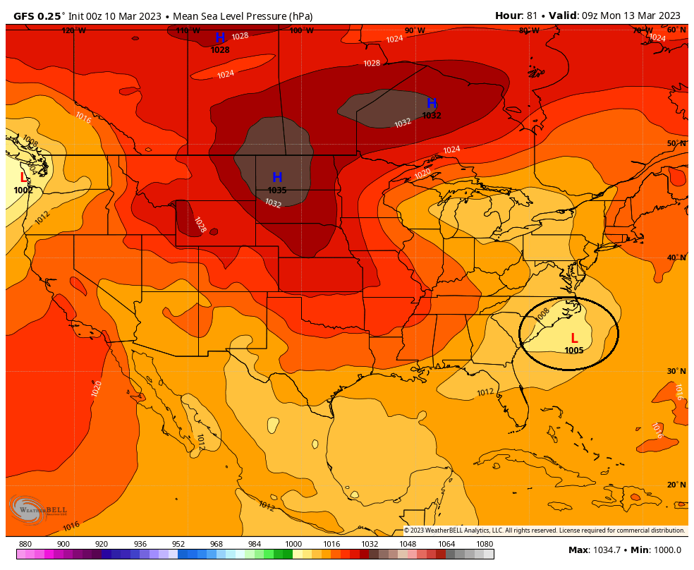

So again to summarize I think both GFS and Euro have the N Atlantic blocked up indicating eventually there will be a phase. But currently the GFS has a weaker trough development to the west so the mean trough cannot dig early enough resulting in a phase that ends up being a little late and overall less impactful system. However, the euro builds a more robust ridge in the west which results in a mean trough that digs earlier phasing the N and S energy early enough to develop a much more robust slp bringing it up the coast as a potent and rapidly deepening system that will be very impactful system one way or another. Details for the our coverage area is still way up in the air so please for the love of all that is holy do not ask if you think a particular snow map soln can happen for any particular backyards yet.
Just as a PS if you will, the GFS ensembles supports its operational soln, and the European ensembles supports its operational soln. As you can see in the images below the GFS ENS have an avg slp between 995-1000mb; whereas, the Euro Avg slp is in the 980's.


So there is a cross roads still out thee. FWIW the euro has handles the upper levels for tonight's system over the past 3 days much better than the GFS. Remember the GFS had a strong system with snow to the coast for tonight just a fw days ago and it moved to the euro sln. Lets see if the same holds true for this upcoming system and we see the GFS trend towards a stronger western ridge and a more potent phased soln
WE TRACK!!!

Morning. Quick update. Biggest difference between GFS and Euro basically comes down to how they are handling the western ridge.
Below is the 500mb height anomaly maps representing 2pmMonday. Notice the difference in the strength of the oranges in the S west between GFS and Euro. Also notice the little circle of Orange on the euro vs GFS does not have it over Montana. What this tell me is that by Monday 2pm euro is building a western ridge and the GFS is not. And start to pay attention to the blue circled in the eastern third of the CONUS. This is our mean trough.


Fast forward approx 12hrs to 2am Tuesday. Now take notice how the GFS is just beginning to develop some orange in the northern tear of the CONUS whereas, the euro is now trying to connect the warm colors in the SW and N. Again this signifies a much more robust ridge to our west. The direct consequence of the more robust ridge is the blues much darker and deeper into the S&E


Going back to 2pm Monday maps lets look at the vorticity maps at 500mb. The result of a weaker vs stronger ridge out west means the difference between no phasing and weaker S energy with flatter 500mb heights along the EC, and losing some of the S energy OTS VS phasing, stronger S energy that raises heights along the EC drawing that energy up the coast.


Looking at the surface map the differences between no phasing and phasing at 500mb is a much weaker slp exiting the EC much further S headed ENE to NE (GFS) because of the progressive flow and positive to neutral trough tilt VS a much stronger slp exiting the EC further N with a trajectory to the NE to NNE because its being pulled in by the phased system that has a negative tilted trough.


So again to summarize I think both GFS and Euro have the N Atlantic blocked up indicating eventually there will be a phase. But currently the GFS has a weaker trough development to the west so the mean trough cannot dig early enough resulting in a phase that ends up being a little late and overall less impactful system. However, the euro builds a more robust ridge in the west which results in a mean trough that digs earlier phasing the N and S energy early enough to develop a much more robust slp bringing it up the coast as a potent and rapidly deepening system that will be very impactful system one way or another. Details for the our coverage area is still way up in the air so please for the love of all that is holy do not ask if you think a particular snow map soln can happen for any particular backyards yet.
Just as a PS if you will, the GFS ensembles supports its operational soln, and the European ensembles supports its operational soln. As you can see in the images below the GFS ENS have an avg slp between 995-1000mb; whereas, the Euro Avg slp is in the 980's.


So there is a cross roads still out thee. FWIW the euro has handles the upper levels for tonight's system over the past 3 days much better than the GFS. Remember the GFS had a strong system with snow to the coast for tonight just a fw days ago and it moved to the euro sln. Lets see if the same holds true for this upcoming system and we see the GFS trend towards a stronger western ridge and a more potent phased soln
WE TRACK!!!

Last edited by sroc4 on Fri Mar 10, 2023 7:22 am; edited 1 time in total
_________________
"In weather and in life, there's no winning and losing; there's only winning and learning."
WINTER 2012/2013 TOTALS 43.65"WINTER 2017/2018 TOTALS 62.85" WINTER 2022/2023 TOTALS 4.9"
WINTER 2013/2014 TOTALS 64.85"WINTER 2018/2019 TOTALS 14.25" WINTER 2023/2024 TOTALS 13.1"
WINTER 2014/2015 TOTALS 71.20"WINTER 2019/2020 TOTALS 6.35"
WINTER 2015/2016 TOTALS 35.00"WINTER 2020/2021 TOTALS 37.75"
WINTER 2016/2017 TOTALS 42.25"WINTER 2021/2022 TOTALS 31.65"

sroc4- Admin

- Posts : 8354
Reputation : 302
Join date : 2013-01-07
Location : Wading River, LI
kalleg, RJB8525, essexcountypete and JT33 like this post
 Re: March 13th-14th 2023 Big Dog Potential
Here is your Ukie showing a potent negative tilted trough


_________________
"In weather and in life, there's no winning and losing; there's only winning and learning."
WINTER 2012/2013 TOTALS 43.65"WINTER 2017/2018 TOTALS 62.85" WINTER 2022/2023 TOTALS 4.9"
WINTER 2013/2014 TOTALS 64.85"WINTER 2018/2019 TOTALS 14.25" WINTER 2023/2024 TOTALS 13.1"
WINTER 2014/2015 TOTALS 71.20"WINTER 2019/2020 TOTALS 6.35"
WINTER 2015/2016 TOTALS 35.00"WINTER 2020/2021 TOTALS 37.75"
WINTER 2016/2017 TOTALS 42.25"WINTER 2021/2022 TOTALS 31.65"

sroc4- Admin

- Posts : 8354
Reputation : 302
Join date : 2013-01-07
Location : Wading River, LI
kalleg likes this post
 Re: March 13th-14th 2023 Big Dog Potential
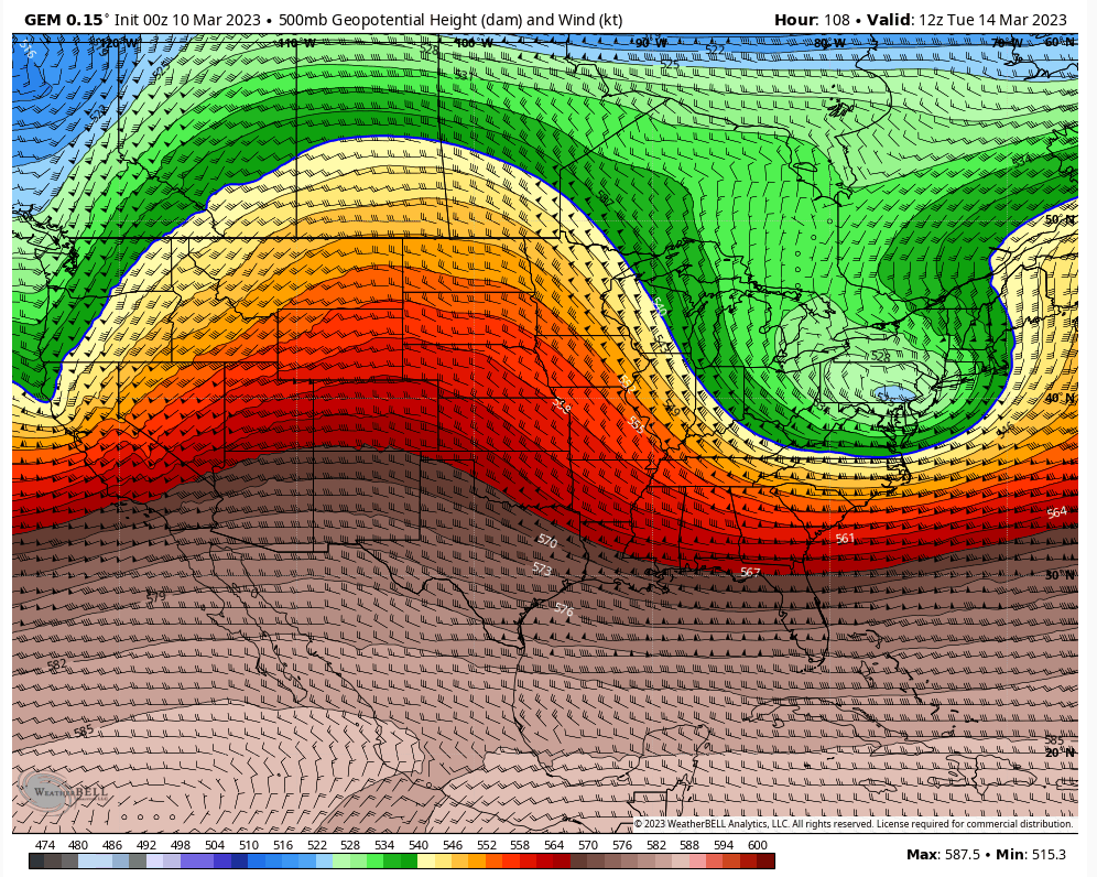
Great posts as usual sroc. I like Canadian 500mb. Digs that ULL enough for feasibility. Most models have in common is negatively tilted trough, so that's telling me the ULL is going to explode. It's a question of whether it's in time. I definitely want to see models digging this more. And yes that depends on the ridge not getting disturbed and pumping.

heehaw453- Advanced Forecaster

- Posts : 3906
Reputation : 86
Join date : 2014-01-20
Location : Bedminster Township, PA Elevation 600' ASL
kalleg likes this post
 Re: March 13th-14th 2023 Big Dog Potential
Good analysis Scott. I have not had enough time to dig deeply into this storm yet, but from my brief look this morning, this is likely the only shot for the region to have a significant storm this winter. Late season Miller A's tend to be rather robust, but at the same time often have boundary layer temp issues that need to be overcome.
With that being said, we have a pretty classic UL jet structure for EC cyclogensis, and a fairly favorable midlevel set up. With the surface low initiating at such a low latitude, there is plenty of time for the ETC to become rather mature before making it to our latitude. This can help in the long run with any boundary layer issues.
All in all, looking at the pattern progression, this is a pretty textbook set up. I think things at this point probably lean towards the Euro camp than the GFS, which quite frankly, has a very odd UL set up that confuses me.

Quietace- Meteorologist - Mod

- Posts : 3689
Reputation : 33
Join date : 2013-01-07
Age : 27
Location : Point Pleasant, NJ
sroc4 likes this post
 Re: March 13th-14th 2023 Big Dog Potential
heehaw453 wrote:Great posts as usual sroc. I like Canadian 500mb. Digs that ULL enough for feasibility. Most models have in common is negatively tilted trough, so that's telling me the ULL is going to explode. It's a question of whether it's in time. I definitely want to see models digging this more. And yes that depends on the ridge not getting disturbed and pumping.
I will reach out to my friends Hans and Franz and see if they can help with the western ridge.

_________________
"In weather and in life, there's no winning and losing; there's only winning and learning."
WINTER 2012/2013 TOTALS 43.65"WINTER 2017/2018 TOTALS 62.85" WINTER 2022/2023 TOTALS 4.9"
WINTER 2013/2014 TOTALS 64.85"WINTER 2018/2019 TOTALS 14.25" WINTER 2023/2024 TOTALS 13.1"
WINTER 2014/2015 TOTALS 71.20"WINTER 2019/2020 TOTALS 6.35"
WINTER 2015/2016 TOTALS 35.00"WINTER 2020/2021 TOTALS 37.75"
WINTER 2016/2017 TOTALS 42.25"WINTER 2021/2022 TOTALS 31.65"

sroc4- Admin

- Posts : 8354
Reputation : 302
Join date : 2013-01-07
Location : Wading River, LI
heehaw453 and SENJsnowman like this post
 Re: March 13th-14th 2023 Big Dog Potential
This is true. It's about progressive timing. The ETC and its super level structure need time to mature, to the point that the trough axis becomes "negatively tilted". I will say that even and not explosive, and neutral solution will allow for some snowfall across the region, just not likely in the coastal plan as you will not have the dynamic temperature impact of a intense-late season ETC.heehaw453 wrote:Great posts as usual sroc. I like Canadian 500mb. Digs that ULL enough for feasibility. Most models have in common is negatively tilted trough, so that's telling me the ULL is going to explode. It's a question of whether it's in time. I definitely want to see models digging this more. And yes that depends on the ridge not getting disturbed and pumping.

Quietace- Meteorologist - Mod

- Posts : 3689
Reputation : 33
Join date : 2013-01-07
Age : 27
Location : Point Pleasant, NJ
heehaw453 likes this post
 Re: March 13th-14th 2023 Big Dog Potential
Great analysis! Still seeing lots of warm air….as the models evolve should we see that change to a colder solution?
Coachgriff- Posts : 57
Reputation : 0
Join date : 2022-01-29
 Re: March 13th-14th 2023 Big Dog Potential
To me where I am, I see the cold, just cold enough, overnight. By around sunrise it will be warm enough to switch over to rain
It also “may” trend colder but looking at the day’s high tomorrow, enjoy any snow before it melts on the ground and day warmth moves anything to rain
It also “may” trend colder but looking at the day’s high tomorrow, enjoy any snow before it melts on the ground and day warmth moves anything to rain

dkodgis- Senior Enthusiast

- Posts : 2560
Reputation : 98
Join date : 2013-12-29
 Re: March 13th-14th 2023 Big Dog Potential
Coachgriff wrote:Great analysis! Still seeing lots of warm air….as the models evolve should we see that change to a colder solution?
Hey coach. "seeing lots of warm air" is a very broad stroked statement. Obv depending on where you live this may or may not mean anything. This set up is such that the timing and extent of phasing will dictate strength and track of the storm.
A strengthening storm will draw in the cold air on the N, NW and Westerns flanks of this storm. No question. If you're just looking at a point and click app on your phone or PC and see temps for your area too warm its because thats the current model consensus for the app. But As we have shown, models are still in disagreement in some of the big picture upper level items. Small changes in the upper levels will lead to HUGE changes at the surface for better or worse. Storm track and intensity dictates everything for your backyard.
_________________
"In weather and in life, there's no winning and losing; there's only winning and learning."
WINTER 2012/2013 TOTALS 43.65"WINTER 2017/2018 TOTALS 62.85" WINTER 2022/2023 TOTALS 4.9"
WINTER 2013/2014 TOTALS 64.85"WINTER 2018/2019 TOTALS 14.25" WINTER 2023/2024 TOTALS 13.1"
WINTER 2014/2015 TOTALS 71.20"WINTER 2019/2020 TOTALS 6.35"
WINTER 2015/2016 TOTALS 35.00"WINTER 2020/2021 TOTALS 37.75"
WINTER 2016/2017 TOTALS 42.25"WINTER 2021/2022 TOTALS 31.65"

sroc4- Admin

- Posts : 8354
Reputation : 302
Join date : 2013-01-07
Location : Wading River, LI
CPcantmeasuresnow, kalleg, heehaw453, billg315, Meepers55 and Coachgriff like this post
 Re: March 13th-14th 2023 Big Dog Potential
I feel a bit more intrigued about this one but not fully biting till I see the GFS go towards the Euro. Reel it in guys!

jmanley32- Senior Enthusiast

- Posts : 20535
Reputation : 108
Join date : 2013-12-12
Age : 43
Location : Yonkers, NY
 Re: March 13th-14th 2023 Big Dog Potential
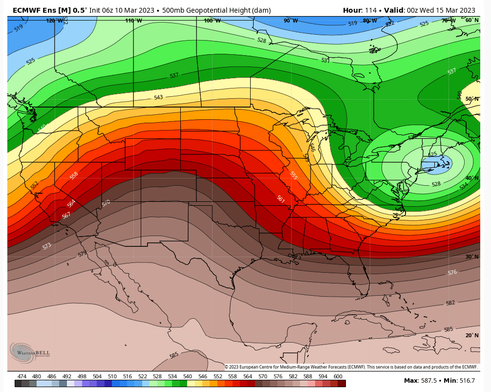
I'm looking at the 06Z EPS I want to see this deepen over Southern NJ latitude not SNE. That deepening is where it stalls and anything at or above that line gets a good snowfall. It's too early to say one way or the other, but my money right now is just a little late for most. Of course sroc land may be different being further east. I need to start seeing this deepening on run/run consistently over southern NJ latitude before I bite.

heehaw453- Advanced Forecaster

- Posts : 3906
Reputation : 86
Join date : 2014-01-20
Location : Bedminster Township, PA Elevation 600' ASL
CPcantmeasuresnow, kalleg and CNWestMilford like this post
 Re: March 13th-14th 2023 Big Dog Potential
sroc4 wrote:Coachgriff wrote:Great analysis! Still seeing lots of warm air….as the models evolve should we see that change to a colder solution?
Hey coach. "seeing lots of warm air" is a very broad stroked statement. Obv depending on where you live this may or may not mean anything. This set up is such that the timing and extent of phasing will dictate strength and track of the storm.
A strengthening storm will draw in the cold air on the N, NW and Westerns flanks of this storm. No question. If you're just looking at a point and click app on your phone or PC and see temps for your area too warm its because thats the current model consensus for the app. But As we have shown, models are still in disagreement in some of the big picture upper level items. Small changes in the upper levels will lead to HUGE changes at the surface for better or worse. Storm track and intensity dictates everything for your backyard.
Thanks SROC…I was curious if the development of the storm would draw more cold air into the mix as the current temperature forecast is far too warm for snow in most of NJ. Looking forward to seeing how this storm winds up…it definitely has a lot of the elements that have been missing this winter!

Coachgriff- Posts : 57
Reputation : 0
Join date : 2022-01-29
sroc4 likes this post
heehaw453- Advanced Forecaster

- Posts : 3906
Reputation : 86
Join date : 2014-01-20
Location : Bedminster Township, PA Elevation 600' ASL
 Re: March 13th-14th 2023 Big Dog Potential
Is nyc still in the game for either 1” or possibly 1foot
Carvin- Posts : 44
Reputation : 2
Join date : 2019-01-09
 Re: March 13th-14th 2023 Big Dog Potential
May need a road trip to LHV on Monday!
heehaw453- Advanced Forecaster

- Posts : 3906
Reputation : 86
Join date : 2014-01-20
Location : Bedminster Township, PA Elevation 600' ASL
 Re: March 13th-14th 2023 Big Dog Potential
heehaw453 wrote:May need a road trip to LHV on Monday!
Parking rates cheap in my driveway in Monroe NY,LOL.

docstox12- Wx Statistician Guru

- Posts : 8530
Reputation : 222
Join date : 2013-01-07
Age : 73
Location : Monroe NY
brownie, essexcountypete and heehaw453 like this post
 Re: March 13th-14th 2023 Big Dog Potential
It's just starting to look to me that this will blow up and latitude will matter as will mid-level temps. You guys maybe in a really good spot for this one!docstox12 wrote:heehaw453 wrote:May need a road trip to LHV on Monday!
Parking rates cheap in my driveway in Monroe NY,LOL.
heehaw453- Advanced Forecaster

- Posts : 3906
Reputation : 86
Join date : 2014-01-20
Location : Bedminster Township, PA Elevation 600' ASL
docstox12 likes this post
 Re: March 13th-14th 2023 Big Dog Potential
So is southern Westchester not looking to great, not a snowfall IMBY question more of a will we get hit good potential, I know nothing set in stone. I don't need (I do want) a big one but at least something bigger than what will maybe be nothing tonight for us down here.heehaw453 wrote:It's just starting to look to me that this will blow up and latitude will matter as will mid-level temps. You guys maybe in a really good spot for this one!docstox12 wrote:heehaw453 wrote:May need a road trip to LHV on Monday!
Parking rates cheap in my driveway in Monroe NY,LOL.

jmanley32- Senior Enthusiast

- Posts : 20535
Reputation : 108
Join date : 2013-12-12
Age : 43
Location : Yonkers, NY
 Re: March 13th-14th 2023 Big Dog Potential
12z GFS sifted snow amouns a bit further south than 06z, its just a bit too late for NJ and NYC area but north of there holy cow, 20+. Hoping GFS is going to show a euro solution and that they are able to blow up earlier so we all get smacked. Trying to stay cautiously optimistic as sroc would say.

jmanley32- Senior Enthusiast

- Posts : 20535
Reputation : 108
Join date : 2013-12-12
Age : 43
Location : Yonkers, NY
 Re: March 13th-14th 2023 Big Dog Potential
In my experience over the years ULLs will only dig so much. There's usually something which caps how much it digs. It's a time and slope thing. So it depends on the ridge and how much time it has. I don't like the angle it's coming from one bit. We tend to do better with bowling ball ULLs when the energy comes on shore at say San Francisco not Portland Oregon like this one. I just think we continue to see uphill battle hoping that we get that ULL to dig more. LHV on north in the game but not sure below that latitude.jmanley32 wrote:So is southern Westchester not looking to great, not a snowfall IMBY question more of a will we get hit good potential, I know nothing set in stone. I don't need (I do want) a big one but at least something bigger than what will maybe be nothing tonight for us down here.heehaw453 wrote:It's just starting to look to me that this will blow up and latitude will matter as will mid-level temps. You guys maybe in a really good spot for this one!docstox12 wrote:heehaw453 wrote:May need a road trip to LHV on Monday!
Parking rates cheap in my driveway in Monroe NY,LOL.
heehaw453- Advanced Forecaster

- Posts : 3906
Reputation : 86
Join date : 2014-01-20
Location : Bedminster Township, PA Elevation 600' ASL
 Re: March 13th-14th 2023 Big Dog Potential
K thanks, will check in maybe over weekend or Monday, but I guess doesn't look good, meh what's new down here.heehaw453 wrote:In my experience over the years ULLs will only dig so much. There's usually something which caps how much it digs. It's a time and slope thing. So it depends on the ridge and how much time it has. I don't like the angle it's coming from one bit. We tend to do better with bowling ball ULLs when the energy comes on shore at say San Francisco not Portland Oregon like this one. I just think we continue to see uphill battle hoping that we get that ULL to dig more. LHV on north in the game but not sure below that latitude.jmanley32 wrote:So is southern Westchester not looking to great, not a snowfall IMBY question more of a will we get hit good potential, I know nothing set in stone. I don't need (I do want) a big one but at least something bigger than what will maybe be nothing tonight for us down here.heehaw453 wrote:It's just starting to look to me that this will blow up and latitude will matter as will mid-level temps. You guys maybe in a really good spot for this one!docstox12 wrote:heehaw453 wrote:May need a road trip to LHV on Monday!
Parking rates cheap in my driveway in Monroe NY,LOL.

jmanley32- Senior Enthusiast

- Posts : 20535
Reputation : 108
Join date : 2013-12-12
Age : 43
Location : Yonkers, NY
heehaw453- Advanced Forecaster

- Posts : 3906
Reputation : 86
Join date : 2014-01-20
Location : Bedminster Township, PA Elevation 600' ASL
 Re: March 13th-14th 2023 Big Dog Potential
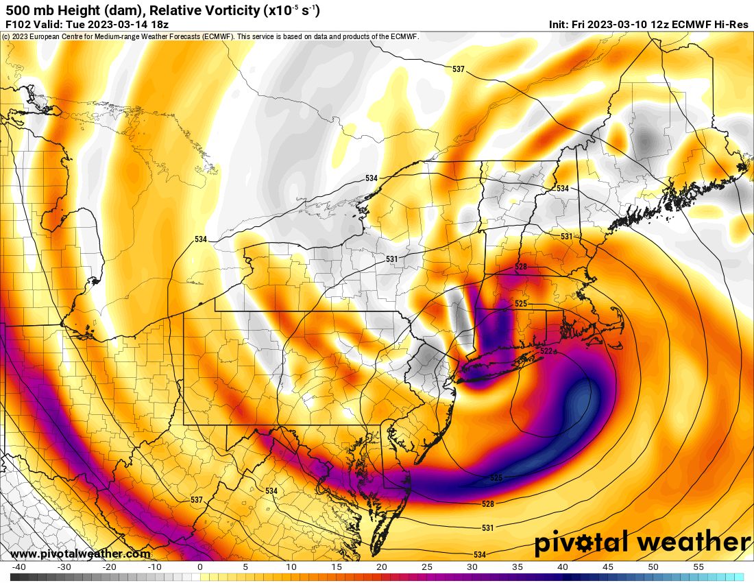
There is a meso low inside over WLI on this that may jusy may cause this to have thermals out of whack leeping teh area warmer than forecasted. If this is the case then BL won't be much of an issue as the dynamics take over as well as it pulls in and down the arctic air. These Nor'easters are never set in stone and will have wiggles of 25-50 miles with run to run variance. Next best runs are 0Z and see if the EURO holds.

_________________
Mugs
AKA:King: Snow Weenie
Self Proclaimed
WINTER 2014-15 : 55.12" +.02 for 6 coatings (avg. 35")
WINTER 2015-16 Total - 29.8" (Avg 35")
WINTER 2016-17 : 39.5" so far

amugs- Advanced Forecaster - Mod

- Posts : 15095
Reputation : 213
Join date : 2013-01-07
Age : 54
Location : Hillsdale,NJ
heehaw453 likes this post
 Re: March 13th-14th 2023 Big Dog Potential
Correct me if I’m wrong, but I believe the surface map did not matchup with the H5 map. A south Jersey capture would argue for colder thermals/ more prolific snowfall in our area. Edit: Thanks Mugs for the post^^^. That might have been the issue with the Euro.
Last edited by nutleyblizzard on Fri Mar 10, 2023 1:46 pm; edited 1 time in total

nutleyblizzard- Senior Enthusiast

- Posts : 1954
Reputation : 41
Join date : 2014-01-30
Age : 58
Location : Nutley, new jersey
sroc4, essexcountypete and heehaw453 like this post
 Re: March 13th-14th 2023 Big Dog Potential
Yeah. I don't bother with surface maps until 48 hrs usually. I would take my chances with that type of setup any day of the week including Sunday.nutleyblizzard wrote:Correct me if I’m wrong, but I believe the surface map did not matchup with the H5 map. A south Jersey capture would argue for colder thermals/ more prolific snowfall in our area.
heehaw453- Advanced Forecaster

- Posts : 3906
Reputation : 86
Join date : 2014-01-20
Location : Bedminster Township, PA Elevation 600' ASL
amugs likes this post
Page 1 of 10 • 1, 2, 3, 4, 5, 6, 7, 8, 9, 10 
Page 1 of 10
Permissions in this forum:
You cannot reply to topics in this forum|
|
|

 Home
Home