March 13th-14th 2023 Big Dog Potential
+22
SENJsnowman
weatherwatchermom
essexcountypete
Dunnzoo
aiannone
MattyICE
CPcantmeasuresnow
CNWestMilford
phil155
lglickman1
hyde345
Frank_Wx
nutleyblizzard
amugs
docstox12
Carvin
jmanley32
dkodgis
Coachgriff
Quietace
heehaw453
sroc4
26 posters
Page 5 of 10
Page 5 of 10 •  1, 2, 3, 4, 5, 6, 7, 8, 9, 10
 Re: March 13th-14th 2023 Big Dog Potential
Not bad if its true, which I am doubtful still I want to see SR model runs.CNWestMilford wrote:jmanley32 wrote:Do you have a euro snow map? That might bode well.CNWestMilford wrote:jmanley32 wrote:Well 18z GFS reverted back to a solution that keeps almost everyone rain and shifted the heaviest snow north and east. And the cycle goes round and round. I presume this is not what Frank wanted to see or any of you all.
But the GFS ensembles disagree with the OP. New Euro is further south and west.
jmanley32- Senior Enthusiast

- Posts : 20535
Join date : 2013-12-12
heehaw453- Advanced Forecaster

- Posts : 3906
Join date : 2014-01-20
heehaw453- Advanced Forecaster

- Posts : 3906
Reputation : 86
Join date : 2014-01-20
Location : Bedminster Township, PA Elevation 600' ASL
 Re: March 13th-14th 2023 Big Dog Potential
Ill take the 00z cmc plz! Wow

jmanley32- Senior Enthusiast

- Posts : 20535
Reputation : 108
Join date : 2013-12-12
Age : 43
Location : Yonkers, NY
 Re: March 13th-14th 2023 Big Dog Potential
jmanley32 wrote:Ill take the 00z cmc plz! Wow
I know you’re just playing with these maps Jman but in the last two days alone I’ve seen models with anywhere from 4 to 36 inches over my house. The funny thing is I’m not even sure I’ll get 4 yet, and I’m not even dreaming of any chance at 36. Anyway WS Watch here for 5-10. That seems more reasonable.
With everything still so up in the air I may take a break tomorrow and just see what Monday brings. I actually have PTSD from to much model watching since last Sunday.

CPcantmeasuresnow- Wx Statistician Guru

- Posts : 7274
Reputation : 230
Join date : 2013-01-07
Age : 103
Location : Eastern Orange County, NY
docstox12, kalleg and heehaw453 like this post
 Re: March 13th-14th 2023 Big Dog Potential
lol you do what ypu need to do yes i have seen o to 17 imby on these useless models. 48 hrs away and they got no clue. Cmc was a massive coastal i dont think it had that small lp into li. Honestly i think ur in a good dpot to get plasterrd. And no i dont mean booze.CPcantmeasuresnow wrote:jmanley32 wrote:Ill take the 00z cmc plz! Wow
I know you’re just playing with these maps Jman but in the last two days alone I’ve seen models with anywhere from 4 to 36 inches over my house. The funny thing is I’m not even sure I’ll get 4 yet, and I’m not even dreaming of any chance at 36.
With everything still so up in the air I may take a break tomorrow and just see what Monday brings. I actually have PTSD from to much model watching since last Sunday.

jmanley32- Senior Enthusiast

- Posts : 20535
Reputation : 108
Join date : 2013-12-12
Age : 43
Location : Yonkers, NY
docstox12 and CPcantmeasuresnow like this post
 Re: March 13th-14th 2023 Big Dog Potential
From tonight’s CMC UKIE and Euro it seems like NYC area and parts of LI back in the game for a decent hit. Let’s see what tomorrow brings.

CPcantmeasuresnow- Wx Statistician Guru

- Posts : 7274
Reputation : 230
Join date : 2013-01-07
Age : 103
Location : Eastern Orange County, NY
 Re: March 13th-14th 2023 Big Dog Potential
25 degrees, clear ,calm wind.NWS holding fast ATM to last nights WS watch and 5 to 10 for my area.In a terrible season like this, will be happy to get 6 .Coming up to nowcast.Any change in the phasing or 25 to 50 mile wobble will have big effects,Looking like a March Catskills special.One March many years ago, a Buddy who owns a place near Cooperstown got 36 inches while NJ had heavy rain.
Whatever this season produced, it was a throwback to a classic "areas N and W of the City" getting more snow.This is how it was when I was a kid.
Math up in Albany and Hyde look like they are in the sweet spot.
Whatever this season produced, it was a throwback to a classic "areas N and W of the City" getting more snow.This is how it was when I was a kid.
Math up in Albany and Hyde look like they are in the sweet spot.

docstox12- Wx Statistician Guru

- Posts : 8530
Reputation : 222
Join date : 2013-01-07
Age : 73
Location : Monroe NY
 Re: March 13th-14th 2023 Big Dog Potential
We take the models like they are piggy banks. We hold them upside down and shake them to get forecasts out of them. Of course meteorology is despite all time, attention, resources , and people hours applied to it, is inexact; sometimes things aren’t known until after an event. This is when I press my nose and hands to the window and I am unscientific. I am a kid again

dkodgis- Senior Enthusiast

- Posts : 2560
Reputation : 98
Join date : 2013-12-29
docstox12, CPcantmeasuresnow, kalleg and Meepers55 like this post
 Re: March 13th-14th 2023 Big Dog Potential
This is a complicated setup and I’m sure it’s frustrating because it feels like we’re pretty close to go time with no real consensus. I think with a complex storm like this the Meso models need to get into range to really give an idea of a final outcome. They are just coming into their outer reliable ranges today. This will have additional ups and downs and essentially come down in fringe areas to nowcasting. If we accept that now then we can just enjoy the ride in what has been a truly horrific winter. There will be busts. One run is going to give you 12 then the next 2”. Let’s buckle up and see what comes today!
MattyICE- Advanced Forecaster

- Posts : 249
Reputation : 6
Join date : 2017-11-10
Age : 38
Location : Clifton, NJ (Eastern Passaic County)
Frank_Wx and kalleg like this post
 Re: March 13th-14th 2023 Big Dog Potential
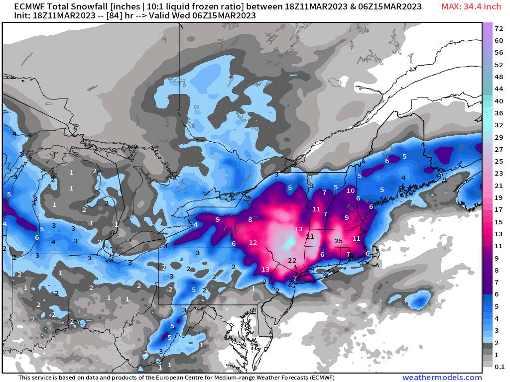
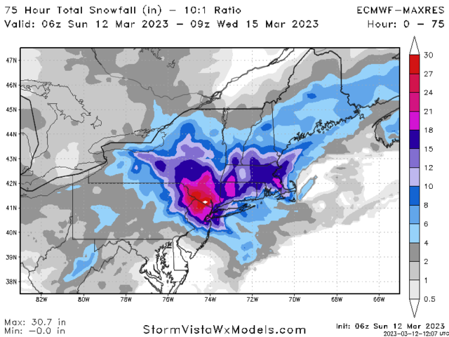
Run after run the EURO keeps showing this meso low just off the coast, allowing colder air to infiltrate down to the coast. It also keeps showing the CCB over NYC Metro. Here is the 06z snow map. I’ll see if I can find a depth map some place

_________________
_______________________________________________________________________________________________________
CLICK HERE to view NJ Strong Snowstorm Classifications
 Re: March 13th-14th 2023 Big Dog Potential
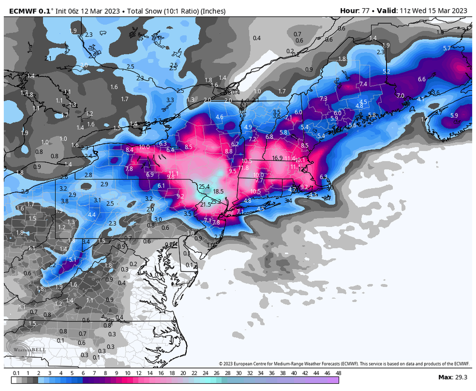
Ratios are more like 7:1 for the coast so I think this is overdone by a bit. But if the EURO is anywhere near accurate we’re looking at a near Roodzilla territory N&W of NYC
_________________
_______________________________________________________________________________________________________
CLICK HERE to view NJ Strong Snowstorm Classifications
 Re: March 13th-14th 2023 Big Dog Potential
Here’s the NAM just for comparison. I mean, is this the same storm? Laughable difference


_________________
_______________________________________________________________________________________________________
CLICK HERE to view NJ Strong Snowstorm Classifications
 Re: March 13th-14th 2023 Big Dog Potential
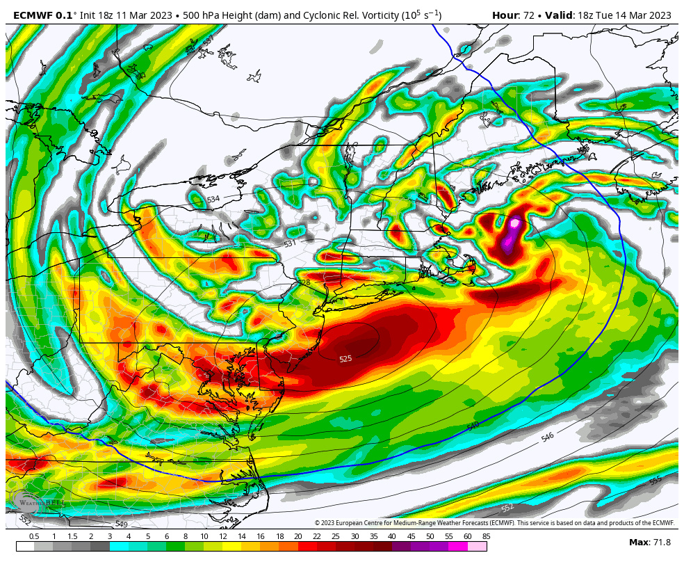
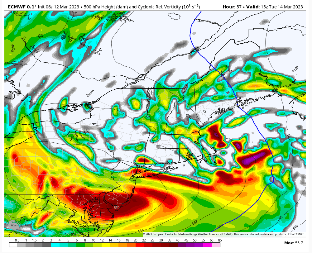
Euro ULL location gives this a chance north of Trenton.
I've pointed out that models were bad on that last storm. This ridge is better than last storm though. I also pointed out the s/w energy came ashore in Oregon which seems like this should correct more north. The further north it comes the worse it will be for snow in our area.
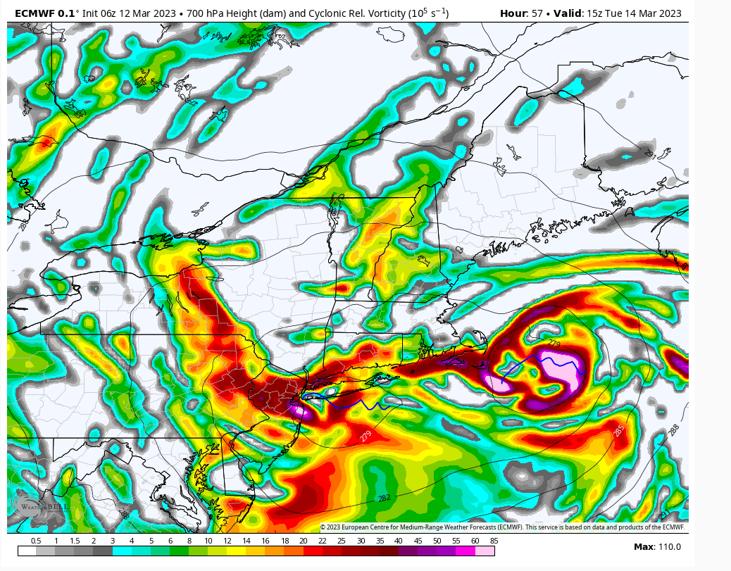
Where the best forcing sets up don't even think models have a handle on. Look at the 700mb setup. There's two disparate pieces of energy and exactly where that sets up good luck. That's why it's thumping in NYC down to Monmouth Cty.
As Matty said super high bust potential here. Outside of LHV, NW NJ everyone should be really cautious.
500mb ULL
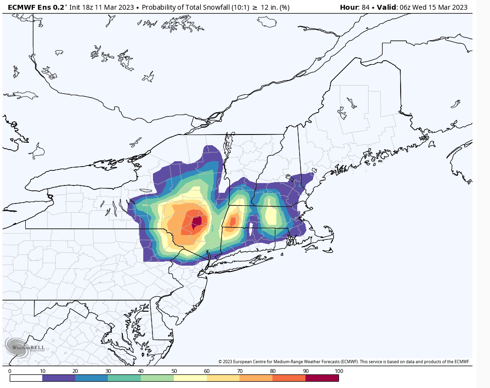
The 700mb
I've pointed out that models were bad on that last storm. This ridge is better than last storm though. I also pointed out the s/w energy came ashore in Oregon which seems like this should correct more north. The further north it comes the worse it will be for snow in our area.
Where the best forcing sets up don't even think models have a handle on. Look at the 700mb setup. There's two disparate pieces of energy and exactly where that sets up good luck. That's why it's thumping in NYC down to Monmouth Cty.
As Matty said super high bust potential here. Outside of LHV, NW NJ everyone should be really cautious.
500mb ULL

The 700mb

heehaw453- Advanced Forecaster

- Posts : 3906
Reputation : 86
Join date : 2014-01-20
Location : Bedminster Township, PA Elevation 600' ASL
 Re: March 13th-14th 2023 Big Dog Potential
thing of beauty even at 7:1 but as you said above look at nsm. Gfs also closer to nam then euro. How muck stock are you put in the euro for nyc metro to actually see wsw level snows?Frank_Wx wrote:
Ratios are more like 7:1 for the coast so I think this is overdone by a bit. But if the EURO is anywhere near accurate we’re looking at a near Roodzilla territory N&W of NYC

jmanley32- Senior Enthusiast

- Posts : 20535
Reputation : 108
Join date : 2013-12-12
Age : 43
Location : Yonkers, NY
 Re: March 13th-14th 2023 Big Dog Potential
heehaw453 wrote:Euro ULL location gives this a chance north of Trenton.
I've pointed out that models were bad on that last storm. This ridge is better than last storm though. I also pointed out the s/w energy came ashore in Oregon which seems like this should correct more north. The further north it comes the worse it will be for snow in our area.
Where the best forcing sets up don't even think models have a handle on. Look at the 700mb setup. There's two disparate pieces of energy and exactly where that sets up good luck. That's why it's thumping in NYC down to Monmouth Cty.
As Matty said super high bust potential here. Outside of LHV, NW NJ everyone should be really cautious.
500mb ULL
The 700mb
Agreed, but EURO does have some mode support. The 3KM NAM, SREFS, and Canadian suites. Each is a little different where banding sets up, but in general have accumulating snow down the coast.
This starts as rain along the coast before changing over to heavy snow. Also, the best forcing sets up N&W of NYC regardless. So the Godzilla snow amounts will be N&W. The NJ and NYC forecasts though are very difficult right now. I’ll be waiting for the 12z runs before releasing a snow map.
_________________
_______________________________________________________________________________________________________
CLICK HERE to view NJ Strong Snowstorm Classifications
kalleg and heehaw453 like this post
 Re: March 13th-14th 2023 Big Dog Potential
do you have the 00z map was it similar? And cmc was sililar in totals so we have 2 models kinda in same camp.Frank_Wx wrote:Run after run the EURO keeps showing this meso low just off the coast, allowing colder air to infiltrate down to the coast. It also keeps showing the CCB over NYC Metro. Here is the 06z snow map. I’ll see if I can find a depth map some place

jmanley32- Senior Enthusiast

- Posts : 20535
Reputation : 108
Join date : 2013-12-12
Age : 43
Location : Yonkers, NY
 Re: March 13th-14th 2023 Big Dog Potential
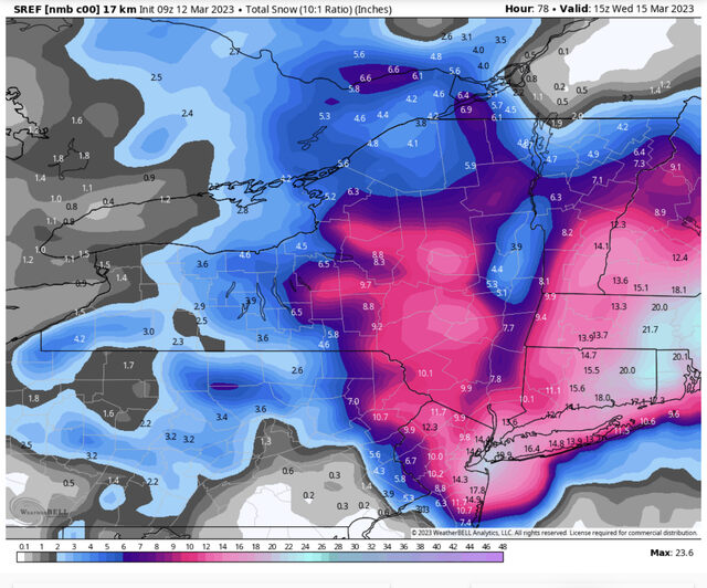
The NMB had 0 inches last run for NYC. Now look at it. These types of swings are laughable. It’s hard to take the NYC trend seriously until we see more consistency which is why todays 12z runs will be BIG

_________________
_______________________________________________________________________________________________________
CLICK HERE to view NJ Strong Snowstorm Classifications
heehaw453 likes this post
heehaw453- Advanced Forecaster

- Posts : 3906
Reputation : 86
Join date : 2014-01-20
Location : Bedminster Township, PA Elevation 600' ASL
 Re: March 13th-14th 2023 Big Dog Potential
jmanley32 wrote:do you have the 00z map was it similar? And cmc was sililar in totals so we have 2 models kinda in same camp.Frank_Wx wrote:Run after run the EURO keeps showing this meso low just off the coast, allowing colder air to infiltrate down to the coast. It also keeps showing the CCB over NYC Metro. Here is the 06z snow map. I’ll see if I can find a depth map some place
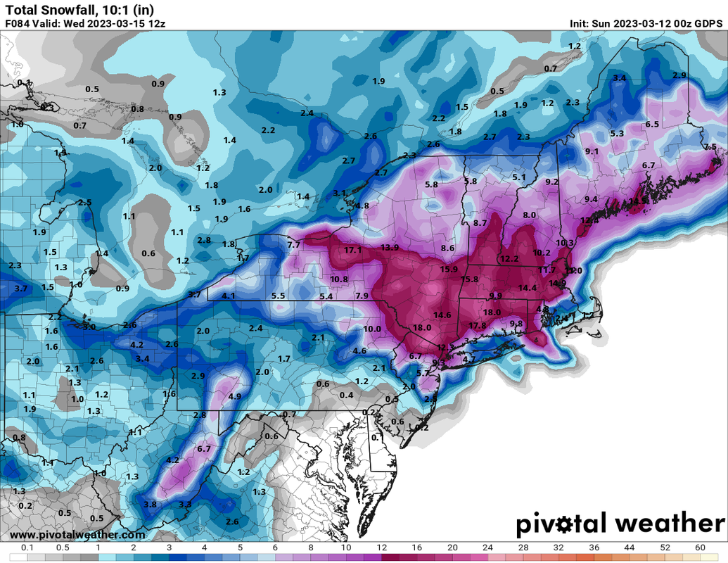
_________________
_______________________________________________________________________________________________________
CLICK HERE to view NJ Strong Snowstorm Classifications
 Re: March 13th-14th 2023 Big Dog Potential
Wow on 3km nam and sref maybe euro cmc 3km nam and sref are onto st. I sure hope but am tempering especially since nws isnt biting yet anywats if they do. Major model runs at 12z!

jmanley32- Senior Enthusiast

- Posts : 20535
Reputation : 108
Join date : 2013-12-12
Age : 43
Location : Yonkers, NY
 Re: March 13th-14th 2023 Big Dog Potential
thats the euro says gdps. Thats ok fpund it on pivotal i didnt realize ypu could see hi res euro on there. So 06z upped snti even more. But you know the 06z and 18z.Frank_Wx wrote:jmanley32 wrote:do you have the 00z map was it similar? And cmc was sililar in totals so we have 2 models kinda in same camp.Frank_Wx wrote:Run after run the EURO keeps showing this meso low just off the coast, allowing colder air to infiltrate down to the coast. It also keeps showing the CCB over NYC Metro. Here is the 06z snow map. I’ll see if I can find a depth map some place

jmanley32- Senior Enthusiast

- Posts : 20535
Reputation : 108
Join date : 2013-12-12
Age : 43
Location : Yonkers, NY
 Re: March 13th-14th 2023 Big Dog Potential
I have seen you post this a few times, and just want to point out that literature written on intrinsic NWP predictability says there is no correlation between the skill of NWP on prior systems and the one after, often because if models preform poorly on one, it is often due to an area of heightened uncertainty, that once that area is resolved, skill returns. Hence why skill drop outs on NWP only last for short temporal periods. Part of my M.S. thesis discussed this in TC forecasts.heehaw453 wrote:Euro ULL location gives this a chance north of Trenton.
I've pointed out that models were bad on that last storm. This ridge is better than last storm though. I also pointed out the s/w energy came ashore in Oregon which seems like this should correct more north. The further north it comes the worse it will be for snow in our area.
Where the best forcing sets up don't even think models have a handle on. Look at the 700mb setup. There's two disparate pieces of energy and exactly where that sets up good luck. That's why it's thumping in NYC down to Monmouth Cty.
As Matty said super high bust potential here. Outside of LHV, NW NJ everyone should be really cautious.
500mb ULL
The 700mb

Quietace- Meteorologist - Mod

- Posts : 3689
Reputation : 33
Join date : 2013-01-07
Age : 27
Location : Point Pleasant, NJ
kalleg and heehaw453 like this post
 Re: March 13th-14th 2023 Big Dog Potential
jmanley32 wrote:thats the euro says gdps. Thats ok fpund it on pivotal i didnt realize ypu could see hi res euro on there. So 06z upped snti even more. But you know the 06z and 18z.Frank_Wx wrote:jmanley32 wrote:do you have the 00z map was it similar? And cmc was sililar in totals so we have 2 models kinda in same camp.Frank_Wx wrote:Run after run the EURO keeps showing this meso low just off the coast, allowing colder air to infiltrate down to the coast. It also keeps showing the CCB over NYC Metro. Here is the 06z snow map. I’ll see if I can find a depth map some place
We interrupt this regularly scheduled thread on the Mainland Weather Board to bring an urgent message to CP aka Wintercoldandsnoware a myth......IGNORE these clown snow maps! Believing they will come true and having it bust can have severe mental implications, including a complete collapse!That is all.
Brought to you by your genial Director of the OTI Sanitarium.

docstox12- Wx Statistician Guru

- Posts : 8530
Reputation : 222
Join date : 2013-01-07
Age : 73
Location : Monroe NY
kalleg, jmanley32 and SENJsnowman like this post
 Re: March 13th-14th 2023 Big Dog Potential
docstox12 wrote:jmanley32 wrote:thats the euro says gdps. Thats ok fpund it on pivotal i didnt realize ypu could see hi res euro on there. So 06z upped snti even more. But you know the 06z and 18z.Frank_Wx wrote:jmanley32 wrote:do you have the 00z map was it similar? And cmc was sililar in totals so we have 2 models kinda in same camp.Frank_Wx wrote:Run after run the EURO keeps showing this meso low just off the coast, allowing colder air to infiltrate down to the coast. It also keeps showing the CCB over NYC Metro. Here is the 06z snow map. I’ll see if I can find a depth map some place
We interrupt this regularly scheduled thread on the Mainland Weather Board to bring an urgent message to CP aka Wintercoldandsnoware a myth......IGNORE these clown snow maps! Believing they will come true and having it bust can have severe mental implications, including a complete collapse!That is all.
Brought to you by your genial Director of the OTI Sanitarium.
If the 12z runs look like this I may need seek asylum in OTI
_________________
_______________________________________________________________________________________________________
CLICK HERE to view NJ Strong Snowstorm Classifications
docstox12 and kalleg like this post
 Re: March 13th-14th 2023 Big Dog Potential
lol yup nice to look at but hard to put stock in yet.docstox12 wrote:jmanley32 wrote:thats the euro says gdps. Thats ok fpund it on pivotal i didnt realize ypu could see hi res euro on there. So 06z upped snti even more. But you know the 06z and 18z.Frank_Wx wrote:jmanley32 wrote:do you have the 00z map was it similar? And cmc was sililar in totals so we have 2 models kinda in same camp.Frank_Wx wrote:Run after run the EURO keeps showing this meso low just off the coast, allowing colder air to infiltrate down to the coast. It also keeps showing the CCB over NYC Metro. Here is the 06z snow map. I’ll see if I can find a depth map some place
We interrupt this regularly scheduled thread on the Mainland Weather Board to bring an urgent message to CP aka Wintercoldandsnoware a myth......IGNORE these clown snow maps! Believing they will come true and having it bust can have severe mental implications, including a complete collapse!That is all.
Brought to you by your genial Director of the OTI Sanitarium.

jmanley32- Senior Enthusiast

- Posts : 20535
Reputation : 108
Join date : 2013-12-12
Age : 43
Location : Yonkers, NY
docstox12 likes this post
 Re: March 13th-14th 2023 Big Dog Potential
Frank_Wx wrote:docstox12 wrote:jmanley32 wrote:thats the euro says gdps. Thats ok fpund it on pivotal i didnt realize ypu could see hi res euro on there. So 06z upped snti even more. But you know the 06z and 18z.Frank_Wx wrote:jmanley32 wrote:do you have the 00z map was it similar? And cmc was sililar in totals so we have 2 models kinda in same camp.Frank_Wx wrote:Run after run the EURO keeps showing this meso low just off the coast, allowing colder air to infiltrate down to the coast. It also keeps showing the CCB over NYC Metro. Here is the 06z snow map. I’ll see if I can find a depth map some place
We interrupt this regularly scheduled thread on the Mainland Weather Board to bring an urgent message to CP aka Wintercoldandsnoware a myth......IGNORE these clown snow maps! Believing they will come true and having it bust can have severe mental implications, including a complete collapse!That is all.
Brought to you by your genial Director of the OTI Sanitarium.
If the 12z runs look like this I may need seek asylum in OTI
Emperor Frank, you have Carte Blanche 24/7 at OTI.
Map mayhem at it's best!

docstox12- Wx Statistician Guru

- Posts : 8530
Reputation : 222
Join date : 2013-01-07
Age : 73
Location : Monroe NY
kalleg likes this post
Page 5 of 10 •  1, 2, 3, 4, 5, 6, 7, 8, 9, 10
Page 5 of 10
Permissions in this forum:
You cannot reply to topics in this forum|
|
|

 Home
Home