
 Search
March 13th-14th 2023 Big Dog Potential
Page 10 of 10 •  1, 2, 3, 4, 5, 6, 7, 8, 9, 10
Re: March 13th-14th 2023 Big Dog Potential
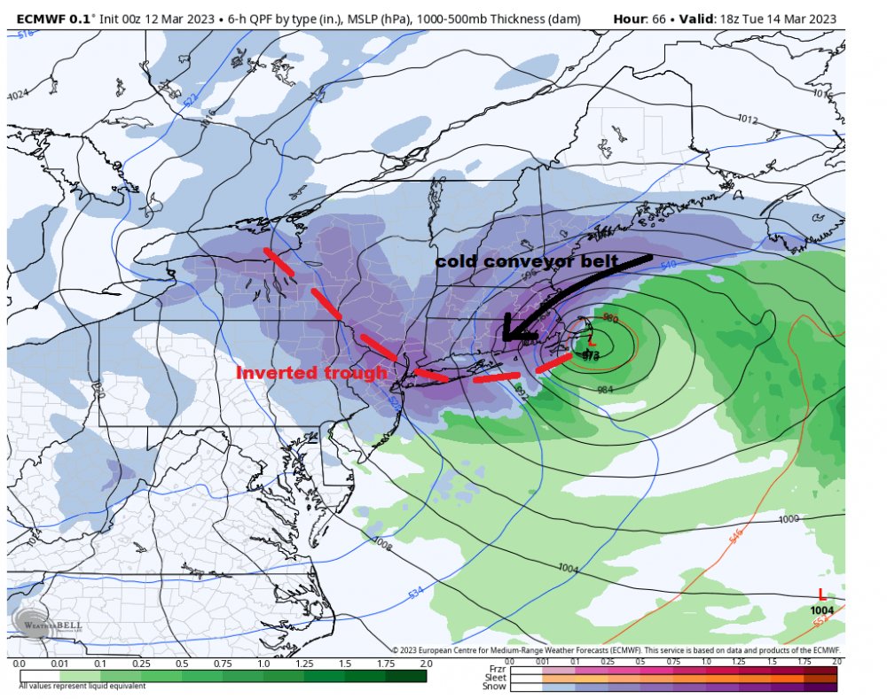
![]() by rb924119 Sun Mar 12, 2023 2:54 pm
by rb924119 Sun Mar 12, 2023 2:54 pm
I think this is likely just noise more than a “shift”. And I also think that “lobe” of vorticity on the eastern side is not necessarily real. The trend of having that be weaker and the “primary” associated with the main trough be stronger continued. That’s what I’m more concerned with. And through 42 I think we were ok. But then after that that eastern “phantom” vorticity tried to stretch everything out and it created a cascade of effects that drew the progression too far to the northeast. But, I’ve been wrong before haha
rb924119- Meteorologist

- Posts : 6928
Join date : 2013-02-06
Re: March 13th-14th 2023 Big Dog Potential
![]() by heehaw453 Sun Mar 12, 2023 2:58 pm
by heehaw453 Sun Mar 12, 2023 2:58 pm
The ULL will drive the whole train. If that it north as it hits the coast then all the mid-level energy will follow suit and you get the BIG snows much further north towards Catskills. Ultimately that's what i believe is going to be the case.CNWestMilford wrote:billg315 wrote:The H5 doesn’t look that different than the prior runs. The 850 look is just slightly further north with the energy and the heavy snow band on the backside shifts about 25-50 miles north.
Its west with the 500mb ULL from 6z but chases the convection to the east.
heehaw453- Advanced Forecaster

- Posts : 3906
Join date : 2014-01-20
CNWestMilford likes this post
Re: March 13th-14th 2023 Big Dog Potential
![]() by Koroptim Sun Mar 12, 2023 3:03 pm
by Koroptim Sun Mar 12, 2023 3:03 pm
Koroptim- Posts : 29
Reputation : 0
Join date : 2013-01-16
Frank_Wx, sroc4, amugs, jmanley32, heehaw453 and Coachgriff like this post
Re: March 13th-14th 2023 Big Dog Potential
![]() by billg315 Sun Mar 12, 2023 3:26 pm
by billg315 Sun Mar 12, 2023 3:26 pm

billg315- Advanced Forecaster - Mod

- Posts : 4483
Reputation : 185
Join date : 2015-01-24
Age : 50
Location : Flemington, NJ
amugs, rb924119, dkodgis, heehaw453 and Meepers55 like this post
Re: March 13th-14th 2023 Big Dog Potential
![]() by CNWestMilford Sun Mar 12, 2023 3:30 pm
by CNWestMilford Sun Mar 12, 2023 3:30 pm
I’m having a hard time believing the Low goes that far east and then somehow swings back west south of Maine??. Where’s the mechanism to do this?heehaw453 wrote:The ULL will drive the whole train. If that it north as it hits the coast then all the mid-level energy will follow suit and you get the BIG snows much further north towards Catskills. Ultimately that's what i believe is going to be the case.CNWestMilford wrote:billg315 wrote:The H5 doesn’t look that different than the prior runs. The 850 look is just slightly further north with the energy and the heavy snow band on the backside shifts about 25-50 miles north.
Its west with the 500mb ULL from 6z but chases the convection to the east.

CNWestMilford- Posts : 43
Reputation : 1
Join date : 2020-12-15
Age : 47
Location : West Milford
amugs likes this post
Re: March 13th-14th 2023 Big Dog Potential
![]() by amugs Sun Mar 12, 2023 3:30 pm
by amugs Sun Mar 12, 2023 3:30 pm
Anyone know about the March super storm 1993 30 years ago the infighting at NWS about the storm?? Many thought climo and it would be a massive rainstorm and others thought what we got but not even to the extent as it took until the day before at earliest to raise the red flag. Now I know it is 2023 not 1993 but even without most advanced tech we still do not know what will be the outcome. Globals struggle with the LP placements due to the massive dynamics of latent heat release by these beasts. Heck even hi res models struggle.
AND RB is the HOUSE so if you do not think is real, then I do not know what to tell ya. Let’s see what we have 18Z and tonight’s 0Z before we may even be able to decipher what will happen in 24 hours. To say GFS is right when for the LOVE Of GOD it’s been a cutter 3 days ago into Syracuse to a major coastal to a weaker storm that jumps east etc. Euro as well has had run to run variance.
Any snow is good.
WE TRACK!!!
EPS MEAN and GEFS actually increased snow amounts and shifted a tad S of 6+ inches

EPS - circled in blue would be zilla's!!

_________________
Mugs
AKA:King: Snow Weenie
Self Proclaimed
WINTER 2014-15 : 55.12" +.02 for 6 coatings (avg. 35")
WINTER 2015-16 Total - 29.8" (Avg 35")
WINTER 2016-17 : 39.5" so far

amugs- Advanced Forecaster - Mod
- Posts : 15095
Reputation : 213
Join date : 2013-01-07
Age : 54
Location : Hillsdale,NJ
rb924119, Lauraanne2 and CNWestMilford like this post
Re: March 13th-14th 2023 Big Dog Potential
![]() by heehaw453 Sun Mar 12, 2023 3:35 pm
by heehaw453 Sun Mar 12, 2023 3:35 pm
heehaw453- Advanced Forecaster
- Posts : 3906
Reputation : 86
Join date : 2014-01-20
Location : Bedminster Township, PA Elevation 600' ASL
Koroptim likes this post
Re: March 13th-14th 2023 Big Dog Potential
![]() by frank 638 Sun Mar 12, 2023 3:39 pm
by frank 638 Sun Mar 12, 2023 3:39 pm
amugs wrote:The H5 of the EURO was basically the same and it they shift is not a trend. For the negative its over etc. please take to banter and complain and vent there. This was a hair away from another 6Z run. These dynamic storms will cause the models to have fits have we not learned??
Anyone know about the March super storm 1993 30 years ago the infighting at NWS about the storm?? Many thought climo and it would be a massive rainstorm and others thought what we got but not even to the extent as it took until the day before at earliest to raise the red flag. Now I know it is 2023 not 1993 but even without most advanced tech we still do not know what will be the outcome. Globals struggle with the LP placements due to the massive dynamics of latent heat release by these beasts. Heck even hi res models struggle.
AND RB is the HOUSE so if you do not think is real, then I do not know what to tell ya. Let’s see what we have 18Z and tonight’s 0Z before we may even be able to decipher what will happen in 24 hours. To say GFS is right when for the LOVE Of GOD it’s been a cutter 3 days ago into Syracuse to a major coastal to a weaker storm that jumps east etc. Euro as well has had run to run variance. I do remember the 93 super storm I was 9 years old I remember my parents saying the snow is going to change to rain for the city it never happened we ended up getting heavy wind driven sleet for hours then it turn back to snow .for this I hope I will be happy with 4 inches or more
Any snow is good.
WE TRACK!!!
EPS MEAN and GEFS actually increased snow amounts and shifted a tad S of 6+ inches
EPS - circled in blue would be zilla's!!
frank 638- Senior Enthusiast

- Posts : 2843
Reputation : 37
Join date : 2016-01-01
Age : 40
Location : bronx ny
Re: March 13th-14th 2023 Big Dog Potential
![]() by jmanley32 Sun Mar 12, 2023 3:53 pm
by jmanley32 Sun Mar 12, 2023 3:53 pm
Oh boy do I I was about 10 or so (Living in central CT at the time) New Haven area and I recall the storm was a no go or very little and ended up virtually shutting down New Haven. We can hope. No more banter here from me mugs, if I need let any out Ill go to banter. Also Boxing Day blizzard 24 hrs before it was going to miss, I ended up getting like 28 inches. I do not recall the set up but the difference is the cold it seems with this, we do not have a lot unless we can get the LP to do some dynamic cooling. And that map I would be very happy with, a 6 inch storm would be great, anything more would be epic for this year lolfrank 638 wrote:amugs wrote:The H5 of the EURO was basically the same and it they shift is not a trend. For the negative its over etc. please take to banter and complain and vent there. This was a hair away from another 6Z run. These dynamic storms will cause the models to have fits have we not learned??
Anyone know about the March super storm 1993 30 years ago the infighting at NWS about the storm?? Many thought climo and it would be a massive rainstorm and others thought what we got but not even to the extent as it took until the day before at earliest to raise the red flag. Now I know it is 2023 not 1993 but even without most advanced tech we still do not know what will be the outcome. Globals struggle with the LP placements due to the massive dynamics of latent heat release by these beasts. Heck even hi res models struggle.
AND RB is the HOUSE so if you do not think is real, then I do not know what to tell ya. Let’s see what we have 18Z and tonight’s 0Z before we may even be able to decipher what will happen in 24 hours. To say GFS is right when for the LOVE Of GOD it’s been a cutter 3 days ago into Syracuse to a major coastal to a weaker storm that jumps east etc. Euro as well has had run to run variance. I do remember the 93 super storm I was 9 years old I remember my parents saying the snow is going to change to rain for the city it never happened we ended up getting heavy wind driven sleet for hours then it turn back to snow .for this I hope I will be happy with 4 inches or more
Any snow is good.
WE TRACK!!!
EPS MEAN and GEFS actually increased snow amounts and shifted a tad S of 6+ inches
EPS - circled in blue would be zilla's!!

jmanley32- Senior Enthusiast
- Posts : 20535
Reputation : 108
Join date : 2013-12-12
Age : 43
Location : Yonkers, NY
dkodgis likes this post
Re: March 13th-14th 2023 Big Dog Potential
![]() by amugs Sun Mar 12, 2023 4:05 pm
by amugs Sun Mar 12, 2023 4:05 pm
From Met Bobby Martrich
_________________
Mugs
AKA:King: Snow Weenie
Self Proclaimed
WINTER 2014-15 : 55.12" +.02 for 6 coatings (avg. 35")
WINTER 2015-16 Total - 29.8" (Avg 35")
WINTER 2016-17 : 39.5" so far
amugs- Advanced Forecaster - Mod
- Posts : 15095
Reputation : 213
Join date : 2013-01-07
Age : 54
Location : Hillsdale,NJ
docstox12 likes this post
Re: March 13th-14th 2023 Big Dog Potential
![]() by amugs Sun Mar 12, 2023 4:06 pm
by amugs Sun Mar 12, 2023 4:06 pm
_________________
Mugs
AKA:King: Snow Weenie
Self Proclaimed
WINTER 2014-15 : 55.12" +.02 for 6 coatings (avg. 35")
WINTER 2015-16 Total - 29.8" (Avg 35")
WINTER 2016-17 : 39.5" so far
amugs- Advanced Forecaster - Mod
- Posts : 15095
Reputation : 213
Join date : 2013-01-07
Age : 54
Location : Hillsdale,NJ
docstox12 likes this post
Re: March 13th-14th 2023 Big Dog Potential
![]() by heehaw453 Sun Mar 12, 2023 4:16 pm
by heehaw453 Sun Mar 12, 2023 4:16 pm
heehaw453- Advanced Forecaster
- Posts : 3906
Reputation : 86
Join date : 2014-01-20
Location : Bedminster Township, PA Elevation 600' ASL
Page 10 of 10 • 1, 2, 3, 4, 5, 6, 7, 8, 9, 10
|
|
|