March 13th-14th 2023 Big Dog Potential
+22
SENJsnowman
weatherwatchermom
essexcountypete
Dunnzoo
aiannone
MattyICE
CPcantmeasuresnow
CNWestMilford
phil155
lglickman1
hyde345
Frank_Wx
nutleyblizzard
amugs
docstox12
Carvin
jmanley32
dkodgis
Coachgriff
Quietace
heehaw453
sroc4
26 posters
Page 2 of 10
Page 2 of 10 •  1, 2, 3, 4, 5, 6, 7, 8, 9, 10
 Re: March 13th-14th 2023 Big Dog Potential
Correct me if I’m wrong, but I believe the surface map did not matchup with the H5 map. A south Jersey capture would argue for colder thermals/ more prolific snowfall in our area. Edit: Thanks Mugs for the post^^^. That might have been the issue with the Euro.
Last edited by nutleyblizzard on Fri Mar 10, 2023 1:46 pm; edited 1 time in total
nutleyblizzard- Senior Enthusiast

- Posts : 1954
Join date : 2014-01-30
sroc4, essexcountypete and heehaw453 like this post
 Re: March 13th-14th 2023 Big Dog Potential
Yeah. I don't bother with surface maps until 48 hrs usually. I would take my chances with that type of setup any day of the week including Sunday.nutleyblizzard wrote:Correct me if I’m wrong, but I believe the surface map did not matchup with the H5 map. A south Jersey capture would argue for colder thermals/ more prolific snowfall in our area.
heehaw453- Advanced Forecaster

- Posts : 3906
Join date : 2014-01-20
amugs likes this post
 Re: March 13th-14th 2023 Big Dog Potential
Any snow maps from Euro? Does it give the coast NYC area anything or is all mainly inland?

jmanley32- Senior Enthusiast

- Posts : 20535
Reputation : 108
Join date : 2013-12-12
Age : 43
Location : Yonkers, NY
 Re: March 13th-14th 2023 Big Dog Potential
So yes the meso-low on the euro is causing issues with the thermals, mostly because it disrupts the back side CAA between hours 87 and 93 before the 850 hPA centers phase. This meso 850 low forms from the advection of 850 hPA vorticity from the coastal low, and the more poleward feature near the Great Lakes. Highly doubt that happens like that, especially with the bulk of the 500 hPa CVA, UL divergence from the UL jet (see 250 hPA poleward exit region), and thus height falls all favoring an offshore position(via QG height tendency).
This causes a prolonged easterly fetch rather than a more traditional wind shift when the center is nearing our latitude. This forces an area of 1.5-2.5 degree Kevin per hour advection of the the moderated oceanic air mass rather than the cooler continental airmass. Further, it causes an area of Frontogenesis to form from the strong E to N wind shift from the meso-low. Without this feature, this deformation banding likely would be slightly further east (as it is traditionally found) on the convergence zone. Overall, these are the tiny details that when you take guidance verbatim you miss, and can correct for. The bottom line is this run would likely be JUST cold enough for snow for most people. Whether it accumulates is a different question.
FWIW:
I will still caution that this is mid-march, and there is just a lack of cold air available. As I mentioned this morning march Miller-A's are often borderline boundary layer wise and likely will require heavy precipitation in the stronger banding to wet bulb the surface below freezing.

Quietace- Meteorologist - Mod

- Posts : 3689
Reputation : 33
Join date : 2013-01-07
Age : 27
Location : Point Pleasant, NJ
heehaw453 likes this post
 Re: March 13th-14th 2023 Big Dog Potential
jmanley32 wrote:Any snow maps from Euro? Does it give the coast NYC area anything or is all mainly inland?
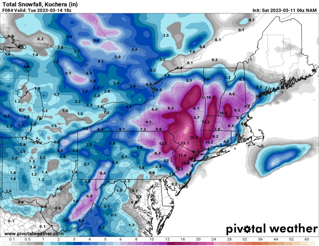
Here is Kuchera. I think 3-5" of this N&W of NYC is from tonight's storm.

_________________
_______________________________________________________________________________________________________
CLICK HERE to view NJ Strong Snowstorm Classifications
 Re: March 13th-14th 2023 Big Dog Potential
Kuchera will be no good in this situation since it really only weighs the 500 hPa temp.Frank_Wx wrote:jmanley32 wrote:Any snow maps from Euro? Does it give the coast NYC area anything or is all mainly inland?
Here is Kuchera. I think 3-5" of this N&W of NYC is from tonight's storm.
Compared to just using 10:1, sure Kuchera may do better in some situations. But it is extremely simplified, and only really uses 500 hPa temperature and does not take into account the actual height of DGZ and the cloud physics behind platelet growth.
I would use the dynamic ratio from weathernerds.com OR use the positive snow depth field from models.

Quietace- Meteorologist - Mod

- Posts : 3689
Reputation : 33
Join date : 2013-01-07
Age : 27
Location : Point Pleasant, NJ
heehaw453 likes this post
 Re: March 13th-14th 2023 Big Dog Potential
I take it as a good sign that you are posting more on this threat. Your meteorological acumen is as ostensible as day and wish you and Ray would post more.Quietace wrote:Kuchera will be no good in this situation since it really only weighs the 500 hPa temp.Frank_Wx wrote:jmanley32 wrote:Any snow maps from Euro? Does it give the coast NYC area anything or is all mainly inland?
Here is Kuchera. I think 3-5" of this N&W of NYC is from tonight's storm.
Compared to just using 10:1, sure Kuchera may do better in some situations. But it is extremely simplified, and only really uses 500 hPa temperature and does not take into account the actual height of DGZ and the cloud physics behind platelet growth.
I would use the dynamic ratio from weathernerds.com OR use the positive snow depth field from models.
heehaw453- Advanced Forecaster

- Posts : 3906
Reputation : 86
Join date : 2014-01-20
Location : Bedminster Township, PA Elevation 600' ASL
 Re: March 13th-14th 2023 Big Dog Potential
Me too. I know nothing. You all are…
profund
profund

dkodgis- Senior Enthusiast

- Posts : 2560
Reputation : 98
Join date : 2013-12-29
heehaw453- Advanced Forecaster

- Posts : 3906
Reputation : 86
Join date : 2014-01-20
Location : Bedminster Township, PA Elevation 600' ASL
jmanley32 likes this post
 Re: March 13th-14th 2023 Big Dog Potential
But for my area that all falls Mon/Tues I assume because for tonight snow maps arent showing much unless north of 287? the higher amounts slowly are dropping further south. I am shocked your using the k map.Frank_Wx wrote:jmanley32 wrote:Any snow maps from Euro? Does it give the coast NYC area anything or is all mainly inland?
Here is Kuchera. I think 3-5" of this N&W of NYC is from tonight's storm.
Also what are the odds of 8-12 happening around just north of nyc as shown (I would be plenty happy with that btw)? I realize it is 3+ days out and snow maps probably mean little right now. Still concerned GFS is not really biting, though in my reading looks like it may be making strides. But they GFS has come out on top b4. When will you be putting your 1st call out? My guess is Sunday if things look decent?

jmanley32- Senior Enthusiast

- Posts : 20535
Reputation : 108
Join date : 2013-12-12
Age : 43
Location : Yonkers, NY
 Re: March 13th-14th 2023 Big Dog Potential
Accuwx currently has 0 snow for NYC are and majority of NJ staying all rain even coastal CT and cape. But saying 40-65 mph winds (which I had no idea was going to be a issue) will lead to regional and widespread power outages, something I do not want as I need my internet and power also heat.

jmanley32- Senior Enthusiast

- Posts : 20535
Reputation : 108
Join date : 2013-12-12
Age : 43
Location : Yonkers, NY
 Re: March 13th-14th 2023 Big Dog Potential
Glad someone else saw the wind….the gusts to 65mph are a clear indication that this is a potent storm!
Coachgriff- Posts : 57
Reputation : 0
Join date : 2022-01-29
 Re: March 13th-14th 2023 Big Dog Potential
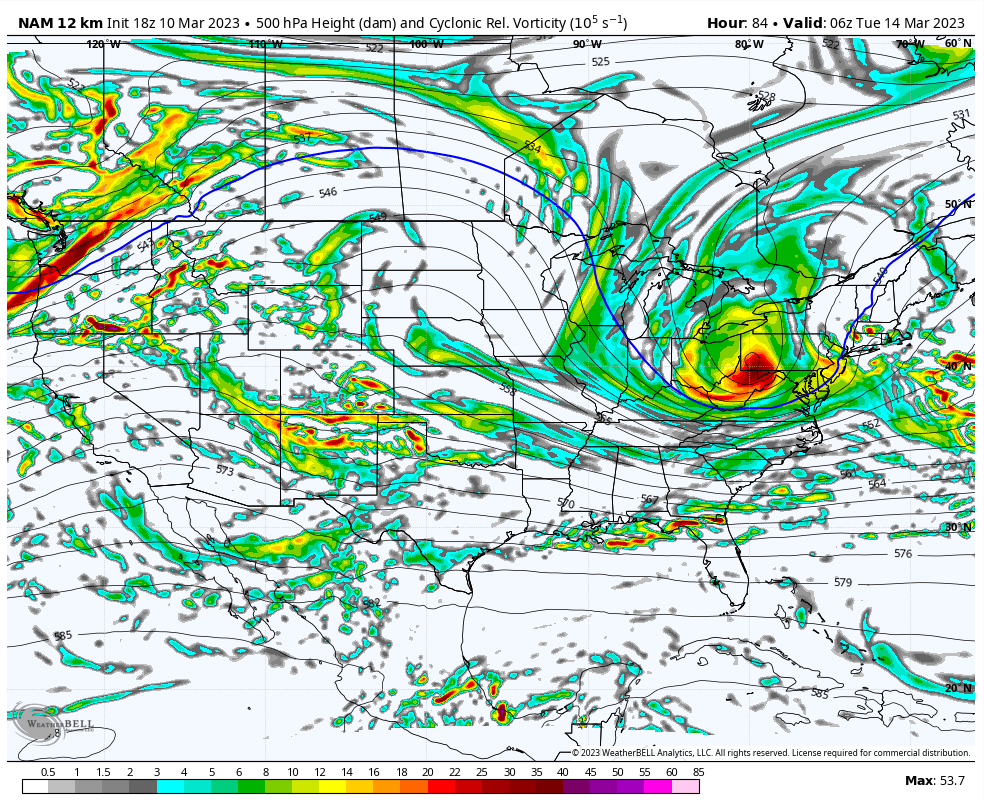
I know it’s the Nam, but it went way west at 0z. It shows a coastal hugger with heavy rain turning to heavy snow. Let’s see if it’s onto something.

nutleyblizzard- Senior Enthusiast

- Posts : 1954
Reputation : 41
Join date : 2014-01-30
Age : 58
Location : Nutley, new jersey
1190ftalt likes this post
 Re: March 13th-14th 2023 Big Dog Potential
the 00z nam is a beast and would give most of the area including nyc after beginning as rain a big snowstorm. Doesnt go past 84 hrs but if it did it buries. I sure hope it is right and if can be just a bit more east to not start as rain even better but i msybe this senario if to occur would b best bet.nutleyblizzard wrote:I know it’s the Nam, but it went way west at 0z. It shows a coastal hugger with heavy rain turning to heavy snow. Let’s see if it’s onto something.

jmanley32- Senior Enthusiast

- Posts : 20535
Reputation : 108
Join date : 2013-12-12
Age : 43
Location : Yonkers, NY
 Re: March 13th-14th 2023 Big Dog Potential
Euro coming in west, looks somewhat similar to NAM. I cannot see precip types on TT so if someone has the r/s maps and snow map b nice to post, or is there anywhere free to see it? I know most euro products are not free. Still blows up a bit too late, but map 5 mb lower at hr 84 979.
Found it on pivotal eww, Euro is way warm rain to mix for almost everyone even well inland, doc and CP do well. I dont get why Euro is further SE than NAM but NAM shows almost all snow once the quick change from rain. Looks like the Euro has less cold air to work with the temps crash quick on the NAM all way to coast.
Found it on pivotal eww, Euro is way warm rain to mix for almost everyone even well inland, doc and CP do well. I dont get why Euro is further SE than NAM but NAM shows almost all snow once the quick change from rain. Looks like the Euro has less cold air to work with the temps crash quick on the NAM all way to coast.

jmanley32- Senior Enthusiast

- Posts : 20535
Reputation : 108
Join date : 2013-12-12
Age : 43
Location : Yonkers, NY

jmanley32- Senior Enthusiast

- Posts : 20535
Reputation : 108
Join date : 2013-12-12
Age : 43
Location : Yonkers, NY
 Re: March 13th-14th 2023 Big Dog Potential
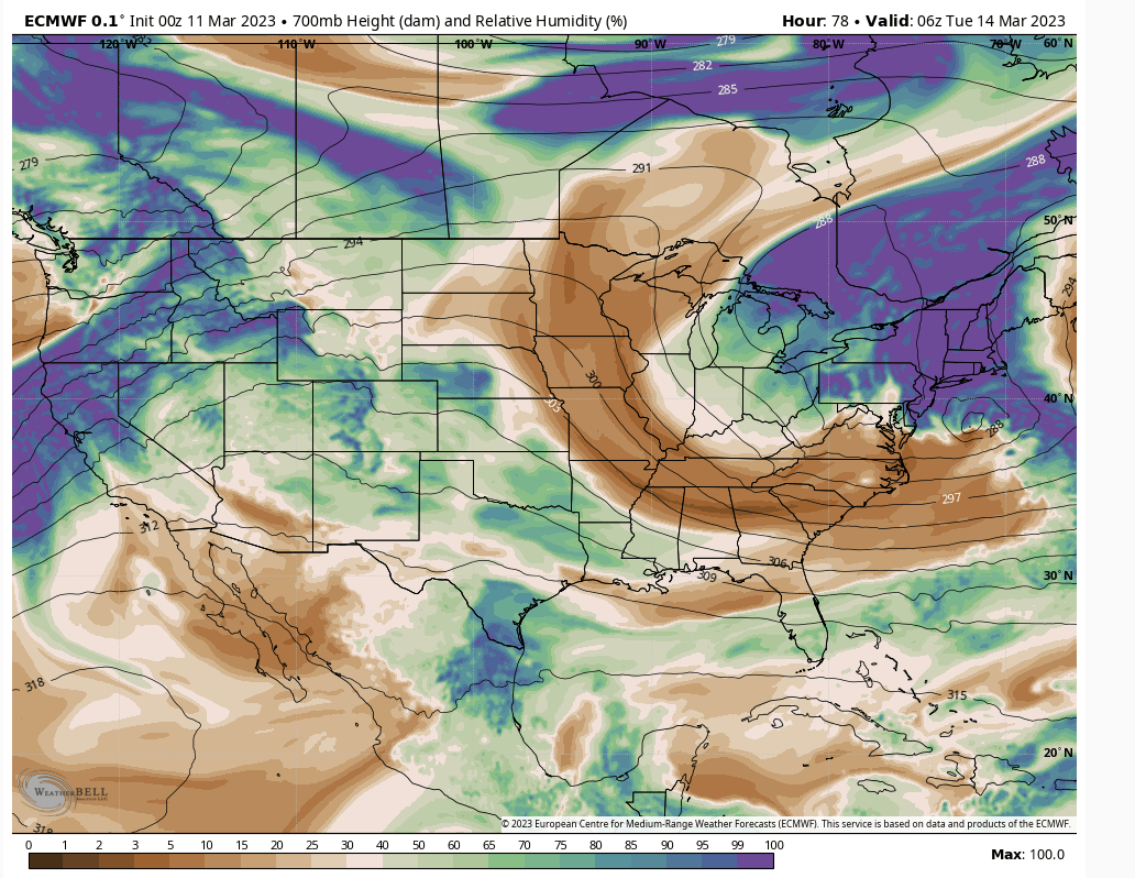
Im not going poo poo this threat because it's legit for ELI, LHV and possibly south/west of there. The maturity and progression factor is my concern. Moisture transport tells a lot. This thing is beginning to rapidly intensify and closing off as it hits 40N at 700mb. One of two things can make this impactful south of LI/LHV. It stalls out as it's intensifying or the ULL digs more and it's able to interact with the offshore energy sooner.
IMO what would happen with this is dry air works in on the backside and limits this for folks south LHV and west of LI. This is what we're on this board for though. I can think of not a more interesting event all season.
IMO what would happen with this is dry air works in on the backside and limits this for folks south LHV and west of LI. This is what we're on this board for though. I can think of not a more interesting event all season.

heehaw453- Advanced Forecaster

- Posts : 3906
Reputation : 86
Join date : 2014-01-20
Location : Bedminster Township, PA Elevation 600' ASL
 Re: March 13th-14th 2023 Big Dog Potential
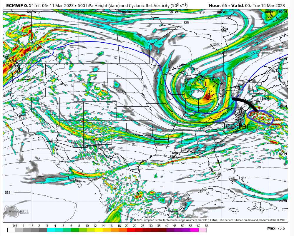
Looking at 06Z Euro. The offshore energy just a bit too far away from the 500mb trough. That interaction needs to starting occurring IMO right there. Your big snows with this scenario are interior SNE to ALB on the I90 corridor. My guess is that's the sweet spot with this. This storm will probably occlude and retrograde as it intensifies. Going to need to see models consistently showing that interaction much earlier pretty soon I think.
Again this is not to say LHV and NW NJ won't see any snow. Not at all just not your Godzilla amounts.
Again this is not to say LHV and NW NJ won't see any snow. Not at all just not your Godzilla amounts.

heehaw453- Advanced Forecaster

- Posts : 3906
Reputation : 86
Join date : 2014-01-20
Location : Bedminster Township, PA Elevation 600' ASL
 Re: March 13th-14th 2023 Big Dog Potential
Heehaw what do you think about the snow map and nam run? Thats gives nearly everyone anywhere from 6 to 20. And the snow maps for most part have shown nada for eastern LI.

jmanley32- Senior Enthusiast

- Posts : 20535
Reputation : 108
Join date : 2013-12-12
Age : 43
Location : Yonkers, NY
 Re: March 13th-14th 2023 Big Dog Potential
I'd give something like that really really low odds. There's too much space between the 500mb trough and the offshore storm. If I saw that gap closer then would feel a lot better about that possibility. I think what is going to happen is the trough catches up around or above 40N and IMO that's just too late for Godzilla snows locally. The red flag to me is the inconsistency on the Euro on when that interaction occurs and safest bet is later than earlier.jmanley32 wrote:Heehaw what do you think about the snow map and nam run? Thats gives nearly everyone anywhere from 6 to 20.
Again though LHV, NW NJ 6" on the table? Absolutely. ELI getting hit with some nice wrap around snows absolutely on the table.
NYC, EPA most of the rest of NJ don't think this is your storm. I'd love 12Z runs to start contradicting my beliefs would absolutely love it.
heehaw453- Advanced Forecaster

- Posts : 3906
Reputation : 86
Join date : 2014-01-20
Location : Bedminster Township, PA Elevation 600' ASL
 Re: March 13th-14th 2023 Big Dog Potential
heehaw453 wrote:Looking at 06Z Euro. The offshore energy just a bit too far away from the 500mb trough. That interaction needs to starting occurring IMO right there. Your big snows with this scenario are interior SNE to ALB on the I90 corridor. My guess is that's the sweet spot with this. This storm will probably occlude and retrograde as it intensifies. Going to need to see models consistently showing that interaction much earlier pretty soon I think.
Again this is not to say LHV and NW NJ won't see any snow. Not at all just not your Godzilla amounts.
At this point with the way things are evolving if those two energies interact sooner it would be be devastating for the coastal plain for sure and even 50-75miles +\- off the coast as the slp would amplify and get pulled into the coast way too soon Alla what the NaM showed last night.
I’m not ready to make any direct claims for totals but this is a very dynamic set up. And I have a feeling no model is going to be able to handle the rapid changes between surface and mid levels. But if the euro happens verbatim I think many could see a foot
_________________
"In weather and in life, there's no winning and losing; there's only winning and learning."
WINTER 2012/2013 TOTALS 43.65"WINTER 2017/2018 TOTALS 62.85" WINTER 2022/2023 TOTALS 4.9"
WINTER 2013/2014 TOTALS 64.85"WINTER 2018/2019 TOTALS 14.25" WINTER 2023/2024 TOTALS 13.1"
WINTER 2014/2015 TOTALS 71.20"WINTER 2019/2020 TOTALS 6.35"
WINTER 2015/2016 TOTALS 35.00"WINTER 2020/2021 TOTALS 37.75"
WINTER 2016/2017 TOTALS 42.25"WINTER 2021/2022 TOTALS 31.65"

sroc4- Admin

- Posts : 8354
Reputation : 302
Join date : 2013-01-07
Location : Wading River, LI
Radz and heehaw453 like this post
 Re: March 13th-14th 2023 Big Dog Potential
And with such rapid dynamics occurring ratios are likely to change very rapidly making both the 10:1 and even Kuchera maps likely not very accurate. I believe Ace was discussing this fact yesterday.
Btw Ryan if you’re reading I have to say the level and quality of your posts is awesome! Obv we have both been on this board for a very long time so I have had the pleasure of watching your posting evolve, mature, and “season” as you have gone through and finished your schooling and up until now. It has been really fun to watch. Great job on your part and I really look forward to learning from what you have to say. Cheers brother.
Btw Ryan if you’re reading I have to say the level and quality of your posts is awesome! Obv we have both been on this board for a very long time so I have had the pleasure of watching your posting evolve, mature, and “season” as you have gone through and finished your schooling and up until now. It has been really fun to watch. Great job on your part and I really look forward to learning from what you have to say. Cheers brother.
_________________
"In weather and in life, there's no winning and losing; there's only winning and learning."
WINTER 2012/2013 TOTALS 43.65"WINTER 2017/2018 TOTALS 62.85" WINTER 2022/2023 TOTALS 4.9"
WINTER 2013/2014 TOTALS 64.85"WINTER 2018/2019 TOTALS 14.25" WINTER 2023/2024 TOTALS 13.1"
WINTER 2014/2015 TOTALS 71.20"WINTER 2019/2020 TOTALS 6.35"
WINTER 2015/2016 TOTALS 35.00"WINTER 2020/2021 TOTALS 37.75"
WINTER 2016/2017 TOTALS 42.25"WINTER 2021/2022 TOTALS 31.65"

sroc4- Admin

- Posts : 8354
Reputation : 302
Join date : 2013-01-07
Location : Wading River, LI
Frank_Wx, Radz, kalleg, essexcountypete, 1190ftalt and SENJsnowman like this post
 Re: March 13th-14th 2023 Big Dog Potential
Potential winds suggest generator time

dkodgis- Senior Enthusiast

- Posts : 2560
Reputation : 98
Join date : 2013-12-29
1190ftalt likes this post
 Re: March 13th-14th 2023 Big Dog Potential
Thank you Scott for the kind words. It has been quite the adventure.sroc4 wrote:And with such rapid dynamics occurring ratios are likely to change very rapidly making both the 10:1 and even Kuchera maps likely not very accurate. I believe Ace was discussing this fact yesterday.
Btw Ryan if you’re reading I have to say the level and quality of your posts is awesome! Obv we have both been on this board for a very long time so I have had the pleasure of watching your posting evolve, mature, and “season” as you have gone through and finished your schooling and up until now. It has been really fun to watch. Great job on your part and I really look forward to learning from what you have to say. Cheers brother.

Quietace- Meteorologist - Mod

- Posts : 3689
Reputation : 33
Join date : 2013-01-07
Age : 27
Location : Point Pleasant, NJ
sroc4 and essexcountypete like this post
 Re: March 13th-14th 2023 Big Dog Potential
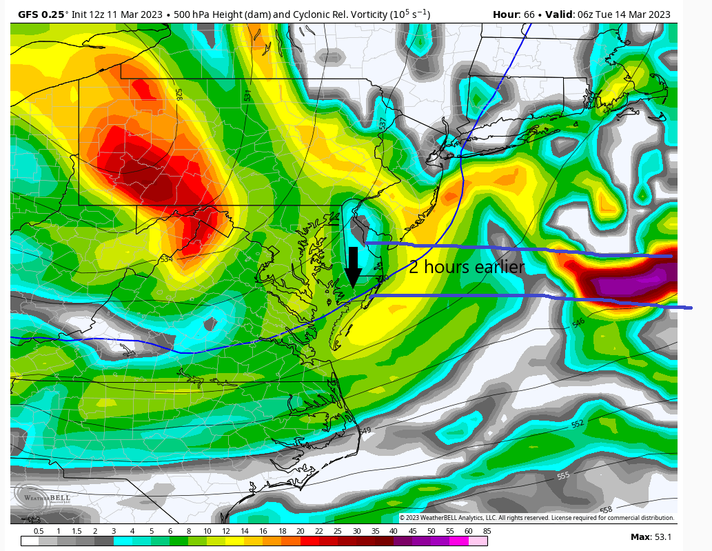
My take on 12Z GFS. I'd like to see the trough interacting with the energy about 2 hours earlier. Not a bad run but the faster this trough can tug on the L pressure the better chances for sig snow are IMO across the region. If this capture is just a bit longer to occur then this an I90 special. It's really that kind of thing and razor thin margins are well razor thin.

heehaw453- Advanced Forecaster

- Posts : 3906
Reputation : 86
Join date : 2014-01-20
Location : Bedminster Township, PA Elevation 600' ASL
kalleg likes this post
 Re: March 13th-14th 2023 Big Dog Potential
Some subtle shifts so far on the 12z guidance. On the GFS, ICON, and CMC the southern jet is a bit further north which allows for PER of the 250 hPa jet to be closer to our region. This also forces the southern stream energy a tad north, and when combined with a slightly slower northern stream 500 hPa ULL, allows for a double low structure to form.
There are essentially two main areas of peak favorability for cyclogenesis:
1) offshore: from the CVA and differential thermal advection from the southern stream. This area is also being enhanced by the single jet structure, where a broad area of vertical motion is favored in the PER of the jet. This is the "main" low.
2) Closer to the coast: this second low is forming as a result of the same reasons above, but mostly due to the approaching ULL trough creating a extremely favorable location for cyclogenesis. This is the classic location for the low level extratropical cyclone to form given the general dynamical and thermal favorability for height falls and extratropical cyclone development.
The questions become:
1) Will the southern stream vorticity be far away enough to not be directly "attached" to the separate ULL forcing. Or is it being modeled to fast and to far south?
2) If it is too far ahead of the UL feature, will it be the dominant low? If so, how can this secondary low impact thermals and create enhanced frontogenesis areas near it to impact the coastal tristate region? If it is not, how quickly does the low develop, and when does it cut off and move left longitudinally, and how does that impact the precipitation extent back into the tristate area?

Quietace- Meteorologist - Mod

- Posts : 3689
Reputation : 33
Join date : 2013-01-07
Age : 27
Location : Point Pleasant, NJ
Frank_Wx, sroc4, kalleg, oldtimer, heehaw453, Meepers55 and Coachgriff like this post
 Re: March 13th-14th 2023 Big Dog Potential
Impressive trend in the latest GFS run. The trough is more robust and does a better job of controlling the H5 energy. The energy ahead of the ULL - the southern piece Ryan is talking about - is causing tremendous uncertainty with how this plays out at the surface.


_________________
_______________________________________________________________________________________________________
CLICK HERE to view NJ Strong Snowstorm Classifications
Page 2 of 10 •  1, 2, 3, 4, 5, 6, 7, 8, 9, 10
Page 2 of 10
Permissions in this forum:
You cannot reply to topics in this forum|
|
|

 Home
Home