March 13th-14th 2023 Big Dog Potential
+22
SENJsnowman
weatherwatchermom
essexcountypete
Dunnzoo
aiannone
MattyICE
CPcantmeasuresnow
CNWestMilford
phil155
lglickman1
hyde345
Frank_Wx
nutleyblizzard
amugs
docstox12
Carvin
jmanley32
dkodgis
Coachgriff
Quietace
heehaw453
sroc4
26 posters
Page 4 of 10
Page 4 of 10 •  1, 2, 3, 4, 5, 6, 7, 8, 9, 10
jmanley32- Senior Enthusiast

- Posts : 20535
Join date : 2013-12-12
 Re: March 13th-14th 2023 Big Dog Potential
This is going to be something special for the Catskills and Adirondack’s if the current projections hold…forecast for Lake George is 1-2ft!!
Coachgriff- Posts : 57
Reputation : 0
Join date : 2022-01-29
CPcantmeasuresnow likes this post
 Re: March 13th-14th 2023 Big Dog Potential
I think Hyde is covered by Albany NWS. I expect Upton NWS will be issuing one for LHV shortly. If models hold tomorrow this is worthy of a trip up the Hudson. It's only a question how far one has to go at this point.
URGENT - WINTER WEATHER MESSAGE
National Weather Service Albany NY
243 PM EST Sat Mar 11 2023
CTZ013-NYZ032-038>040-043-048>050-053-054-060-061-065-066-084-
121100-
/O.NEW.KALY.WS.A.0006.230313T1800Z-230315T1200Z/
Southern Litchfield-Northern Herkimer-Southern Herkimer-
Southern Fulton-Montgomery-Northern Washington-
Western Schenectady-Eastern Schenectady-Southern Saratoga-
Western Rensselaer-Eastern Rensselaer-Western Columbia-
Eastern Columbia-Western Dutchess-Eastern Dutchess-
Southern Washington-
Including the cities of Oakville, Gaylordsville, New Milford,
Terryville, Thomaston, Big Moose, Eagle Bay, McKeever, Old Forge,
Atwell, Nobleboro, Northwood, Ilion, Herkimer, Little Falls,
Mohawk, Frankfort, Dolgeville, Gloversville, Johnstown,
Amsterdam, Huletts Landing, Whitehall, Granville, Mariaville,
Delanson, Duanesburg, Schenectady, Rotterdam, Burnt Hills,
Ballston Spa, Mechanicville, Clifton Park, Waterford, Troy,
Berlin, Eagle Bridge, Hoosick Falls, Stephentown, Hudson,
New Lebanon, Poughkeepsie, Beacon, Arlington, Pawling, Wingdale,
Dover Plains, Millbrook, Stanfordville, Pine Plains, Amenia,
Hudson Falls, Fort Edward, Cambridge, Greenwich, Middle Falls,
and North Easton
243 PM EST Sat Mar 11 2023
...WINTER STORM WATCH IN EFFECT FROM MONDAY AFTERNOON THROUGH
WEDNESDAY MORNING...
* WHAT...Heavy wet snow possible. Total snow accumulations of one
to one and a half feet possible. Winds could gust as high as 40
mph at times.
* WHERE...Hudson and Mohawk Valleys of eastern New York as well
as southern Litchfield County in northwestern Connecticut.
* WHEN...From Monday afternoon through Wednesday morning.
* IMPACTS...Travel could be very difficult to impossible. The
hazardous conditions could impact the morning and evening
commutes.
* ADDITIONAL DETAILS...This has the potential of being a long
duration and high-impact snow event for eastern New York and
western New England. Heavy wet snow combined with strong winds
will likely lead to downed trees and power outages across the
area. Please begin preparing now for this upcoming winter storm
event.
PRECAUTIONARY/PREPAREDNESS ACTIONS...
Monitor the latest forecasts for updates on this situation.
&&
$$
heehaw453- Advanced Forecaster

- Posts : 3906
Reputation : 86
Join date : 2014-01-20
Location : Bedminster Township, PA Elevation 600' ASL
 Re: March 13th-14th 2023 Big Dog Potential
Yep. I think I90 Berkshires, Worcester and into Albany will do very well and that's my sweet spot with this one.Coachgriff wrote:This is going to be something special for the Catskills and Adirondack’s if the current projections hold…forecast for Lake George is 1-2ft!!
heehaw453- Advanced Forecaster

- Posts : 3906
Reputation : 86
Join date : 2014-01-20
Location : Bedminster Township, PA Elevation 600' ASL
 Re: March 13th-14th 2023 Big Dog Potential
Where is CP? He should be jumping in glee at 1-2 ft!!

jmanley32- Senior Enthusiast

- Posts : 20535
Reputation : 108
Join date : 2013-12-12
Age : 43
Location : Yonkers, NY
heehaw453- Advanced Forecaster

- Posts : 3906
Reputation : 86
Join date : 2014-01-20
Location : Bedminster Township, PA Elevation 600' ASL
 Re: March 13th-14th 2023 Big Dog Potential
Is this going to basically be a nowcast for NYC and parts of jersey and LI? If so it will help a bit in terms of wondering what will happen. I mean are within 48-72 hrs. Sees like as years have gone by we have had less and less idea until almost game time or even during. Imagine the CCB will be the hardest thing to pinpoint. Well Nam certainly on surface went completely different almost all rain even well inland, hot spot shifted to eastern Mass, just shows how volitile this set up is. I had 16 inches last night to 1 inch at 18z lol. Just goes to show how much you must take these with a grain of salt.

jmanley32- Senior Enthusiast

- Posts : 20535
Reputation : 108
Join date : 2013-12-12
Age : 43
Location : Yonkers, NY
 Re: March 13th-14th 2023 Big Dog Potential
The big picture to me is no anomalous cold air in place. Huge red flag for coastal plain sig snows. The other red flag is the ULL and the trajectory it's coming from. While I think it's better than a pure Miller B we still are dealing with phasing and consolidation of energy. That is pretty complicated process and not a high margin error since it occurs not far from our latitude. I'm going to have to see it to believe for the Jersey coastal plain and NYC proper. I won't at all be surprised to see no or very little snow accumulations in either of those areas. Different story NW suburbs of NYC where I think sig snow is on the table for now. LI just not sure, but I could see some moderate impacts there.jmanley32 wrote:Is this going to basically be a nowcast for NYC and parts of jersey and LI? If so it will help a bit in terms of wondering what will happen. I mean are within 48-72 hrs. Sees like as years have gone by we have had less and less idea until almost game time or even during. Imagine the CCB will be the hardest thing to pinpoint. Well Nam certainly on surface went completely different almost all rain even well inland, hot spot shifted to eastern Mass, just shows how volitile this set up is. I had 16 inches last night to 1 inch at 18z lol. Just goes to show how much you must take these with a grain of salt.
I have no ego for being wrong and hope I am.
heehaw453- Advanced Forecaster

- Posts : 3906
Reputation : 86
Join date : 2014-01-20
Location : Bedminster Township, PA Elevation 600' ASL
 Re: March 13th-14th 2023 Big Dog Potential
Suburbs meaning how far north from NYC? I mean technically I am a suburb in fact a whole nother county but the very fringe of the bronx, not asking for exact amounts IMBY question but is that far enough north to possibly still see snow? Sorry but I hope you are wrong too lolheehaw453 wrote:The big picture to me is no anomalous cold air in place. Huge red flag for coastal plain sig snows. The other red flag is the ULL and the trajectory it's coming from. While I think it's better than a pure Miller B we still are dealing with phasing and consolidation of energy. That is pretty complicated process and not a high margin error since it occurs not far from our latitude. I'm going to have to see it to believe for the Jersey coastal plain and NYC proper. I won't at all be surprised to see no or very little snow accumulations in either of those areas. Different story NW suburbs of NYC where I think sig snow is on the table for now. LI just not sure, but I could see some moderate impacts there.jmanley32 wrote:Is this going to basically be a nowcast for NYC and parts of jersey and LI? If so it will help a bit in terms of wondering what will happen. I mean are within 48-72 hrs. Sees like as years have gone by we have had less and less idea until almost game time or even during. Imagine the CCB will be the hardest thing to pinpoint. Well Nam certainly on surface went completely different almost all rain even well inland, hot spot shifted to eastern Mass, just shows how volitile this set up is. I had 16 inches last night to 1 inch at 18z lol. Just goes to show how much you must take these with a grain of salt.
I have no ego for being wrong and hope I am.

jmanley32- Senior Enthusiast

- Posts : 20535
Reputation : 108
Join date : 2013-12-12
Age : 43
Location : Yonkers, NY
 Re: March 13th-14th 2023 Big Dog Potential
Hard to say Jman.jmanley32 wrote:Suburbs meaning how far north from NYC? I mean technically I am a suburb in fact a whole nother county but the very fringe of the bronx, not asking for exact amounts IMBY question but is that far enough north to possibly still see snow? Sorry but I hope you are wrong too lolheehaw453 wrote:The big picture to me is no anomalous cold air in place. Huge red flag for coastal plain sig snows. The other red flag is the ULL and the trajectory it's coming from. While I think it's better than a pure Miller B we still are dealing with phasing and consolidation of energy. That is pretty complicated process and not a high margin error since it occurs not far from our latitude. I'm going to have to see it to believe for the Jersey coastal plain and NYC proper. I won't at all be surprised to see no or very little snow accumulations in either of those areas. Different story NW suburbs of NYC where I think sig snow is on the table for now. LI just not sure, but I could see some moderate impacts there.jmanley32 wrote:Is this going to basically be a nowcast for NYC and parts of jersey and LI? If so it will help a bit in terms of wondering what will happen. I mean are within 48-72 hrs. Sees like as years have gone by we have had less and less idea until almost game time or even during. Imagine the CCB will be the hardest thing to pinpoint. Well Nam certainly on surface went completely different almost all rain even well inland, hot spot shifted to eastern Mass, just shows how volitile this set up is. I had 16 inches last night to 1 inch at 18z lol. Just goes to show how much you must take these with a grain of salt.
I have no ego for being wrong and hope I am.
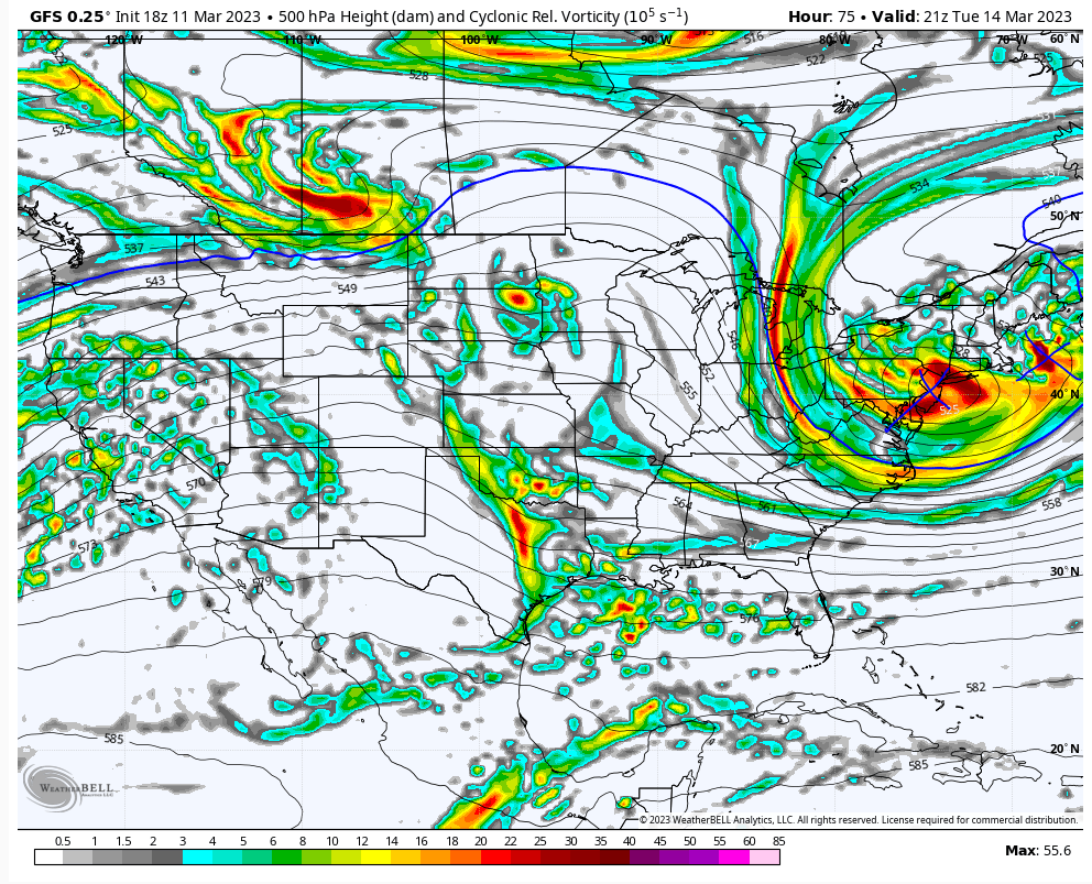
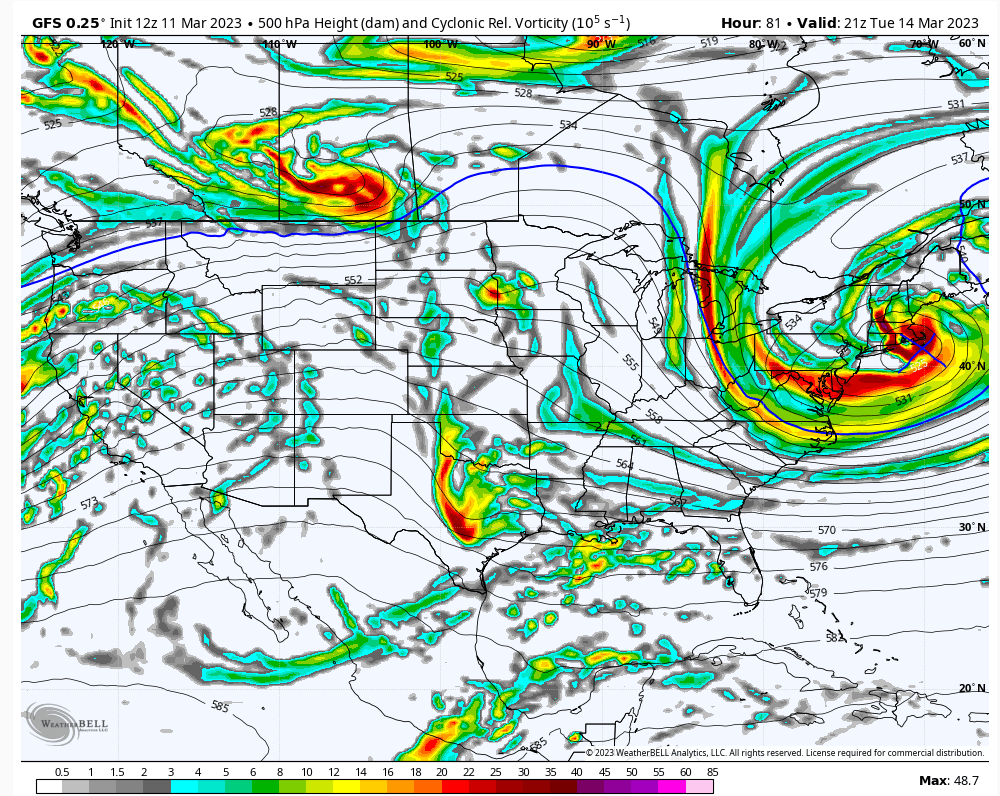
If the offshore energy gets kicked out by the ULL as it hits the coast this will be small minimal snow except maybe further NYC suburbs pic1. Pic2 shows them better consolidated and then NYC and its immediate suburbs have a shot at something much better. Models going back and forth on that idea.
heehaw453- Advanced Forecaster

- Posts : 3906
Reputation : 86
Join date : 2014-01-20
Location : Bedminster Township, PA Elevation 600' ASL
 Re: March 13th-14th 2023 Big Dog Potential
Well 18z GFS reverted back to a solution that keeps almost everyone rain and shifted the heaviest snow north and east. And the cycle goes round and round. I presume this is not what Frank wanted to see or any of you all.

jmanley32- Senior Enthusiast

- Posts : 20535
Reputation : 108
Join date : 2013-12-12
Age : 43
Location : Yonkers, NY
 Re: March 13th-14th 2023 Big Dog Potential
jmanley32 wrote:Well 18z GFS reverted back to a solution that keeps almost everyone rain and shifted the heaviest snow north and east. And the cycle goes round and round. I presume this is not what Frank wanted to see or any of you all.
Not to state the obvious, but this is definitely not our winter
lglickman1- Pro Enthusiast

- Posts : 319
Reputation : 0
Join date : 2013-02-05
Location : New Rochelle, NY
jmanley32 likes this post
 Re: March 13th-14th 2023 Big Dog Potential
Much like my Dad used to say with the NY Giants many years ago.... wait till next year
phil155- Pro Enthusiast

- Posts : 483
Reputation : 4
Join date : 2019-12-16
kalleg and jmanley32 like this post
 Re: March 13th-14th 2023 Big Dog Potential
jmanley32 wrote:Well 18z GFS reverted back to a solution that keeps almost everyone rain and shifted the heaviest snow north and east. And the cycle goes round and round. I presume this is not what Frank wanted to see or any of you all.
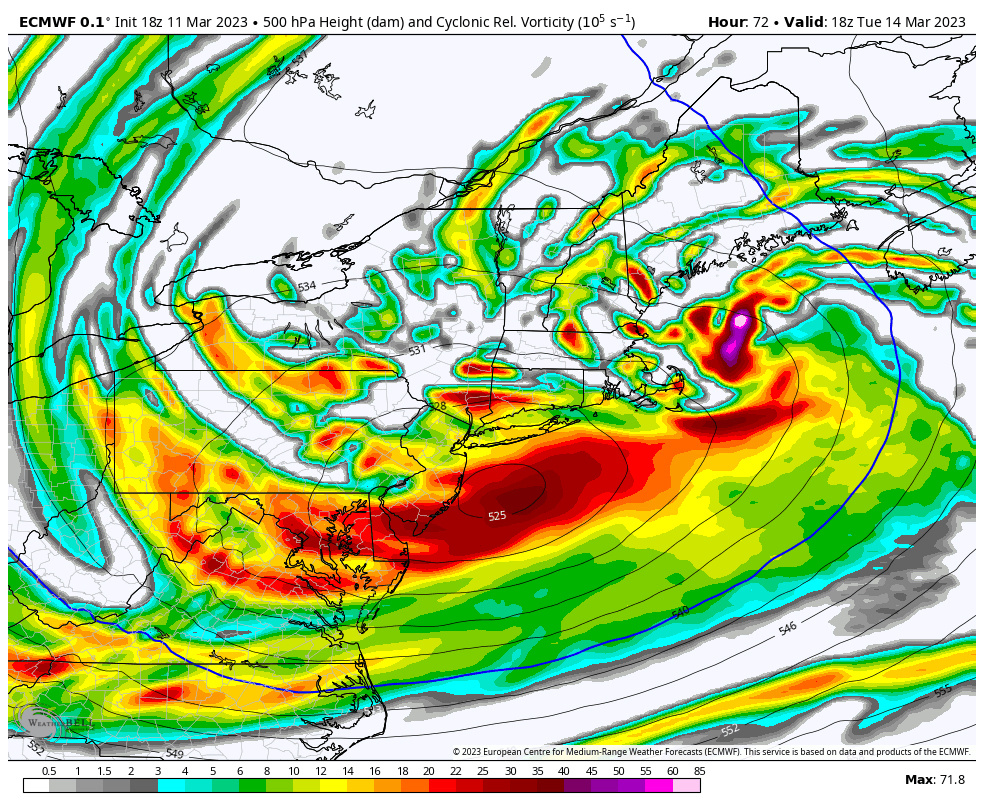
But the GFS ensembles disagree with the OP. New Euro is further south and west.

CNWestMilford- Posts : 43
Reputation : 1
Join date : 2020-12-15
Age : 47
Location : West Milford
 Re: March 13th-14th 2023 Big Dog Potential
jmanley32 wrote:Well 18z GFS reverted back to a solution that keeps almost everyone rain and shifted the heaviest snow north and east. And the cycle goes round and round. I presume this is not what Frank wanted to see or any of you all.
How did it shift the heaviest snow east? Connecticut, Rhode Island, Long Island and SE Massachusetts get almost nothing on that run.

CPcantmeasuresnow- Wx Statistician Guru

- Posts : 7274
Reputation : 230
Join date : 2013-01-07
Age : 103
Location : Eastern Orange County, NY
 Re: March 13th-14th 2023 Big Dog Potential
You are right I looked too quick, it was mainly a shift north, slight east in northern areas of New England.CPcantmeasuresnow wrote:jmanley32 wrote:Well 18z GFS reverted back to a solution that keeps almost everyone rain and shifted the heaviest snow north and east. And the cycle goes round and round. I presume this is not what Frank wanted to see or any of you all.
How did it shift the heaviest snow east? Connecticut, Rhode Island, Long Island and SE Massachusetts get almost nothing on that run.

jmanley32- Senior Enthusiast

- Posts : 20535
Reputation : 108
Join date : 2013-12-12
Age : 43
Location : Yonkers, NY
docstox12 and CPcantmeasuresnow like this post
 Re: March 13th-14th 2023 Big Dog Potential
At this point we may not know what's going to happen until Wednesday lol. SR models will be coming into range tomorrow so lets see what they do.CNWestMilford wrote:jmanley32 wrote:Well 18z GFS reverted back to a solution that keeps almost everyone rain and shifted the heaviest snow north and east. And the cycle goes round and round. I presume this is not what Frank wanted to see or any of you all.
But the GFS ensembles disagree with the OP. New Euro is further south and west.

jmanley32- Senior Enthusiast

- Posts : 20535
Reputation : 108
Join date : 2013-12-12
Age : 43
Location : Yonkers, NY
 Re: March 13th-14th 2023 Big Dog Potential
Winter storm watch here for me ATM forecast for 5 to 10 inches.

docstox12- Wx Statistician Guru

- Posts : 8530
Reputation : 222
Join date : 2013-01-07
Age : 73
Location : Monroe NY
heehaw453 likes this post
 Re: March 13th-14th 2023 Big Dog Potential
heehaw453 wrote:Hard to say Jman.jmanley32 wrote:Suburbs meaning how far north from NYC? I mean technically I am a suburb in fact a whole nother county but the very fringe of the bronx, not asking for exact amounts IMBY question but is that far enough north to possibly still see snow? Sorry but I hope you are wrong too lolheehaw453 wrote:The big picture to me is no anomalous cold air in place. Huge red flag for coastal plain sig snows. The other red flag is the ULL and the trajectory it's coming from. While I think it's better than a pure Miller B we still are dealing with phasing and consolidation of energy. That is pretty complicated process and not a high margin error since it occurs not far from our latitude. I'm going to have to see it to believe for the Jersey coastal plain and NYC proper. I won't at all be surprised to see no or very little snow accumulations in either of those areas. Different story NW suburbs of NYC where I think sig snow is on the table for now. LI just not sure, but I could see some moderate impacts there.jmanley32 wrote:Is this going to basically be a nowcast for NYC and parts of jersey and LI? If so it will help a bit in terms of wondering what will happen. I mean are within 48-72 hrs. Sees like as years have gone by we have had less and less idea until almost game time or even during. Imagine the CCB will be the hardest thing to pinpoint. Well Nam certainly on surface went completely different almost all rain even well inland, hot spot shifted to eastern Mass, just shows how volitile this set up is. I had 16 inches last night to 1 inch at 18z lol. Just goes to show how much you must take these with a grain of salt.
I have no ego for being wrong and hope I am.
If the offshore energy gets kicked out by the ULL as it hits the coast this will be small minimal snow except maybe further NYC suburbs pic1. Pic2 shows them better consolidated and then NYC and its immediate suburbs have a shot at something much better. Models going back and forth on that idea.
Totally agree about the delicate nature of the processes at our latitude. When we’re talking about a potential phase or capture or transfer situation. More often than not there’s a risk of slight leaks eastward which really ends up making a huge difference in our sensible weather. Where so many of us are, that tiny slip at 500 translates to a difference between nothing vs significant snowfall. The safe bet at this moment has to be against significant snow until you get well north and east of the city, imo. It’s because of that typical eastward leakage that I’d be ok seeing some over-amped solutions. But I think there won’t be solid agreement on these things until we get right in close. The Meso models are going to throw some wild solutions at some point as I’d expect them to do well in a setup like this.
Last edited by MattyICE on Sat Mar 11, 2023 7:44 pm; edited 1 time in total
MattyICE- Advanced Forecaster

- Posts : 249
Reputation : 6
Join date : 2017-11-10
Age : 38
Location : Clifton, NJ (Eastern Passaic County)
 Re: March 13th-14th 2023 Big Dog Potential
Do you have a euro snow map? That might bode well.CNWestMilford wrote:jmanley32 wrote:Well 18z GFS reverted back to a solution that keeps almost everyone rain and shifted the heaviest snow north and east. And the cycle goes round and round. I presume this is not what Frank wanted to see or any of you all.
But the GFS ensembles disagree with the OP. New Euro is further south and west.

jmanley32- Senior Enthusiast

- Posts : 20535
Reputation : 108
Join date : 2013-12-12
Age : 43
Location : Yonkers, NY
 Re: March 13th-14th 2023 Big Dog Potential
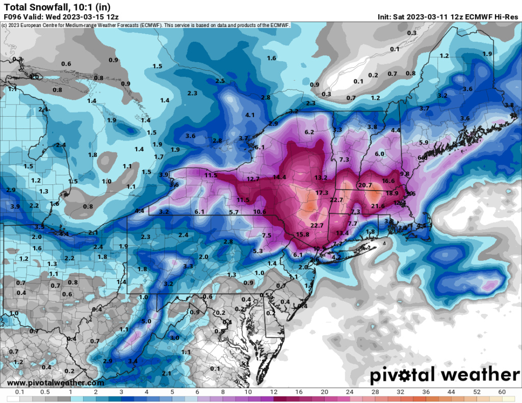
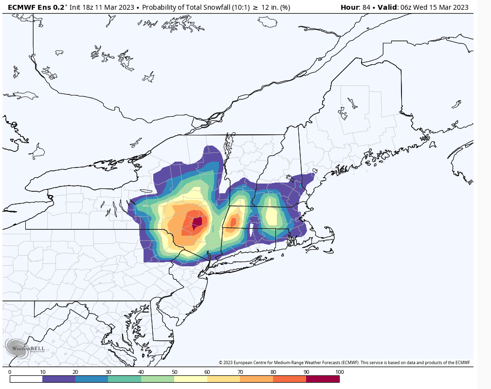
18Z Euro
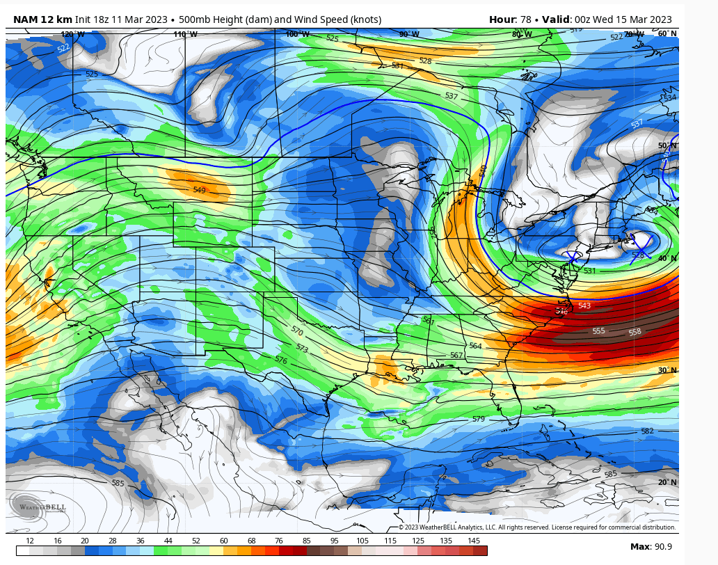
Models keep two pieces of energy separate one ahead of the 500mb trough and the offshore low. That seems to be the theme now two lows that consolidate around Cape Cod. It's kind of weird though because the height fields are not progressive. In fact you have a 50/50 which i would think should allow for that trailing L to catch up sooner.
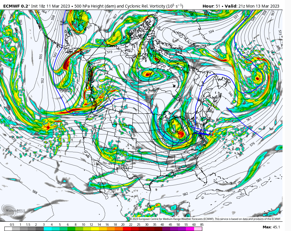
Models keep two pieces of energy separate one ahead of the 500mb trough and the offshore low. That seems to be the theme now two lows that consolidate around Cape Cod. It's kind of weird though because the height fields are not progressive. In fact you have a 50/50 which i would think should allow for that trailing L to catch up sooner.

heehaw453- Advanced Forecaster

- Posts : 3906
Reputation : 86
Join date : 2014-01-20
Location : Bedminster Township, PA Elevation 600' ASL
 Re: March 13th-14th 2023 Big Dog Potential
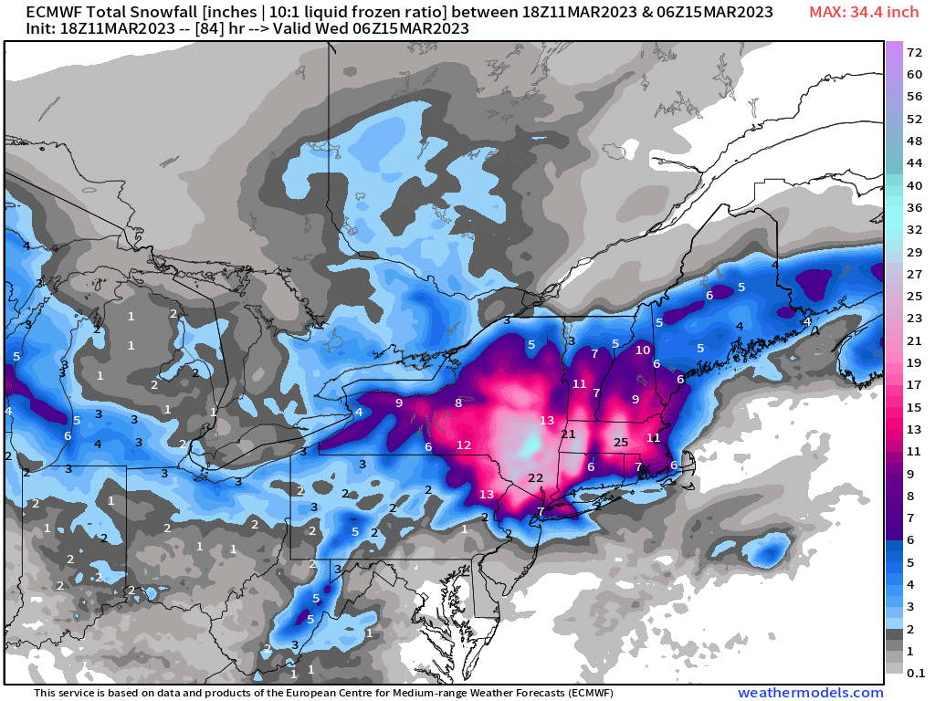
jmanley32 wrote:Do you have a euro snow map? That might bode well.CNWestMilford wrote:jmanley32 wrote:Well 18z GFS reverted back to a solution that keeps almost everyone rain and shifted the heaviest snow north and east. And the cycle goes round and round. I presume this is not what Frank wanted to see or any of you all.
But the GFS ensembles disagree with the OP. New Euro is further south and west.

CNWestMilford- Posts : 43
Reputation : 1
Join date : 2020-12-15
Age : 47
Location : West Milford
 Re: March 13th-14th 2023 Big Dog Potential
It's two pieces of energy. It's possible the southern jet is pushing the leading energy out before the trailing one before it can catch up in time. But with the blocked up Atlantic and non progressive height field I would think the trailing L would catch up sooner than off Cape Cod. If you want a big dog that's what's desirable i think.CNWestMilford wrote:jmanley32 wrote:Well 18z GFS reverted back to a solution that keeps almost everyone rain and shifted the heaviest snow north and east. And the cycle goes round and round. I presume this is not what Frank wanted to see or any of you all.
But the GFS ensembles disagree with the OP. New Euro is further south and west.
heehaw453- Advanced Forecaster

- Posts : 3906
Reputation : 86
Join date : 2014-01-20
Location : Bedminster Township, PA Elevation 600' ASL
 Re: March 13th-14th 2023 Big Dog Potential
That's exactly how I"m looking at this too. The only thing that gives me cause to pause is the height field is not progressive and there is a 50/50 in the Atlantic that in theory should slow that leading energy. 8 out of 10 times though phasing comes down to latitude. The higher you are the more margin for error. It's bad here, but exponentially worse in DC.MattyICE wrote:heehaw453 wrote:Hard to say Jman.jmanley32 wrote:Suburbs meaning how far north from NYC? I mean technically I am a suburb in fact a whole nother county but the very fringe of the bronx, not asking for exact amounts IMBY question but is that far enough north to possibly still see snow? Sorry but I hope you are wrong too lolheehaw453 wrote:The big picture to me is no anomalous cold air in place. Huge red flag for coastal plain sig snows. The other red flag is the ULL and the trajectory it's coming from. While I think it's better than a pure Miller B we still are dealing with phasing and consolidation of energy. That is pretty complicated process and not a high margin error since it occurs not far from our latitude. I'm going to have to see it to believe for the Jersey coastal plain and NYC proper. I won't at all be surprised to see no or very little snow accumulations in either of those areas. Different story NW suburbs of NYC where I think sig snow is on the table for now. LI just not sure, but I could see some moderate impacts there.jmanley32 wrote:Is this going to basically be a nowcast for NYC and parts of jersey and LI? If so it will help a bit in terms of wondering what will happen. I mean are within 48-72 hrs. Sees like as years have gone by we have had less and less idea until almost game time or even during. Imagine the CCB will be the hardest thing to pinpoint. Well Nam certainly on surface went completely different almost all rain even well inland, hot spot shifted to eastern Mass, just shows how volitile this set up is. I had 16 inches last night to 1 inch at 18z lol. Just goes to show how much you must take these with a grain of salt.
I have no ego for being wrong and hope I am.
If the offshore energy gets kicked out by the ULL as it hits the coast this will be small minimal snow except maybe further NYC suburbs pic1. Pic2 shows them better consolidated and then NYC and its immediate suburbs have a shot at something much better. Models going back and forth on that idea.
Totally agree about the delicate nature of the processes at our latitude. When we’re talking about a potential phase or capture or transfer situation. More often than not there’s a risk of slight leaks eastward which really ends up making a huge difference in our sensible weather. Where so many of us are, that tiny slip at 500 translates to a difference between nothing vs significant snowfall. The safe bet at this moment has to be against significant snow until you get well north and east of the city, imo. It’s because of that typical eastward leakage that I’d be ok seeing some over-amped solutions. But I think there won’t be solid agreement on these things until we get right in close. The Meso models are going to throw some wild solutions at some point as I’d expect them to do well in a setup like this.
heehaw453- Advanced Forecaster

- Posts : 3906
Reputation : 86
Join date : 2014-01-20
Location : Bedminster Township, PA Elevation 600' ASL
MattyICE likes this post
 Re: March 13th-14th 2023 Big Dog Potential
Not bad if its true, which I am doubtful still I want to see SR model runs.CNWestMilford wrote:jmanley32 wrote:Do you have a euro snow map? That might bode well.CNWestMilford wrote:jmanley32 wrote:Well 18z GFS reverted back to a solution that keeps almost everyone rain and shifted the heaviest snow north and east. And the cycle goes round and round. I presume this is not what Frank wanted to see or any of you all.
But the GFS ensembles disagree with the OP. New Euro is further south and west.

jmanley32- Senior Enthusiast

- Posts : 20535
Reputation : 108
Join date : 2013-12-12
Age : 43
Location : Yonkers, NY
heehaw453- Advanced Forecaster

- Posts : 3906
Reputation : 86
Join date : 2014-01-20
Location : Bedminster Township, PA Elevation 600' ASL
Page 4 of 10 •  1, 2, 3, 4, 5, 6, 7, 8, 9, 10
Page 4 of 10
Permissions in this forum:
You cannot reply to topics in this forum|
|
|

 Home
Home