March 13th-14th 2023 Big Dog Potential
+22
SENJsnowman
weatherwatchermom
essexcountypete
Dunnzoo
aiannone
MattyICE
CPcantmeasuresnow
CNWestMilford
phil155
lglickman1
hyde345
Frank_Wx
nutleyblizzard
amugs
docstox12
Carvin
jmanley32
dkodgis
Coachgriff
Quietace
heehaw453
sroc4
26 posters
Page 6 of 10
Page 6 of 10 •  1, 2, 3, 4, 5, 6, 7, 8, 9, 10
 Re: March 13th-14th 2023 Big Dog Potential
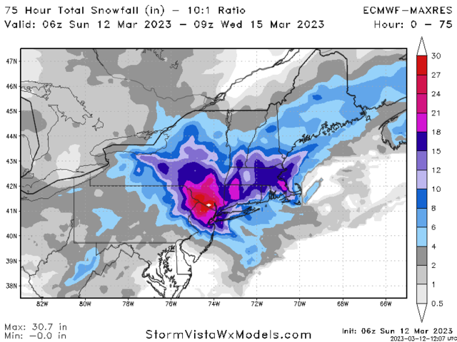
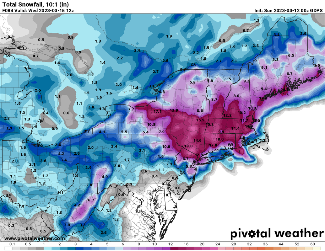
lol yup nice to look at but hard to put stock in yet.docstox12 wrote:jmanley32 wrote:thats the euro says gdps. Thats ok fpund it on pivotal i didnt realize ypu could see hi res euro on there. So 06z upped snti even more. But you know the 06z and 18z.Frank_Wx wrote:jmanley32 wrote:do you have the 00z map was it similar? And cmc was sililar in totals so we have 2 models kinda in same camp.Frank_Wx wrote:Run after run the EURO keeps showing this meso low just off the coast, allowing colder air to infiltrate down to the coast. It also keeps showing the CCB over NYC Metro. Here is the 06z snow map. I’ll see if I can find a depth map some place
We interrupt this regularly scheduled thread on the Mainland Weather Board to bring an urgent message to CP aka Wintercoldandsnoware a myth......IGNORE these clown snow maps! Believing they will come true and having it bust can have severe mental implications, including a complete collapse!That is all.
Brought to you by your genial Director of the OTI Sanitarium.
jmanley32- Senior Enthusiast

- Posts : 20535
Join date : 2013-12-12
docstox12 likes this post
 Re: March 13th-14th 2023 Big Dog Potential
Frank_Wx wrote:docstox12 wrote:jmanley32 wrote:thats the euro says gdps. Thats ok fpund it on pivotal i didnt realize ypu could see hi res euro on there. So 06z upped snti even more. But you know the 06z and 18z.Frank_Wx wrote:jmanley32 wrote:do you have the 00z map was it similar? And cmc was sililar in totals so we have 2 models kinda in same camp.Frank_Wx wrote:Run after run the EURO keeps showing this meso low just off the coast, allowing colder air to infiltrate down to the coast. It also keeps showing the CCB over NYC Metro. Here is the 06z snow map. I’ll see if I can find a depth map some place
We interrupt this regularly scheduled thread on the Mainland Weather Board to bring an urgent message to CP aka Wintercoldandsnoware a myth......IGNORE these clown snow maps! Believing they will come true and having it bust can have severe mental implications, including a complete collapse!That is all.
Brought to you by your genial Director of the OTI Sanitarium.
If the 12z runs look like this I may need seek asylum in OTI
Emperor Frank, you have Carte Blanche 24/7 at OTI.
Map mayhem at it's best!
docstox12- Wx Statistician Guru

- Posts : 8530
Join date : 2013-01-07
kalleg likes this post
 Re: March 13th-14th 2023 Big Dog Potential
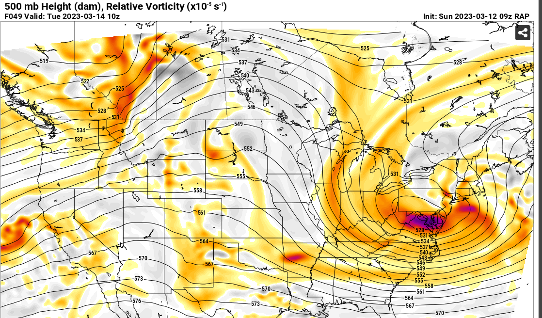
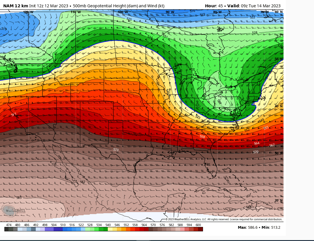
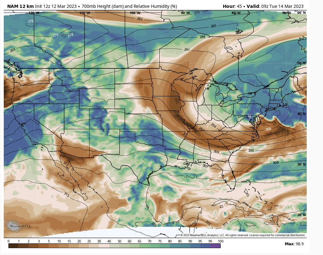
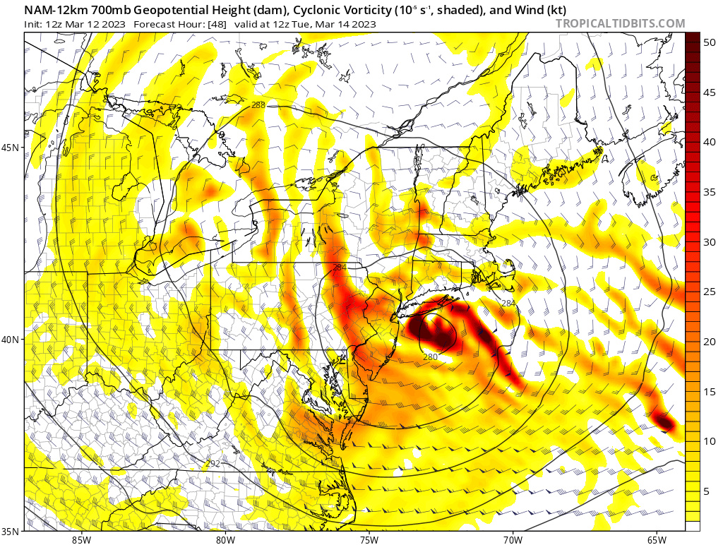
The model differences basically are down to one thing, the leading southern stream energy. Does it get the heck out of dodge and stay weak like on the NAM, or is it like the ECMWF and get wrapped up in the flow.
This is the differences between a heavy rain storm, or rain changing to a VERY HEAVY WET snow on the backside of the system for the area.
It is a tough ask right now to say which is right, and I feel we might see a large amount of changes today, especially with the meso models coming into range (one way or another). I woke up and looked at the 3km Nam and said "that looks reasonable", and then I remember that clearly it had brain washed me and I came back to my senses.

Quietace- Meteorologist - Mod

- Posts : 3689
Reputation : 33
Join date : 2013-01-07
Age : 27
Location : Point Pleasant, NJ
docstox12, CPcantmeasuresnow, kalleg, weatherwatchermom and MattyICE like this post
 Re: March 13th-14th 2023 Big Dog Potential
There is in fact a vote going on right now at the OTI lounge.

dkodgis- Senior Enthusiast

- Posts : 2560
Reputation : 98
Join date : 2013-12-29
docstox12 likes this post
 Re: March 13th-14th 2023 Big Dog Potential
Ya but it was a pure thing of beauty, those returns over MBY were insane and it just crawls and is not done at 60 hrs, if it did not start as rain we would all have a roid. I honestly hope it is at least onto something with the cold coming down to coast, but it also has Euro, CMC and SREf support. 12z and 00z will be very interesting, your right this could do a complete 180 so I am preparing for that, no OTI for me, I have my own coping skills lol And since there will be some wind 30-40mph a heavy wet snow is not good. But I guess if we want snow then thats what we will have to take.Quietace wrote:The model differences basically are down to one thing, the leading southern stream energy. Does it get the heck out of dodge and stay weak like on the NAM, or is it like the ECMWF and get wrapped up in the flow.
This is the differences between a heavy rain storm, or rain changing to a VERY HEAVY WET snow on the backside of the system for the area.
It is a tough ask right now to say which is right, and I feel we might see a large amount of changes today, especially with the meso models coming into range (one way or another). I woke up and looked at the 3km Nam and said "that looks reasonable", and then I remember that clearly it had brain washed me and I came back to my senses.

jmanley32- Senior Enthusiast

- Posts : 20535
Reputation : 108
Join date : 2013-12-12
Age : 43
Location : Yonkers, NY
heehaw453- Advanced Forecaster

- Posts : 3906
Reputation : 86
Join date : 2014-01-20
Location : Bedminster Township, PA Elevation 600' ASL
 Re: March 13th-14th 2023 Big Dog Potential
I think driving the trailing ULL south is key too. I think the ridge is key to that.Quietace wrote:The model differences basically are down to one thing, the leading southern stream energy. Does it get the heck out of dodge and stay weak like on the NAM, or is it like the ECMWF and get wrapped up in the flow.
This is the differences between a heavy rain storm, or rain changing to a VERY HEAVY WET snow on the backside of the system for the area.
It is a tough ask right now to say which is right, and I feel we might see a large amount of changes today, especially with the meso models coming into range (one way or another). I woke up and looked at the 3km Nam and said "that looks reasonable", and then I remember that clearly it had brain washed me and I came back to my senses.
heehaw453- Advanced Forecaster

- Posts : 3906
Reputation : 86
Join date : 2014-01-20
Location : Bedminster Township, PA Elevation 600' ASL
heehaw453- Advanced Forecaster

- Posts : 3906
Reputation : 86
Join date : 2014-01-20
Location : Bedminster Township, PA Elevation 600' ASL
CPcantmeasuresnow and kalleg like this post
 Re: March 13th-14th 2023 Big Dog Potential
This GIF of teh 6Z EURO shows the meso low tucked in along the jersey coast adn then spins at crawl up to CAPE COD. This is how you get a Godzilla for the NYC Metro area in March with a cooler air mass. The dynamic of this will pull a Northerly/NE wind down and cool the BL and once teh snow gets cranking in the CCB the column crashes. Also this is slated to be over night Monday which helps with stickage to roads due to teh higher sun angle now.
Watch the mini me spin below the bigger low
If this were an arctic air mass such as 2018 we'd have NO WORRIES about stickage and BL but its not, It is a MJO phase 8 which helps bigly.
Watch the mini me spin below the bigger low
That’s an impressive look on the new 06z Euro. Similar to last night. pic.twitter.com/qGFmlTPmcB
— eweather (@Eweather13) March 12, 2023
If this were an arctic air mass such as 2018 we'd have NO WORRIES about stickage and BL but its not, It is a MJO phase 8 which helps bigly.
_________________
Mugs
AKA:King: Snow Weenie
Self Proclaimed
WINTER 2014-15 : 55.12" +.02 for 6 coatings (avg. 35")
WINTER 2015-16 Total - 29.8" (Avg 35")
WINTER 2016-17 : 39.5" so far

amugs- Advanced Forecaster - Mod

- Posts : 15095
Reputation : 213
Join date : 2013-01-07
Age : 54
Location : Hillsdale,NJ
heehaw453 likes this post
 Re: March 13th-14th 2023 Big Dog Potential
_________________
Mugs
AKA:King: Snow Weenie
Self Proclaimed
WINTER 2014-15 : 55.12" +.02 for 6 coatings (avg. 35")
WINTER 2015-16 Total - 29.8" (Avg 35")
WINTER 2016-17 : 39.5" so far

amugs- Advanced Forecaster - Mod

- Posts : 15095
Reputation : 213
Join date : 2013-01-07
Age : 54
Location : Hillsdale,NJ
heehaw453- Advanced Forecaster

- Posts : 3906
Reputation : 86
Join date : 2014-01-20
Location : Bedminster Township, PA Elevation 600' ASL
 Re: March 13th-14th 2023 Big Dog Potential
_________________
Mugs
AKA:King: Snow Weenie
Self Proclaimed
WINTER 2014-15 : 55.12" +.02 for 6 coatings (avg. 35")
WINTER 2015-16 Total - 29.8" (Avg 35")
WINTER 2016-17 : 39.5" so far

amugs- Advanced Forecaster - Mod

- Posts : 15095
Reputation : 213
Join date : 2013-01-07
Age : 54
Location : Hillsdale,NJ
 Re: March 13th-14th 2023 Big Dog Potential
_________________
Mugs
AKA:King: Snow Weenie
Self Proclaimed
WINTER 2014-15 : 55.12" +.02 for 6 coatings (avg. 35")
WINTER 2015-16 Total - 29.8" (Avg 35")
WINTER 2016-17 : 39.5" so far

amugs- Advanced Forecaster - Mod

- Posts : 15095
Reputation : 213
Join date : 2013-01-07
Age : 54
Location : Hillsdale,NJ
heehaw453 likes this post
heehaw453- Advanced Forecaster

- Posts : 3906
Reputation : 86
Join date : 2014-01-20
Location : Bedminster Township, PA Elevation 600' ASL
 Re: March 13th-14th 2023 Big Dog Potential
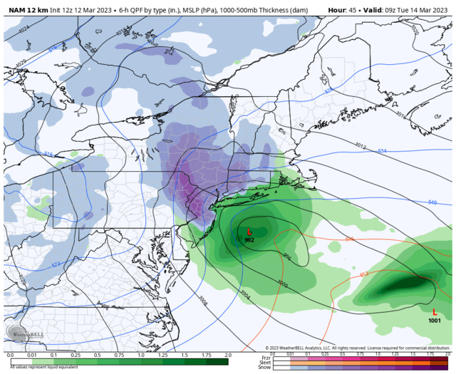
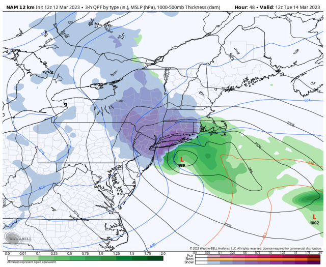
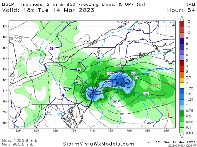
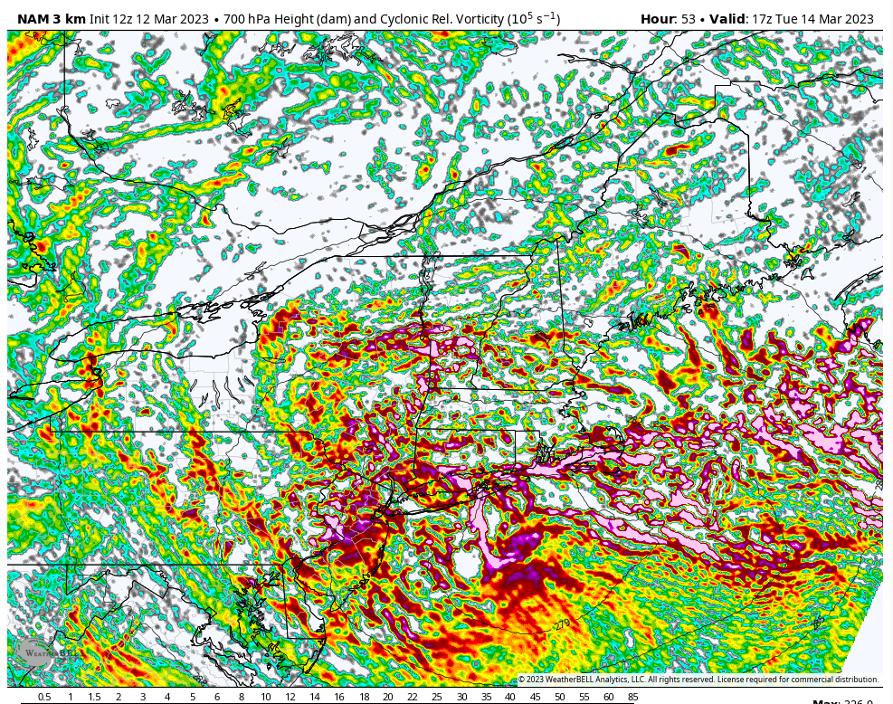
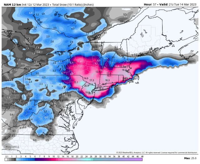
Well the 12z NAM gave the NYC metro quite a NAMing. Wow.
heehaw453- Advanced Forecaster

- Posts : 3906
Reputation : 86
Join date : 2014-01-20
Location : Bedminster Township, PA Elevation 600' ASL
 Re: March 13th-14th 2023 Big Dog Potential
ATTENTION: WE HAVE JUST BEEN NAM'D
_________________
-Alex Iannone-

aiannone- Senior Enthusiast - Mod

- Posts : 4815
Reputation : 92
Join date : 2013-01-07
Location : Saint James, LI (Northwest Suffolk Co.)
heehaw453 likes this post
heehaw453- Advanced Forecaster

- Posts : 3906
Reputation : 86
Join date : 2014-01-20
Location : Bedminster Township, PA Elevation 600' ASL
 Re: March 13th-14th 2023 Big Dog Potential
Heehaw, it looks like a dusting to an inch or two before rain for you, plus brisk winds. Maybe it will get better. Up here in northern Orange county, LHV, it looks like things may be starting early morning? Is the timing of this ‘zilla going earlier on us?
Maybe it is time to think about ‘zilla-ing out the board banner!
Maybe it is time to think about ‘zilla-ing out the board banner!

dkodgis- Senior Enthusiast

- Posts : 2560
Reputation : 98
Join date : 2013-12-29
 Re: March 13th-14th 2023 Big Dog Potential
WOWZA! Nam has 1.5" rain for NENJ on Monday, and then almost a foot of snow Tuesday. I'm going to be busy in my Deputy OEM role this week, we have a brook that goes through town that has flooding potential. With all the rain, and even if we don't get that much snow, with the snowmelt toward the end of the week upstream we could have issues.
_________________
Janet
Snowfall winter of 2023-2024 17.5"
Snowfall winter of 2022-2023 6.0"
Snowfall winter of 2021-2022 17.6" 1" sleet 2/25/22
Snowfall winter of 2020-2021 51.1"
Snowfall winter of 2019-2020 8.5"
Snowfall winter of 2018-2019 25.1"
Snowfall winter of 2017-2018 51.9"
Snowfall winter of 2016-2017 45.6"
Snowfall winter of 2015-2016 29.5"
Snowfall winter of 2014-2015 50.55"
Snowfall winter of 2013-2014 66.5"
Dunnzoo- Senior Enthusiast - Mod

- Posts : 4905
Reputation : 68
Join date : 2013-01-11
Age : 62
Location : Westwood, NJ
 Re: March 13th-14th 2023 Big Dog Potential
I have to see gfs and euro. Not jumping the gun. We’ve all been Nam’ed before.
_________________
"In weather and in life, there's no winning and losing; there's only winning and learning."
WINTER 2012/2013 TOTALS 43.65"WINTER 2017/2018 TOTALS 62.85" WINTER 2022/2023 TOTALS 4.9"
WINTER 2013/2014 TOTALS 64.85"WINTER 2018/2019 TOTALS 14.25" WINTER 2023/2024 TOTALS 13.1"
WINTER 2014/2015 TOTALS 71.20"WINTER 2019/2020 TOTALS 6.35"
WINTER 2015/2016 TOTALS 35.00"WINTER 2020/2021 TOTALS 37.75"
WINTER 2016/2017 TOTALS 42.25"WINTER 2021/2022 TOTALS 31.65"

sroc4- Admin

- Posts : 8354
Reputation : 302
Join date : 2013-01-07
Location : Wading River, LI
Frank_Wx likes this post
 Re: March 13th-14th 2023 Big Dog Potential
dkodgis wrote:Heehaw, it looks like a dusting to an inch or two before rain for you, plus brisk winds. Maybe it will get better. Up here in northern Orange county, LHV, it looks like things may be starting early morning? Is the timing of this ‘zilla going earlier on us?
Maybe it is time to think about ‘zilla-ing out the board banner!
HOLD THAT THOUGHT!!!
_________________
"In weather and in life, there's no winning and losing; there's only winning and learning."
WINTER 2012/2013 TOTALS 43.65"WINTER 2017/2018 TOTALS 62.85" WINTER 2022/2023 TOTALS 4.9"
WINTER 2013/2014 TOTALS 64.85"WINTER 2018/2019 TOTALS 14.25" WINTER 2023/2024 TOTALS 13.1"
WINTER 2014/2015 TOTALS 71.20"WINTER 2019/2020 TOTALS 6.35"
WINTER 2015/2016 TOTALS 35.00"WINTER 2020/2021 TOTALS 37.75"
WINTER 2016/2017 TOTALS 42.25"WINTER 2021/2022 TOTALS 31.65"

sroc4- Admin

- Posts : 8354
Reputation : 302
Join date : 2013-01-07
Location : Wading River, LI
 Re: March 13th-14th 2023 Big Dog Potential
_________________
_______________________________________________________________________________________________________
CLICK HERE to view NJ Strong Snowstorm Classifications
 Re: March 13th-14th 2023 Big Dog Potential
Godzilla just appeared on the NAM.
If the GFS makes a trend toward this we’re looking at one heck of a storm
If the GFS makes a trend toward this we’re looking at one heck of a storm
_________________
_______________________________________________________________________________________________________
CLICK HERE to view NJ Strong Snowstorm Classifications
 Re: March 13th-14th 2023 Big Dog Potential
no no no. I cant be nam' lol but it cant be discounted. Nws is go have egg on face if they dont put any alerts for all those areas. I have to imagine even if placement is good those amounts are overdone but who knows. Ya wpuld be one heck storm. And heavy wet snoe leads to power issues even with 35 mph winds. Still holding.
Last edited by jmanley32 on Sun Mar 12, 2023 10:58 am; edited 1 time in total

jmanley32- Senior Enthusiast

- Posts : 20535
Reputation : 108
Join date : 2013-12-12
Age : 43
Location : Yonkers, NY
 Re: March 13th-14th 2023 Big Dog Potential
_________________
_______________________________________________________________________________________________________
CLICK HERE to view NJ Strong Snowstorm Classifications
 Re: March 13th-14th 2023 Big Dog Potential
With frank posting so many posts i cant help but get a bit more intrigued. Nam also has rain change to snow earlier for coast. What is time frame that snow kicks in for tristate if it does. If this plays out im guessing i coulf b work from home tues.

jmanley32- Senior Enthusiast

- Posts : 20535
Reputation : 108
Join date : 2013-12-12
Age : 43
Location : Yonkers, NY
essexcountypete and DAYBLAZER like this post

jmanley32- Senior Enthusiast

- Posts : 20535
Reputation : 108
Join date : 2013-12-12
Age : 43
Location : Yonkers, NY
Page 6 of 10 •  1, 2, 3, 4, 5, 6, 7, 8, 9, 10
Page 6 of 10
Permissions in this forum:
You cannot reply to topics in this forum|
|
|

 Home
Home