
 Search
March 13th-14th 2023 Big Dog Potential
Page 3 of 10 •  1, 2, 3, 4, 5, 6, 7, 8, 9, 10
 ![]()
Re: March 13th-14th 2023 Big Dog Potential
![]() by Quietace Sat Mar 11, 2023 11:29 am
by Quietace Sat Mar 11, 2023 11:29 am
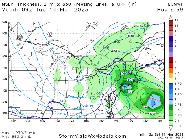
There are essentially two main areas of peak favorability for cyclogenesis:
1) offshore: from the CVA and differential thermal advection from the southern stream. This area is also being enhanced by the single jet structure, where a broad area of vertical motion is favored in the PER of the jet. This is the "main" low.
2) Closer to the coast: this second low is forming as a result of the same reasons above, but mostly due to the approaching ULL trough creating a extremely favorable location for cyclogenesis. This is the classic location for the low level extratropical cyclone to form given the general dynamical and thermal favorability for height falls and extratropical cyclone development.
The questions become:
1) Will the southern stream vorticity be far away enough to not be directly "attached" to the separate ULL forcing. Or is it being modeled to fast and to far south?
2) If it is too far ahead of the UL feature, will it be the dominant low? If so, how can this secondary low impact thermals and create enhanced frontogenesis areas near it to impact the coastal tristate region? If it is not, how quickly does the low develop, and when does it cut off and move left longitudinally, and how does that impact the precipitation extent back into the tristate area?
Quietace- Meteorologist - Mod

- Posts : 3689
Join date : 2013-01-07
Frank_Wx, sroc4, kalleg, oldtimer, heehaw453, Meepers55 and Coachgriff like this post
Re: March 13th-14th 2023 Big Dog Potential
![]() by Frank_Wx Sat Mar 11, 2023 11:54 am
by Frank_Wx Sat Mar 11, 2023 11:54 am

Frank_Wx- Godzilla Seeker

- Posts : 21305
Join date : 2013-01-05 -

Re: March 13th-14th 2023 Big Dog Potential
![]() by Coachgriff Sat Mar 11, 2023 11:59 am
by Coachgriff Sat Mar 11, 2023 11:59 am
Coachgriff- Posts : 57
Reputation : 0
Join date : 2022-01-29
Re: March 13th-14th 2023 Big Dog Potential
![]() by sroc4 Sat Mar 11, 2023 12:02 pm
by sroc4 Sat Mar 11, 2023 12:02 pm
Coachgriff wrote:Great analysis! Really interested to see how this one actually plays out in the end. At this point it appears most of NJ is out of the game with daytime highs on Monday near 50 and lows near 40. Hoping the members north and west get a real snow storm!
No way most of Nj is out of anything coach. Pay no attention to your temps
_________________
"In weather and in life, there's no winning and losing; there's only winning and learning."
WINTER 2012/2013 TOTALS 43.65"WINTER 2017/2018 TOTALS 62.85" WINTER 2022/2023 TOTALS 4.9"
WINTER 2013/2014 TOTALS 64.85"WINTER 2018/2019 TOTALS 14.25" WINTER 2023/2024 TOTALS 13.1"
WINTER 2014/2015 TOTALS 71.20"WINTER 2019/2020 TOTALS 6.35"
WINTER 2015/2016 TOTALS 35.00"WINTER 2020/2021 TOTALS 37.75"
WINTER 2016/2017 TOTALS 42.25"WINTER 2021/2022 TOTALS 31.65"

sroc4- Admin
- Posts : 8354
Reputation : 302
Join date : 2013-01-07
Location : Wading River, LI
Re: March 13th-14th 2023 Big Dog Potential
![]() by Frank_Wx Sat Mar 11, 2023 12:04 pm
by Frank_Wx Sat Mar 11, 2023 12:04 pm
South and west. That is the trend you want.
_________________
_______________________________________________________________________________________________________
CLICK HERE to view NJ Strong Snowstorm Classifications

Frank_Wx- Godzilla Seeker
- Posts : 21305
Reputation : 328
Join date : 2013-01-05
Age : 32
Location : Jersey City, NJ -
kalleg and jmanley32 like this post
Re: March 13th-14th 2023 Big Dog Potential
![]() by jmanley32 Sat Mar 11, 2023 12:05 pm
by jmanley32 Sat Mar 11, 2023 12:05 pm

jmanley32- Senior Enthusiast

- Posts : 20535
Reputation : 108
Join date : 2013-12-12
Age : 43
Location : Yonkers, NY
Re: March 13th-14th 2023 Big Dog Potential
![]() by Frank_Wx Sat Mar 11, 2023 12:07 pm
by Frank_Wx Sat Mar 11, 2023 12:07 pm
_________________
_______________________________________________________________________________________________________
CLICK HERE to view NJ Strong Snowstorm Classifications
Frank_Wx- Godzilla Seeker
- Posts : 21305
Reputation : 328
Join date : 2013-01-05
Age : 32
Location : Jersey City, NJ -
kalleg likes this post
Re: March 13th-14th 2023 Big Dog Potential
![]() by jmanley32 Sat Mar 11, 2023 12:14 pm
by jmanley32 Sat Mar 11, 2023 12:14 pm
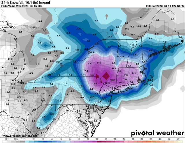
nice! Hope this keeps moving in even better. But dign me up for this at this pt. I like pivotals maps.Frank_Wx wrote:The GEFS look very good for the area. A lot of members favorable tracked the ULL and phased with the southern energy that allowed a deform band to impact the area. Here's the mean 24-hour snowfall.
jmanley32- Senior Enthusiast
- Posts : 20535
Reputation : 108
Join date : 2013-12-12
Age : 43
Location : Yonkers, NY
Re: March 13th-14th 2023 Big Dog Potential
![]() by jmanley32 Sat Mar 11, 2023 12:18 pm
by jmanley32 Sat Mar 11, 2023 12:18 pm
im not really seeing any wind with this for us. Accuwx seems think so but looking at 850mb winds it only buffets cape and coastal mass. Maybe im wrong.dkodgis wrote:Potential winds suggest generator time
jmanley32- Senior Enthusiast
- Posts : 20535
Reputation : 108
Join date : 2013-12-12
Age : 43
Location : Yonkers, NY
Re: March 13th-14th 2023 Big Dog Potential
![]() by heehaw453 Sat Mar 11, 2023 12:20 pm
by heehaw453 Sat Mar 11, 2023 12:20 pm
While I agree looking at weather app temps is not advisable it's advisable to look at the lack of CAD out ahead of the system. As I've been saying if this had a 1035 H parked in Quebec, then even w/out the dynamics coastal plain could pick up some decent snow, but now relying on pure dynamics to get that done. It just significantly reduces chances is my thought.sroc4 wrote:Coachgriff wrote:Great analysis! Really interested to see how this one actually plays out in the end. At this point it appears most of NJ is out of the game with daytime highs on Monday near 50 and lows near 40. Hoping the members north and west get a real snow storm!
No way most of Nj is out of anything coach. Pay no attention to your temps
heehaw453- Advanced Forecaster

- Posts : 3906
Reputation : 86
Join date : 2014-01-20
Location : Bedminster Township, PA Elevation 600' ASL
phil155 likes this post
Re: March 13th-14th 2023 Big Dog Potential
![]() by sroc4 Sat Mar 11, 2023 12:31 pm
by sroc4 Sat Mar 11, 2023 12:31 pm
heehaw453 wrote:While I agree looking at weather app temps is not advisable it's advisable to look at the lack of CAD out ahead of the system. As I've been saying if this had a 1035 H parked in Quebec, then even w/out the dynamics coastal plain could pick up some decent snow, but now relying on pure dynamics to get that done. It just significantly reduces chances is my thought.sroc4 wrote:Coachgriff wrote:Great analysis! Really interested to see how this one actually plays out in the end. At this point it appears most of NJ is out of the game with daytime highs on Monday near 50 and lows near 40. Hoping the members north and west get a real snow storm!
No way most of Nj is out of anything coach. Pay no attention to your temps
The comment was more in line with my forecasted temp is this therefore this won’t happen or this will. With the lack of a textbook HP to the N obv location location location, but in no way most of Nj out yet.
_________________
"In weather and in life, there's no winning and losing; there's only winning and learning."
WINTER 2012/2013 TOTALS 43.65"WINTER 2017/2018 TOTALS 62.85" WINTER 2022/2023 TOTALS 4.9"
WINTER 2013/2014 TOTALS 64.85"WINTER 2018/2019 TOTALS 14.25" WINTER 2023/2024 TOTALS 13.1"
WINTER 2014/2015 TOTALS 71.20"WINTER 2019/2020 TOTALS 6.35"
WINTER 2015/2016 TOTALS 35.00"WINTER 2020/2021 TOTALS 37.75"
WINTER 2016/2017 TOTALS 42.25"WINTER 2021/2022 TOTALS 31.65"
sroc4- Admin
- Posts : 8354
Reputation : 302
Join date : 2013-01-07
Location : Wading River, LI
weatherwatchermom likes this post
Re: March 13th-14th 2023 Big Dog Potential
![]() by Coachgriff Sat Mar 11, 2023 12:50 pm
by Coachgriff Sat Mar 11, 2023 12:50 pm
Coachgriff- Posts : 57
Reputation : 0
Join date : 2022-01-29
Re: March 13th-14th 2023 Big Dog Potential
![]() by Frank_Wx Sat Mar 11, 2023 1:05 pm
by Frank_Wx Sat Mar 11, 2023 1:05 pm
_________________
_______________________________________________________________________________________________________
CLICK HERE to view NJ Strong Snowstorm Classifications
Frank_Wx- Godzilla Seeker
- Posts : 21305
Reputation : 328
Join date : 2013-01-05
Age : 32
Location : Jersey City, NJ -
Re: March 13th-14th 2023 Big Dog Potential
![]() by Frank_Wx Sat Mar 11, 2023 1:07 pm
by Frank_Wx Sat Mar 11, 2023 1:07 pm
_________________
_______________________________________________________________________________________________________
CLICK HERE to view NJ Strong Snowstorm Classifications
Frank_Wx- Godzilla Seeker
- Posts : 21305
Reputation : 328
Join date : 2013-01-05
Age : 32
Location : Jersey City, NJ -
Re: March 13th-14th 2023 Big Dog Potential
![]() by jmanley32 Sat Mar 11, 2023 1:11 pm
by jmanley32 Sat Mar 11, 2023 1:11 pm
how does this bode for nyc area on this particular run what do temps look like i see 32 way noryh. But your excitement tells me ur intrigued. Oh im look fot 0 line right which is well south of nyc.Frank_Wx wrote:Woah, the EURO has the same baby low, or 'meso low,' that the GFS had
Last edited by jmanley32 on Sat Mar 11, 2023 1:12 pm; edited 1 time in total
jmanley32- Senior Enthusiast
- Posts : 20535
Reputation : 108
Join date : 2013-12-12
Age : 43
Location : Yonkers, NY
Re: March 13th-14th 2023 Big Dog Potential
![]() by Frank_Wx Sat Mar 11, 2023 1:11 pm
by Frank_Wx Sat Mar 11, 2023 1:11 pm
_________________
_______________________________________________________________________________________________________
CLICK HERE to view NJ Strong Snowstorm Classifications
Frank_Wx- Godzilla Seeker
- Posts : 21305
Reputation : 328
Join date : 2013-01-05
Age : 32
Location : Jersey City, NJ -
heehaw453 and Coachgriff like this post
Re: March 13th-14th 2023 Big Dog Potential
![]() by Frank_Wx Sat Mar 11, 2023 1:13 pm
by Frank_Wx Sat Mar 11, 2023 1:13 pm
_________________
_______________________________________________________________________________________________________
CLICK HERE to view NJ Strong Snowstorm Classifications
Frank_Wx- Godzilla Seeker
- Posts : 21305
Reputation : 328
Join date : 2013-01-05
Age : 32
Location : Jersey City, NJ -
Re: March 13th-14th 2023 Big Dog Potential
![]() by Frank_Wx Sat Mar 11, 2023 1:14 pm
by Frank_Wx Sat Mar 11, 2023 1:14 pm
_________________
_______________________________________________________________________________________________________
CLICK HERE to view NJ Strong Snowstorm Classifications
Frank_Wx- Godzilla Seeker
- Posts : 21305
Reputation : 328
Join date : 2013-01-05
Age : 32
Location : Jersey City, NJ -
Re: March 13th-14th 2023 Big Dog Potential
![]() by Frank_Wx Sat Mar 11, 2023 1:16 pm
by Frank_Wx Sat Mar 11, 2023 1:16 pm
_________________
_______________________________________________________________________________________________________
CLICK HERE to view NJ Strong Snowstorm Classifications
Frank_Wx- Godzilla Seeker
- Posts : 21305
Reputation : 328
Join date : 2013-01-05
Age : 32
Location : Jersey City, NJ -
Re: March 13th-14th 2023 Big Dog Potential
![]() by Frank_Wx Sat Mar 11, 2023 1:17 pm
by Frank_Wx Sat Mar 11, 2023 1:17 pm
_________________
_______________________________________________________________________________________________________
CLICK HERE to view NJ Strong Snowstorm Classifications
Frank_Wx- Godzilla Seeker
- Posts : 21305
Reputation : 328
Join date : 2013-01-05
Age : 32
Location : Jersey City, NJ -
Re: March 13th-14th 2023 Big Dog Potential
![]() by nutleyblizzard Sat Mar 11, 2023 1:32 pm
by nutleyblizzard Sat Mar 11, 2023 1:32 pm

nutleyblizzard- Senior Enthusiast
- Posts : 1954
Reputation : 41
Join date : 2014-01-30
Age : 58
Location : Nutley, new jersey
Re: March 13th-14th 2023 Big Dog Potential
![]() by jmanley32 Sat Mar 11, 2023 1:36 pm
by jmanley32 Sat Mar 11, 2023 1:36 pm
ill be totally fine with that if i can get 6 or even a bit more id be happy. 3 to 6 still ok anythimg less ehh. Hoping these trends continue. Hopefully this doesnt wobble back often we see a in between end result. But thats ususllu in nsm sr territory.Frank_Wx wrote:Thing is we keep seeing this trend favorably. So if 00z's tonight continue this trend it will put NYC Metro into significant snowfall. Not sure we'll get to Godzilla territory because of temperatures, but let's see...
Last edited by jmanley32 on Sat Mar 11, 2023 1:40 pm; edited 1 time in total
jmanley32- Senior Enthusiast
- Posts : 20535
Reputation : 108
Join date : 2013-12-12
Age : 43
Location : Yonkers, NY
Re: March 13th-14th 2023 Big Dog Potential
![]() by heehaw453 Sat Mar 11, 2023 1:39 pm
by heehaw453 Sat Mar 11, 2023 1:39 pm
It's disorganized and unconsolidated at 850 mid-levels. If it consolidated it'd be interesting. You want this thing to start rapid intensification as it moves up and potentially stall or occlude. There's not a lot of time for dilly dally at this latitude. Not impossible for that to happen, but models will sniff it out next 24 hours IMO if there's a chance.

heehaw453- Advanced Forecaster
- Posts : 3906
Reputation : 86
Join date : 2014-01-20
Location : Bedminster Township, PA Elevation 600' ASL
Re: March 13th-14th 2023 Big Dog Potential
![]() by jmanley32 Sat Mar 11, 2023 1:44 pm
by jmanley32 Sat Mar 11, 2023 1:44 pm
i would have to agree sunday eve puts us badically 24 hrs from game time. Lets hope the trens frank pointed put as well as u go in right direction. Often in past years anyways the sr has surprised for the better. Any euro snow map? On mobile kinda hard navigate pivotalheehaw453 wrote:12Z Euro
It's disorganized and unconsolidated at 850 mid-levels. If it consolidated it'd be interesting. You want this thing to start rapid intensification as it moves up and potentially stall or occlude. There's not a lot of time for dilly dally at this latitude. Not impossible for that to happen, but models will sniff it out next 24 hours IMO if there's a chance.
jmanley32- Senior Enthusiast
- Posts : 20535
Reputation : 108
Join date : 2013-12-12
Age : 43
Location : Yonkers, NY
Re: March 13th-14th 2023 Big Dog Potential
![]() by heehaw453 Sat Mar 11, 2023 2:01 pm
by heehaw453 Sat Mar 11, 2023 2:01 pm
heehaw453- Advanced Forecaster
- Posts : 3906
Reputation : 86
Join date : 2014-01-20
Location : Bedminster Township, PA Elevation 600' ASL
Re: March 13th-14th 2023 Big Dog Potential
![]() by hyde345 Sat Mar 11, 2023 2:05 pm
by hyde345 Sat Mar 11, 2023 2:05 pm


hyde345- Pro Enthusiast

- Posts : 1082
Reputation : 48
Join date : 2013-01-08
Location : Hyde Park, NY
Re: March 13th-14th 2023 Big Dog Potential
![]() by jmanley32 Sat Mar 11, 2023 2:32 pm
by jmanley32 Sat Mar 11, 2023 2:32 pm
similar to gfs. Still leaves some hope for noryh nj nyc and well nw go get crushed. That 10.4 in westchester is literally 9 miles north of me 287 area.hyde345 wrote:This is 10:1 so likely not accurate but that is all I can get on Pivotal.
jmanley32- Senior Enthusiast
- Posts : 20535
Reputation : 108
Join date : 2013-12-12
Age : 43
Location : Yonkers, NY
Page 3 of 10 • 1, 2, 3, 4, 5, 6, 7, 8, 9, 10 ![]()
|
|
|